
St. Joseph County is a county located in the U.S. state of Michigan, on the central southern border with Indiana. As of the 2020 United States Census, the population was 60,939. The county seat is Centreville.

Berrien County is a county in the U.S. state of Michigan. It is located at the southwest corner of the state's Lower Peninsula, located on the shore of Lake Michigan and sharing a land border with Indiana. As of the 2020 Census, the population was 154,316. The county seat is St. Joseph.

St. Joseph County, commonly called St. Joe County by residents, is a county located in the U.S. state of Indiana. As of the 2020 census, the population was 272,912, making it the fifth-most populous county in Indiana. Formed in 1830, it was named for the St. Joseph River which flows through it to Lake Michigan. The county seat is South Bend. St. Joseph County is part of the South Bend–Mishawaka, IN–MI "Michiana", Metropolitan Statistical Area.

Hamilton County is a county in the U.S. state of Indiana. The 2020 United States Census recorded a population of 347,467. The county seat is Noblesville.

Elkhart County is a county located in the U.S. state of Indiana. As of 2020, the county's population was 207,047. The county seat is Goshen. Elkhart County is part of the Elkhart-Goshen Metropolitan Statistical Area, which in turn is part of the South Bend-Elkhart-Mishawaka Combined Statistical Area. It is also considered part of the broader region of Northern Indiana known as Michiana, and is 20 miles (32 km) east of South Bend, Indiana, 110 miles (180 km) east of Chicago, Illinois, and 150 miles (240 km) north of Indianapolis, Indiana. The area is referred to by locals as the recreation vehicle (RV) capital of the world and is known for its sizable Amish and Old Order Mennonite population.

Westfield is a city in Hamilton County, Indiana, United States. As of the 2010 census the population was 30,068, and in 2023 the population was 58,410. Westfield is in the Indianapolis metropolitan area.
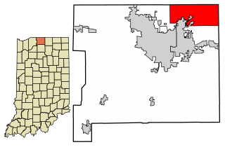
Granger is a census-designated place (CDP) in Clay and Harris townships, St. Joseph County, in the U.S. state of Indiana. The population was 30,465 at the 2010 census. Penn-Harris-Madison School Corporation and the South Bend Community School Corporation maintain the public schools in the area. Granger is part of the South Bend–Mishawaka metropolitan area as well as the larger Michiana region.

Westfield is a city in Hampden County, in the Pioneer Valley of western Massachusetts, United States. Westfield was first settled by Europeans in 1660. It is part of the Springfield, Massachusetts Metropolitan Statistical Area. The population was 40,834 at the 2020 census.

Notre Dame is a census-designated place and unincorporated community north of the city of South Bend in St. Joseph County, in the U.S. state of Indiana. It includes the campuses of three colleges: the University of Notre Dame, Saint Mary's College, and Holy Cross College. Notre Dame is split between Clay and Portage Townships. As of the 2020 census, its population was 7,234.

The Monon Trail is a rail trail located entirely within the state of Indiana. The Monon Railroad was a popular railroad line connecting the cities of Chicago and Indianapolis, with stops at major settlements along its route. After the decline of railroad travel and the sale of the company in 1987, the portion of the line between Indianapolis and Delphi, Indiana, was abandoned.

Wyatt is an unincorporated community located in Madison Township, St. Joseph County, in the U.S. state of Indiana.

Indiana's 5th congressional district is a congressional district in the U.S. state of Indiana comprising Hamilton, Madison, Delaware, Grant, and Tipton counties, as well as the large majority of Howard County. Much of its population is located in the northern suburbs of Indianapolis, including the cities of Carmel, Noblesville, and Fishers, while other population centers include Muncie, Kokomo, Anderson, and Marion. The district is predominantly white and is the wealthiest congressional district in Indiana, as measured by median income.

Warren Township is one of thirteen townships in St. Joseph County, in the U.S. state of Indiana. As of the 2000 census, its population was 6,430.

Westfield Washington Township is one of nine townships in Hamilton County, Indiana, United States. As of the 2010 census, its population was 32,884 and it contained 12,477 housing units. In 2007, the township had 29,361 residents. Due to Clay Township becoming more conservative with development due to a reduction in available land over the past few years, Westfield Washington Township has seen an increase in residential communities being developed.

Saint Joseph Township is one of twenty townships in Allen County, Indiana, United States. As of the 2010 census, its population was 72,245.
Crumstown is an unincorporated community in LaPorte and St. Joseph counties, in the U.S. state of Indiana.
Colburn is an unincorporated community in Union Township, St. Joseph County, in the U.S. state of Indiana.

Jolietville is a neighborhood of Westfield, Indiana, in Washington Township, Hamilton County, Indiana. It was formerly an unincorporated community, but was annexed by Westfield in the late 2000s or early 2010s.
Plainfield is an unincorporated community in St. Joseph County, Indiana, United States. It is along U.S. Route 20 in the north-central part of Olive Township and is bordered to the south and west by the town of New Carlisle. Via US-20, Plainfield is 13 miles (21 km) west of South Bend and 23 miles (37 km) east of Michigan City.
The South Bend–Mishawaka Metropolitan Statistical Area, sometimes referred to as Michiana, as defined by the United States Census Bureau, is an area consisting of two counties – one in northern Indiana and one in southwest Michigan (Cass), anchored by the cities of South Bend and Mishawaka in Indiana. As of the 2010 census, the MSA had a population of 319,224.


