
This is a list of properties and districts in Illinois that are on the National Register of Historic Places. There are over 1,900 in total. Of these, 85 are National Historic Landmarks. There are listings in all of the state's 102 counties.
This National Park Service list is complete through NPS recent listings posted December 1, 2023.

Fall Creek Stone Arch Bridge is located near the Adams County town of Payson, Illinois. It spans Fall Creek about 1.2 miles northeast of Payson Road, upstream from the town. The bridge has been listed on the National Register of Historic Places since November 7, 1996.
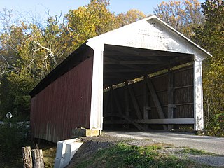
The Billie Creek Covered Bridge is a Burr Arch structure that was built by Joseph J. Daniels in 1895. J.L. Van Fossen supplied the sandstone that makes up the abutments cut from A.E. Fuel's nearby quarry.

The Melcher Covered Bridge, also known as the "Klondyke Covered Bridge", "Marion Covered Bridge", or the "Leatherwood Covered Bridge" crosses Leatherwood Creek east of Montezuma, Indiana, and is a single-span Burr Arch Truss covered bridge structure that was built by Joseph J. Daniels in 1896.
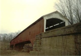
The West Union Covered Bridge formerly carried Tow Path Road over Sugar Creek north-northeast of Montezuma, Indiana. The two-span Burr Arch Truss covered bridge structure was built by Joseph J. Daniels in 1876. It is notable for being the longest standing covered bridge in Parke County, and one of the nation's best-preserved examples of the Burr truss.

Dunlap's Creek Bridge was the first arch bridge in the United States built of cast iron. It was designed by Richard Delafield and built by the United States Army Corps of Engineers. Constructed from 1836 to 1839 on the National Road in Brownsville, Pennsylvania, it remains in use today. It is listed on the National Register of Historic Places and is a National Historic Civil Engineering Landmark (1978). It is located in the Brownsville Commercial Historic District and supports Market Street, the local main thoroughfare. Due to the steep sides of the Monongahela River valley, there is only room for two short streets parallel to the river's shore and graded mild enough to be comfortable to walk before the terrain rises too steeply for business traffic.

The Generals' Highway Stone Bridges, built in 1930, are part of the Generals' Highway from the General Grant Grove of giant sequoias in Kings Canyon National Park through Sequoia National Park. One bridge spans the Marble Fork of the Kaweah River in a wooded setting, while the other, similar bridge spans Clover Creek in a bare canyon.

There are eight properties listed on the National Register of Historic Places (NRHP) in Linn County, Kansas. Two of the sites are the location of historic events. The Marais des Cygnes Massacre Site is the location of the Marais des Cygnes massacre, an 1858 event during Bleeding Kansas in which pro-slavery advocates kidnapped 11 anti-slavery settlers, killing five of them. John Brown temporarily used the site as a fort, and the property was listed on the NRHP in 1971. The Battle of Mine Creek Site preserves the location of the Battle of Mine Creek, which was fought in 1864 as part of Price's Raid during the American Civil War. Confederate general Sterling Price's army was retreating after being defeated at the Battle of Westport and was attacked by pursuing Union troops. Price's Confederate lost heavily in men and supplies. The site was added to the NRHP in 1973.

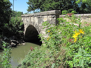
The Warrington Stone Bridge is a historic stone arch bridge carrying Brugler Road over the Paulins Kill in the Warrington section of Knowlton Township in Warren County, New Jersey, United States. The bridge was built c. 1860 and added to the National Register of Historic Places on December 16, 1977, for its significance in transportation.

The Stone Arch Bridge is a bridge in Danville, Illinois, which carries U.S. Route 136 across Stony Creek. The segmental arch bridge is 92 feet (28 m) long and built with sandstone. The bridge was built in the 1890s to facilitate Danville's expansion during an industrial boom. As various geographic and political limitations prevented the city from expanding in any directions but east and southeast, the city grew over Stony Creek, necessitating a new bridge. Mayor John Beard commissioned the bridge; during the 1890s, Beard and political rival John Cannon clashed over many issues, and Beard most likely built the bridge to demonstrate his political effectiveness. The bridge is the only segmented arch bridge remaining in east-central Illinois and is one of five stone arch bridges in the region.

Van Metre Ford Stone Bridge is a historic stone arch bridge located near Martinsburg, Berkeley County, West Virginia. Built by Pennsylvania builder Silas Harry, it was built in 1832, and is a three span bridge crossing Opequon Creek. It is 132 feet long and constructed of ashlar limestone. The center span measures 32 feet and the two side spans are each 29.5 feet long.

The Goose Creek Stone Bridge crosses Goose Creek in Loudoun County, Virginia. The 200-foot (61 m) long stone arch bridge spans the creek in four arches. Built about 1810, it is the largest stone turnpike bridge in northern Virginia, designed to carry the Ashby's Gap Turnpike across the creek. The turnpike was replaced by U.S. Route 50, which crosses the creek a short distance to the south. The bridge is no longer used for vehicular traffic. The bridge was a center of fighting in the American Civil War on June 21, 1863, during the Battle of Upperville.

Swamp Creek Road Bridge is a historic stone arch bridge located near Sumneytown in Marlborough Township, Montgomery County, Pennsylvania. The bridge was built in 1892. It has three spans totaling 76-foot-long (23 m) with an overall length of 125-foot (38 m). The bridge crosses Unami Creek.

The Old Stone Arch is a stone arch bridge along the former route of the National Road in Marshall, Illinois. The limestone bridge is 13.5 feet (4.1 m) high and 15 feet (4.6 m) across. The U.S. Army Corps of Engineers built the bridge between 1828 and 1837, the period in which the Corps rebuilt much of the National Road. The National Road, the most-traveled U.S. road in the early 1800s and the first built by the U.S. government, connected Illinois to the Eastern United States and helped bring settlers and goods to the state during its early years. The bridge has served road traffic continuously since its construction and was part of U.S. Route 40 from the route's creation to 1953.
The Old Stone Arch Bridge was a stone arch bridge located along the former route of the National Road in Clark Center, Illinois. The limestone bridge was 8.9 feet (2.7 m) high and 81.5 feet (24.8 m) long with a 17.8-foot (5.4 m) span. The U.S. Army Corps of Engineers built the bridge between 1828 and 1837, the period in which the Corps improved much of the National Road. The National Road was the first major highway built by the U.S. government and brought settlers and goods from the Eastern United States to Illinois. The bridge became part the Illinois state highway system in 1918, and later became part of U.S. Route 40; it served road traffic until 1933, when US 40 was realigned through the area.

The Sixth, Seventh, and Tenth Street Stone Arch Bridges are three stone arch bridges in Charleston, Illinois, which carry Sixth, Seventh, and Tenth Streets across the Town Branch of Cassell Creek. Prominent local stonemason Alexander Briggs built the three bridges during the 1890s, when increasing development in Charleston expanded across the creek. The three bridges were all built from locally quarried limestone, and each has a single arch design with abutments at both ends. While Charleston has thirteen bridges across the Town Branch, these three are the only stone arch bridges in the city.

Hunting Creek Railroad Bridge is a historic stone railroad bridge located at Morganton, Burke County, North Carolina. It was built about 1860, and is a two-span, stone arch bridge. It measures 130 feet long and stands about 24 feet above the creek. It was replaced by another bridge by at least 1890.

Cemetery Road Bridge is a historic bridge located in Glendale Cemetery in Washington, Illinois. The double stone arch bridge is 27 feet (8.2 m) long and carries Cemetery Road across the south branch of Farm Creek. Engineer Frederick Rickman designed the bridge for the City of Washington in 1893, and it was built the following year by stonemason Jacob Habluetzel. Habluetzel built the bridge from square cut blocks of ashlar stone. The bridge is the best-preserved bridge of its type in Tazewell County and is the only stone arch bridge in the area that is still supported solely by its arches.

The Chicago & North Western Railway Stone Arch Bridge, also known as the Kinnikinnick Creek Railway Bridge, is a historic Chicago and North Western Railway bridge that crosses South Kinnikinnick Creek east of Roscoe, Illinois. The bridge was built in 1882 to replace a wooden bridge; the line it was on opened in 1853 as part of the Galena and Chicago Union Railroad and originally connected Belvidere, Illinois and Beloit, Wisconsin. C&NW Chief Engineer Van Mienen designed the double arch dolomitic limestone bridge, which is 53 feet (16 m) long, 60 feet (18 m) wide, and 58 feet (18 m) high. The railroad allowed the sand quarrying industry in Roscoe and South Beloit to ship its products to construction sites in Chicago; the bridge is one of the few surviving remnants of the railroad in Roscoe. The bridge is the only stone-faced rubble fill bridge with more than one arch in Winnebago County; the nearest bridge of the type is a five-arch bridge in Tiffany, Wisconsin.
The Fox Creek Stone Arch Bridge is a historic bridge across Fox Creek northwest of Strong City in Chase County, Kansas. The bridge was built in 1898 by B. Landry and Sons, who contracted with the Chase County government to build it for $2,000. The company built the bridge using limestone from a local quarry and arranged it in a single stone arch. The bridge is 55 feet (17 m) long and 20 feet (6.1 m) wide. It has carried county road traffic since its opening and is also part of the Community Connection Trail, which links Strong City with Tallgrass Prairie National Preserve.


