Warren County, Missouri

Last updated

Warren County
Warren county courthouse.jpg
The Warren County Courthouse in Warrenton
Map of Missouri highlighting Warren County.svg
Location within the U.S. state of Missouri
Missouri in United States.svg
Missouri's location within the U.S.
Coordinates: 38°46′N91°10′W / 38.77°N 91.16°W / 38.77; -91.16
CountryFlag of the United States.svg United States
StateFlag of Missouri.svg  Missouri
FoundedJanuary 5, 1833
Named for General Joseph Warren
Seat Warrenton
Largest cityWarrenton
Area
  Total438 sq mi (1,130 km2)
  Land429 sq mi (1,110 km2)
  Water9.2 sq mi (24 km2)  2.1%
Population
 (2020)
  Total35,532
  Density81/sq mi (31/km2)
Time zone UTC−6 (Central)
  Summer (DST) UTC−5 (CDT)
Congressional district 3rd
Website www.warrencountymo.org

Warren County is a county located in the eastern portion of the U.S. state of Missouri. As of the 2020 census, the population was 35,532. [1] The county is located on the north side of the Missouri River. Its county seat is Warrenton. [2] The county was established on January 5, 1833, and was named for General Joseph Warren, who died in the Battle of Bunker Hill during the American Revolutionary War. [3]

Contents

Warren County is part of the St. Louis, MO-IL Metropolitan Statistical Area. The county is traversed by Route 94, called the "Missouri Weinstrasse" because of the many vineyards from Marthasville east into St. Charles County. Warren County is also part of the Missouri Rhineland, with award-winning wineries located on both sides of the Missouri River.

Geography

According to the U.S. Census Bureau, the county has a total area of 438 square miles (1,130 km2), of which 429 square miles (1,110 km2) is land and 9.2 square miles (24 km2) (2.1%) is water. [4]

Adjacent counties

Major highways

Demographics

Historical population
CensusPop.Note
1840 4,253
1850 5,86037.8%
1860 8,83950.8%
1870 9,6739.4%
1880 10,80611.7%
1890 9,913−8.3%
1900 9,9190.1%
1910 9,123−8.0%
1920 8,490−6.9%
1930 8,082−4.8%
1940 7,734−4.3%
1950 7,666−0.9%
1960 8,75014.1%
1970 9,69910.8%
1980 14,90053.6%
1990 19,53431.1%
2000 24,52525.6%
2010 32,51332.6%
2020 35,5329.3%
U.S. Decennial Census [5]
1790-1960 [6] 1900-1990 [7]
1990-2000 [8] 2010 [9]

As of the census [10] of 2000, there were 24,525 people, 9,185 households, and 6,888 families residing in the county. The population density was 57 inhabitants per square mile (22/km2). There were 11,046 housing units at an average density of 26 units per square mile (10/km2). The racial makeup of the county was 95.89% White, 1.94% Black or African American, 0.45% Native American, 0.24% Asian, 0.02% Pacific Islander, 0.44% from other races, and 1.02% from two or more races. Approximately 1.28% of the population were Hispanic or Latino of any race. Among the major ancestries reported in Warren County were 41.4% German, 13.8% American, 10.2% Irish and 7.0% English ancestry.

There were 9,185 households, out of which 34.70% had children under the age of 18 living with them, 62.20% were married couples living together, 8.90% had a female householder with no husband present, and 25.00% were non-families. 20.80% of all households were made up of individuals, and 8.80% had someone living alone who was 65 years of age or older. The average household size was 2.64 and the average family size was 3.05.

In the county, the population was spread out, with 26.90% under the age of 18, 7.60% from 18 to 24, 28.80% from 25 to 44, 23.70% from 45 to 64, and 13.00% who were 65 years of age or older. The median age was 37 years. For every 100 females there were 98.60 males. For every 100 females age 18 and over, there were 96.10 males.

The median income for a household in the county was $41,016, and the median income for a family was $46,863. Males had a median income of $36,315 versus $23,443 for females. The per capita income for the county was $19,690. About 6.40% of families and 8.60% of the population were below the poverty line, including 10.50% of those under age 18 and 10.40% of those age 65 or over.

2020 Census

Warren County Racial Composition [11]
RaceNum.Perc.
White (NH)31,10387.53%
Black or African American (NH)7182%
Native American (NH)1160.33%
Asian (NH)1430.4%
Pacific Islander (NH)00%
Other/Mixed (NH)2,0525.8%
Hispanic or Latino 1,4004%

Politics

Local

All of the elected positions in the county are held by Republicans.

Warren County, Missouri
Elected countywide officials
Assessor Wendy Nordwald Republican
Circuit Clerk Tim Beard Republican
County Clerk Denise Stotler Republican
Collector Julie Schaumberg Republican
Commissioner
(Presiding)
Joe Gildehaus Republican
Commissioner
(District 1)
Daniel Hampson Republican
Commissioner
(District 2)
Hubert Kluesner Republican
Coroner Glenn Craig Republican
Prosecuting Attorney Kelly King Republican
Public Administrator Melissa Dempsey Republican
Recorder Deborah Engemann Republican
Sheriff Kevin Harrison Republican
Surveyor Robert L. Lewis Republican
Treasurer Jeff Hoelscher Republican

State

Past Gubernatorial Elections Results
Year Republican Democratic Third Parties
2020 70.52%12,89226.91% 4,9202.57% 469
2016 57.58%9,05638.50% 6,0553.93% 618
2012 50.34%7,33846.78% 6,8192.88% 419
2008 49.26%7,61749.07% 7,5871.68% 259
2004 56.08%7,48842.61% 5,6891.31% 175
2000 56.76%6,06040.45% 4,3182.79% 298
1996 49.93%4,29847.67% 4,1032.40% 207

Warren County is divided into two legislative districts in the Missouri House of Representatives, both of which are held by Republicans.

There were no incumbents in this race.

Missouri House of Representatives — District 42 — Warren County (2018)
PartyCandidateVotes%±%
Republican Jeff Porter1076569.6
Democratic Joseph Widner469830.4
Missouri House of Representatives — District 42 — Warren County (2016)
PartyCandidateVotes%±%
Republican Bart Korman9,880100.00%+25.74
Missouri House of Representatives — District 42 — Warren County (2014)
PartyCandidateVotes%±%
Republican Bart Korman4,21074.26%-25.74
Democratic Rod Sturgeon1,45925.74%+25.74
Missouri House of Representatives — District 42 — Warren County (2012)
PartyCandidateVotes%±%
Republican Bart Korman8,812100.00%
Missouri House of Representatives — District 63 — Warren County (2016)
PartyCandidateVotes%±%
Republican Bryan Spencer3,03970.67%+0.88
Democratic Liz Gattra1,26129.33%-0.88
Missouri House of Representatives — District 63 — Warren County (2014)
PartyCandidateVotes%±%
Republican Bryan Spencer1,42369.79%+11.67
Democratic Bryan Pinette61630.21%-11.67
Missouri House of Representatives — District 63 — Warren County (2012)
PartyCandidateVotes%±%
Republican Bryan Spencer2,23358.12%
Democratic Bill Stinson1,60941.88%

Warren County is a part of Missouri's 10th District in the Missouri Senate and is currently represented by Jeanie Riddle (R-Fulton). The 10th Senatorial District consists of all of Audrain, Callaway, Lincoln, Monroe, Montgomery, and Warren counties.

Missouri Senate — District 10 — Warren County (2014)
PartyCandidateVotes%±%
Republican Jeanie Riddle5,47570.78%
Democratic Ed Schieffer2,26029.22%

Federal

U.S. Senate — Missouri — (2016)
PartyCandidateVotes%±%
Republican Roy Blunt8,91856.69%+8.24
Democratic Jason Kander5,92837.68%-7.68
Libertarian Jonathan Dine4452.83%-3.36
Green Johnathan McFarland1831.16%+1.16
Constitution Fred Ryman2571.63%+1.63
U.S. Senate — Missouri — (2012)
PartyCandidateVotes%±%
Republican Todd Akin7,04048.45%
Democratic Claire McCaskill6,59145.36%
Libertarian Jonathan Dine8996.19%

Warren County is included in Missouri's 3rd Congressional District and is represented by Blaine Luetkemeyer (R-St. Elizabeth) in the U.S. House of Representatives.

U.S. House of Representatives — Missouri's 3rd Congressional District — Warren County (2016)
PartyCandidateVotes%±%
Republican Blaine Luetkemeyer10,88470.55%-1.61
Democratic Kevin Miller3,84724.94%+0.96
Libertarian Dan Hogan4803.11%-0.75
Constitution Doanita Simmons2161.40%+1.40
U.S. House of Representatives — Missouri's 3rd Congressional District — Warren County (2014)
PartyCandidateVotes%±%
Republican Blaine Luetkemeyer5,58772.16%+6.07
Democratic Courtney Denton1,85723.98%-6.53
Libertarian Steven Hedrick2993.86%+0.46
U.S. House of Representatives — Missouri's 3rd Congressional District — Warren County (2012)
PartyCandidateVotes%±%
Republican Blaine Luetkemeyer9,42966.09%
Democratic Eric Mayer4,35230.51%
Libertarian Steven Wilson4853.40%

Political culture

United States presidential election results for Warren County, Missouri [12]
Year Republican Democratic Third party
No.%No.%No.%
2020 13,22271.80%4,76925.90%4252.31%
2016 11,11170.39%3,91524.80%7584.80%
2012 9,15062.35%5,21935.56%3072.09%
2008 8,67555.69%6,70543.05%1961.26%
2004 7,88358.69%5,46140.66%880.66%
2000 5,97955.67%4,52442.12%2372.21%
1996 3,76843.78%3,44340.00%1,39616.22%
1992 2,95334.10%3,21337.11%2,49328.79%
1988 4,45260.07%2,93539.60%240.32%
1984 5,15072.39%1,96427.61%00.00%
1980 4,36664.75%2,13231.62%2453.63%
1976 3,21459.19%2,16439.85%520.96%
1972 3,53074.24%1,22525.76%00.00%
1968 2,66962.55%1,03324.21%56513.24%
1964 2,32354.97%1,90345.03%00.00%
1960 2,94667.68%1,40732.32%00.00%
1956 2,85270.19%1,21129.81%00.00%
1952 2,97772.66%1,11227.14%80.20%
1948 2,38068.63%1,07130.88%170.49%
1944 3,01778.42%81521.19%150.39%
1940 3,40378.34%91421.04%270.62%
1936 2,63966.96%1,27732.40%250.63%
1932 1,97456.14%1,51343.03%290.82%
1928 2,61072.10%99927.60%110.30%
1924 2,66776.03%64418.36%1975.62%
1920 3,51284.97%54513.19%761.84%
1916 1,75276.67%48721.31%462.01%
1912 1,06752.20%43121.09%54626.71%
1908 1,71476.14%48421.50%532.35%
1904 1,53775.31%43521.31%693.38%
1900 1,59971.45%57925.87%602.68%
1896 1,68070.65%69129.06%70.29%
1892 1,36064.85%68532.67%522.48%
1888 1,49869.80%58927.45%592.75%

At the presidential level, like many exurban counties, Warren County tends to lean Republican. Bill Clinton in 1992 is the solitary Democratic presidential nominee to carry Warren County since Stephen Douglas in 1860, [13] and Clinton only won with 37.1 percent of the vote. [14]

Like most rural and exurban areas throughout Northeast Missouri, voters in Warren County generally adhere to socially and culturally conservative principles which tend to influence their Republican leanings. The initiative narrowly passed the state with 51 percent of support from voters as Missouri became one of the first states in the nation to approve embryonic stem cell research. Despite Warren County's longstanding tradition of supporting socially conservative platforms, voters in the county have a penchant for advancing populist causes like increasing the minimum wage. In 2006, Missourians voted on a proposition (Proposition B) to increase the minimum wage in the state to $6.50 an hour—it passed Warren County with 77.48 percent of the vote. The proposition strongly passed every single county in Missouri with 78.99 percent voting in favor. (During the same election, voters in five other states also strongly approved increases in the minimum wage.)

Missouri presidential preference primary (2008)

Former U.S. Senator Hillary Rodham Clinton (D-New York) received more votes, a total of 1,971, than any candidate from either party in Warren County during the 2008 presidential primary.

Education

Public schools

Private schools

Public libraries

Communities

Cities

Villages

Unincorporated communities

Media

See also

Related Research Articles

<span class="mw-page-title-main">Fauquier County, Virginia</span> County in Virginia, United States

Fauquier County is a county in the Commonwealth of Virginia. As of the 2020 census, the population was 72,972. The county seat is Warrenton.

<span class="mw-page-title-main">Wright County, Missouri</span> County in Missouri, United States

Wright County is a county located in the southern portion of the U.S. state of Missouri. As of the 2020 census, the population was 18,188. Its county seat is Hartville. The county was officially organized on January 29, 1841, and is named after Silas Wright, a former Congressman, U.S. Senator and Governor of New York.

<span class="mw-page-title-main">Texas County, Missouri</span> County in Missouri, United States

Texas County is a county located in the southern portion of the U.S. state of Missouri. As of the 2020 census, the population was 24,487. Its county seat is Houston. The county was organized in 1843 as Ashley County. Its name was changed in 1845 to Texas County, after the Republic of Texas. The 2010 U.S. Census indicates that the county was the center of population for the United States.

<span class="mw-page-title-main">Taney County, Missouri</span> County in Missouri, United States

Taney County is a county in the southwestern portion of the U.S. state of Missouri. As of the 2020 census, the population was 56,066. Its county seat is Forsyth. It is included in the Branson, Missouri, Micropolitan Statistical Area.

<span class="mw-page-title-main">Stoddard County, Missouri</span> County in Missouri, United States

Stoddard County is a county located in the southeastern portion of the U.S. state of Missouri. As of the 2020 census, the population was 28,672. The county seat is Bloomfield. The county was officially organized on January 2, 1835, and is named for Amos Stoddard, the first American commandant of Upper Louisiana.

<span class="mw-page-title-main">St. Clair County, Missouri</span> County in Missouri, United States

St. Clair County is a county located in the western portion of the U.S. state of Missouri. As of the 2020 census, the population was 9,284. Its county seat is Osceola. The largest city is Appleton City. The county was organized in 1841 and named after General Arthur St. Clair, Governor of the Northwest Territory. St. Clair was also the 9th president of the United States in Congress Assembled. Under his presidency, the Northwest Ordinance and United States Constitution were passed.

<span class="mw-page-title-main">Scott County, Missouri</span> County in Missouri, United States

Scott County is located in the southeastern portion of the U.S. state of Missouri. As of the 2020 census, the population was 38,059. Its county seat is Benton. The county was organized in 1821 and named for U.S. Representative John Scott, the first federal representative from Missouri. Scott County comprises the Sikeston, MO Micropolitan Statistical Area, which is also included in the Cape Girardeau-Sikeston, MO-IL Combined Statistical Area. The county is home to Scott County Central High School, which has won 18 state championships in boys basketball—the most of any high school in the state.

<span class="mw-page-title-main">Ozark County, Missouri</span> County in Missouri, United States

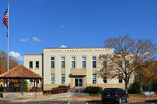
Ozark County is a county in the southern portion of the U.S. state of Missouri. As of the 2020 census, the population was 8,553. The largest city and county seat is Gainesville. The county was organized as Ozark County, named after the Ozark Mountains, on January 29, 1841. It was renamed Decatur County, after Commodore Stephen Decatur, from 1843 to 1845, after which the name Ozark County was restored.

<span class="mw-page-title-main">Osage County, Missouri</span> County in Missouri, United States

Osage County is a county in the central part of the U.S. state of Missouri. As of the 2020 census, the population was 13,274. Its county seat is Linn. The county was organized January 29, 1841, and named from the Osage River.

<span class="mw-page-title-main">Moniteau County, Missouri</span> County in Missouri, United States

Moniteau County is a county located in the U.S. state of Missouri. As of the 2020 United States census, the population was 15,473. Its county seat is California. The county was organized February 14, 1845, and named for the Moniteau Creek. 'Moniteau' is a French spelling of Manitou, Algonquian for the Great Spirit.

<span class="mw-page-title-main">Miller County, Missouri</span> County in Missouri, United States

Miller County is a county located in the U.S. state of Missouri. As of the 2020 United States census, the population was 24,722. Its county seat is Tuscumbia. The county was organized February 6, 1837, and named for John Miller, former U.S. Representative and Governor of Missouri.

<span class="mw-page-title-main">Livingston County, Missouri</span> County in Missouri, United States

Livingston County is a county located in the northwestern portion of the U.S. state of Missouri. As of the 2020 census, the population was 14,557. Its county seat is Chillicothe. The county was organized January 6, 1837, and named for U.S. Secretary of State Edward Livingston.

<span class="mw-page-title-main">Lincoln County, Missouri</span> County in Missouri, United States

Lincoln County is located in the eastern part of the U.S. state of Missouri. As of the 2020 census, the population was 59,574. Its county seat is Troy. The county was founded December 14, 1818, and named for Major General Benjamin Lincoln of the American Revolutionary War.

<span class="mw-page-title-main">Howell County, Missouri</span> County in Missouri, United States

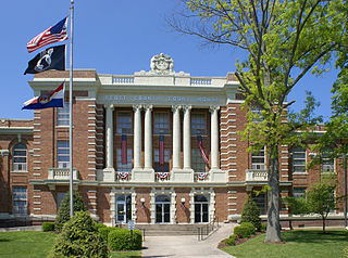
Howell County is in southern Missouri. As of the 2020 census, the population was 39,750. The largest city and county seat is West Plains. The county was officially organized on March 2, 1851, and is named after Josiah Howell, a pioneer settler in the Howell Valley.

<span class="mw-page-title-main">Henry County, Missouri</span> County in Missouri, United States

Henry County is a county located in the western portion of the U.S. state of Missouri. As of the 2020 census, the population was 21,946. Its county seat is Clinton. The county was organized December 13, 1834, as Rives County but was renamed in 1841 for Revolutionary War patriot Patrick Henry. The county originally had been named after William Cabell Rives, who was then serving as a U.S. Senator from Virginia. However, Rives lost popularity in Missouri after he joined the Whig Party.

<span class="mw-page-title-main">Gasconade County, Missouri</span> County in Missouri, United States

Gasconade County is a county located in the east-central portion of the U.S. state of Missouri. As of the 2020 census, the population was 14,794. The county seat has been Hermann since 1842. The county was named after the Gasconade River.

<span class="mw-page-title-main">Franklin County, Missouri</span> County in Missouri, United States

Franklin County is located in the U.S. state of Missouri. At the 2020 census, the population was 104,682. Its county seat is Union. The county was organized in 1818 and is named after Founding Father Benjamin Franklin.

<span class="mw-page-title-main">Camden County, Missouri</span> County in Missouri, United States

Camden County is a county located in the U.S. state of Missouri. As of the 2020 Census, the population was 42,745. Its county seat is Camdenton. The county was organized on January 29, 1841, as Kinderhook County and renamed Camden County in 1843 after Charles Pratt, 1st Earl Camden, Lord Chancellor of the United Kingdom and leader of the British Whig Party. Camden County is also the primary setting of the Netflix show Ozark.

<span class="mw-page-title-main">Warrenton, Missouri</span> City in Missouri, United States

Warrenton is a city and county seat of Warren County, Missouri, United States. The population was 7,880 according to the 2010 Census. Warrenton is an exurb of St. Louis, and is located in the St. Louis Metropolitan Statistical Area. Warrenton's slogan is "A City for All Seasons."

<span class="mw-page-title-main">St. Charles County, Missouri</span> County in Missouri, United States

St. Charles County is in the central eastern part of the U.S. state of Missouri. As of the 2020 census, the population was 405,262, making it Missouri's third-most populous county. Its county seat is St. Charles. The county was organized October 1, 1812, and named for Saint Charles Borromeo, an Italian cardinal.

References

  1. "Warren County, Missouri". United States Census Bureau . Retrieved June 14, 2023.
  2. "Find a County". National Association of Counties. Retrieved June 7, 2011.
  3. Eaton, David Wolfe (1918). How Missouri Counties, Towns and Streams Were Named. The State Historical Society of Missouri. p. 369.
  4. "2010 Census Gazetteer Files". United States Census Bureau. August 22, 2012. Archived from the original on October 21, 2013. Retrieved November 22, 2014.
  5. "U.S. Decennial Census". United States Census Bureau. Retrieved November 22, 2014.
  6. "Historical Census Browser". University of Virginia Library. Retrieved November 22, 2014.
  7. "Population of Counties by Decennial Census: 1900 to 1990". United States Census Bureau. Retrieved November 22, 2014.
  8. "Census 2000 PHC-T-4. Ranking Tables for Counties: 1990 and 2000" (PDF). United States Census Bureau. Archived (PDF) from the original on March 27, 2010. Retrieved November 22, 2014.
  9. "State & County QuickFacts". United States Census Bureau. Retrieved September 14, 2013.
  10. "U.S. Census website". United States Census Bureau . Retrieved January 31, 2008.
  11. "P2 HISPANIC OR LATINO, AND NOT HISPANIC OR LATINO BY RACE – 2020: DEC Redistricting Data (PL 94-171) – Warren County, Missouri".
  12. Leip, David. "Dave Leip's Atlas of U.S. Presidential Elections". uselectionatlas.org. Retrieved March 27, 2018.
  13. The Political Graveyard; Warren County, Missouri
  14. Dave Leip’s Atlas of U.S. Presidential Elections; 1992 Presidential General Election Data Graphs – Missouri
  15. Breeding, Marshall. "Warrenton Branch Library". Libraries.org. Retrieved May 8, 2017.

38°46′N91°10′W / 38.77°N 91.16°W / 38.77; -91.16