Montgomery County, Missouri

Last updated

Montgomery County
Montgomery-County MO Courthouse 20150830 145.jpg
The Montgomery County Courthouse in Montgomery City
Map of Missouri highlighting Montgomery County.svg
Location within the U.S. state of Missouri
Missouri in United States.svg
Missouri's location within the U.S.
Coordinates: 38°56′N91°28′W / 38.94°N 91.47°W / 38.94; -91.47
CountryFlag of the United States.svg United States
StateFlag of Missouri.svg  Missouri
FoundedDecember 14, 1818
Named for Richard Montgomery
Seat Montgomery City
Largest cityMontgomery City
Area
  Total542 sq mi (1,400 km2)
  Land536 sq mi (1,390 km2)
  Water5.8 sq mi (15 km2)  1.1%
Population
 (2020)
  Total11,322
  Density21/sq mi (8.1/km2)
Time zone UTC−6 (Central)
  Summer (DST) UTC−5 (CDT)
Congressional district 3rd
Website mcmo.us

Montgomery County is a county in the east central part of the U.S. state of Missouri. As of the 2020 census, the population was 11,322. [1] Its county seat is Montgomery City. [2] The county was named in honor of Richard Montgomery, an American Revolutionary War general killed in 1775 while attempting to capture Quebec City, Canada.

Contents

The county comprises a portion of the Missouri Rhineland. It is approximately halfway between Columbia and St. Louis.

History

The county has evidence of human habitation from 10,000 years ago, the Archaic period of indigenous Americans. An ancient site was found during archaeological excavations at Graham Cave on the Loutre River.

In the early 19th century, European settlement started at a greater pace, after exploration during previous decades by French trappers and British and American fur traders.

Although the Loutre Island area is commonly associated with the German-founded towns of Rhineland and Starkenburg, established by immigrants of the mid-19th century and later, it was originally settled by Missouri's Anglo-southern settlers from places such as Kentucky or Virginia. Although the southern part of the county is more closely associated with Missouri's Rhineland, its northern part is more associated with Missouri's "Little Dixie" region, earning Montgomery county the nickname "Gateway to Little Dixie".

An early house of worship was a log church, which is still maintained as a chapel. St. Martin's Church is also located in Starkenburg, built in 1873 and listed on the National Register of Historic Places. Above its entrance is the text: "This is the House Of God and the Gate Of Heaven."

Starkenburg is also the site of the Shrine of Our Lady of Sorrows Catholic Church, built in the early 20th century and listed on the NRHP. For further devotions and pilgrimage, the community created an outdoor area for representations of the Stations of the Cross, Mount Calvary and Holy Sepulchre. Starkenburg is located inland from the Missouri River. After the destructive Great Flood of 1993, Rhineland citizens used federal funds to relocate their houses 1.5 miles (2.4 km) inland away from the river.

Geography

According to the U.S. Census Bureau, the county has a total area of 542 square miles (1,400 km2), of which 536 square miles (1,390 km2) is land and 5.8 square miles (15 km2) (1.1%) is water. [3]

Adjacent counties

Major highways

Climate

Montgomery County
Climate chart (explanation)
J
F
M
A
M
J
J
A
S
O
N
D
 
 
58
 
 
1
−8
 
 
86
 
 
3
−6
 
 
104
 
 
13
1
 
 
213
 
 
23
7
 
 
134
 
 
23
13
 
 
109
 
 
26
17
 
 
66
 
 
27
20
 
 
97
 
 
26
19
 
 
94
 
 
24
14
 
 
102
 
 
18
8
 
 
43
 
 
13
4
 
 
74
 
 
4
−4
Average max. and min. temperatures in °C
Precipitation totals in mm
Source: [4]
Imperial conversion
JFMAMJJASOND
 
 
2.3
 
 
34
18
 
 
3.4
 
 
37
21
 
 
4.1
 
 
55
34
 
 
8.4
 
 
73
45
 
 
5.3
 
 
73
55
 
 
4.3
 
 
79
63
 
 
2.6
 
 
81
68
 
 
3.8
 
 
79
66
 
 
3.7
 
 
75
57
 
 
4
 
 
64
46
 
 
1.7
 
 
55
39
 
 
2.9
 
 
39
25
Average max. and min. temperatures in °F
Precipitation totals in inches

Demographics

Historical population
CensusPop.Note
1820 3,074
1830 3,90226.9%
1840 4,37112.0%
1850 5,48925.6%
1860 9,71877.0%
1870 10,4057.1%
1880 16,24956.2%
1890 16,8503.7%
1900 16,571−1.7%
1910 15,604−5.8%
1920 15,233−2.4%
1930 13,011−14.6%
1940 12,442−4.4%
1950 11,555−7.1%
1960 11,097−4.0%
1970 11,000−0.9%
1980 11,5374.9%
1990 11,355−1.6%
2000 12,1366.9%
2010 12,2360.8%
2020 11,322−7.5%
U.S. Decennial Census [5]
1790-1960 [6] 1900-1990 [7]
1990-2000 [8] 2010-2015 [9]

As of the census [10] of 2000, there were 12,136 people, 4,775 households, and 3,337 families residing in the county. The population density was 23 people per square mile (8.9 people/km2). There were 5,726 housing units at an average density of 11 per square mile (4.2/km2). The racial makeup of the county was 95.97% White, 2.04% Black or African American, 0.24% Native American, 0.26% Asian, 0.01% Pacific Islander, 0.21% from other races, and 1.28% from two or more races. Approximately 0.77% of the population were Hispanic or Latino of any race. 39.1% were of German, 18.4% American, 10.2% English and 9.2% Irish ancestry.

There were 4,775 households, out of which 31.30% had children under the age of 18 living with them, 56.90% were married couples living together, 8.60% had a female householder with no husband present, and 30.10% were non-families. 26.30% of all households were made up of individuals, and 13.20% had someone living alone who was 65 years of age or older. The average household size was 2.47 and the average family size was 2.97.

In the county, the population was spread out, with 25.40% under the age of 18, 7.40% from 18 to 24, 26.10% from 25 to 44, 23.90% from 45 to 64, and 17.20% who were 65 years of age or older. The median age was 39 years. For every 100 females there were 98.10 males. For every 100 females age 18 and over, there were 93.70 males.

The median income for a household in the county was $32,772, and the median income for a family was $38,632. Males had a median income of $27,933 versus $19,809 for females. The per capita income for the county was $15,092. About 8.40% of families and 11.80% of the population were below the poverty line, including 15.60% of those under age 18 and 10.60% of those age 65 or over.

2020 Census

Montgomery County Racial Composition [11]
RaceNum.Perc.
White (NH)10,44492.25%
Black or African American (NH)1010.9%
Native American (NH)220.2%
Asian (NH)500.44%
Pacific Islander (NH)50.04%
Other/Mixed (NH)4714.2%
Hispanic or Latino 2292.02%

Community groups

Education

Public schools

Private schools

Public libraries

Communities

Cities

Village

Census-designated places

Other unincorporated places

Politics

Local

The Republican Party controls politics at the local level in Montgomery County. Republicans hold all of the elected positions in the county.

Montgomery County, Missouri
Elected countywide officials
Assessor Jerome P. Overkamp Republican
Circuit Clerk Robyn R. Schmidt Republican
County Clerk Carole L Weeks Republican
Collector Anita L. Sullivan Republican
Commissioner
(Presiding)
Ryan D. Poston Republican
Commissioner
(District 1)
Dave Teeter Republican
Commissioner
(District 2)
Doug Lensing Republican
Coroner David Colbert Republican
Public Administrator Kaley Reagan Republican
Recorder Sheila See Republican
Sheriff Craig Allison Republican
Surveyor Larry P. Bade Republican
Treasurer Lori Steirs Republican

State

Past gubernatorial elections results
Year Republican Democratic Third parties
2016 60.31%3,26136.18% 1,9563.51% 190
2012 53.49%2,84244.01% 2,3382.50% 133
2008 55.34%3,21542.91% 2,4931.76% 102
2004 60.60%3,48038.06% 2,1861.34% 77
2000 54.14%2,85741.65% 2,1984.20% 222
1996 42.23% 2,21855.62%2,9212.15% 113

Montgomery County is part of Missouri's 42nd district in the Missouri House of Representatives and is represented by Bart Korman (R-High Hill).

Missouri House of Representatives — District 42 — Montgomery County (2016)
PartyCandidateVotes%±%
Republican Bart Korman4,802100.00%+28.72
Missouri House of Representatives — District 42 — Montgomery County (2014)
PartyCandidateVotes%±%
Republican Bart Korman2,31671.28%-28.72
Democratic Rod Sturgeon93328.72%+28.72
Missouri House of Representatives — District 42 — Montgomery County (2012)
PartyCandidateVotes%±%
Republican Bart Korman4,645100.00%

Montgomery County is a part of Missouri's 10th District in the Missouri Senate and is currently represented by Jeanie Riddle (R-Fulton).

Missouri Senate — District 10 — Montgomery County (2014)
PartyCandidateVotes%±%
Republican Jeanie Riddle2,42474.42%
Democratic Ed Schieffer83325.58%

Federal

U.S. Senate — Missouri — Montgomery County (2016)
PartyCandidateVotes%±%
Republican Roy Blunt3,40562.86%+14.38
Democratic Jason Kander1,72231.79%-12.46
Libertarian Jonathan Dine1282.36%-4.91
Green Johnathan McFarland841.55%+1.55
Constitution Fred Ryman781.44%+1.44
U.S. Senate — Missouri — Montgomery County (2012)
PartyCandidateVotes%±%
Republican Todd Akin2,55448.48%
Democratic Claire McCaskill2,33144.25%
Libertarian Jonathan Dine3837.27%

Montgomery County is included in Missouri's 3rd congressional district and is represented by Blaine Luetkemeyer (R-St. Elizabeth) in the U.S. House of Representatives.

U.S. House of Representatives — Missouri's 3rd Congressional District — Montgomery County (2016)
PartyCandidateVotes%±%
Republican Blaine Luetkemeyer4,08076.43%+1.37
Democratic Kevin Miller1,07820.19%-0.76
Libertarian Dan Hogan1312.45%-1.54
Constitution Doanita Simmons490.92%+0.92
U.S. House of Representatives — Missouri’s 3rd Congressional District — Montgomery County (2014)
PartyCandidateVotes%±%
Republican Blaine Luetkemeyer2,42675.06%+3.41
Democratic Courtney Denton67720.95%-4.42
Libertarian Steven Hedrick1293.99%+1.01
U.S. House of Representatives — Missouri's 3rd Congressional District — Montgomery County (2012)
PartyCandidateVotes%±%
Republican Blaine Luetkemeyer3,72771.65%
Democratic Eric Mayer1,32025.37%
Libertarian Steven Wilson1552.98%
United States presidential election results for Montgomery County, Missouri [14]
Year Republican Democratic Third party
No.%No.%No.%
2020 4,46577.36%1,20820.93%991.72%
2016 4,12776.02%1,11920.61%1833.37%
2012 3,49065.31%1,74032.56%1142.13%
2008 3,42858.54%2,34740.08%811.38%
2004 3,56361.86%2,14737.27%500.87%
2000 3,10658.57%2,09239.45%1051.98%
1996 2,12440.65%2,27743.58%82415.77%
1992 1,97437.11%2,06338.79%1,28224.10%
1988 2,71456.66%2,06443.09%120.25%
1984 3,26166.16%1,66833.84%00.00%
1980 3,06158.58%2,00738.41%1573.00%
1976 2,66550.83%2,53548.35%430.82%
1972 3,70768.67%1,69131.33%00.00%
1968 2,90353.59%1,89134.91%62311.50%
1964 2,61044.24%3,28955.76%00.00%
1960 3,45455.19%2,80444.81%00.00%
1956 3,44354.76%2,84445.24%00.00%
1952 3,67056.37%2,83543.55%50.08%
1948 2,88950.75%2,79249.04%120.21%
1944 3,52756.20%2,74343.71%60.10%
1940 3,93054.96%3,20544.82%160.22%
1936 3,46849.99%3,45849.85%110.16%
1932 2,60741.77%3,60057.68%340.54%
1928 3,91063.03%2,28536.84%80.13%
1924 3,56353.60%2,93844.19%1472.21%
1920 3,91055.16%3,10343.78%751.06%
1916 2,07950.47%1,98848.26%521.26%
1912 1,69743.75%1,88348.54%2997.71%
1908 2,03848.76%2,07349.59%691.65%
1904 1,97948.40%1,98648.57%1243.03%
1900 1,86646.67%2,00050.03%1323.30%
1896 1,92045.13%2,27253.41%621.46%
1892 1,66543.61%1,91650.18%2376.21%
1888 1,90548.20%1,98950.33%581.47%

See also

Related Research Articles

<span class="mw-page-title-main">Worth County, Missouri</span> County in Missouri, United States

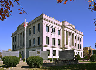
Worth County is a county located in the northwestern portion of the U.S. state of Missouri. As of the 2020 census, the population was 1,973. It is the smallest county in the state in population and, excluding the independent city of St. Louis, the smallest in total area. Its county seat is Grant City. The county was organized February 8, 1861, and named for General William J. Worth, who served in the Mexican–American War. Worth County is also the youngest county in the state.

<span class="mw-page-title-main">Warren County, Missouri</span> County in Missouri, United States

Warren County is a county located in the eastern portion of the U.S. state of Missouri. As of the 2020 census, the population was 35,532. The county is located on the north side of the Missouri River. Its county seat is Warrenton. The county was established on January 5, 1833, and was named for General Joseph Warren, who died in the Battle of Bunker Hill during the American Revolutionary War.

<span class="mw-page-title-main">Ray County, Missouri</span> County in Missouri, United States

Ray County is a county located in the northwestern portion of the U.S. state of Missouri and is part of the Kansas City metropolitan area. As of the 2020 census, the population was 23,158. Its county seat is Richmond. The county was organized November 16, 1820, and named for John Ray, a Missouri state legislator and member of the first state Constitutional Convention.

<span class="mw-page-title-main">Pike County, Missouri</span> County in Missouri, United States

Pike County is a county on the eastern border of the U.S. state of Missouri, bounded by the Mississippi River. As of the 2020 census, the population was 17,587. Its county seat is Bowling Green. Its namesake was a city in middle Kentucky, a region from where many early migrants came. The county was organized December 14, 1818, and named for explorer Zebulon Pike. The folksong "Sweet Betsy from Pike" is generally thought to be associated with Pike County, Missouri.

<span class="mw-page-title-main">Osage County, Missouri</span> County in Missouri, United States

Osage County is a county in the central part of the U.S. state of Missouri. As of the 2020 census, the population was 13,274. Its county seat is Linn. The county was organized January 29, 1841, and named from the Osage River.

<span class="mw-page-title-main">Moniteau County, Missouri</span> County in Missouri, United States

Moniteau County is a county located in the U.S. state of Missouri. As of the 2020 United States census, the population was 15,473. Its county seat is California. The county was organized February 14, 1845, and named for the Moniteau Creek. 'Moniteau' is a French spelling of Manitou, Algonquian for the Great Spirit.

<span class="mw-page-title-main">Maries County, Missouri</span> County in Missouri, United States

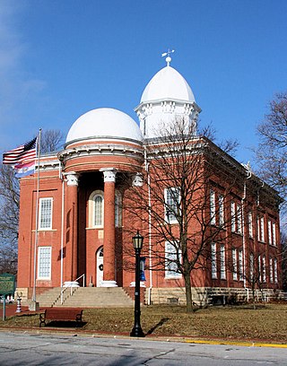
Maries County is a county located in the U.S. state of Missouri. As of the 2020 census, its population was 8,432. Its county seat is Vienna. The county was organized March 2, 1855, and named for the Maries River and Little Maries River. The word "Maries" is derived from the French word marais, which means "marsh, lake, or pond".

<span class="mw-page-title-main">Macon County, Missouri</span> County in Missouri, United States

Macon County is a county located in the northern portion of the U.S. state of Missouri. As of the 2020 census, the population was 15,209. Its county seat is Macon. The county was organized January 6, 1837, and named for Nathaniel Macon, a Revolutionary War hero and North Carolina politician.

<span class="mw-page-title-main">Linn County, Missouri</span> County in Missouri, United States

Linn County is a county located in the northern portion of the U.S. state of Missouri. As of the 2020 census, the population was 11,874. Its county seat is Linneus. The county was organized January 1, 1837, and named after U.S. Senator Lewis F. Linn of Missouri.

<span class="mw-page-title-main">Lawrence County, Missouri</span> County in Missouri, United States

Lawrence County is located in the southwest portion of the U.S. state of Missouri, in the area of the Ozarks. As of the 2020 census, the population was 38,001. Its county seat is Mount Vernon. The county was organized in 1845 and named for James Lawrence, a naval officer from the War of 1812 known for his battle cry, "Don't give up the ship!"

<span class="mw-page-title-main">Howard County, Missouri</span> County in Missouri, United States

Howard County is located in the U.S. state of Missouri, with its southern border formed by the Missouri River. As of the 2020 census, the population was 10,151. Its county seat is Fayette. The county was organized January 23, 1816, and named for Benjamin Howard, the first Governor of the Missouri Territory. Settled originally by migrants from the Upper South, it is part of the region historically known as Little Dixie. It is part of the Columbia, Missouri, metropolitan area.

<span class="mw-page-title-main">Hickory County, Missouri</span> County in Missouri, United States

Hickory County is located in the U.S. state of Missouri. As of the 2020 census, the population was 8,279. Its county seat is Hermitage. The county was organized February 14, 1845, and named after President Andrew Jackson, whose nickname was "Old Hickory." The Pomme de Terre Dam, a Corps of Engineers facility, is located three miles south of Hermitage and forms Lake Pomme de Terre by damming the Pomme de Terre River and Lindley Creek. Truman Reservoir, also a Corps of Engineers facility, floods the Pomme de Terre Reservoir from the northern border of the county southward to the city limits of Hermitage.

<span class="mw-page-title-main">Henry County, Missouri</span> County in Missouri, United States

Henry County is a county located in the western portion of the U.S. state of Missouri. As of the 2020 census, the population was 21,946. Its county seat is Clinton. The county was organized December 13, 1834, as Rives County but was renamed in 1841 for Revolutionary War patriot Patrick Henry. The county originally had been named after William Cabell Rives, who was then serving as a U.S. Senator from Virginia. However, Rives lost popularity in Missouri after he joined the Whig Party.

<span class="mw-page-title-main">Dade County, Missouri</span> County in Missouri, United States

Dade County is a county located in the southwest part of the U.S. state of Missouri. As of the 2020 census, the population was 7,569. Its county seat is Greenfield. The county was organized in 1841 and named after Major Francis L. Dade of Virginia, who was killed in the Second Seminole War in 1835.

<span class="mw-page-title-main">Cole County, Missouri</span> County in Missouri, United States

Cole County is located in the central part of the U.S. state of Missouri. As of the 2020 census, its population was 77,279. Its county seat and largest city is Jefferson City, the state capital. The county was organized November 16, 1820, and named after pioneer William Temple Cole who built Cole's Fort in Boonville.

<span class="mw-page-title-main">Washington, Missouri</span> City in the United States

Washington is a city on the south banks of the Missouri River, 50 miles west of St. Louis, Missouri, and the largest in Franklin County, Missouri, United States. The estimated population in July 2022 was 15,075, which is an increase of 3.97% since the 2020 U.S. census. It is notable for being the "corncob pipe capital of the world," with Missouri Meerschaum located on the riverfront.

<span class="mw-page-title-main">Jonesburg, Missouri</span> City in Missouri, United States

Jonesburg is a city in Montgomery County, Missouri, United States. The population was 726 at the 2020 census.

<span class="mw-page-title-main">Middletown, Missouri</span> City in Missouri, United States

Middletown is a city in Montgomery County, Missouri, United States. The population was 171 at the 2020 census.

<span class="mw-page-title-main">Rhineland, Missouri</span> Village in Missouri, United States

Rhineland is a village in Montgomery County, Missouri, United States. The population was 139 at the 2020 census. Its name came from German immigrants from the river Rhine area.

<span class="mw-page-title-main">Wellsville, Missouri</span> City in Missouri, United States

Wellsville is a city in Montgomery County, Missouri, United States. The population was 998 at the 2020 census.

References

  1. "Explore Census Data". data.census.gov. Retrieved January 11, 2022.
  2. "Find a County". National Association of Counties. Retrieved June 7, 2011.
  3. "2010 Census Gazetteer Files". United States Census Bureau. August 22, 2012. Archived from the original on October 21, 2013. Retrieved November 16, 2014.
  4. "NASA Earth Observations Data Set Index". NASA. Retrieved January 30, 2016.
  5. "U.S. Decennial Census". United States Census Bureau. Retrieved November 16, 2014.
  6. "Historical Census Browser". University of Virginia Library. Retrieved November 16, 2014.
  7. "Population of Counties by Decennial Census: 1900 to 1990". United States Census Bureau. Retrieved November 16, 2014.
  8. "Census 2000 PHC-T-4. Ranking Tables for Counties: 1990 and 2000" (PDF). United States Census Bureau. Retrieved November 16, 2014.
  9. "State & County QuickFacts". United States Census Bureau. Archived from the original on June 7, 2011. Retrieved September 10, 2013.
  10. "U.S. Census website". United States Census Bureau . Retrieved January 31, 2008.
  11. "P2 HISPANIC OR LATINO, AND NOT HISPANIC OR LATINO BY RACE – 2020: DEC Redistricting Data (PL 94-171) – Montgomery County, Missouri".
  12. Breeding, Marshall. "Montgomery City Public Library". Libraries.org. Retrieved May 8, 2017.
  13. Breeding, Marshall. "Wellsville Public Library". Libraries.org. Retrieved May 8, 2017.
  14. Leip, David. "Dave Leip's Atlas of U.S. Presidential Elections". uselectionatlas.org. Retrieved March 25, 2018.

38°56′N91°28′W / 38.94°N 91.47°W / 38.94; -91.47