
Potomac is an unincorporated community and census-designated place in Montgomery County, Maryland, United States. As of the 2020 census, it had a population of 47,018. It is named after the nearby Potomac River. A part of the Washington metropolitan area, many Potomac residents work in nearby Washington, D.C., and Northern Virginia.

Villa Ridge is an unincorporated community and census-designated place (CDP) in Franklin County, Missouri, United States. The population was 2,636 at the 2010 census, up from 2,417 at the 2000 census.

Cedar Hill is an unincorporated community and census-designated place (CDP) in northwest Jefferson County, Missouri, United States. The population was 1,721 at the 2010 census.

High Ridge is an unincorporated community and census-designated place (CDP) in Jefferson County, Missouri, United States. The population was 4,305 at the 2010 census. At 927 feet (283 m) above sea level, High Ridge is the second-highest point in Jefferson County, second only to Sun Ridge, north of Hillsboro, according to data from the House Springs/Hillsboro 7.5 minute topographic quadrangles. The Beaumont Scout Reservation, a property of the Greater St. Louis Area Council, Boy Scouts of America, is 4 miles (6 km) north of High Ridge.

Horine is an unincorporated community and census-designated place (CDP) in Jefferson County, Missouri, United States. The population was 821 at the 2010 census, down from 923 in 2000.

Murphy is a census-designated place (CDP) in Jefferson County, Missouri, United States. The population was 8,690 at the 2010 census, down from 9,048 in 2000.

La Tour or Latour is an unincorporated community in southwestern Johnson County, Missouri, United States. The population was 65 at the 2000 census, at which time it was a village. La Tour disincorporated in 2009, and at the 2010 census the community, now listed as a census-designated place (CDP), had a population of 62.

Montgomery City is a city in and the county seat of Montgomery County, Missouri, United States. The population was 2,811 at the 2020 census.
Philadelphia is an unincorporated community and census-designated place in western Marion County, Missouri, United States. It is located 12 miles (19 km) west of Palmyra on Missouri Route 168. The community is part of the Hannibal Micropolitan Statistical Area.
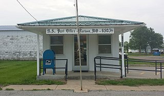
Fortuna is an unincorporated community and census-designated place in Moniteau County, Missouri, United States. As of the 2020 census, the population was 130.
Latham is an unincorporated community and census-designated place in Moniteau County, Missouri, United States. As of the 2020 census, it had a population of 69.
Excello is an unincorporated community and census-designated place (CDP) in southern Macon County, Missouri, United States. As of the 2020 United States census, it had a population of 61.

Skillman is an unincorporated community and census-designated place (CDP) located within Montgomery Township, in Somerset County, in the U.S. state of New Jersey. As of the 2010 United States Census, the CDP's population was 242.
Cherokee Pass is an unincorporated community and census-designated place in Madison County, Missouri, United States. As of the 2020 census, it had a population of 271, up from 235 in 2010.
Lowes Island is a census-designated place (CDP) in Loudoun County, Virginia, United States. The population as of the 2010 United States Census was 10,756. Along with nearby Countryside and Cascades, it is considered one of the three main components of the Potomac Falls community.
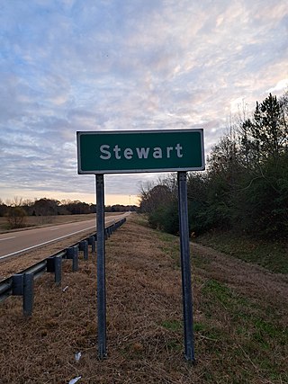
Stewart is a census-designated place and unincorporated community in Montgomery County, Mississippi, United States. As of the 2020 census, it had a population of 99.

Old Jamestown is a census-designated place (CDP) in St. Louis County, Missouri, United States. The population was 19,184 at the 2010 census. Old Jamestown is northwest of the city of St. Louis and borders the Missouri River.
Lake Viking is an unincorporated community and census-designated place (CDP) in Daviess County, Missouri, United States. The population was 486 at the 2020 census.
Leisure Lake is an unincorporated community and census-designated place (CDP) in Grundy County, Missouri, United States. As of the 2020 census, the population was 166.
LaBarque Creek is an unincorporated community and census-designated place (CDP) in Jefferson County, Missouri, United States. Its population was 1,558 as of the 2010 census.


