Related Research Articles
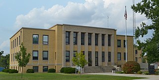
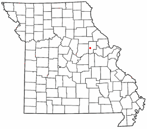
Montgomery County is a county in the east central part of the U.S. state of Missouri. As of the 2020 census, the population was 11,322. Its county seat is Montgomery City. The county was named in honor of Richard Montgomery, an American Revolutionary War general killed in 1775 while attempting to capture Quebec City, Canada.
Mineola is an unincorporated community in western Montgomery County, Missouri, United States. The community is located on Missouri Supplemental Route J and is about one mile south from Interstate 70. Montgomery City is approximately six miles north of the community. It is on the east bank of the Loutre River. Graham Cave within Graham Cave State Park is on the north side of I-70 just north of the community and Mount Horeb Baptist Church is approximately 4.5 miles to the southwest.
Prices Branch is an unincorporated community in Montgomery County, Missouri, United States. The community is located on State Highway JJ and Price's Branch Road and is approximately 13.4 miles (21.6 km) east of Montgomery City.
Garrett is an extinct town in eastern Callaway County, in the U.S. state of Missouri. The community and Garrett Cemetery are on Missouri Route K, one-half mile west of the Callaway-Montgomery county line. The community of Readsville is approximately 3.5 miles to the west and Americus is about 4.5 miles to the east on route K.
Americus is an unincorporated community in Montgomery County, in the U.S. state of Missouri.
Bear Creek is a stream in Montgomery and Warren counties in the U.S. state of Missouri. It is a tributary of the Loutre River.
Camp Creek is a stream in Montgomery, Warren and Lincoln counties in Missouri. It is a tributary of the West Fork of the Cuivre River.
Clear Creek is a stream in Montgomery County in the U.S. state of Missouri. It is a tributary of the Loutre River.
Cole Creek is a stream in Callaway and Montgomery counties in the U.S. state of Missouri. It is a tributary of Prairie Fork of the Loutre River.
Dishwater Creek is a stream in Montgomery County in the U.S. state of Missouri. It is a tributary of the Loutre River.
Dry Fork is a stream in Montgomery County in the U.S. state of Missouri. It is a tributary of the Loutre River.
Egbert is an unincorporated community in Montgomery County, in the U.S. state of Missouri.
Elkhorn Creek is a stream in Montgomery County in the U.S. state of Missouri. It is a tributary of the West Fork of the Cuivre River.
Lick Branch is a stream in Montgomery County in the U.S. state of Missouri. It is a tributary of McIntosh Branch.
Mill Creek is a stream in Montgomery County in the U.S. state of Missouri.
Pinch Creek is a stream in Montgomery County in the U.S. state of Missouri. It is a tributary of the Loutre River.
Quick Creek is a stream in southwest Montgomery County in the U.S. state of Missouri. It is a tributary of the Missouri River.
Starkenburg is an unincorporated community in Montgomery County, in the U.S. state of Missouri.
Whippoorwill Creek is a stream in Montgomery County in the U.S. state of Missouri. It is a tributary of Loutre River.
Loutre Township is an inactive township in Montgomery County, in the U.S. state of Missouri.
References
- ↑ U.S. Geological Survey Geographic Names Information System: Bluffton, Missouri
- ↑ "Montgomery County Place Names, 1928–1945". The State Historical Society of Missouri. Archived from the original on June 24, 2016. Retrieved November 11, 2016.
- ↑ "Post Offices". Jim Forte Postal History. Retrieved November 11, 2016.
Municipalities and communities of Montgomery County, Missouri, United States | ||
|---|---|---|
| Cities |  | |
| Village | ||
| Townships | ||
| CDPs | ||
| Other communities | ||
38°42′29″N91°37′26″W / 38.708°N 91.624°W
| | This Montgomery County, Missouri state location article is a stub. You can help Wikipedia by expanding it. |