Wellsville, Missouri | |
---|---|
Coordinates: 39°04′24″N91°34′09″W / 39.07333°N 91.56917°W | |
Country | United States |
State | Missouri |
County | Montgomery |
Area | |
• Total | 1.54 sq mi (3.99 km2) |
• Land | 1.54 sq mi (3.98 km2) |
• Water | 0.00 sq mi (0.01 km2) |
Elevation | 817 ft (249 m) |
Population | |
• Total | 998 |
• Density | 649.32/sq mi (250.75/km2) |
Time zone | UTC-6 (Central (CST)) |
• Summer (DST) | UTC-5 (CDT) |
ZIP code | 63384 |
Area code | 573 |
FIPS code | 29-78406 [4] |
GNIS feature ID | 2397252 [2] |
Wellsville is a city in Montgomery County, Missouri, United States. The population was 998 at the 2020 census, [5] down from 1,217 in 2010.
Wellsville was platted in 1856, and named after Charles Wells who was the original owner of the land. [6] A post office called Wellsville has been in operation since 1857. [7]
Wellsville is in northwestern Montgomery County, along Missouri Route 19. It is 8 miles (13 km) northwest of Montgomery City, the county seat, and 22 miles (35 km) southeast of the city of Mexico.
According to the U.S. Census Bureau, Wellsville has a total area of 1.54 square miles (3.99 km2), of which 0.002 square miles (0.005 km2), or 0.13%, are water. [1] The city sits on high ground which drains east to White Oak Creek and northwest to Little Coon Creek, both part of the Cuivre River watershed flowing east to the Mississippi River; and southwest to Coal Branch, part of the Loutre River watershed leading south to the Missouri.
Census | Pop. | Note | %± |
---|---|---|---|
1880 | 867 | — | |
1890 | 1,138 | 31.3% | |
1900 | 1,160 | 1.9% | |
1910 | 1,194 | 2.9% | |
1920 | 1,551 | 29.9% | |
1930 | 1,525 | −1.7% | |
1940 | 1,314 | −13.8% | |
1950 | 1,519 | 15.6% | |
1960 | 1,523 | 0.3% | |
1970 | 1,565 | 2.8% | |
1980 | 1,546 | −1.2% | |
1990 | 1,430 | −7.5% | |
2000 | 1,423 | −0.5% | |
2010 | 1,217 | −14.5% | |
2020 | 998 | −18.0% | |
U.S. Decennial Census [8] |
As of the census [9] of 2010, there were 1,217 people, 446 households, and 289 families residing in the city. The population density was 790.3 inhabitants per square mile (305.1/km2). There were 564 housing units at an average density of 366.2 per square mile (141.4/km2). The racial makeup of the city was 95.6% White, 2.8% African American, 0.5% Native American, 0.1% Pacific Islander, 0.2% from other races, and 0.8% from two or more races. Hispanic or Latino of any race were 0.7% of the population.
There were 446 households, of which 34.1% had children under the age of 18 living with them, 47.1% were married couples living together, 11.2% had a female householder with no husband present, 6.5% had a male householder with no wife present, and 35.2% were non-families. 31.2% of all households were made up of individuals, and 15.5% had someone living alone who was 65 years of age or older. The average household size was 2.54 and the average family size was 3.15.
The median age in the city was 41 years. 25.9% of residents were under the age of 18; 6.2% were between the ages of 18 and 24; 22.2% were from 25 to 44; 24.6% were from 45 to 64; and 21.2% were 65 years of age or older. The gender makeup of the city was 49.5% male and 50.5% female.
As of the census [4] of 2000, there were 1,423 people, 533 households, and 346 families residing in the city. The population density was 999.8 inhabitants per square mile (386.0/km2). There were 604 housing units at an average density of 424.4 per square mile (163.9/km2). The racial makeup of the city was 93.18% White, 4.43% African American, 0.21% Native American, 0.07% Asian, 0.35% from other races, and 1.76% from two or more races. Hispanic or Latino of any race were 1.05% of the population.
There were 533 households, out of which 32.6% had children under the age of 18 living with them, 49.9% were married couples living together, 11.4% had a female householder with no husband present, and 34.9% were non-families. 30.4% of all households were made up of individuals, and 15.6% had someone living alone who was 65 years of age or older. The average household size was 2.48 and the average family size was 3.08.
In the city, the population was spread out, with 26.7% under the age of 18, 7.7% from 18 to 24, 25.7% from 25 to 44, 18.3% from 45 to 64, and 21.6% who were 65 years of age or older. The median age was 38 years. For every 100 females, there were 91.0 males. For every 100 females age 18 and over, there were 83.3 males.
The median income for a household in the city was $27,260, and the median income for a family was $32,917. Males had a median income of $28,750 versus $18,750 for females. The per capita income for the city was $11,817. About 14.8% of families and 20.3% of the population were below the poverty line, including 31.7% of those under age 18 and 14.2% of those age 65 or over.
Public education in Wellsville is administered by Wellsville-Middletown R-I School District. [10]
Wellsville has a lending library, the Wellsville Public Library. [11]
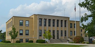
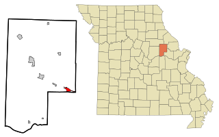
Montgomery County is a county in the east central part of the U.S. state of Missouri. As of the 2020 census, the population was 11,322. Its county seat is Montgomery City. The county was named in honor of Richard Montgomery, an American Revolutionary War general killed in 1775 while attempting to capture Quebec City, Canada.
Coosada is a town in Elmore County, Alabama, United States. At the 2020 census, the population was 1,217. It is part of the Montgomery Metropolitan Statistical Area.
Wellsville is a city in Franklin County, Kansas, United States. As of the 2020 census, the population of the city was 1,953.
Kahoka is a city in and the county seat of Clark County, in the northeast tip of Missouri, United States. As of the 2020 census, its population was 1,961.
Bellflower is a city in Montgomery County, Missouri, United States. The population was 325 at the 2020 census, down from 393 in 2010.
High Hill is a city in Montgomery County, Missouri, United States. The population was 186 at the 2020 census.
Jonesburg is a city in Montgomery County, Missouri, United States. The population was 726 at the 2020 census.
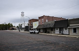
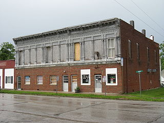
Middletown is a city in Montgomery County, Missouri, United States. The population was 171 at the 2020 census.
New Florence is a city in Montgomery County, Missouri, United States. The population was 641 at the 2020 census, down from 769 in 2010.
Green Ridge is a city located along Route 127 in Pettis County, Missouri, United States. The population was 476 at the 2010 census.
Calverton Park is a city in St. Louis County, Missouri, United States. The population was 1,293 at the 2010 census. The Village of Calverton Park incorporated as the City of Calverton Park in 2014.
Lakeshire is a city in St. Louis County, Missouri, United States. The population was 1,432 at the 2010 census.
Manchester is a city in St. Louis County, Missouri, United States. The population was 18,333 at the 2020 census.
Velda City is a city in St. Louis County, Missouri, United States. The population was 1,420 at the 2010 census.
Winchester is a city in St. Louis County, Missouri, United States. The population was 1,447 at the 2020 census.
Bourbon is a city in Crawford County, Missouri, United States. At the time of the 2010 census, it had a population of 1,632.
Montgomery City is a city in and the county seat of Montgomery County, Missouri, United States. The population was 2,811 at the 2020 census.
Moline Acres is a city in St. Louis County, Missouri, United States. The population was 2,442 at the 2010 census.
Wellsville is a city in Cache County, Utah, United States. The population was 4,060 at the 2020 census. Wellsville is located at the base of the Wellsville mountain range. It is included in the Logan, Utah-Idaho Metropolitan Statistical Area.
Lyndon is a town in Juneau County, Wisconsin, United States. The population was 1,217 at the 2000 census. The unincorporated community of Indian Heights is located in the town.