Douglas County, Missouri

Last updated

Douglas County
Douglas County Court House - Ava, MO.jpg
Douglas County courthouse in Ava
Map of Missouri highlighting Douglas County.svg
Location within the U.S. state of Missouri
Missouri in United States.svg
Missouri's location within the U.S.
Coordinates: 36°56′N92°30′W / 36.93°N 92.5°W / 36.93; -92.5
CountryFlag of the United States.svg United States
StateFlag of Missouri.svg  Missouri
FoundedOctober 19, 1857
Named for Stephen A. Douglas
Seat Ava
Largest cityAva
Area
  Total815 sq mi (2,110 km2)
  Land814 sq mi (2,110 km2)
  Water1.0 sq mi (3 km2)  0.1%
Population
 (2020)
  Total11,578
  Density14/sq mi (5.5/km2)
Time zone UTC−6 (Central)
  Summer (DST) UTC−5 (CDT)
Congressional district 8th

Douglas County is a county located in the south-central portion of the U.S. state of Missouri. As of the 2020 census, the population was 11,578. [1] The county seat and only incorporated community is Ava. [2] The county was officially organized on October 19, 1857, [3] and is named after U.S. Senator Stephen A. Douglas [4] (D-Illinois) and later Democratic presidential candidate.

Contents

History

The bluff above Hunter Creek at Vera Cruz Hunter Creek bluff.JPG
The bluff above Hunter Creek at Vera Cruz

Previously, the county seat was located at Arno, west of Ava. Prior to that, Vera Cruz (formerly called Red Bud) was the county seat. Vera Cruz is located on Bryant Creek, which flows through the middle of the county. The Civil War Battle of Clark's Mill took place near Vera Cruz on November 7, 1862, and resulted in a Confederate victory. [5] After the American Civil War, during a period of general chaos, a group from the western part of the county broke into the Arno courthouse and removed the records back to Vera Cruz. Later in 1871, a new town site was selected, present-day Ava, near the location of the former U.S. Civil War military Post Office, Militia Spring. The location of this new town seemed to satisfy most of the residents of Douglas County to be their point of county government.

Geography

According to the U.S. Census Bureau, the county has a total area of 815 square miles (2,110 km2), of which 814 square miles (2,110 km2) is land and 1.0 square mile (2.6 km2) (0.1%) is water. [6]

Adjacent counties

Roadside park in Mill Hollow adjacent to Route 5 north of Ava Missouri Route 5 Roadside Park.jpg
Roadside park in Mill Hollow adjacent to Route 5 north of Ava

Major highways

National protected area

Demographics

Historical population
CensusPop.Note
1860 2,414
1870 3,91562.2%
1880 7,75398.0%
1890 14,11182.0%
1900 16,80219.1%
1910 16,664−0.8%
1920 15,436−7.4%
1930 13,959−9.6%
1940 15,60011.8%
1950 12,638−19.0%
1960 9,653−23.6%
1970 9,268−4.0%
1980 11,59425.1%
1990 11,8762.4%
2000 13,08410.2%
2010 13,6844.6%
2020 11,578−15.4%
U.S. Decennial Census [7]
1790-1960 [8] 1900-1990 [9]
1990-2000 [10] 2010-2015 [11]

As of the census [12] of 2000, there were 13,084 people, 5,201 households, and 3,671 families residing in the county. The population density was 16 people per square mile (6.2 people/km2). There were 5,919 housing units at an average density of 7 units per square mile (2.7/km2). The racial makeup of the county was 96.86% White, 0.11% Black or African American, 0.95% Native American, 0.21% Asian, 0.02% Pacific Islander, 0.17% from other races, and 1.69% from two or more races. Approximately 0.84% of the population were Hispanic or Latino of any race. Among the major first ancestries reported in Douglas County are 31.3% American, 13.2% English, 12.3% German, and 9.7% Irish.

There were 5,201 households, out of which 30.10% had children under the age of 18 living with them, 60.00% were married couples living together, 7.20% had a female householder with no husband present, and 29.40% were non-families. 26.10% of all households were made up of individuals, and 13.00% had someone living alone who was 65 years of age or older. The average household size was 2.49 and the average family size was 2.99.

In the county, the population was spread out, with 25.80% under the age of 18, 7.00% from 18 to 24, 24.50% from 25 to 44, 25.60% from 45 to 64, and 17.10% who were 65 years of age or older. The median age was 40 years. For every 100 females there were 96.60 males. For every 100 females age 18 and over, there were 93.30 males.

The median income for a household in the county was $31,335, and the median income for a family was $36,648. Males had a median income of $22,706 versus $17,060 for females. The per capita income for the county was $16,710. About 12.90% of families and 17.50% of the population were below the poverty line, including 19.80% of those under age 18 and 18.20% of those age 65 or over.

Religion

According to the Association of Religion Data Archives County Membership Report (2000), Douglas County is a part of the Bible Belt with evangelical Protestantism being the majority religion. The most predominant denominations among residents in Douglas County who adhere to a religion are Southern Baptists (22.95%), Church of the Nazarene (16.28%), and Mormons (13.70%).

Established in 1950, a Trappist monastery, Assumption Abbey, can be found nestled on 3,000 acres in the Ozark hills. An associated Friary, Our Lady of the Angels, is located nearby. Both facilities have overnight rooms available to be utilized by the public for a small fee in order to find a place of solace and quiet reflection.

2020 Census

Douglas County Racial Composition [13]
RaceNum.Perc.
White (NH)10,60291.6%
Black or African American (NH)350.3%
Native American (NH)740.64%
Asian (NH)240.21%
Pacific Islander (NH)00%
Other/Mixed (NH)6045.22%
Hispanic or Latino 2392.1%

Education

Of adults 25 years of age and older in Douglas County, 69.7% possess a high school diploma or higher while 9.9% hold a bachelor's degree or higher as their highest educational attainment.

Public schools

Ava High School in Ava, Missouri Ava High School 2.jpg
Ava High School in Ava, Missouri

Private schools

Public libraries

Politics

Local

Douglas County, Missouri
Elected countywide officials
Assessor Alicia Miller-Degase Republican
Circuit Clerk Kim Hathcock Republican
County Clerk Karry Davis Republican
Collector Laura Stillings Republican
Commissioner
(Presiding)
Larry Pueppke Republican
Commissioner
(District 1)
Richard Mitchell Republican
Commissioner
(District 2)
Danny Dry Republican
Coroner Rick Miller Republican
Prosecuting Attorney Roger Wall Republican
Public Administrator Linda Coonts Republican
Recorder Tina Boyd Republican
Sheriff Chris Degase Republican
Surveyor Andy Daniels Democratic
Treasurer Theresa Miller Republican

The Republican party holds most of the elected positions in the county, though this has not always been the case; in the early 1900s, Douglas County was primarily Democratic.

State

Past Gubernatorial Elections Results
Year Republican Democratic Third Parties
2020 82.81%5,77315.01% 1,0462.18% 152
2016 72.34%4,81824.13% 1,6073.53% 235
2012 59.43%3,86936.97% 2,4073.59% 234
2008 45.27% 3,01448.95%3,2595.78% 385
2004 70.08%4,41228.40% 1,7881.52% 96
2000 63.53%3,31734.73% 1,8131.74% 91
1996 61.03%3,14536.06% 1,8582.91% 150
1992 57.14%3,20342.86% 2,4030.00% 0
1988 74.63%3,67124.90% 1,2250.47% 23
1984 75.00%3,84625.00% 1,2820.00% 0
1980 60.76%3,15138.78% 2,0110.46% 24
1976 63.51%2,92436.21% 1,6670.28% 13
1972 67.00%3,35032.90% 1,6450.10% 5
1968 59.75%2,42040.25% 1,6300.00% 0
1964 58.64%2,21741.16% 1,5510.00% 0
1960 73.68%3,24226.32% 1,1580.00% 0

All of Douglas County is a part of Missouri's 155th District

Missouri House of Representatives — District 155 — Douglas County (2016)
PartyCandidateVotes%±%
Republican Lyle Rowland5,641100.00%
Missouri House of Representatives — District 155 — Douglas County (2014)
PartyCandidateVotes%±%
Republican Lyle Rowland2,424100.00%
Missouri House of Representatives — District 155 — Douglas County (2012)
PartyCandidateVotes%±%
Republican Lyle Rowland5,360100.00%

All of Douglas County is a part of Missouri's 33rd District.

Missouri Senate — District 33 — Douglas County (2016)
PartyCandidateVotes%±%
Republican Mike Cunningham5,713100.00%
Missouri Senate — District 33 — Douglas County (2012)
PartyCandidateVotes%±%
Republican Mike Cunningham5,478100.00%

Federal

Missouri's two U.S. Senators are Republicans Josh Hawley and Eric Schmitt

U.S. Senate — Missouri — Douglas County (2016)
PartyCandidateVotes%±%
Republican Roy Blunt4,75371.31%+17.76
Democratic Jason Kander1,55623.35%-14.71
Libertarian Jonathan Dine1742.61%-5.78
Green Johnathan McFarland811.22%+1.22
Constitution Fred Ryman1011.52%+1.52
U.S. Senate — Missouri — Douglas County (2012)
PartyCandidateVotes%±%
Republican W. Todd Akin3,49853.55%
Democratic Claire McCaskill2,48638.06%
Libertarian Jonathan Dine5488.39%

All of Douglas County is included in Missouri's 8th Congressional District and is currently represented by Jason T. Smith of Salem in the U.S. House of Representatives. Smith won a special election on Tuesday, June 4, 2013, to complete the remaining term of former U.S. Representative Jo Ann Emerson of Cape Girardeau. Emerson announced her resignation a month after being reelected with over 70 percent of the vote in the district. She resigned to become CEO of the National Rural Electric Cooperative.

U.S. House of Representatives — Missouri's 8th Congressional District — Douglas County (2016)
PartyCandidateVotes%±%
Republican Jason T. Smith5,31382.31%+7.76
Democratic Dave Cowell94414.62%-1.07
Libertarian Jonathan Shell1983.07%+0.59
U.S. House of Representatives — Missouri's 8th Congressional District — Douglas County (2014)
PartyCandidateVotes%±%
Republican Jason T. Smith2,13374.55%-0.67
Democratic Barbara Stocker44915.69%-2.54
Libertarian Rick Vandeven712.48%+0.84
Constitution Doug Enyart642.24%-2.67
Independent Terry Hampton1445.03%+5.03
U.S. House of Representatives — Missouri's 8th Congressional District — Special Election — Douglas County (2013)
PartyCandidateVotes%±%
Republican Jason T. Smith1,01175.22%-2.20
Democratic Steve Hodges24518.23%+0.75
Libertarian Bill Slantz221.64%-3.45
Constitution Doug Enyart664.91%+4.91
U.S. House of Representatives — Missouri's 8th Congressional District — Douglas County (2012)
PartyCandidateVotes%±%
Republican Jo Ann Emerson4,94277.42%
Democratic Jack Rushin1,11617.48%
Libertarian Rick Vandeven3255.09%

Political culture

United States presidential election results for Douglas County, Missouri [15]
Year Republican Democratic Third party
No.%No.%No.%
2020 5,89884.26%1,01614.51%861.23%
2016 5,48682.30%98414.76%1962.94%
2012 4,64970.90%1,71026.08%1983.02%
2008 4,40565.63%2,14031.88%1672.49%
2004 4,49871.09%1,74127.52%881.39%
2000 3,59968.15%1,54629.27%1362.58%
1996 2,60150.17%1,74433.64%83916.18%
1992 2,56944.35%2,12636.71%1,09718.94%
1988 3,22564.85%1,73534.89%130.26%
1984 3,66270.45%1,53629.55%00.00%
1980 3,44065.50%1,67731.93%1352.57%
1976 2,65256.82%1,98142.45%340.73%
1972 3,77375.73%1,20924.27%00.00%
1968 2,83667.11%97823.14%4129.75%
1964 2,28058.87%1,59341.13%00.00%
1960 3,61178.08%1,01421.92%00.00%
1956 2,91071.98%1,13328.02%00.00%
1952 4,05181.49%90918.29%110.22%
1948 2,73469.85%1,16329.71%170.43%
1944 3,57082.45%74617.23%140.32%
1940 4,87077.90%1,35021.59%320.51%
1936 4,03165.15%2,11834.23%380.61%
1932 2,36253.50%1,92243.53%1312.97%
1928 3,75884.00%68115.22%350.78%
1924 2,61769.16%90924.02%2586.82%
1920 3,32782.09%57714.24%1493.68%
1916 1,73065.26%73727.80%1846.94%
1912 85530.56%56620.23%1,37749.21%
1908 1,92264.84%69923.58%34311.57%
1904 1,83071.91%43717.17%27810.92%
1900 1,70557.72%85829.05%39113.24%
1896 1,59848.32%1,70051.41%90.27%
1892 1,30953.23%32813.34%82233.43%
1888 1,30654.03%47719.74%63426.23%

Douglas County is, like most other counties located in the GOP bastion of Southwest Missouri, a Republican stronghold in presidential elections. No Democratic presidential nominee has won Douglas County since William Jennings Bryan in 1896, and no other nominee has done so since 1864. [16] While statewide elections tend to be closer throughout the state, this is not the case in Douglas County, as no Democratic gubernatorial nominee had won the county in over 50 years until Governor Jay Nixon's narrow pluralistic win in 2008. Furthermore, with all local elected offices being held by Republicans, voters have kept the traditionally Republican dominance alive in Douglas County.

Like most rural areas throughout the Bible Belt in Southwest Missouri, voters in Douglas County traditionally adhere to socially and culturally conservative principles which tend to strongly influence their Republican leanings. In 2004, Missourians voted on a constitutional amendment to define marriage as the union between a man and a woman—it overwhelmingly passed Douglas County with 85.78 percent of the vote. The initiative passed the state with 71 percent of support from voters as Missouri became the first state to ban same-sex marriage. In 2006, Missourians voted on a constitutional amendment to fund and legalize embryonic stem cell research in the state—it failed in Douglas County with 59.36 percent voting against the measure. The initiative narrowly passed the state with 51 percent of support from voters as Missouri became one of the first states in the nation to approve embryonic stem cell research. Despite Douglas County's longstanding tradition of supporting socially conservative platforms, voters in the county have a penchant for advancing populist causes like increasing the minimum wage. In 2006, Missourians voted on a proposition (Proposition B) to increase the minimum wage in the state to $6.50 an hour—it passed Douglas County with 71.97 percent of the vote. The proposition strongly passed every single county in Missouri with 78.99 percent voting in favor as the minimum wage was increased to $6.50 an hour in the state. During the same election, voters in five other states also strongly approved increases in the minimum wage.

Communities

The county has only one incorporated town: Ava, the county seat. Also, a number of current and historic communities are present: [17] [18]

See also

Related Research Articles

<span class="mw-page-title-main">Wright County, Missouri</span> County in Missouri, United States

Wright County is a county located in the southern portion of the U.S. state of Missouri. As of the 2020 census, the population was 18,188. Its county seat is Hartville. The county was officially organized on January 29, 1841, and is named after Silas Wright, a former Congressman, U.S. Senator and Governor of New York.

<span class="mw-page-title-main">Webster County, Missouri</span> County in Missouri, United States

Webster County is a county located in the U.S. state of Missouri. As of the 2020 census, the population was 39,085. Its county seat is Marshfield. The county was organized in 1855 and named for U.S. Senator and U.S. Secretary of State Daniel Webster.

<span class="mw-page-title-main">Wayne County, Missouri</span> County in Missouri, United States

Wayne County is a county located in the Ozark foothills in the U.S. state of Missouri. As of the 2020 census, the population was 10,974. The county seat is Greenville. The county was officially organized on December 11, 1818, and is named after General "Mad" Anthony Wayne, who served in the American Revolution. As of August 28, 2023, Wayne County is designated the UFO Capital of Missouri, along with the city of Piedmont.

<span class="mw-page-title-main">Warren County, Missouri</span> County in Missouri, United States

Warren County is a county located in the eastern portion of the U.S. state of Missouri. As of the 2020 census, the population was 35,532. The county is located on the north side of the Missouri River. Its county seat is Warrenton. The county was established on January 5, 1833, and was named for General Joseph Warren, who died in the Battle of Bunker Hill during the American Revolutionary War.

<span class="mw-page-title-main">Texas County, Missouri</span> County in Missouri, United States

Texas County is a county located in the southern portion of the U.S. state of Missouri. As of the 2020 census, the population was 24,487. Its county seat is Houston. The county was organized in 1843 as Ashley County. Its name was changed in 1845 to Texas County, after the Republic of Texas. The 2010 U.S. Census indicates that the county was the center of population for the United States.

<span class="mw-page-title-main">Taney County, Missouri</span> County in Missouri, United States

Taney County is a county in the southwestern portion of the U.S. state of Missouri. As of the 2020 census, the population was 56,066. Its county seat is Forsyth. It is included in the Branson, Missouri, Micropolitan Statistical Area.

<span class="mw-page-title-main">Stone County, Missouri</span> County in Missouri, United States

Stone County is located in the southwestern portion of the U.S. state of Missouri. As of the 2020 census, the population was 31,076. Its county seat is Galena.

<span class="mw-page-title-main">Stoddard County, Missouri</span> County in Missouri, United States

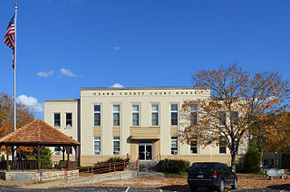
Stoddard County is a county located in the southeastern portion of the U.S. state of Missouri. As of the 2020 census, the population was 28,672. The county seat is Bloomfield. The county was officially organized on January 2, 1835, and is named for Amos Stoddard, the first American commandant of Upper Louisiana.

<span class="mw-page-title-main">Shannon County, Missouri</span> County in Missouri, United States

Shannon County is a county in the southern portion of the U.S. state of Missouri. As of the 2020 census, the population was 7,031. Its county seat is Eminence. The county was officially organized on January 29, 1841, and was named in honor of George F. "Peg-Leg" Shannon, a member of the Lewis and Clark Expedition. It is the second-largest county by area in Missouri.

<span class="mw-page-title-main">Ripley County, Missouri</span> County in Missouri, United States

Ripley County is a county in the Ozarks of Missouri. At the 2020 census, it had a population of 10,679. The largest city and county seat is Doniphan. The county was officially organized on January 5, 1833, and is named after Brigadier General Eleazer Wheelock Ripley, a soldier who served with distinction in the War of 1812.

<span class="mw-page-title-main">Reynolds County, Missouri</span> County in Missouri, United States

Reynolds County is a county located in the Ozark Foothills Region in the Lead Belt of Missouri. As of the 2020 census, the population was 6,096. Its county seat is Centerville. The county was officially organized on February 25, 1845, and was named in honor of former Governor of Missouri Thomas Reynolds.

<span class="mw-page-title-main">Ozark County, Missouri</span> County in Missouri, United States

Ozark County is a county in the southern portion of the U.S. state of Missouri. As of the 2020 census, the population was 8,553. The largest city and county seat is Gainesville. The county was organized as Ozark County, named after the Ozark Mountains, on January 29, 1841. It was renamed Decatur County, after Commodore Stephen Decatur, from 1843 to 1845, after which the name Ozark County was restored.

<span class="mw-page-title-main">Oregon County, Missouri</span> County in Missouri

Oregon County is a county located in the southern portion of the U.S. state of Missouri. As of the 2020 census, the population was 8,635. Its county seat is Alton. The county was officially organized on February 14, 1845, and was named for the Oregon Territory in the northwestern United States.

<span class="mw-page-title-main">Iron County, Missouri</span> County in Missouri, United States

Iron County is a county located in the Lead Belt region in the U.S. state of Missouri. As of the 2020 census, the population was 9,537. The largest city and county seat is Ironton. Iron County was officially organized on February 17, 1857, and was named after the abundance of iron ore found within its borders.

<span class="mw-page-title-main">Howell County, Missouri</span> County in Missouri, United States

Howell County is in southern Missouri. As of the 2020 census, the population was 39,750. The largest city and county seat is West Plains. The county was officially organized on March 2, 1851, and is named after Josiah Howell, a pioneer settler in the Howell Valley.

<span class="mw-page-title-main">Gentry County, Missouri</span> County in Missouri, United States

Gentry County is a county located in the northwestern portion of the U.S. state of Missouri. As of the 2020 census, the population was 6,162. Its county seat is Albany. The county was organized February 14, 1841 and named for Colonel Richard Gentry of Boone County, who fell in the Seminole War in 1837.

<span class="mw-page-title-main">Gasconade County, Missouri</span> County in Missouri, United States

Gasconade County is a county located in the east-central portion of the U.S. state of Missouri. As of the 2020 census, the population was 14,794. The county seat has been Hermann since 1842. The county was named after the Gasconade River.

<span class="mw-page-title-main">Franklin County, Missouri</span> County in Missouri, United States

Franklin County is located in the U.S. state of Missouri. At the 2020 census, the population was 104,682. Its county seat is Union. The county was organized in 1818 and is named after Founding Father Benjamin Franklin.

<span class="mw-page-title-main">Dunklin County, Missouri</span> County in Missouri, United States

Dunklin County is located in the Bootheel of the U.S. state of Missouri. As of the 2020 census, the population was 28,283. The largest city and county seat is Kennett. The county was officially organized on February 14, 1845, and is named in honor of Daniel Dunklin, a Governor of Missouri who died the year before the county was organized.

<span class="mw-page-title-main">Christian County, Missouri</span> County in Missouri, United States

Christian County is located in the southwestern part of the U.S. state of Missouri. As of the 2020 census, its population was 88,842. Its county seat is Ozark. The county was organized in 1859 and is named after Christian County, Kentucky, which in turn is named for William Christian, a Kentucky soldier of the American Revolutionary War.

References

  1. "Explore Census Data". data.census.gov. Retrieved January 12, 2022.
  2. "Find a County". National Association of Counties. Archived from the original on May 31, 2011. Retrieved June 7, 2011.
  3. Eaton, David Wolfe (1916). How Missouri Counties, Towns and Streams Were Named. The State Historical Society of Missouri. pp.  165.
  4. Gannett, Henry (1905). The Origin of Certain Place Names in the United States. Govt. Print. Off. pp.  108.
  5. U.S. National Park Service CWSAC Battle Summary Archived September 24, 2008, at the Wayback Machine
  6. "2010 Census Gazetteer Files". United States Census Bureau. August 22, 2012. Archived from the original on July 9, 2013. Retrieved November 15, 2014.
  7. "U.S. Decennial Census". United States Census Bureau. Retrieved November 15, 2014.
  8. "Historical Census Browser". University of Virginia Library. Retrieved November 15, 2014.
  9. "Population of Counties by Decennial Census: 1900 to 1990". United States Census Bureau. Retrieved November 15, 2014.
  10. "Census 2000 PHC-T-4. Ranking Tables for Counties: 1990 and 2000" (PDF). United States Census Bureau. Archived (PDF) from the original on March 27, 2010. Retrieved November 15, 2014.
  11. "State & County QuickFacts". United States Census Bureau. Archived from the original on June 7, 2011. Retrieved September 8, 2013.
  12. "U.S. Census website". United States Census Bureau . Retrieved January 31, 2008.
  13. "P2 HISPANIC OR LATINO, AND NOT HISPANIC OR LATINO BY RACE – 2020: DEC Redistricting Data (PL 94-171) – Douglas County, Missouri".
  14. Breeding, Marshall. "Douglas County Public Library". Libraries.org. Retrieved May 8, 2017.
  15. Leip, David. "Dave Leip's Atlas of U.S. Presidential Elections". uselectionatlas.org. Retrieved March 25, 2018.
  16. Menendez, Albert J.; The Geography of Presidential Elections in the United States, 1868-2004, pp. 31, 239 ISBN   0786422173
  17. Moser, Arthur Paul; A Directory of Towns, Villages, and Hamlets Past and Present of Douglas County, Missouri
  18. Post Offices in Douglas County, MO

Further reading

36°56′N92°30′W / 36.93°N 92.50°W / 36.93; -92.50