McDonald County, Missouri

Last updated

McDonald County
OLD MCDONALD COUNTY COURTHOUSE, PINEVILLE, MO.jpg
Map of Missouri highlighting McDonald County.svg
Location within the U.S. state of Missouri
Missouri in United States.svg
Missouri's location within the U.S.
Coordinates: 36°37′N94°21′W / 36.62°N 94.35°W / 36.62; -94.35
CountryFlag of the United States.svg United States
StateFlag of Missouri.svg  Missouri
FoundedMarch 3, 1849
Named for Sergeant Alexander McDonald, a soldier in the American Revolutionary War
Seat Pineville
Largest city Anderson
Area
  Total540 sq mi (1,400 km2)
  Land539 sq mi (1,400 km2)
  Water0.2 sq mi (0.5 km2)  0.04%
Population
 (2020)
  Total23,303
  Density43/sq mi (17/km2)
Time zone UTC−6 (Central)
  Summer (DST) UTC−5 (CDT)
Congressional district 7th
Website mcdonaldcountymo.gov
McDonald County courthouse in Pineville McDonald County MO Courthouse 20151022-106.jpg
McDonald County courthouse in Pineville

McDonald County is a county located in the southwestern corner of the U.S. state of Missouri. As of the 2020 census, the population was 23,303. [1] Its county seat is Pineville. [2] The county was organized in 1849 and named for Sergeant Alexander McDonald, a soldier in the American Revolutionary War. [3] The county has three sites on the National Register of Historic Places, including the Old McDonald County Courthouse and the Powell Bridge.

Contents

Geography

According to the U.S. Census Bureau, the county has a total area of 540 square miles (1,400 km2), of which 539 square miles (1,400 km2) is land and 0.2 square miles (0.52 km2) (0.04%) is water. [4]

Adjacent counties

Major highways

Demographics

Historical population
CensusPop.Note
1850 2,236
1860 4,00879.2%
1870 3,756−6.3%
1880 7,816108.1%
1890 11,28344.4%
1900 13,57420.3%
1910 13,539−0.3%
1920 12,690−6.3%
1930 13,9369.8%
1940 15,74913.0%
1950 14,144−10.2%
1960 11,798−16.6%
1970 12,3574.7%
1980 14,91720.7%
1990 16,93813.5%
2000 21,68128.0%
2010 23,0836.5%
2020 23,3031.0%
U.S. Decennial Census [5]
1790-1960 [6] 1900-1990 [7]
1990-2000 [8] 2010 [9]

As of the census [10] of 2000, there were 21,681 people, 8,113 households, and 5,865 families residing in the county. The population density was 40 people per square mile (15 people/km2). There were 9,287 housing units at an average density of 17 units per square mile (6.6/km2). The racial makeup of the county was 89.66% White, 0.18% Black or African American, 2.88% Native American, 0.14% Asian, 0.14% Pacific Islander, 3.70% from other races, and 3.30% from two or more races. Approximately 9.36% of the population were Hispanic or Latino of any race. 28.0% were of American, 11.5% German, 10.5% Irish and 6.6% English ancestry.

There were 8,113 households, out of which 35.70% had children under the age of 18 living with them, 57.60% were married couples living together, 9.60% had a female householder with no husband present, and 27.70% were non-families. 23.30% of all households were made up of individuals, and 9.10% had someone living alone who was 65 years of age or older. The average household size was 2.65 and the average family size was 3.11.

In the county, the population was spread out, with 28.90% under the age of 18, 8.70% from 18 to 24, 28.60% from 25 to 44, 22.60% from 45 to 64, and 11.30% who were 65 years of age or older. The median age was 34 years. For every 100 females, there were 102.60 males. For every 100 females age 18 and over, there were 99.50 males.

The median income for a household in the county was $27,010, and the median income for a family was $31,530. Males had a median income of $23,434 versus $18,157 for females. The per capita income for the county was $13,175. About 15.60% of families and 20.70% of the population were below the poverty line, including 28.60% of those under age 18 and 17.20% of those age 65 or over.

2020 Census

McDonald County Racial Composition [11]
RaceNum.Perc.
White (NH)16,66771.5%
Black or African American (NH)4211.8%
Native American (NH)4932.12%
Asian (NH)3761.61%
Pacific Islander (NH)8683.72%
Other/Mixed (NH)1,6607.12%
Hispanic or Latino 2,81812.1%

Education

Public schools

History of McDonald County R-I School District

The present McDonald County R-I School District is the result of consolidations of several county school districts. The first two school districts to consolidate were the Pineville and Anderson school districts. This was the first step in what was a long-range plan to combine all of the remaining high schools in the county with the exception of the Goodman School District which would become a part of the Neosho school system. The plan for the Pineville–Anderson consolidation was approved and the state offered a $50,000 matching grant for the building of a new high school. If the remaining high schools were to have joined, an additional $200,000 in matching grants would have been recurred.

The first consolidated class from Pineville and Anderson was the Class of 1966. David Alumbaugh was a member of that class and remembers it was the class that elected the school mascot as the mustang and the school colors of red and black. There was not a new high school so each town maintained a high school faculty but all activities including athletics were combined. When asked what the mood of the people in Pineville was concerning the school consolidation, Alumbaugh said, "I don't remember it being a great deal; most people considered it inevitable it was going to happen sooner or later." It was something that could not be stopped, according to Larry Warner who taught during the first year (1966) at the Pineville campus and then at the new high school in Anderson its next year. "It was something that was really needed. The faculty at the old Pineville High School was not very good either at the end of their careers or just beginning. The kids got along fine at the new school but it was the parents who fought."

The next school district to consider joining Pineville and Anderson was the Noel School District. Noel Lawmen had a serious concern on where the new high school, which would serve all students, would be located. The proposed site was about a mile east of the city of Anderson at the junction of Highway 76 and then new Highway 71. The Noel patrons wanted a site more close to the center of the county which would be just north of the Indian River Bridge at the city of Lanagan. The Noel School Board sent a letter to the Missouri Department of Elementary & Secondary Education calling for a vote of the people of McDonald County on the site but this didn't happen. The reasoning for there not being a countywide vote couldn't be found, but the proposed new high school site had already been approved by the Missouri Department of Education. ...... Once a school district was asked to be included in the reorganized district the people of the district asked to be included and the people of the reorganized district both voted. What this meant was that the people of Pineville and Anderson could vote in other districts even if that other district's patrons didn't want to come into the reorganized district, they had to. This led to many of the hard feelings that last even today in McDonald County about the school consolidation. With the addition of Noel to the reorganization there were only the high schools of Goodman, Rocky Comfort and Southwest City left. The school district of Goodman decided to join the school district of Neosho. This left Southwest City with its school population of 89 and Rocky Comfort with its high school population of 107 as the only other two schools left in the county. Southwest City, located only miles from the Arkansas and Oklahoma borders, had no other choice. There were no Missouri schools close to it so it asked and was voted into the reorganized plan. Rocky Comfort is located on the eastern edge of McDonald County and would have been much closer to reorganize with the town of Wheaton in Barry County. Rocky Comfort ended up joining the reorganization of the McDonald County schools.

Public libraries

Communities

Cities and Towns

Unincorporated Communities

Politics

Local

The Republican Party predominantly controls politics at the local level in McDonald County. Republicans hold all but one of the elected positions in the county.

McDonald County, Missouri
Elected countywide officials
Assessor Sue Ann Stokes Republican
Circuit Clerk Jennifer Mikeska Republican
County Clerk Barbara Williams Republican
Collector Brenda Gordon Republican
Commissioner
(Presiding)
Bryan Hall Republican
Commissioner
(District 1)
Sam Gaskill Republican
Commissioner
(District 2)
David Holloway Republican
Coroner BJ Goodwin Republican
Prosecuting Attorney Jonathan Pierce Republican
Public Administrator Donna Underwood Republican
Recorder Michelle Barker Republican
Sheriff Michael S. Hall Republican
Surveyor Travis Green Republican
Treasurer Joye Helm Republican

State

Past Gubernatorial Elections Results
Year Republican Democratic Third Parties
2016 72.55%5,91522.73% 1,8534.72% 385
2012 62.26%4,82333.10% 2,5644.64% 359
2008 59.74%4,76636.63% 2,9223.63% 290
2004 73.36%5,62224.71% 1,8941.94% 148
2000 64.92%4,21632.14% 2,0872.94% 191
1996 54.46%3,29741.89% 2,5363.65% 221

All of McDonald County is a part of Missouri's 159th district in the Missouri House of Representatives and is represented by Bill Lant (R-Pineville).

Missouri House of Representatives — District 159 — McDonald County (2016)
PartyCandidateVotes%±%
Republican Bill Lant7,290100.00%
Missouri House of Representatives — District 159 — McDonald County (2014)
PartyCandidateVotes%±%
Republican Bill Lant3,346100.00%
Missouri House of Representatives — District 159 — McDonald County (2012)
PartyCandidateVotes%±%
Republican Bill Lant6,621100.00%

All of McDonald County is a part of Missouri's 29th District and is currently represented in the Missouri Senate by David Sater (R-Cassville).

Missouri Senate — District 29 — McDonald County (2016)
PartyCandidateVotes%±%
Republican David Sater7,176100.00%
Missouri Senate — District 29 — McDonald County (2012)
PartyCandidateVotes%±%
Republican David Sater6,575100.00%

Federal

U.S. Senate — Missouri — McDonald County (2016)
PartyCandidateVotes%±%
Republican Roy Blunt5,81271.10%+11.12
Democratic Jason Kander1,79321.94%-12.04
Libertarian Jonathan Dine2583.16%-2.88
Constitution Fred Ryman1702.08%+2.08
Green Johnathan McFarland1411.72%+1.72
U.S. Senate — Missouri — McDonald County (2012)
PartyCandidateVotes%±%
Republican Todd Akin4,66759.98%
Democratic Claire McCaskill2,64433.98%
Libertarian Jonathan Dine4706.04%

All of McDonald County is included in Missouri's 7th Congressional District and is represented by Billy Long (R-Springfield) in the U.S. House of Representatives.

U.S. House of Representatives — Missouri's 7th Congressional District — McDonald County (2016)
PartyCandidateVotes%±%
Republican Billy Long6,27177.92%+0.42
Democratic Genevieve Williams1,42817.74%-0.14
Libertarian Benjamin T. Brixey3494.34%-0.28
U.S. House of Representatives — Missouri's 7th Congressional District — McDonald County (2014)
PartyCandidateVotes%±%
Republican Billy Long2,97077.50%+6.96
Democratic Jim Evans68517.88%-6.89
Libertarian Kevin Craig1774.62%-0.07
U.S. House of Representatives — Missouri's 7th Congressional District — McDonald County (2012)
PartyCandidateVotes%±%
Republican Billy Long5,36370.54%
Democratic Jim Evans1,88324.77%
Libertarian Kevin Craig3574.69%

Political culture

United States presidential election results for McDonald County, Missouri [13]
Year Republican Democratic Third party
No.%No.%No.%
2020 7,46582.37%1,43915.88%1591.75%
2016 6,59979.49%1,32916.01%3744.50%
2012 5,69472.84%1,92024.56%2032.60%
2008 5,49967.60%2,45430.17%1822.24%
2004 5,44370.46%2,21528.67%670.87%
2000 4,46068.31%1,86628.58%2033.11%
1996 3,00850.36%1,98033.15%98516.49%
1992 3,01043.78%2,28133.18%1,58423.04%
1988 3,81261.95%2,29937.36%420.68%
1984 4,52168.19%2,10931.81%00.00%
1980 4,11460.65%2,48536.64%1842.71%
1976 2,94948.28%3,11150.93%480.79%
1972 4,33970.83%1,78729.17%00.00%
1968 3,02551.32%2,18837.12%68111.55%
1964 3,05546.69%3,48853.31%00.00%
1960 3,95561.31%2,49638.69%00.00%
1956 3,64656.94%2,75743.06%00.00%
1952 4,12161.90%2,52537.93%110.17%
1948 2,97950.36%2,92549.45%110.19%
1944 3,52058.12%2,52341.66%130.21%
1940 4,06354.95%3,31244.79%190.26%
1936 3,31248.57%3,50351.37%40.06%
1932 2,46438.11%3,94360.99%580.90%
1928 3,68464.79%1,98634.93%160.28%
1924 2,37448.29%2,30146.81%2414.90%
1920 2,92155.21%2,24242.37%1282.42%
1916 1,41444.59%1,63151.43%1263.97%
1912 91631.82%1,32646.06%63722.13%
1908 1,33348.49%1,30647.51%1104.00%
1904 1,26647.15%1,26947.26%1505.59%
1900 1,13842.40%1,46954.73%772.87%
1896 99837.14%1,67662.37%130.48%
1892 83537.95%1,02646.64%33915.41%
1888 80237.99%1,06950.64%24011.37%

Like most counties situated in Southwest Missouri, McDonald County is a Republican stronghold in presidential elections. George W. Bush carried McDonald County in 2000 and 2004 by more than two-to-one margins, and like many other rural and exurban counties throughout Missouri, McDonald County strongly favored John McCain over Barack Obama in 2008. Despite the strength of Republicans at the presidential level here, Democrat Jimmy Carter did manage to carry McDonald County in 1976, making it the only county in Southwest Missouri to have been won by any Democrat in the past 50 years.

Like most areas throughout the Bible Belt in Southwest Missouri, voters in McDonald County traditionally adhere to socially and culturally conservative principles which tend to strongly influence their Republican leanings. In 2004, Missourians voted on a constitutional amendment to define marriage as the union between a man and a woman—it overwhelmingly passed McDonald County with 84.42 percent of the vote. The initiative passed the state with 71 percent of support from voters as Missouri became the first state to ban same-sex marriage. In 2006, Missourians voted on a constitutional amendment to fund and legalize embryonic stem cell research in the state—it failed in McDonald County with 57.02 percent voting against the measure. The initiative narrowly passed the state with 51 percent of support from voters as Missouri became one of the first states in the nation to approve embryonic stem cell research. Despite McDonald County's longstanding tradition of supporting socially conservative platforms, voters in the county have a penchant for advancing populist causes like increasing the minimum wage. In 2006, Missourians voted on a proposition (Proposition B) to increase the minimum wage in the state to $6.50 an hour—it passed McDonald County with 76.37 percent of the vote. The proposition strongly passed every single county in Missouri with 78.99 percent voting in favor as the minimum wage was increased to $6.50 an hour in the state. During the same election, voters in five other states also strongly approved increases in the minimum wage.

Missouri presidential preference primary (2008)

Former Governor Mike Huckabee (R-Arkansas) received more votes, a total of 1,285, than any candidate from either party in McDonald County during the 2008 Missouri Presidential Primaries.

See also

Related Research Articles

<span class="mw-page-title-main">Wright County, Missouri</span> County in Missouri, United States

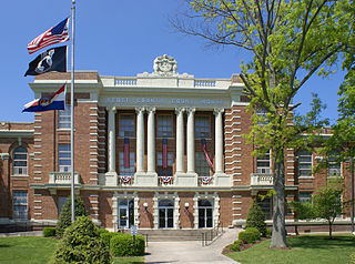
Wright County is a county located in the southern portion of the U.S. state of Missouri. As of the 2020 census, the population was 18,188. Its county seat is Hartville. The county was officially organized on January 29, 1841, and is named after Silas Wright, a former Congressman, U.S. Senator and Governor of New York.

<span class="mw-page-title-main">Webster County, Missouri</span> County in Missouri, United States

Webster County is a county located in the U.S. state of Missouri. As of the 2020 census, the population was 39,085. Its county seat is Marshfield. The county was organized in 1855 and named for U.S. Senator and U.S. Secretary of State Daniel Webster.

<span class="mw-page-title-main">Wayne County, Missouri</span> County in Missouri, United States

Wayne County is a county located in the Ozark foothills in the U.S. state of Missouri. As of the 2020 census, the population was 10,974. The county seat is Greenville. The county was officially organized on December 11, 1818, and is named after General "Mad" Anthony Wayne, who served in the American Revolution. As of August 28, 2023, Wayne County is designated the UFO Capital of Missouri, along with the city of Piedmont.

<span class="mw-page-title-main">Warren County, Missouri</span> County in Missouri, United States

Warren County is a county located in the eastern portion of the U.S. state of Missouri. As of the 2020 census, the population was 35,532. The county is located on the north side of the Missouri River. Its county seat is Warrenton. The county was established on January 5, 1833, and was named for General Joseph Warren, who died in the Battle of Bunker Hill during the American Revolutionary War.

<span class="mw-page-title-main">Taney County, Missouri</span> County in Missouri, United States

Taney County is a county in the southwestern portion of the U.S. state of Missouri. As of the 2020 census, the population was 56,066. Its county seat is Forsyth. It is included in the Branson, Missouri, Micropolitan Statistical Area.

<span class="mw-page-title-main">Stone County, Missouri</span> County in Missouri, United States

Stone County is located in the southwestern portion of the U.S. state of Missouri. As of the 2020 census, the population was 31,076. Its county seat is Galena.

<span class="mw-page-title-main">Stoddard County, Missouri</span> County in Missouri, United States

Stoddard County is a county located in the southeastern portion of the U.S. state of Missouri. As of the 2020 census, the population was 28,672. The county seat is Bloomfield. The county was officially organized on January 2, 1835, and is named for Amos Stoddard, the first American commandant of Upper Louisiana.

<span class="mw-page-title-main">Scott County, Missouri</span> County in Missouri, United States

Scott County is located in the southeastern portion of the U.S. state of Missouri. As of the 2020 census, the population was 38,059. Its county seat is Benton. The county was organized in 1821 and named for U.S. Representative John Scott, the first federal representative from Missouri. Scott County comprises the Sikeston, MO Micropolitan Statistical Area, which is also included in the Cape Girardeau-Sikeston, MO-IL Combined Statistical Area. The county is home to Scott County Central High School, which has won 18 state championships in boys basketball—the most of any high school in the state.

<span class="mw-page-title-main">Ozark County, Missouri</span> County in Missouri, United States

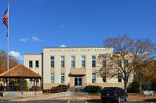
Ozark County is a county in the southern portion of the U.S. state of Missouri. As of the 2020 census, the population was 8,553. The largest city and county seat is Gainesville. The county was organized as Ozark County, named after the Ozark Mountains, on January 29, 1841. It was renamed Decatur County, after Commodore Stephen Decatur, from 1843 to 1845, after which the name Ozark County was restored.

<span class="mw-page-title-main">Newton County, Missouri</span> County in Missouri, United States

Newton County is a county located in the southwest portion of the U.S. state of Missouri. As of the 2020 census, the population was 58,648. Its county seat is Neosho. The county was organized in 1838 and is named in honor of John Newton, a hero who fought in the Revolutionary War.

<span class="mw-page-title-main">Livingston County, Missouri</span> County in Missouri, United States

Livingston County is a county located in the northwestern portion of the U.S. state of Missouri. As of the 2020 census, the population was 14,557. Its county seat is Chillicothe. The county was organized January 6, 1837, and named for U.S. Secretary of State Edward Livingston.

<span class="mw-page-title-main">Howell County, Missouri</span> County in Missouri, United States

Howell County is in southern Missouri. As of the 2020 census, the population was 39,750. The largest city and county seat is West Plains. The county was officially organized on March 2, 1851, and is named after Josiah Howell, a pioneer settler in the Howell Valley.

<span class="mw-page-title-main">Greene County, Missouri</span> County in Missouri, United States

Greene County is located in the southwest part of the U.S. state of Missouri. As of the 2020 census, its population was 298,915. making it the fourth most-populous county in Missouri.

<span class="mw-page-title-main">Dunklin County, Missouri</span> County in Missouri, United States

Dunklin County is located in the Bootheel of the U.S. state of Missouri. As of the 2020 census, the population was 28,283. The largest city and county seat is Kennett. The county was officially organized on February 14, 1845, and is named in honor of Daniel Dunklin, a Governor of Missouri who died the year before the county was organized.

<span class="mw-page-title-main">Christian County, Missouri</span> County in Missouri, United States

Christian County is located in the southwestern part of the U.S. state of Missouri. As of the 2020 census, its population was 88,842. Its county seat is Ozark. The county was organized in 1859 and is named after Christian County, Kentucky, which in turn is named for William Christian, a Kentucky soldier of the American Revolutionary War.

<span class="mw-page-title-main">Cape Girardeau County, Missouri</span> County in Missouri, United States

Cape Girardeau County is located in the southeastern part of the U.S. state of Missouri; its eastern border is formed by the Mississippi River. At the 2020 census, the population was 81,710. The county seat is Jackson, the first city in the US to be named in honor of President Andrew Jackson. Officially organized on October 1, 1812, the county is named after Ensign Sieur Jean Baptiste de Girardot, an official of the French colonial years. The "cape" in the county's name is named after a former promontory rock overlooking the Mississippi River; this feature was demolished during railroad construction. Cape Girardeau County is the hub of the Cape Girardeau–Jackson metropolitan area. Its largest city is Cape Girardeau.

<span class="mw-page-title-main">Camden County, Missouri</span> County in Missouri, United States

Camden County is a county located in the U.S. state of Missouri. As of the 2020 Census, the population was 42,745. Its county seat is Camdenton. The county was organized on January 29, 1841, as Kinderhook County and renamed Camden County in 1843 after Charles Pratt, 1st Earl Camden, Lord Chancellor of the United Kingdom and leader of the British Whig Party. Camden County is also the primary setting of the Netflix show Ozark.

<span class="mw-page-title-main">Buchanan County, Missouri</span> County in Missouri, United States

Buchanan County is located in the U.S. state of Missouri. As of the 2020 United States Census, the population was 84,793. Its county seat is St. Joseph. When originally formed in 1838, the county was named Roberts County, after settler Hiram Roberts. It was renamed in 1839 for James Buchanan, then a U.S. Senator and later President of the United States. The county was formed from land annexed to Missouri, as were five other counties.

<span class="mw-page-title-main">Boone County, Missouri</span> County in Missouri, United States

Boone County is located in the U.S. state of Missouri. Centrally located in Mid-Missouri, its county seat is Columbia, Missouri's fourth-largest city and location of the University of Missouri. As of the 2020 census, the population was 183,610, making it the state's eighth-most populous county. The county was organized November 16, 1820, and named for the then recently deceased Daniel Boone, whose kin largely populated the Boonslick area, having arrived in the 1810s on the Boone's Lick Road. Boone County comprises the Columbia Metropolitan Area. The towns of Ashland and Centralia are the second and third most populous towns in the county.

<span class="mw-page-title-main">Barry County, Missouri</span> County in Missouri, United States

Barry County is a county located in the southwest portion of the U.S. state of Missouri. As of the 2020 Census, the population was 34,534. Its county seat is Cassville. The county was organized in 1835 and named after William Taylor Barry, a U.S. Postmaster General from Kentucky. The town of Barry, also named after the postmaster-general, was located just north of Kansas City, not in Barry County.

References

  1. "McDonald County, Missouri". United States Census Bureau . Retrieved June 13, 2023.
  2. "Find a County". National Association of Counties. Archived from the original on May 31, 2011. Retrieved June 7, 2011.
  3. Gannett, Henry (1905). The Origin of Certain Place Names in the United States. U.S. Government Printing Office. p.  193.
  4. "2010 Census Gazetteer Files". United States Census Bureau. August 22, 2012. Archived from the original on October 21, 2013. Retrieved November 16, 2014.
  5. "U.S. Decennial Census". United States Census Bureau. Retrieved November 16, 2014.
  6. "Historical Census Browser". University of Virginia Library. Retrieved November 16, 2014.
  7. "Population of Counties by Decennial Census: 1900 to 1990". United States Census Bureau. Retrieved November 16, 2014.
  8. "Census 2000 PHC-T-4. Ranking Tables for Counties: 1990 and 2000" (PDF). United States Census Bureau. Archived (PDF) from the original on March 27, 2010. Retrieved November 16, 2014.
  9. "State & County QuickFacts". United States Census Bureau. Archived from the original on June 7, 2011. Retrieved September 10, 2013.
  10. "U.S. Census website". United States Census Bureau . Retrieved January 31, 2008.
  11. "P2 HISPANIC OR LATINO, AND NOT HISPANIC OR LATINO BY RACE – 2020: DEC Redistricting Data (PL 94-171) – McDonald County, Missouri".
  12. Breeding, Marshall. "McDonald County Library". Libraries.org. Retrieved May 8, 2017.
  13. Leip, David. "Dave Leip's Atlas of U.S. Presidential Elections". Uselectionatlas.org. Retrieved December 30, 2017.

Further reading

36°37′N94°21′W / 36.62°N 94.35°W / 36.62; -94.35