Lewis County, Missouri

Last updated

Lewis County
Lewis County MO Courthouse 20141022 A.jpg
Lewis County Courthouse in Monticello
Map of Missouri highlighting Lewis County.svg
Location within the U.S. state of Missouri
Missouri in United States.svg
Missouri's location within the U.S.
Coordinates: 40°05′N91°44′W / 40.09°N 91.73°W / 40.09; -91.73
CountryFlag of the United States.svg United States
StateFlag of Missouri.svg  Missouri
FoundedJanuary 2, 1833
Named for Meriwether Lewis
Seat Monticello
Largest city Canton
Area
  Total511 sq mi (1,320 km2)
  Land505 sq mi (1,310 km2)
  Water5.8 sq mi (15 km2)  1.1%
Population
 (2020)
  Total10,032
  Density20/sq mi (7.6/km2)
Time zone UTC−6 (Central)
  Summer (DST) UTC−5 (CDT)
Congressional district 6th
Website lewiscountymo.org
The Lewis County, Missouri courthouse in Monticello as it appeared in the mid-1870s. Lewis County Mo Courthouse.JPG
The Lewis County, Missouri courthouse in Monticello as it appeared in the mid-1870s.

Lewis County is a county located in the northeastern portion of the U.S. state of Missouri. As of the 2020 census, the population was 10,032. [1] Its county seat is Monticello. [2] The county was organized January 2, 1833, and named for Meriwether Lewis, the explorer and Governor of the Louisiana Territory. [3]

Contents

Lewis County is part of the Quincy, IL MO Micropolitan Statistical Area.

Geography

According to the U.S. Census Bureau, the county has a total area of 511 square miles (1,320 km2), of which 505 square miles (1,310 km2) is land and 5.8 square miles (15 km2) (1.1%) is water. [4]

Adjacent counties

Major highways

Transit

Railroads

History

Lewis County, located in the northeastern part of Missouri, across the Mississippi River from Illinois. It was established in 1833 and named after Meriwether Lewis of the Lewis and Clark Expedition. The county was largely settled by farmers from Virginia and Kentucky. They brought slaves and were attracted to the fertile land and easy river transportation. The economy was based on subsistence agriculture, timber harvesting, and lead mining. In addition. Canton supplied riverboats on the Mississippi. During the Civil War, the county became the base for rival pro-Confederate and pro-Union sympathizers; there was some violence but the Unionists prevailed. [5]

After the Civil War, the slaves were emancipated and the county's economy shifted towards commercial agriculture, with the production of corn, wheat and timber that were shipped through Canton, a port on the Mississippi River. In the late 19th and early 20th century, farm youth moved into small towns, particularly in the western part of the county. Mark Twain lived in the county briefly and was inspired by the natural beauty of the river region for his writing. [6]

Today, Lewis County is all rural, with a few small towns under 2500 population, and Canton at 2800. The economy us built on soybeans, corn and timber, as well as higher education. Canton is the home of Culver–Stockton College. The National Register of Historic Places celebrates 12 historic locations in the county.

Demographics

Historical population
CensusPop.Note
1840 6,040
1850 6,5788.9%
1860 12,28686.8%
1870 15,11423.0%
1880 15,9255.4%
1890 15,9350.1%
1900 16,7245.0%
1910 15,514−7.2%
1920 13,465−13.2%
1930 12,093−10.2%
1940 11,490−5.0%
1950 10,733−6.6%
1960 10,9842.3%
1970 10,9930.1%
1980 10,901−0.8%
1990 10,233−6.1%
2000 10,4942.6%
2010 10,211−2.7%
2020 10,032−1.8%
U.S. Decennial Census [7]
1790-1960 [8] 1900-1990 [9]
1990-2000 [10] 2010-2015 [11]

As of the census [12] of 2010, there were 10,211 people, 3,956 households, and 2,709 families residing in the county. The population density was 21 people per square mile. The racial makeup of the county was 95.92% White, 2.53% Black or African American, 0.16% Native American, 0.20% Asian, 0.02% Pacific Islander, 0.44% from other races, and 0.73% from two or more races. Approximately 0.73% of the population were Hispanic or Latino of any race. 34.9% were of German, 18.3% American, 11.2% English and 10.8% Irish ancestry.

The average household size was 2.46 and the average family size was 3.00. In the county, the population was spread out, with 25.00% under the age of 18, 12.90% from 18 to 24, 24.60% from 25 to 44, 21.40% from 45 to 64, and 16.10% who were 65 years of age or older and 51% of female population. The median age was 36 years.

Median income for a household in the county was $30,651, and the median income for a family was $35,740. Males had a median income of $27,778 versus $19,679 for females. The per capita income for the county was $14,746. 16.10% of the population and 10.70% of families were below the poverty line.

2020 Census

Lewis County Racial Composition [13]
RaceNum.Perc.
White (NH)9,31592.9%
Black or African American (NH)1851.84%
Native American (NH)300.3%
Asian (NH)220.22%
Pacific Islander (NH)00%
Other/Mixed (NH)3153.14%
Hispanic or Latino 1651.64%

Education

Public schools

Private schools

Post-secondary

Public libraries

Communities

Cities and towns

Unincorporated communities

Politics

Local

Lewis County, Missouri
Elected countywide officials
Assessor Tammy Logsdon Republican
Circuit Clerk Jan E. Geisendorfer Democratic
County Clerk
  • Chris Flanagan
Democratic
Collector Denise Goodwin Democratic
Commissioner
(Presiding)
Wayne Murphy, Jr. Republican
Commissioner
(District 1)
Deanne Whiston Republican
Commissioner
(District 2)
Travis Fleer Republican
Coroner Larry Arnold Democratic
Prosecuting Attorney Jules V. (Jake) DeCoster Democratic
Public Administrator Luke Barton Republican
Recorder Amy Parrish Democratic
Sheriff David T. Parrish Democratic
Surveyor Carson W. Lay Republican
Treasurer Bonnie Roberson Republican

Chris Flanagan was appointed to the position of County Clerk by Governor Jay Nixon. The office had previously been held by Regina Dredge.

State

Past Gubernatorial Elections Results
Year Republican Democratic Third Parties
2020 79.64%3,63819.26% 8801.10% 50
2016 63.53%2,81533.65% 1,4912.82% 125
2012 48.24% 2,04649.54%2,1012.22% 94
2008 56.79%2,53341.05% 1,8312.16% 96
2004 67.03%3,08431.32% 1,4411.65% 76
2000 50.03%2,22448.46% 2,1541.51% 67
1996 22.77% 94875.23%3,1321.99% 83

All of Lewis County is included in Missouri's 4th District in the Missouri House of Representatives and is represented by Craig Redmon (R-Canton).

Missouri House of Representatives — District 4 — Lewis County (2016)
PartyCandidateVotes%±%
Republican Craig Redmon3.998100.00%
Missouri House of Representatives — District 4 — Lewis County (2014)
PartyCandidateVotes%±%
Republican Craig Redmon2,450100.00%
Missouri House of Representatives — District 4 — Lewis County (2012)
PartyCandidateVotes%±%
Republican Craig Redmon3,869100.00%

All of Lewis County is a part of Missouri's 18th District in the Missouri Senate and is currently represented by Brian Munzlinger (R-Williamstown).

Missouri Senate — District 18 — Lewis County (2014)
PartyCandidateVotes%±%
Republican Brian Munzlinger2,363100.00%

Federal

U.S. Senate — Missouri — Lewis County (2016)
PartyCandidateVotes%±%
Republican Roy Blunt2,73261.84%+14.89
Democratic Jason Kander1,47233.32%-16.25
Libertarian Jonathan Dine982.22%-1.26
Green Johnathan McFarland601.36%+1.36
Constitution Fred Ryman561.27%+1.27
U.S. Senate — Missouri — Lewis County (2012)
PartyCandidateVotes%±%
Republican Todd Akin1,98246.95%
Democratic Claire McCaskill2,09349.57%
Libertarian Jonathan Dine1473.48%

All of Lewis County is included in Missouri's 6th Congressional District and is currently represented by Sam Graves (R-Tarkio) in the U.S. House of Representatives.

U.S. House of Representatives — Missouri's 6th Congressional District — Lewis County (2016)
PartyCandidateVotes%±%
Republican Sam Graves3,27075.82%+4.72
Democratic David M. Blackwell89920.84%-5.49
Libertarian Russ Lee Monchil882.04%-0.53
Green Mike Diel561.30%+1.30
U.S. House of Representatives — Missouri’s 6th Congressional District — Lewis County (2014)
PartyCandidateVotes%±%
Republican Sam Graves1,82271.10%+7.09
Democratic Bill Hedge69726.33%-7.28
Libertarian Russ Lee Monchil682.57%+0.20
U.S. House of Representatives — Missouri's 6th Congressional District — Lewis County (2012)
PartyCandidateVotes%±%
Republican Sam Graves2,58864.01%
Democratic Kyle Yarber1,35933.61%
Libertarian Russ Lee Monchil962.37%
United States presidential election results for Lewis County, Missouri [17]
Year Republican Democratic Third party
No.%No.%No.%
2020 3,55376.92%98421.30%821.78%
2016 3,34474.64%93420.85%2024.51%
2012 2,67762.56%1,50835.24%942.20%
2008 2,59457.62%1,83740.80%711.58%
2004 2,86261.63%1,75437.77%280.60%
2000 2,38853.26%2,02345.12%731.63%
1996 1,45334.79%2,05049.09%67316.12%
1992 1,46132.03%2,19648.14%90519.84%
1988 1,80342.20%2,46057.57%100.23%
1984 2,43855.22%1,97744.78%00.00%
1980 2,35049.07%2,31448.32%1252.61%
1976 1,98344.10%2,48655.28%280.62%
1972 2,73861.76%1,69538.24%00.00%
1968 2,03843.90%2,06744.53%53711.57%
1964 1,23927.41%3,28172.59%00.00%
1960 2,56048.43%2,72651.57%00.00%
1956 2,30145.75%2,72854.25%00.00%
1952 2,41645.41%2,89654.44%80.15%
1948 1,56433.06%3,15566.69%120.25%
1944 1,98840.72%2,88359.05%110.23%
1940 2,42840.86%3,48458.63%300.50%
1936 1,99433.78%3,85965.37%500.85%
1932 1,34126.07%3,74672.84%561.09%
1928 2,74148.55%2,88251.04%230.41%
1924 2,41639.48%3,48156.88%2233.64%
1920 2,81043.87%3,54255.30%530.83%
1916 1,42937.28%2,35761.49%471.23%
1912 1,00426.72%2,34062.27%41411.02%
1908 1,47336.89%2,43961.08%812.03%
1904 1,46739.08%2,20258.66%852.26%
1900 1,44235.07%2,58362.82%872.12%
1896 1,58137.28%2,62461.87%360.85%
1892 1,32235.49%2,22059.60%1834.91%
1888 1,41238.13%2,26861.25%230.62%

Missouri presidential preference primary (2008)

Former U.S. Senator Hillary Clinton (D-New York) received more votes, a total of 619, than any candidate from either party in Lewis County during the 2008 presidential primary.

See also

Related Research Articles

<span class="mw-page-title-main">Worth County, Missouri</span> County in Missouri, United States

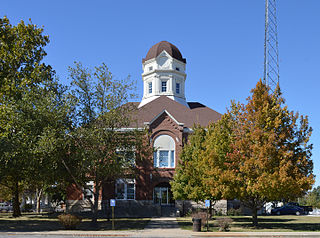
Worth County is a county located in the northwestern portion of the U.S. state of Missouri. As of the 2020 census, the population was 1,973. It is the smallest county in the state in population and, excluding the independent city of St. Louis, the smallest in total area. Its county seat is Grant City. The county was organized February 8, 1861, and named for General William J. Worth, who served in the Mexican–American War. Worth County is also the youngest county in the state.

<span class="mw-page-title-main">Shelby County, Missouri</span> County in Missouri, United States

Shelby County is a county located in the northeastern portion of the U.S. state of Missouri. As of the 2020 census, the population was 6,103. Its county seat is Shelbyville. The county was established on January 2, 1835, and named for Governor Isaac Shelby of Kentucky.

<span class="mw-page-title-main">Shannon County, Missouri</span> County in Missouri, United States

Shannon County is a county in the southern portion of the U.S. state of Missouri. As of the 2020 census, the population was 7,031. Its county seat is Eminence. The county was officially organized on January 29, 1841, and was named in honor of George F. "Peg-Leg" Shannon, a member of the Lewis and Clark Expedition. It is the second-largest county by area in Missouri.

<span class="mw-page-title-main">Schuyler County, Missouri</span> County in Missouri, United States

Schuyler County is a county located in the northeastern portion of the U.S. state of Missouri. As of the 2020 census, its population was 4,032, making it the fourth-least populous county in Missouri. Its county seat is Lancaster. The county was organized February 14, 1845, from Adair County, and named for General Philip Schuyler, delegate to the Continental Congress and U.S. Senator from New York.

<span class="mw-page-title-main">Pike County, Missouri</span> County in Missouri, United States

Pike County is a county on the eastern border of the U.S. state of Missouri, bounded by the Mississippi River. As of the 2020 census, the population was 17,587. Its county seat is Bowling Green. Its namesake was a city in middle Kentucky, a region from where many early migrants came. The county was organized December 14, 1818, and named for explorer Zebulon Pike. The folksong "Sweet Betsy from Pike" is generally thought to be associated with Pike County, Missouri.

<span class="mw-page-title-main">Pettis County, Missouri</span> County in Missouri, United States

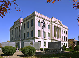
Pettis County is a county located in west central U.S. state of Missouri. As of the 2020 census, the population was 42,980. Its county seat is Sedalia. The county was organized on January 24, 1833, and named after former U.S. Representative Spencer Darwin Pettis.

<span class="mw-page-title-main">Osage County, Missouri</span> County in Missouri, United States

Osage County is a county in the central part of the U.S. state of Missouri. As of the 2020 census, the population was 13,274. Its county seat is Linn. The county was organized January 29, 1841, and named from the Osage River.

<span class="mw-page-title-main">Moniteau County, Missouri</span> County in Missouri, United States

Moniteau County is a county located in the U.S. state of Missouri. As of the 2020 United States census, the population was 15,473. Its county seat is California. The county was organized February 14, 1845, and named for the Moniteau Creek. 'Moniteau' is a French spelling of Manitou, Algonquian for the Great Spirit.

<span class="mw-page-title-main">Marion County, Missouri</span> County in Missouri, United States

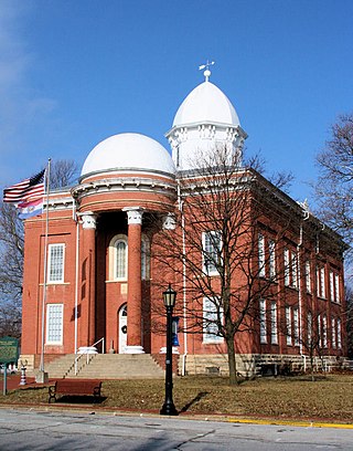
Marion County is a county located in the northeastern portion of Missouri. As of the 2020 census, the population was 28,525. Its county seat is Palmyra. Unique from most third-class counties in the state, Marion has two county courthouses, the second located in Hannibal. The county was organized on December 23, 1826 and named for General Francis Marion, the "Swamp Fox," who was from South Carolina and served in the American Revolutionary War. The area was known as the "Two Rivers Country" before organization.

<span class="mw-page-title-main">Macon County, Missouri</span> County in Missouri, United States

Macon County is a county located in the northern portion of the U.S. state of Missouri. As of the 2020 census, the population was 15,209. Its county seat is Macon. The county was organized January 6, 1837, and named for Nathaniel Macon, a Revolutionary War hero and North Carolina politician.

<span class="mw-page-title-main">Linn County, Missouri</span> County in Missouri, United States

Linn County is a county located in the northern portion of the U.S. state of Missouri. As of the 2020 census, the population was 11,874. Its county seat is Linneus. The county was organized January 1, 1837, and named after U.S. Senator Lewis F. Linn of Missouri.

<span class="mw-page-title-main">Knox County, Missouri</span> County in Missouri, United States

Knox County is a county located in the northeast portion of the U.S. state of Missouri. As of the 2020 census, its population was 3,744, making it the third-least populous county in Missouri. Its county seat is Edina. The county was organized February 14, 1845, and named for U.S. Secretary of War General Henry Knox.

<span class="mw-page-title-main">Howard County, Missouri</span> County in Missouri, United States

Howard County is located in the U.S. state of Missouri, with its southern border formed by the Missouri River. As of the 2020 census, the population was 10,151. Its county seat is Fayette. The county was organized January 23, 1816, and named for Benjamin Howard, the first Governor of the Missouri Territory. Settled originally by migrants from the Upper South, it is part of the region historically known as Little Dixie. It is part of the Columbia, Missouri, metropolitan area.

<span class="mw-page-title-main">Holt County, Missouri</span> County in Missouri, United States

Holt County is a county located in the northwestern portion of the U.S. state of Missouri. As of the 2020 census, the population was 4,223. It's county seat is Oregon. The county was organized February 15, 1841. Originally named Nodaway County, it was soon renamed for David Rice Holt (1803–1840), a Missouri state legislator from Platte County.

<span class="mw-page-title-main">Hickory County, Missouri</span> County in Missouri, United States

Hickory County is located in the U.S. state of Missouri. As of the 2020 census, the population was 8,279. Its county seat is Hermitage. The county was organized February 14, 1845, and named after President Andrew Jackson, whose nickname was "Old Hickory." The Pomme de Terre Dam, a Corps of Engineers facility, is located three miles south of Hermitage and forms Lake Pomme de Terre by damming the Pomme de Terre River and Lindley Creek. Truman Reservoir, also a Corps of Engineers facility, floods the Pomme de Terre Reservoir from the northern border of the county southward to the city limits of Hermitage.

<span class="mw-page-title-main">Henry County, Missouri</span> County in Missouri, United States

Henry County is a county located in the western portion of the U.S. state of Missouri. As of the 2020 census, the population was 21,946. Its county seat is Clinton. The county was organized December 13, 1834, as Rives County but was renamed in 1841 for Revolutionary War patriot Patrick Henry. The county originally had been named after William Cabell Rives, who was then serving as a U.S. Senator from Virginia. However, Rives lost popularity in Missouri after he joined the Whig Party.

<span class="mw-page-title-main">Dade County, Missouri</span> County in Missouri, United States

Dade County is a county located in the southwest part of the U.S. state of Missouri. As of the 2020 census, the population was 7,569. Its county seat is Greenfield. The county was organized in 1841 and named after Major Francis L. Dade of Virginia, who was killed in the Second Seminole War in 1835.

<span class="mw-page-title-main">Clark County, Missouri</span> County in Missouri, United States

Clark County is a county located in the U.S. state of Missouri. As of the 2020 census, its population was 6,634. Its county seat is Kahoka. The county was organized December 16, 1836, and named for William Clark, leader of the Lewis and Clark Expedition and later Governor of Missouri Territory.

<span class="mw-page-title-main">Chariton County, Missouri</span> County in Missouri, United States

Chariton County is a county located in the north-central portion of the U.S. state of Missouri. As of the 2020 census, the population was 7,408. Its county seat is Keytesville. The county was organized November 16, 1820, from part of Howard County and is named for the Chariton River.

<span class="mw-page-title-main">Three Forks, Montana</span> City in Montana, United States

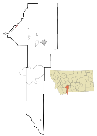
Three Forks is a city in Gallatin County, Montana, United States and is located within the watershed valley system of both the Missouri and Mississippi rivers drainage basins — and is historically considered the birthplace or start of the Missouri River. The population was 1,989 at the 2020 census. The city of Three Forks is named so because it lies geographically near the point, in nearby Missouri Headwaters State Park, where the Jefferson, Madison, and Gallatin rivers converge to form the Missouri River — the longest single river in North America, as well as the major portion of the Missouri–Mississippi River System from the headwaters near Three Forks to its discharge into the Gulf of Mexico. Three Forks is part of the Bozeman, MT Micropolitan Statistical Area of approximately 100,000 people and located thirty miles west of Bozeman.

References

  1. "Explore Census Data". data.census.gov. Retrieved January 4, 2022.
  2. "Find a County". National Association of Counties. Retrieved June 7, 2011.
  3. Eaton, David Wolfe (1916). How Missouri Counties, Towns and Streams Were Named. The State Historical Society of Missouri. pp.  185.
  4. "2010 Census Gazetteer Files". United States Census Bureau. August 22, 2012. Archived from the original on September 13, 2014. Retrieved November 16, 2014.
  5. George R. Lee, “Slavery and Emancipation in Lewis County, Missouri,” Missouri Historical Review 65#3 (April 1971), p. 294-313.
  6. Lewis County Historical and Genealogical Society, Lewis County, Missouri: a Bicentennial History (2016).
  7. "U.S. Decennial Census". United States Census Bureau. Retrieved November 16, 2014.
  8. "Historical Census Browser". University of Virginia Library. Retrieved November 16, 2014.
  9. "Population of Counties by Decennial Census: 1900 to 1990". United States Census Bureau. Retrieved November 16, 2014.
  10. "Census 2000 PHC-T-4. Ranking Tables for Counties: 1990 and 2000" (PDF). United States Census Bureau. Archived (PDF) from the original on March 27, 2010. Retrieved November 16, 2014.
  11. "State & County QuickFacts". United States Census Bureau. Archived from the original on June 7, 2011. Retrieved September 10, 2013.
  12. "U.S. Census website". United States Census Bureau . Retrieved January 31, 2008.
  13. "P2 HISPANIC OR LATINO, AND NOT HISPANIC OR LATINO BY RACE – 2020: DEC Redistricting Data (PL 94-171) – Lewis County, Missouri".
  14. Breeding, Marshall. "Canton Public Library". Libraries.org. Retrieved May 8, 2017.
  15. Breeding, Marshall. "Labelle Branch Library". Libraries.org. Retrieved May 8, 2017.
  16. Breeding, Marshall. "Lagrange Branch Library". Libraries.org. Retrieved May 8, 2017.
  17. Leip, David. "Dave Leip's Atlas of U.S. Presidential Elections". uselectionatlas.org. Retrieved March 25, 2018.

40°05′N91°44′W / 40.09°N 91.73°W / 40.09; -91.73