Madison County, Missouri

Last updated

Madison County
Madison County Missouri Courthouse at Fredericktown, MO USA.jpg
Madison County Courthouse in Fredericktown
Map of Missouri highlighting Madison County.svg
Location within the U.S. state of Missouri
Missouri in United States.svg
Missouri's location within the U.S.
Coordinates: 37°29′N90°20′W / 37.48°N 90.34°W / 37.48; -90.34
CountryFlag of the United States.svg United States
StateFlag of Missouri.svg  Missouri
FoundedDecember 14, 1818
Named for James Madison
Seat Fredericktown
Largest cityFredericktown
Area
  Total498 sq mi (1,290 km2)
  Land494 sq mi (1,280 km2)
  Water3.2 sq mi (8 km2)  0.6%
Population
 (2020)
  Total12,626
  Density25/sq mi (9.8/km2)
Time zone UTC−6 (Central)
  Summer (DST) UTC−5 (CDT)
Congressional district 8th
Website madisoncountymo.us

Madison County is a county located in the Lead Belt region of the U.S. state of Missouri. As of the 2020 census, the population was 12,626. [1] Its county seat and largest city is Fredericktown. [2] The county was officially organized on December 14, 1818, and was named after President James Madison. [3]

Contents

Mining has been a key industry in this area with Madison County recorded as having the oldest lead mine west of the Mississippi River.

Geography

According to the U.S. Census Bureau, the county has a total area of 498 square miles (1,290 km2), of which 494 square miles (1,280 km2) is land and 3.2 square miles (8.3 km2) (0.6%) is water. [4]

Adjacent counties

Major highways

National protected area

Demographics

Historical population
CensusPop.Note
1820 2,047
1830 2,37115.8%
1840 3,39543.2%
1850 6,00376.8%
1860 5,664−5.6%
1870 5,8493.3%
1880 8,87651.8%
1890 9,2684.4%
1900 9,9757.6%
1910 11,27313.0%
1920 10,721−4.9%
1930 9,418−12.2%
1940 9,6562.5%
1950 10,3807.5%
1960 9,366−9.8%
1970 8,641−7.7%
1980 10,72524.1%
1990 11,1273.7%
2000 11,8006.0%
2010 12,2263.6%
2020 12,6263.3%
U.S. Decennial Census [5]
1790-1960 [6] 1900-1990 [7]
1990-2000 [8] 2010-2015 [9]

As of the census [10] of 2000, there were 11,800 people, 4,711 households, and 3,330 families residing in the county. The population density was 24 people per square mile (9.3 people/km2). There were 5,656 housing units at an average density of 11 units per square mile (4.2/km2). The racial makeup of the county was 98.30% White, 0.13% Black or African American, 0.25% Native American, 0.29% Asian, 0.20% from other races, and 0.83% from two or more races. Approximately 0.56% of the population were Hispanic or Latino of any race.

There were 4,711 households, out of which 31.20% had children under the age of 18 living with them, 57.40% were married couples living together, 10.10% had a female householder with no husband present, and 29.30% were non-families. 25.90% of all households were made up of individuals, and 14.30% had someone living alone who was 65 years of age or older. The average household size was 2.46 and the average family size was 2.93.

In the county, the population was spread out, with 24.60% under the age of 18, 7.90% from 18 to 24, 26.30% from 25 to 44, 23.30% from 45 to 64, and 18.00% who were 65 years of age or older. The median age was 39 years. For every 100 females there were 92.10 males. For every 100 females age 18 and over, there were 87.70 males.

The median income for a household in the county was $30,421, and the median income for a family was $37,474. Males had a median income of $27,670 versus $15,909 for females. The per capita income for the county was $15,825. About 12.80% of families and 17.20% of the population were below the poverty line, including 22.60% of those under age 18 and 16.20% of those age 65 or over.

Religion

According to the Association of Religion Data Archives County Membership Report (2000), Madison County is a part of the Bible Belt with evangelical Protestantism being the majority religion. The most predominant denominations among residents in Madison County who adhere to a religion are Southern Baptists (37.87%), Independent/Non-Charismatic Churches (17.42%), and National Association of Free Will Baptists (12.10%).

2020 Census

Madison County Racial Composition [11]
RaceNum.Perc.
White (NH)11,55591.52%
Black or African American (NH)540.43%
Native American (NH)490.4%
Asian (NH)410.32%
Pacific Islander (NH)00%
Other/Mixed (NH)5854.63%
Hispanic or Latino 3422.71%

Education

Of adults 25 years of age and older in Madison County, 68.6% possesses a high school diploma while 7.8% holds a bachelor's degree as their highest educational attainment.

Public schools

Private schools

Public libraries

Politics

Local

Both the Republican and Democratic parties split control of the local elected offices in Madison County.

Madison County, Missouri
Elected countywide officials
Assessor Sue Smallen Yount Republican
Circuit Clerk Tenia Hermann Republican
County Clerk Donal E. Firebaugh Democratic
Collector Debby Boone Republican
Commissioner
(Presiding)
Jason Green Republican
Commissioner
(District 1)
Tom Stephens Republican
Commissioner
(District 2)
Larry Kemp Republican
Coroner Collin Follis Democratic
Prosecuting Attorney M. Dwight Robbins Republican
Public Administrator Carol Lachance Republican
Recorder Saundra Ivison Republican
Sheriff Katy McCutcheon Democratic
Surveyor William Douglas McFarland Democratic
Treasurer Jessica Stevens Republican

State

All of Madison County is a part of Missouri's 145th District in the Missouri House of Representatives and is currently represented by Rick Francis (R-Perryville). The 156th District includes all of Bollinger and Madison counties as well as most of Perry County, Missouri.

Missouri House - District 145 - Madison County (2020) [13]
PartyCandidateVotes%±%
Republican Rick Francis 4,48981.4
Democratic Mike Lindley1,02618.6

All of Madison County is a part of Missouri's 27th District in the Missouri Senate and is currently represented by State Senator Holly Rehder (R-Scott City). The 27th Senatorial District includes all of Bollinger, Cape Girardeau, Madison, Mississippi, Perry and Scott counties.

Missouri Senate - District 27 - Madison County (2008)
PartyCandidateVotes%±%
Republican Jason Crowell2,77857.31
Democratic Linda Sanders2,06942.69
Missouri Senate - District 27 - Madison County (2020) [14]
PartyCandidateVotes%±%
Republican Holly Rehder 4,30777.8
Democratic Donnie Owens1,22926.4
Past Gubernatorial Elections Results
Year Republican Democratic Third Parties
2020 77.09%4,36219.9% 1,1263.01% 170
2016 64.16%3,40532.17% 1,7073.67% 195
2012 46.95% 2,29850.15%2,4552.90% 142
2008 43.13% 2,16054.29%2,7192.58% 129
2004 57.86%2,81940.48% 1,9721.66% 81
200050.50%2,21046.85% 2,0502.65% 116
199636.82% 1,70960.51%2,8092.67% 124
199245.62% 2,28954.38%2,7280.00% 0
198863.41%2,98936.42% 1,7170.17% 8
198458.94%2,74641.06% 1,9130.00% 0
198058.00%2,88941.92% 2,0880.08% 4
197650.34%1,99449.63% 1,9660.00% 0

Federal

Madison County is included in Missouri's 8th Congressional District and is currently represented by Jason T. Smith (R-Salem) in the U.S. House of Representatives. Smith won a special election on Tuesday, June 4, 2013, to finish out the remaining term of U.S. Representative Jo Ann Emerson (R-Cape Girardeau). Emerson announced her resignation a month after being reelected with over 70 percent of the vote in the district. She resigned to become CEO of the National Rural Electric Cooperative.

U.S. House of Representatives - District 8 – Madison County (2012)
PartyCandidateVotes%±%
Republican Jo Ann Emerson3,65574.65+8.63
Democratic Jack Rushin1,10622.59-6.72
Libertarian Rick Vandeven1352.76+1.31
U.S. House of Representatives - District 8 - Special Election – Madison County (2013)
PartyCandidateVotes%±%
Republican Jason T. Smith60859.84
Democratic Steve Hodges32331.79
Constitution Doug Enyart434.23
Write-In Thomas Brown292.85
Libertarian Bill Slantz121.18
Write-In Wayne L. Byington10.10
U.S. House of Representatives - District 8 – Madison County (2020) [15]
PartyCandidateVotes%±%
Republican Jason Smith (politician) 4,41378.9
Democratic Kathy Ellis1,08519.4
Libertarian Tom Schmitz951.7

Political culture

United States presidential election results for Madison County, Missouri [16]
Year Republican Democratic Third party
No.%No.%No.%
2020 4,58480.76%1,01917.95%731.29%
2016 4,10277.09%1,00518.89%2144.02%
2012 3,22765.46%1,58832.21%1152.33%
2008 2,89757.62%2,04240.61%891.77%
2004 2,90559.07%1,97240.10%410.83%
2000 2,46056.25%1,82841.80%851.94%
1996 1,59534.21%2,35150.42%71715.38%
1992 1,67332.92%2,50149.21%90817.87%
1988 2,52853.75%2,16746.08%80.17%
1984 2,80860.13%1,86239.87%00.00%
1980 2,61853.02%2,23145.18%891.80%
1976 1,73943.59%2,22955.88%210.53%
1972 2,83766.16%1,45133.84%00.00%
1968 2,16450.33%1,52135.37%61514.30%
1964 1,75639.25%2,71860.75%00.00%
1960 2,96061.23%1,87438.77%00.00%
1956 2,76354.79%2,28045.21%00.00%
1952 2,67652.98%2,37547.02%00.00%
1948 2,08645.36%2,50954.56%40.09%
1944 2,27750.74%2,20349.09%80.18%
1940 2,49550.87%2,40549.03%50.10%
1936 2,01346.36%2,32353.50%60.14%
1932 1,42837.70%2,34761.96%130.34%
1928 2,16562.02%1,32637.98%00.00%
1924 1,56948.06%1,66551.00%310.95%
1920 2,02352.19%1,83047.21%230.59%
1916 1,23047.84%1,31050.95%311.21%
1912 82737.59%1,12651.18%24711.23%
1908 1,24847.29%1,32150.06%702.65%
1904 1,10649.33%1,07647.99%602.68%
1900 88142.75%1,15355.94%271.31%
1896 78038.09%1,25661.33%120.59%
1892 63536.45%1,01057.98%975.57%
1888 68536.59%1,11859.72%693.69%

Missouri presidential preference primary (2008)

In the 2008 Missouri Presidential Preference Primary, voters in Madison County from both political parties supported candidates who finished in second place in the state at large and nationally.

Former U.S. Senator Hillary Clinton (D-New York) received more votes (a total of 971) in Madison County during the 2008 primaries than any candidate from either party.

Communities

Cities

Town

Villages

Census-designated places

Other unincorporated communities

See also

Related Research Articles

<span class="mw-page-title-main">Worth County, Missouri</span> County in Missouri, United States

Worth County is a county located in the northwestern portion of the U.S. state of Missouri. As of the 2020 census, the population was 1,973. It is the smallest county in the state in population and, excluding the independent city of St. Louis, the smallest in total area. Its county seat is Grant City. The county was organized February 8, 1861, and named for General William J. Worth, who served in the Mexican–American War. Worth County is also the youngest county in the state.

<span class="mw-page-title-main">Wayne County, Missouri</span> County in Missouri, United States

Wayne County is a county located in the Ozark foothills in the U.S. state of Missouri. As of the 2020 census, the population was 10,974. The county seat is Greenville. The county was officially organized on December 11, 1818, and is named after General "Mad" Anthony Wayne, who served in the American Revolution. As of August 28, 2023, Wayne County is designated the UFO Capital of Missouri, along with the city of Piedmont.

<span class="mw-page-title-main">Ozark County, Missouri</span> County in Missouri, United States

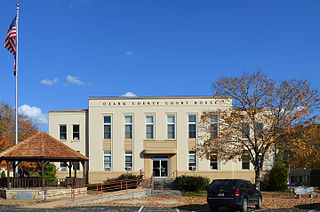
Ozark County is a county in the southern portion of the U.S. state of Missouri. As of the 2020 census, the population was 8,553. The largest city and county seat is Gainesville. The county was organized as Ozark County, named after the Ozark Mountains, on January 29, 1841. It was renamed Decatur County, after Commodore Stephen Decatur, from 1843 to 1845, after which the name Ozark County was restored.

<span class="mw-page-title-main">Knox County, Missouri</span> County in Missouri, United States

Knox County is a county located in the northeast portion of the U.S. state of Missouri. As of the 2020 census, its population was 3,744, making it the third-least populous county in Missouri. Its county seat is Edina. The county was organized February 14, 1845, and named for U.S. Secretary of War General Henry Knox.

<span class="mw-page-title-main">Henry County, Missouri</span> County in Missouri, United States

Henry County is a county located in the western portion of the U.S. state of Missouri. As of the 2020 census, the population was 21,946. Its county seat is Clinton. The county was organized December 13, 1834, as Rives County but was renamed in 1841 for Revolutionary War patriot Patrick Henry. The county originally had been named after William Cabell Rives, who was then serving as a U.S. Senator from Virginia. However, Rives lost popularity in Missouri after he joined the Whig Party.

<span class="mw-page-title-main">Crawford County, Missouri</span> County in Missouri, United States

Crawford County is a county located in the east-central portion of the U.S. state of Missouri. At the 2020 Census, the population was 23,056. Its county seat is Steelville. The county was organized in 1829 and is named after U.S. Senator William H. Crawford of Georgia.

<span class="mw-page-title-main">Cooper County, Missouri</span> County in Missouri, United States

Cooper County is located in the central portion of the U.S. state of Missouri. As of the 2020 United States census, the population was 17,103. Its county seat is Boonville. The county was organized December 17, 1818, and named for Sarshell Cooper, a frontier settler who was killed by Native Americans near Arrow Rock in 1814. It is a part of the Columbia, Missouri metropolitan area.

<span class="mw-page-title-main">Clark County, Missouri</span> County in Missouri, United States

Clark County is a county located in the U.S. state of Missouri. As of the 2020 census, its population was 6,634. Its county seat is Kahoka. The county was organized December 16, 1836, and named for William Clark, leader of the Lewis and Clark Expedition and later Governor of Missouri Territory.

<span class="mw-page-title-main">Bollinger County, Missouri</span> County in Missouri, United States

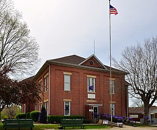
Bollinger County is a county located in the southeastern part of the U.S. state of Missouri. As of the 2020 census, the county's population was 10,567. The county seat, largest and only city, is Marble Hill. The largely rural county is supported by agriculture and construction. The county was officially organized in March 1851 from portions of Wayne, Cape Girardeau and Stoddard Counties, and named in honor of George Frederick Bollinger, an early settler.

<span class="mw-page-title-main">Polk County, Iowa</span> County in Iowa, United States

Polk County is located in the U.S. state of Iowa. As of the 2020 census, the population was 492,401. It is Iowa's most populous county, and home to over 15% of the state's residents. The county seat is Des Moines, which is also the capital city of Iowa. Polk County is included in the Des Moines–West Des Moines, IA Metropolitan Statistical Area.

<span class="mw-page-title-main">Fremont County, Iowa</span> County in Iowa, United States

Fremont County is a county located in the U.S. state of Iowa. As of the 2020 census the population was 6,605, making it the state's seventh-least populous county. The county seat is Sidney. The county was formed in 1847 and named for the military officer John C. Frémont.

<span class="mw-page-title-main">Glen Allen, Missouri</span> Village in Missouri, United States

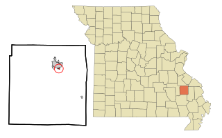
Glen Allen is a village in central Bollinger County in Southeast Missouri, United States, located near the intersection of State Highway 34 and Route ZZ just west of Marble Hill. The population was 57 at the 2020 census.

<span class="mw-page-title-main">Marble Hill, Missouri</span> City in Missouri, United States

Marble Hill is a fourth-class city in central Bollinger County in Southeast Missouri, United States. Located at the intersection of State Highways 34 and 51, it is the largest city in Bollinger and serves as the county seat. The population was 1,388 at the 2020 census. The city was officially organized in July 1851 and is named after a marble-like rock.

<span class="mw-page-title-main">Cobalt, Missouri</span> Village in Missouri, United States

Cobalt is a village in Madison County, Missouri, United States. As of the 2020 census, the population was 264, up from 226 in 2010.

<span class="mw-page-title-main">Fredericktown, Missouri</span> City in Missouri, United States

Fredericktown is a city in and the county seat of Madison County, Missouri, United States, in the northeastern foothills of the St. Francois Mountains. The population was 4,429 at the 2020 census, up from 3,985 in 2010. The city is surrounded on three sides by the easternmost parcel of the Mark Twain National Forest.

<span class="mw-page-title-main">Junction City, Missouri</span> Village in Missouri, United States

Junction City is a village in Madison County, Missouri, United States. The population was 283 at the 2020 census, down from 327 in 2010.

<span class="mw-page-title-main">Marquand, Missouri</span> City in Missouri, United States

Marquand is a small city in eastern Madison County, Missouri, United States. The population was 186 at the 2020 census. Marquand was officially recognized and incorporated as a town in 1906.

<span class="mw-page-title-main">Madison, Missouri</span> City in Missouri, United States

Madison is a city in Monroe County, Missouri, United States. The population was 515 at the 2020 census.

<span class="mw-page-title-main">Fredericktown, Ohio</span> Village in Ohio, United States

Fredericktown is a village in Knox County, Ohio, United States. The population was 2,648 at the 2020 census.

<span class="mw-page-title-main">Newman Grove, Nebraska</span> City in Platte County, Nebraska, United States

Newman Grove is a city in Madison and Platte counties in Nebraska, United States. The population was 721 at the 2010 census.

References

  1. "Explore Census Data". data.census.gov. Retrieved January 14, 2022.
  2. "Find a County". National Association of Counties. Retrieved June 7, 2011.
  3. Eaton, David Wolfe (1916). How Missouri Counties, Towns and Streams Were Named. The State Historical Society of Missouri. pp.  192.
  4. "2010 Census Gazetteer Files". United States Census Bureau. August 22, 2012. Archived from the original on October 21, 2013. Retrieved November 16, 2014.
  5. "U.S. Decennial Census". United States Census Bureau. Retrieved November 16, 2014.
  6. "Historical Census Browser". University of Virginia Library. Retrieved November 16, 2014.
  7. "Population of Counties by Decennial Census: 1900 to 1990". United States Census Bureau. Retrieved November 16, 2014.
  8. "Census 2000 PHC-T-4. Ranking Tables for Counties: 1990 and 2000" (PDF). United States Census Bureau. Archived (PDF) from the original on March 27, 2010. Retrieved November 16, 2014.
  9. "State & County QuickFacts". United States Census Bureau. Archived from the original on June 7, 2011. Retrieved September 10, 2013.
  10. "U.S. Census website". United States Census Bureau . Retrieved January 31, 2008.
  11. "P2 HISPANIC OR LATINO, AND NOT HISPANIC OR LATINO BY RACE – 2020: DEC Redistricting Data (PL 94-171) – Madison County, Missouri".
  12. Breeding, Marshall. "Fredericktown Branch Library". Libraries.org. Retrieved May 8, 2017.
  13. "Missouri State House - District 145 Election Results | des Moines Register". The Des Moines Register .
  14. "Missouri State Senate - District 27 Election Results | the Florida Times-Union".
  15. "Missouri U.S. House - District 8 Election Results | des Moines Register". The Des Moines Register .
  16. Leip, David. "Dave Leip's Atlas of U.S. Presidential Elections". uselectionatlas.org. Retrieved March 23, 2021.

37°29′N90°20′W / 37.48°N 90.34°W / 37.48; -90.34