Related Research Articles

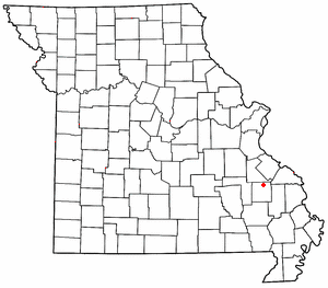
Sainte Genevieve County, often abbreviated Ste. Genevieve County, is a county located in the eastern portion of the U.S. state of Missouri. As of the 2020 census, the population was 18,479. The largest city and county seat is Ste. Genevieve. The county was officially organized on October 1, 1812, and is named after the Spanish district once located in the region, after Saint Genevieve, patroness of Paris, France.

Perry County is a county located in the southeastern portion of the U.S. state of Missouri. As of the 2020 census, the population was 18,956. Its county seat is Perryville. The county was officially organized on November 16, 1820 from Ste. Genevieve County and was named after Oliver Hazard Perry, a naval hero of the War of 1812.

Fredericktown is a city in and the county seat of Madison County, Missouri, United States, in the northeastern foothills of the St. Francois Mountains. The population was 4,429 at the 2020 census. The city is surrounded on three sides by the easternmost parcel of the Mark Twain National Forest.

Ste. Genevieve is a city in Ste. Genevieve Township and is the county seat of Ste. Genevieve County, Missouri, United States. The population was 4,999 at the 2020 census. Founded in 1735 by French Canadian colonists and settlers from east of the river, it was the first organized European settlement west of the Mississippi River in present-day Missouri. Today, it is home to Ste. Genevieve National Historical Park, the 422nd unit of the National Park Service.

The American Bottom is the flood plain of the Mississippi River in the Metro-East region of Southern Illinois, extending from Alton, Illinois, south to the Kaskaskia River. It is also sometimes called "American Bottoms". The area is about 175 square miles (450 km2), mostly protected from flooding in the 21st century by a levee and drainage canal system. Immediately across the river from St. Louis, Missouri, are industrial and urban areas, but nearby marshland, swamps, and the Horseshoe Lake are reminders of the Bottoms' riparian nature.
Mine La Motte is an unincorporated community and census-designated place in Madison County, Missouri, United States. It is located approximately six miles north of Fredericktown. Europeans discovered lead here and had also hoped to find silver. The French Governor of Louisiana, Antoine de la Mothe Cadillac, failed to find silver, but succeeded in recruiting investors in The Company of the West, which was organized in 1717. Mine La Motte was eventually settled by about 200 French settlers along with their slaves from Santo Domingo, under the leadership of Philip François Renault, to develop mines in 1717, making it one of the oldest settlements west of the Mississippi River. The presence of lead, a critical ingredient for ammunition, attracted unusually early mining by French colonists in this otherwise remote interior region of the North American continent. That same lead, still used for ammunition at the time of the American Civil War, was also a factor in the Battle of Fredericktown in which forces aligned with the Confederate States of America fought for control of the lead smelters in nearby Fredericktown with the Unionist forces, aligned with the United States of America.
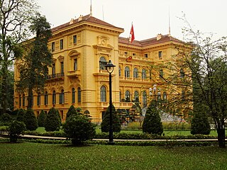
French colonial architecture includes several styles of architecture used by the French during colonization. Many former French colonies, especially those in Southeast Asia, have previously been reluctant to promote their colonial architecture as an asset for tourism; however, in recent times, the new generation of local authorities has somewhat "embraced" the architecture and has begun to advertise it. French Colonial architecture has a long history, beginning in North America in 1604 and being most active in the Western Hemisphere until the 19th century, when the French turned their attention more to Africa, Asia, and the Pacific.

Poteaux-sur-sol is a style of timber framing in which relatively closely spaced posts rest on a timber sill. Poteaux-en-terre and pieux-en-terre are similar, but the closely spaced posts extend into the ground rather than resting on a sill on a foundation, and therefore are a type of post in ground construction. Poteaux-sur-sol is similar to the framing style known in the United Kingdom as close studding. Poteaux-sur-sol has also, confusingly, been used for other types of timber framing which have a sill timber such as post-and-plank, but this is considered incorrect by some scholars.
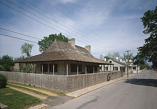
The Louis Bolduc House, also known as Maison Bolduc, is a historic house museum at 123 South Main Street in Ste. Geneviève, Missouri. It is an example of poteaux sur solle ("posts-on-sill") construction, and is located in the first European settlement in the present-day state of Missouri. The first historic structure in Ste. Genevieve to be authentically restored, the house is a prime example of the traditional French Colonial architecture of the early 18th century in North America and was designated in 1970 as a National Historic Landmark.

Ste. Genevieve Historic District is a historic district encompassing much of the built environment of Ste. Genevieve, Missouri, United States. The city was in the late 18th century the capital of Spanish Louisiana, and, at its original location a few miles south, capital of French Louisiana as well. A large area of the city, including fields along the Mississippi River, is a National Historic Landmark District designated in 1960, for its historically French architecture and land-use patterns, while a smaller area, encompassing the parts of the city historically important between about 1790 and 1950, was named separately to the National Register of Historic Places in 2002.
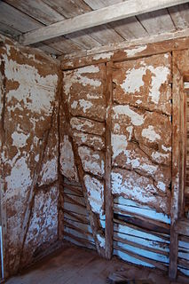
Bousillage is a mixture of clay and grass or other fibrous substances used as the infill (chinking) between the timbers of a half-timbered building. This material was commonly used by 18th-century French colonial settlers in the historical New France region of the United States and is similar to the material cob and adobe. In French torchis has the same meaning or the meaning of a loaf of this material.

A post in ground construction, also called earthfast or hole-set posts, is a type of construction in which vertical, roof-bearing timbers, called posts, are in direct contact with the ground. They may be placed into excavated postholes, driven into the ground, or on sills which are set on the ground without a foundation. Earthfast construction is common from the Neolithic period to the present and is used worldwide. Post-in-the-ground construction is sometimes called an "impermanent" form, used for houses which are expected to last a decade or two before a better quality structure can be built.

Missouri French or Illinois Country French also known as français vincennois, français Cahok, and nicknamed "Paw-Paw French" often by individuals outside the community but not exclusively, is a variety of the French language spoken in the upper Mississippi River Valley in the Midwestern United States, particularly in eastern Missouri.
Old Mines is the name of an unincorporated community and surrounding area in southeast Missouri that were settled by French colonists in the early 18th century when the area was part of the Illinois Country of New France. The early settlers came to mine for lead, and their descendants still inhabit the area where, through a combination of geographic and cultural isolation, they maintained a distinctive French culture well into the 20th century. As recently as the late 1980s there may have been a thousand native speakers of the region's Missouri French dialect. This culturally distinct population has sometimes been referred to as "paw-paw French" and lives in an amorphous area in Washington, Jefferson, and St. Francois counties roughly 15 miles (24 km) either side of a line from Potosi to De Soto. The community of Old Mines itself is in northeastern Washington County, six miles north of Potosi.
The Reverend Henry Platte was the first native Catholic priest of what is now the State of Missouri in the United States. He was curé of the Church of Ste. Genevieve in Ste. Genevieve, Missouri in 1815, and pastor from 1816 until his death from yellow fever in 1822.

Le Grand Village Sauvage, also called Chalacasa, was a Native American village located near Old Appleton in Perry County, Missouri, United States.
La Saline is an abandoned village located in Beauvais Township in Sainte Genevieve County, Missouri, United States. La Saline is located approximately six miles south of Sainte Genevieve.

Saline Creek is a creek that rises in western Ste. Genevieve County and flows east briefly passing through a portion of northern Perry County before emptying into an offshoot of the Mississippi River north of St. Mary across from Kaskaskia Island.

Saline Township is a subdivision of Ste. Genevieve County, Missouri, in the United States of America, and is one of the five townships located in Ste. Genevieve County.
Ste. Genevieve Township is a subdivision of Ste. Genevieve County, Missouri, in the United States of America, and is one of the five townships located in Ste. Genevieve County.
References
- 1 2 3 4 State Historical Society of Missouri: Madison County http://shs.umsystem.edu/manuscripts/ramsay/ramsay_madison.html
- 1 2 3 4 Walter A. Schroeder (2002). Opening the Ozarks: A Historical Geography of Missouri's Ste. Genevieve District, 1760-1830. ISBN 9780826263063.
- ↑ Historic Source Survey Phase 1 City of Fredericktown, Missouri http://www.dnr.mo.gov/shpo/survey/MOAS001-R.pdf
- ↑ A Directory of Towns, Villages, and Hamlets Past and Present of Madison County, Missouri http://thelibrary.org/lochist/moser/madisonpl.html
Municipalities and communities of Madison County, Missouri, United States | ||
|---|---|---|
| Cities |  | |
| Villages | ||
| Townships | ||
| CDPs | ||
| Other unincorporated communities | ||
| Abandoned villages | ||