Geography of Missouri

Last updated

Major physiographic provinces of Missouri Missouri physiography provinces 1.jpg
Major physiographic provinces of Missouri
Geologic map of Missouri Missouri Geology Primary Rock Types v1.png
Geologic map of Missouri

Missouri, a state near the geographical center of the United States, has three distinct physiographic divisions:

Contents

The boundary between the northern plains and the Ozark region follows the Missouri River from its mouth at St. Louis to Columbia. This also corresponds to the southernmost extent of glaciation during the Pre-Illinoian Stage which destroyed the remnant plateau to the north but left the ancient landforms to the south unaltered. The Ozark boundary runs southwestward from there towards Joplin at the southeast corner of Kansas. The boundary between the Ozark and lowland regions runs southwest from Cape Girardeau on the Mississippi River to the Arkansas border just southwest of Poplar Bluff. Missouri borders eight other US States, more than any other state except Tennessee, which also borders eight states.

Regions

Northern Plains

The Dissected Till Plains portion of the northern plains region lies in the portion of the state north of the Missouri River, while the Osage plains portion extends into the southwestern portion of the state bordering the Ozark Plateau. Thus the northern plains covers an area slightly more than a third of the state. This region is a beautiful, rolling country, with a great abundance of streams.

It is more hilly and broken in its western half than in its eastern half. The elevation in the extreme northwestern Missouri is about 1,200 ft (370 m). and in the extreme northeastern portion about 500 ft (150 m)., while the rim of the region to the southeast, along the border of the Ozark region, has an elevation of about 900 ft (270 m). The valleys for the larger streams are about 250 to 300 ft (91 m) deep and sometimes 8 to 20 miles (32 km) wide with the country bordering them being the most broken of the region.

The smaller streams have so eroded the whole face of the country that little of the original surface plain is to be seen. The Mississippi River runs along the length of Missouri's eastern side and is skirted throughout by topographic relief of 400 to 600 ft (180 m). elevation.

Ozark Plateau

The Ozark region is essentially a low dome, with local faulting and minor undulations, dominated by a ridge or, more exactly, a relatively even belt of highland that runs from near the Mississippi river about Ste. Genevieve to McDonald County on the Arkansas border. High rocky bluffs rise precipitously on the Mississippi, sometimes to a height of 150 ft (46 m) or so above the water, from the mouth of the Meramec River to Ste. Genevieve. These mark where that river cuts the Ozark ridge. Across the Mississippi River, this ridge is continued by the Shawnee Hills in Illinois.

The sandstone member of the Ordovician Roubidoux Formation outcrops along many bluffs of the southern Ozarks Roubidoux sandstone bluff.JPG
The sandstone member of the Ordovician Roubidoux Formation outcrops along many bluffs of the southern Ozarks

The elevations of the crests in Missouri vary from 1,100 to 1,700 ft (520 m). This second physiographic region comprises somewhat less than two-thirds of the area of the state. The Burlington escarpment of Mississippian rocks, which in places is as much as 250 to 300 ft (91 m) in height, runs along the western edge of the Ordovician formations and divides the region into an eastern and a western area, known respectively to physiographers as the Salem Plateau and the Springfield Plateau. Headward erosion by the south flowing tributaries to the White River in northern Arkansas has created a southern escarpment to both the Springfield and Salem plateaus that runs from McDonald through Barry, Stone, Christian, Douglas, and Howell counties. To the south of this escarpment lies some of the more rugged and highly dissected parts of the Missouri Ozarks. The famed Shepherd of the Hills region near Branson lies within this rugged area. To the east of the West Plains plain lies the dissected valleys of the Eleven Point River and the Current River.

Superficially, each is a simple rolling plateau, much broken by erosion (though considerable undissected areas drained by underground channels remain), especially in the east, and dotted with hills. Some of these are residual outliers of the eroded Mississippian limestones to the west, and others are the summits of a Precambrian topography above and around which sedimentary formations were deposited and then eroded. There is no arrangement in chains, but only scattered rounded peaks and short ridges, with winding valleys about them.

The two highest points in the state are Taum Sauk Mountain at 1,772 ft (540 m) in the St. Francois Mountains in Iron County and Lead Hill just east of the community of Cedar Gap at 1,744 ft (532 m) in the southwestern corner of Wright County. Few localities have an elevation exceeding 1,400 ft (430 m). Rather broad, smooth valleys, well degraded hills with rounded summits, and despite the escarpments generally smooth contours and sky-lines, characterize the bulk of the Ozark region.

Mississippi Alluvial Plain

The third region, the lowlands of the south-east and part of the Mississippi Alluvial Plain, has an area of some 3,000-square-mile (7,800 km2). It is an undulating country, for the most part well drained, but swampy in its lowest portions. The Mississippi is skirted with lagoons, lakes and morasses from Ste. Genevieve to the Arkansas border, and in places is confined by levees. These lowlands are the northernmost extent of the Mississippi embayment. The area is within the New Madrid Seismic Zone and includes the epicenter location of the 1811–12 New Madrid earthquakes at New Madrid, Missouri.

Climate

Koppen climate types of Missouri Missouri Koppen.svg
Köppen climate types of Missouri

Missouri generally has a humid continental climate with cool, sometimes cold, winters and hot, humid, and wet summers. In the southern part of the state, particularly in the Bootheel, the climate becomes humid subtropical. Located in the interior United States, Missouri often experiences extreme temperatures. Without high mountains or oceans nearby to moderate temperature, its climate is alternately influenced by air from the cold Arctic and the hot and humid Gulf of Mexico. Missouri's highest recorded temperature is 118 °F (48 °C) at Warsaw and Union on July 14, 1954, while the lowest recorded temperature is −40 °F (−40 °C) also at Warsaw on February 13, 1905.

Located in Tornado Alley, Missouri also receives extreme weather in the form of severe thunderstorms and tornadoes. On May 22, 2011, a massive EF-5 tornado killed 158 people and destroyed roughly one-third of the city of Joplin. The tornado caused an estimated $1–3 billion in damages, killed 159 people and injured more than a thousand. It was the first EF5 to hit the state since 1957 and the deadliest in the U.S. since 1947, making it the seventh deadliest tornado in American history and 27th deadliest in the world. St. Louis and its suburbs also have a history of experiencing particularly severe tornadoes, the most recent one of note being an EF4 that damaged Lambert-St. Louis International Airport on April 22, 2011. One of the worst tornadoes in American history struck St. Louis on May 27, 1896, killing at least 255 people and causing $10 million in damage (equivalent to $3.9 billion in 2009 or $5.32 billion in today's dollars).

Monthly normal high and low temperatures for various Missouri cities in °F (°C).
CityAvg.JanFebMarAprMayJunJulAugSepOctNovDecYear
Columbia High37
(3)
44
(7)
55
(13)
66
(19)
75
(24)
84
(29)
89
(32)
87
(31)
79
(26)
68
(20)
53
(12)
42
(6)
65.0
(18.3)
ColumbiaLow18
(−8)
23
(−5)
33
(1)
43
(6)
53
(12)
62
(17)
66
(19)
64
(18)
55
(13)
44
(7)
33
(1)
22
(−6)
43.0
(6.1)
Kansas City High36
(2)
43
(6)
54
(12)
65
(18)
75
(24)
84
(29)
89
(32)
87
(31)
79
(26)
68
(20)
52
(11)
40
(4)
64.4
(18.0)
Kansas CityLow18
(−8)
23
(−5)
33
(1)
44
(7)
54
(12)
63
(17)
68
(20)
66
(19)
57
(14)
46
(8)
33
(1)
22
(−6)
44.0
(6.7)
Springfield High42
(6)
48
(9)
58
(14)
68
(20)
76
(24)
85
(29)
90
(32)
90
(32)
81
(27)
71
(22)
56
(13)
46
(8)
67.6
(19.8)
SpringfieldLow22
(−6)
26
(−3)
35
(2)
44
(7)
53
(12)
62
(17)
67
(19)
66
(19)
57
(14)
46
(8)
35
(2)
26
(−3)
45.0
(7.2)
St. Louis High40
(4)
45
(7)
56
(13)
67
(19)
76
(24)
85
(29)
89
(32)
88
(31)
80
(27)
69
(21)
56
(13)
43
(6)
66.2
(19.0)
St. LouisLow24
(−4)
28
(−2)
37
(3)
47
(8)
57
(14)
67
(19)
71
(22)
69
(21)
61
(16)
49
(9)
38
(3)
27
(−3)
48.0
(8.9)
Source: [1]
The Lake of the Ozarks is one of several man-made lakes in Missouri, created by the damming of several rivers and tributaries. The lake has a surface area of 54,000 acres and 1,150 miles of shoreline and has become a popular tourist destination. Lake of the Ozarks - Missouri (40533516433).jpg
The Lake of the Ozarks is one of several man-made lakes in Missouri, created by the damming of several rivers and tributaries. The lake has a surface area of 54,000 acres and 1,150 miles of shoreline and has become a popular tourist destination.

Drainage

The drainage of the state is wholly into the Mississippi River, directly or indirectly, and to a large extent into either that river or the Missouri River within the borders of the state. The latter stream, crossing the state and cutting the eastern and western borders at or near St Louis and Kansas City respectively, has a length within Missouri of 430 miles (690 km). The areas drained into the Mississippi outside the state through the St. Francis, White and other minor streams are relatively small. The larger streams of the Ozark dome are of decided interest to the physiographer. Those of the White system have open trough valleys bordered by hills in their upper courses and canyons in their lower courses.

Both the Ozark region and the northern plain region are divided by minor escarpments into ten or twelve sub-regions. There are remarkable differences in the drainage areas of their two sides, with interesting illustrations of shifting water-partings; and the White, Gasconade, Osage and other rivers are remarkable for upland meanders, lying, not on flood-plains, but around the spurs of a highland country. These incised meanders have been interpreted to have formed by downward erosion after uplift of an older peneplain surface.

Many streams in Missouri are called "rivers" though they are small enough perhaps to be called "creeks". This is due to a direct translation of the French word "rivière" which implies a stream size smaller than the French word "fleuve", meaning "a river that flows to the sea". An example of this is "Loutre River", from "Rivière Loutre", or "Otter Stream".

Caves

Distribution of karst features in Missouri: darker red indicates greater cave density; losing stream courses are shown in yellow; blue spots indicate known springs. Missouri karst feature distribution v1.svg
Distribution of karst features in Missouri: darker red indicates greater cave density; losing stream courses are shown in yellow; blue spots indicate known springs.

The Ozarks region has a well-developed karst topography with numerous areas of sinkholes, stream capture, and cavern development.

Caves, within areas of limestone and dolomite bedrock, occur in great numbers in and near the Ozark Mountain region in the southwestern part of Missouri. More than a hundred have been discovered in Stone County alone, and there are many in Christian, Greene and McDonald counties.

Marvel Cave is located a short distance southeast of the center of Stone county. The entrance originally was through a large sink-hole at the top of Roark Mountain, though now an easier entrance has been made. Marvel Cave has a large hall-like room about 350 ft (110 m) long and about 125 ft (38 m) wide with bluish-grey limestone walls, and a vaulted roof, rising from 100 to 295 ft (90 m). Due to its acoustic properties the room has been named the Auditorium. At one end is a large stalagmite formation about 65 ft (20 m) in height and about 200 ft (61 m) in girth, called the White Throne.

Exploration of Jacobs Cavern, near Pineville, McDonald county, revealed human and animal skeletons along with crude implements. Crystal Cave, near Joplin, Jasper county, has its entire surface lined with calcite crystals and scalenohedron formations, from 1 to 2 ft (0.61 m) in length.

Other caves include Friede's Cave, about six miles (10 km) northeast of Rolla, Phelps County and Mark Twain Cave (in Marion County, about one mile (1.6 km) south of Hannibal), which has a deep pool containing many eyeless fish.

See also

Related Research Articles

<span class="mw-page-title-main">Geography of Alabama</span>

The geography of Alabama describes a state in the Southeastern United States in North America. It extends from high mountains to low valleys and sandy beaches. Alabama is 30th in size and borders four U.S. states: Mississippi, Tennessee, Georgia, and Florida. It also borders the Gulf of Mexico.

<span class="mw-page-title-main">Geography of Ghana</span> West African country

Ghana is a West African country in Africa, along the Gulf of Guinea.

<span class="mw-page-title-main">Geography of Paraguay</span>

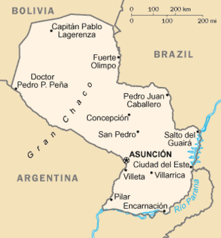
Paraguay is a country in South America, bordering Argentina, Bolivia and Brazil. The Paraguay River divides the country into strikingly different eastern and western regions. Both the eastern region and the western region gently slope toward and are drained into the Paraguay River, which separates and unifies the two regions. With the Paraneña region reaching southward and the Chaco extending to the north, Paraguay straddles the Tropic of Capricorn and experiences both subtropical and tropical climates.

<span class="mw-page-title-main">Geography of the United States</span>

The term "United States," when used in the geographical sense, refers to the contiguous United States, the state of Alaska, the island state of Hawaii, the five insular territories of Puerto Rico, Northern Mariana Islands, U.S. Virgin Islands, Guam, and American Samoa, and minor outlying possessions. The United States shares land borders with Canada and Mexico and maritime borders with Russia, Cuba, The Bahamas, and many other countries, mainly in the Caribbeanin addition to Canada and Mexico. The northern border of the United States with Canada is the world's longest bi-national land border.

<span class="mw-page-title-main">Geography of Ethiopia</span> Overview of geography of Ethiopia

Ethiopia is located in the Horn of Africa. It is bordered by Eritrea to the north, Djibouti and Somalia to the east, Sudan and South Sudan to the west, and Kenya to the south. Ethiopia has a high central plateau, the Abyssinian Highlands that varies from 1,290 to 3,000 m above sea level, with some 25 mountains whose peaks rise over 4,000 meters (13,200ft), the highest being Ras Dashen at 4,543 meters (14,538ft).

<span class="mw-page-title-main">Prairie</span> Ecosystems considered part of the temperate grasslands, savannas, and shrublands biome

Prairies are ecosystems considered part of the temperate grasslands, savannas, and shrublands biome by ecologists, based on similar temperate climates, moderate rainfall, and a composition of grasses, herbs, and shrubs, rather than trees, as the dominant vegetation type. Temperate grassland regions include the Pampas of Argentina, Brazil and Uruguay, and the steppe of Ukraine, Russia and Kazakhstan. Lands typically referred to as "prairie" tend to be in North America. The term encompasses the area referred to as the Interior Lowlands of Canada, the United States, and Mexico, which includes all of the Great Plains as well as the wetter, hillier land to the east.

<span class="mw-page-title-main">Intermontane Plateaus</span> Physiographic region of the contiguous United States

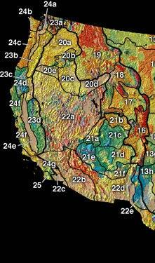
In the context of physical geography, the Intermontane Plateaus is one of eight physiographic regions of the contiguous United States. The region consists mostly of plateaus and mountain ranges lying between the Rocky Mountains on the east and the Cascade and Sierra Nevada Mountains on the west. It is subdivided into three physiographic provinces: the Columbia Plateau in the north, the Basin and Range Province in the central and southwestern portions, and the Colorado Plateau in the southeast. In turn, each of these provinces are each subdivided into a number of physiographic sections.

<span class="mw-page-title-main">Ozarks</span> Highland region in central-southern United States

The Ozarks, also known as the Ozark Mountains, Ozark Highlands or Ozark Plateau, is a physiographic region in the U.S. states of Missouri, Arkansas, Oklahoma and the extreme southeastern corner of Kansas. The Ozarks cover a significant portion of northern Arkansas and most of the southern half of Missouri, extending from Interstate 40 in central Arkansas to Interstate 70 in central Missouri.

<span class="mw-page-title-main">St. Francois Mountains</span> Mountain range in Missouri, United States

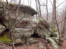
The St. Francois Mountains in southeast Missouri are a mountain range of Precambrian igneous mountains rising over the Ozark Plateau. This range is one of the oldest exposures of igneous rock in North America. The name of the range is spelled out as Saint Francois Mountains in official GNIS sources, but it is sometimes misspelled in use as St. Francis Mountains to match the anglicized pronunciation of both the range and St. Francois County.

<span class="mw-page-title-main">Catskill Mountains</span> Mountains in southeastern New York State, U.S.

The Catskill Mountains, also known as the Catskills, are a physiographic province and subrange of the larger Appalachian Mountains, located in southeastern New York. As a cultural and geographic region, the Catskills are generally defined as those areas close to or within the borders of the Catskill Park, a 700,000-acre (2,800 km2) forest preserve protected from many forms of development under New York state law.

The Highland Rim is a geographic term for the area in Tennessee, North Alabama, and Kentucky which surrounds the Central Basin. Geologically, the Central Basin is a dome. The Highland Rim is a cuesta surrounding the basin, and the border where the difference in elevation is sharply pronounced is an escarpment.

<span class="mw-page-title-main">Gulf Coastal Plain</span> Coastal Plain in the Southern United States and Eastern Mexico

The Gulf Coastal Plain extends around the Gulf of Mexico in the Southern United States and eastern Mexico.

<span class="mw-page-title-main">Driftless Area</span> Geological region in the Midwestern US

The Driftless Area, also known as Bluff Country and the Paleozoic Plateau, is a topographical and cultural region in the Midwestern United States that comprises southwestern Wisconsin, southeastern Minnesota, northeastern Iowa, and the extreme northwestern corner of Illinois. The Driftless Area is a USDA Level III Ecoregion: Ecoregion 52. The Driftless Area takes up a large portion of the Upper Midwest forest–savanna transition. The Blufflands refers to the eastern section of the Driftless area in Minnesota, due to the steep bluffs and cliffs around the river valleys. The western half is known as the Rochester Plateau, which is flatter than the Blufflands. The Coulee Region refers to the southwestern part of the Driftless Area in Wisconsin. It is named for its numerous ravines.

<span class="mw-page-title-main">Dissected Till Plains</span> Physiographic section of the central United States

The Dissected Till Plains are physiographic sections of the Central Lowlands province, which in turn is part of the Interior Plains physiographic division of the United States, located in southern and western Iowa, northeastern Kansas, the southwestern corner of Minnesota, northern Missouri, eastern Nebraska, and southeastern South Dakota.

<span class="mw-page-title-main">Gasconade River</span> River in central Missouri

The Gasconade River is about 280 miles (450 km) long and is located in central and south-central Missouri.

<span class="mw-page-title-main">Geography of North Dakota</span>

The Geography of North Dakota consists of three major geographic regions: in the east is the Red River Valley, west of this, the Missouri Plateau. The southwestern part of North Dakota is covered by the Great Plains, accentuated by the Badlands. There is also much in the way of geology and hydrology.

<span class="mw-page-title-main">Great Escarpment, Southern Africa</span> Major topographical feature in southern Africa

The Great Escarpment is a major topographical feature in Africa that consists of steep slopes from the high central Southern African plateau downward in the direction of the oceans that surround southern Africa on three sides. While it lies predominantly within the borders of South Africa, in the east the escarpment extends northward to form the border between Mozambique and Zimbabwe, continuing on beyond the Zambezi river valley to form the Muchinga Escarpment in eastern Zambia. In the west, it extends northward into Namibia and Angola. It is the combination of this escarpment and the aridity of Southern Africa that leads to the lack of navigable rivers in South Africa.

<span class="mw-page-title-main">Geology of Kansas</span>

The geology of Kansas encompasses the geologic history and the presently exposed rock and soil. Rock that crops out in the US state of Kansas was formed during the Phanerozoic eon, which consists of three geologic eras: the Paleozoic, Mesozoic and Cenozoic. Paleozoic rocks at the surface in Kansas are primarily from the Mississippian, Pennsylvanian, and Permian periods.

The U.S. state of Tennessee is geographically diverse, with varying terrains and several distinct physiographic regions. Its landforms range from the Blue Ridge Mountains in the eastern part of the state to flat and fertile plains along the Mississippi River. The state is geographically, legally, culturally, and economically divided into three Grand Divisions: East Tennessee, Middle Tennessee, and West Tennessee.

<span class="mw-page-title-main">Ozark Highlands (ecoregion)</span>

The Ozark Highlands is a Level III ecoregion designated by the Environmental Protection Agency (EPA) in four U.S. states. Most of the region is within Missouri, with a part in Arkansas and small sections in Oklahoma and Kansas. It is the largest subdivision of the region known as the Ozark Mountains, less rugged in comparison to the Boston Mountains in Arkansas, the highest part of the Ozarks.

References

  1. "Missouri Weather And Climate". Archived from the original on May 5, 2011. Retrieved July 17, 2007.

Wikisource-logo.svg This article incorporates text from a publication now in the public domain :  Chisholm, Hugh, ed. (1911). "Missouri". Encyclopædia Britannica . Vol. 13 (11th ed.). Cambridge University Press. pp. 607–614. (See p. 608.)