Geography of Florida

Last updated
A map of Florida, as seen from outer space. ISS062-E-69460 - View of Florida.jpg
A map of Florida, as seen from outer space.

Much of the state of Florida is situated on a peninsula between the Gulf of Mexico, the Atlantic Ocean, and the Straits of Florida. Spanning two time zones, it extends to the northwest into a panhandle along the northern Gulf of Mexico. It is bordered on the north by the states of Georgia and Alabama, on the west, at the end of the panhandle, by Alabama. It is near The Bahamas, and several Caribbean countries, particularly Cuba. Florida has 131 public airports, and more than 700 private airports, airstrips, heliports, and seaplane bases. [1] Florida is one of the largest states east of the Mississippi River, and only Alaska and Michigan are larger in water area.

Contents

Physiogeography

Florida has three distinct physiographic provinces: Gulf Coastal Lowlands, Atlantic Coastal Lowlands, and Interior Highlands. The coastal lowlands rim the entirety of the peninsula and panhandle from the shoreline to 30 to 50 miles (48 to 80 km) inland, merging with the Interior Highland. [2]

Terrain

BahiaHonda.jpg
Crandon Park Modified.jpg
The beach at Bahia Honda in the Florida Keys, and Crandon Park in Key Biscayne.

At 345 feet (105 m) above mean sea level, Britton Hill in northern Walton County is the highest point in Florida and the lowest known highpoint of any U.S. state. [3] Much of the state south of Orlando is low-lying and fairly level; however, some places, such as Clearwater, feature vistas that rise 50 to 100 feet (15 to 30 m) above the water. Much of Central and North Florida, typically 25 miles (40 km) or more away from the coastline, features rolling hills with elevations ranging from 100 to 250 feet (30 to 76 m). The most prominent topographic feature on the Florida Peninsula is the Lake Wales Ridge, a narrow sand ridge that runs north to south down the center of peninsular Florida. [4] The highest point on the Ridge and in peninsular Florida, Sugarloaf Mountain, is a 312-foot (95 m) peak in Lake County. [5] Much of Florida has an elevation of less than 12 feet (3.7 m), including many populated areas such as Miami which are located on the coast. Miami and other parts of south Florida are the most vulnerable regions in the world to rising sea levels associated with climate change. [6] Due to the vast amounts of limestone bedrock that Florida sits above, water is allowed to move relatively freely beneath dry land and to rise up to the surface. Water will also likely encroach from the Atlantic Coast and the Gulf Coast, and up through the Everglades, endangering the plant biomass within its marsh communities. [7]

A 2014 study found Florida to be the flattest state. [8]

Boundaries

The state line begins in the Atlantic Ocean, traveling west, south, and north up the thalweg of the Saint Mary's River. At the origin of that river, it then follows a straight line nearly due west and slightly north, to the point where the confluence of the Flint River (from Georgia) and the Chattahoochee River (down the Alabama/Georgia line) used to form Florida's Apalachicola River. (Since Woodruff Dam was built, this point has been under Lake Seminole.) The border with Georgia continues north through the lake for a short distance up the former thalweg of the Chattahoochee, then with Alabama runs due west along 31°N to the Perdido River, then south along its thalweg to the Gulf via Perdido Bay. Much of the state is at or near sea level. Florida is also 65,755 square miles.

Topography

Topographic map of Florida Florida topographic map-en.svg
Topographic map of Florida

Geology

The Florida peninsula is a porous plateau of karst limestone sitting atop bedrock known as the Florida Platform. The emergent portion of the platform was created during the Eocene to Oligocene as the Gulf Trough filled with silts, clays, and sands. Flora and fauna began appearing during the Miocene. No land animals were present in Florida prior to the Miocene.

The largest deposits of phosphate rock in the country are found in Florida. [9]

Extended systems of underwater caves, sinkholes and springs are found throughout the state and supply most of the water used by residents. The limestone is topped with sandy soils deposited as ancient beaches over millions of years as global sea levels rose and fell. During the last glacial period, lower sea levels and a drier climate revealed a much wider peninsula, largely savanna. [10] The Everglades, a wide, slow-flowing river, encompasses the southern tip of the peninsula.

While there are sinkholes in much of the state, modern sinkholes have tended to be in West-Central Florida. [11] [12]

Florida is tied for last place (with North Dakota) as having the fewest earthquakes of any US state. [13] Because Florida is not located near any tectonic plate boundaries, earthquakes are very rare, but not totally unknown. In January, 1879, a shock occurred near St. Augustine. There were reports of heavy shaking that knocked plaster from walls and articles from shelves. Similar effects were noted at Daytona Beach 50 miles (80 km) south. The tremor was felt as far south as Tampa and as far north as Savannah, Georgia.[ citation needed ] In January 1880, Cuba was the center of two strong earthquakes that sent severe shock waves through the city of Key West, Florida. (See List of earthquakes in Cuba) Another earthquake centered outside Florida was the 1886 Charleston earthquake. The shock was felt throughout northern Florida, ringing church bells at St. Augustine and severely jolting other towns along that section of Florida's east coast. Jacksonville residents felt many of the strong aftershocks that occurred in September, October, and November 1886. [14] As recently as 2006, a magnitude 6.0 earthquake centered about 260 miles (420 km) southwest of Tampa in the Gulf of Mexico sent shock waves through southwest and central Florida. The earthquake was too small to trigger a tsunami and no damage was reported. [15]

Climate

Koppen climate classification map of Florida. Florida Koppen.svg
Köppen climate classification map of Florida.

The climate of Florida is tempered by the fact that no part of the state is very distant from the ocean. North of Lake Okeechobee, the prevalent climate is humid subtropical, while coastal areas south of the lake (including the Florida Keys) have a true tropical climate. [16] Mean high temperatures for late July are primarily in the low 90s Fahrenheit (32–34 °C). Mean low temperatures for early to mid January range from the low 40s Fahrenheit (4–7 °C) in northern Florida to the mid-50s (≈13 °C) in southern Florida.

Royal Poinciana tree in full bloom in the Florida Keys, an indication of South Florida's tropical climate Royal Poinciana.jpg
Royal Poinciana tree in full bloom in the Florida Keys, an indication of South Florida's tropical climate
South Florida's climate is ideal for growing sugarcane. Sugar cane madeira hg.jpg
South Florida's climate is ideal for growing sugarcane.

In the summer, high temperatures in the state seldom exceed 100 °F (38 °C). During the late autumn and winter months, Florida has experienced occasional cold fronts that can bring high winds and relatively cooler temperatures for the entire state, with high temperatures that could remain into the 40s and 50s (4 to 15 °C) and lows in the 20s and 30s (−7 to 4 °C). Several record cold maxima have been in the 30s °F (−1 to 4 °C) and record lows have been in the 10s (−12 to −7 °C). These temperatures normally extend at most a few days at a time in the northern and central parts of Florida. Southern Florida, however, rarely encounters sub-freezing temperatures. The hottest temperature ever recorded in Florida was 109 °F (43 °C), which was set on June 29, 1931, in Monticello. The coldest temperature was −2 °F (−19 °C), on February 13, 1899, just 25 miles (40 km) away, in Tallahassee. The USDA Plant hardiness zones for the state range from zone 8a (no colder than 10 °F (−12 °C) ) in the Crestview to zone 10b (no colder than 35 °F (2 °C) ) in Southeast Florida in 1990. [17] Miami Beach and the keys are Zone 11.

Fall foliage in North Florida Lake Alice Winter.jpg
Fall foliage in North Florida

The seasons in Florida are determined more by precipitation than by temperature, with the hot, wet springs and summers making up the wet season, and mild to cool, and the relatively dry winters and autumns, making the dry season. Fall foliage appears in Central and North Florida starting around late November, and into winter. During El Niño there is greater rainfall between November and March.

At the end of El Niño in 1998, 480 wildfires occurred.

The Florida Keys, because they are completely surrounded by water, have lesser variability in temperatures. At Key West, temperatures rarely exceed 95 °F (35 °C) in the summer or fall below 55 °F (13 °C) in the winter, and frost has never been reported in the Keys.

Average high and low temperatures for various Florida cities (°F)
CityJanFebMarAprMayJunJulAugSepOctNovDec
Jacksonville [18] 65/4368/4574/5080/5686/6490/7092/7391/7387/7080/6173/5166/44
Key West [19] 75/6576/6679/6982/7285/7688/7889/8090/8088/7885/7680/7176/67
Melbourne [20] 72/5173/5377/5781/6185/6788/7190/7390/7388/7283/6778/6073/53
Miami [21] 76/6077/6180/6483/6886/7288/7590/7790/7788/7685/7281/6777/62
Orlando [22] 72/5075/5279/5684/6188/6691/7292/7392/7490/7285/6678/5874/53
Pensacola [23] 61/4364/4670/5176/5884/6689/7290/7490/7487/7080/6070/5063/45
Tallahassee [24] 64/4067/4273/4880/5387/6291/6991/7291/7288/6881/5772/4766/41
Tampa [25] 71/5172/5277/5782/6288/6890/7390/7590/7589/7384/6677/5872/52

Severe weather

Typical summer afternoon shower from the Everglades traveling eastward over Downtown Miami Miamisummershower.png
Typical summer afternoon shower from the Everglades traveling eastward over Downtown Miami

Florida's nickname is the "Sunshine State", but severe weather is a common occurrence in the state. Central Florida is known as the lightning capital of the United States, as it experiences more lightning strikes than anywhere else in the country. [26] Florida has the highest average precipitation of any state, in large part because afternoon thunderstorms are common in most of the state from late spring until early autumn. A fair day may be interrupted with a storm, only to return to sunshine an hour or so later. These thunderstorms, caused by overland collisions of moist masses of air from the Gulf of Mexico and Atlantic Ocean[ citation needed ], pop up in the early afternoon and can bring heavy downpours, high winds, and sometimes, tornadoes. Florida leads the United States in tornadoes per square mile (when including waterspouts), [27] but they do not typically reach the intensity of those in the Midwest and Great Plains. Hail often accompanies the most severe thunderstorms.

A narrow eastern part of the state including Orlando and Jacksonville receives between 2,400 and 2,800 hours of sunshine annually. The rest of the state, including Miami, receives between 2,800 and 3,200 hours annually. [28]

Snow is very uncommon in Florida, but has occurred in every major Florida city at least once; snow does fall very occasionally in North Florida Jacksonville Snow 2.jpg
Snow is very uncommon in Florida, but has occurred in every major Florida city at least once; snow does fall very occasionally in North Florida

Snow in Florida is a rare occurrence, especially on the peninsula. During the Great Blizzard of 1899, Florida experienced blizzard conditions; the Tampa Bay area had "gulf-effect" snow, similar to lake-effect snow in the Great Lakes region. [29] During the 1899 blizzard was the only time the temperature in Florida is known to have fallen below 0 degrees Fahrenheit (−18 °C). The most widespread snowfall in Florida history occurred on January 19, 1977, when snow fell over much of the state, with flurries as far south as Homestead. Snow flurries also fell on Miami Beach for the only time in recorded history. A hard freeze in 2003 brought "ocean-effect" snow flurries to the Atlantic coast as far south as Cape Canaveral. [30] The 1993 Superstorm brought blizzard conditions to the panhandle, while heavy rain and tornadoes beset the peninsula. The storm is believed to have been similar in composition to a hurricane, some Gulf coast regions even seeing storm surges of six feet or more. More recently, traces of snow and sleet fell across central Florida during a hard freeze event in January, 2010. There was some slight accumulation north of the I-4 corridor, mostly in the form of sleet. [31]

Hurricanes

Hurricane Andrew bearing down on Florida on August 23, 1992 Andrew 1992-08-23 1231Z.jpg
Hurricane Andrew bearing down on Florida on August 23, 1992

Hurricanes pose a severe threat during hurricane season, which lasts from June 1 to November 30, although some storms have been known to form out of season. Florida is the most hurricane-prone US state, with subtropical or tropical water on a lengthy coastline. From 1851 to 2006, Florida has been struck by 114 hurricanes, 37 of them major—category 3 and above. [32] It is rare for a hurricane season to pass without any impact in the state by at least a tropical storm. For storms, category 4 or higher, 83% have either hit Florida or Texas. [32] August to October is the most likely period for a hurricane in Florida.

In 2004, Florida was hit by a record four hurricanes. Hurricanes Charley (August 13), Frances (September 4–5), Ivan (September 16), and Jeanne (September 25–26) cumulatively cost the state's economy $42 billion. [33] In 2005, Hurricane Dennis (July 10) became the fifth storm to strike Florida within eleven months. Later, Hurricane Katrina (August 25) passed through South Florida and Hurricane Rita (September 20) swept through the Florida Keys. Hurricane Wilma (October 24) made landfall near Cape Romano, just south of Marco Island, finishing another very active hurricane season. Wilma is the second most expensive hurricane in Florida history, due in part to a five-year window in which to file claims. [34]

Florida was the site of the second costliest weather disaster in U.S. history, Hurricane Andrew, which caused more than US$25 billion in damage when it struck on August 24, 1992. In a long list of other infamous hurricane strikes are the 1926 Miami hurricane, the 1928 Okeechobee hurricane, the Labor Day Hurricane of 1935, Hurricane Donna in 1960, Hurricane Opal in 1995, and Hurricane Michael in 2018. A 2005 US government report suggests the storms are part of a natural cycle and not a result of global warming, [35] [36] but that report has been criticized as having been politicized. [37] [38]

Fauna

Florida is host to many types of wildlife including:

Alligator in the Florida Everglades Anhingatrailalligator.png
Alligator in the Florida Everglades
Key deer in the lower Florida Keys Key deer male.jpg
Key deer in the lower Florida Keys
The Florida scrub jay is found only in Florida Florida Scrub Jay.jpg
The Florida scrub jay is found only in Florida

The only known calving area for the northern right whale is off the coasts of Florida and Georgia. [40]

Since their accidental importation from South America into North America in the 1930s, the red imported fire ant population has increased its territorial range to include most of the Southern United States, including Florida. They are more aggressive than most native ant species and have a painful sting. [41]

A number of non-native snakes have been released in the wild. In 2010 the state created a hunting season for Burmese and Indian pythons, African rock pythons, green anacondas, and Nile monitor lizards. [42]

Political geography

History

Florida's extensive coastline made it a perceived target during World War II, so the government built airstrips throughout the state; today, approximately 400 airports are still in service. [1]

See also

Related Research Articles

<span class="mw-page-title-main">Gulf Coast of the United States</span> Coastline in the United States

The Gulf Coast of the United States, also known as the Gulf South or the South Coast, is the coastline along the Southern United States where they meet the Gulf of Mexico. The coastal states that have a shoreline on the Gulf of Mexico are Texas, Louisiana, Mississippi, Alabama, and Florida, and these are known as the Gulf States.

<span class="mw-page-title-main">Geography of the United States</span>

The term "United States," when used in the geographical sense, refers to the contiguous United States, Alaska, Hawaii, the five insular territories of Puerto Rico, Northern Mariana Islands, U.S. Virgin Islands, Guam, American Samoa, and minor outlying possessions. The United States shares land borders with Canada and Mexico and maritime borders with Russia, Cuba, The Bahamas, and many other countries, mainly in the Caribbeanin addition to Canada and Mexico. The northern border of the United States with Canada is the world's longest bi-national land border.

<span class="mw-page-title-main">East Coast of the United States</span> Atlantic coastal region of the United States

The East Coast of the United States, also known as the Eastern Seaboard, the Atlantic Coast, and the Atlantic Seaboard, is the region encompassing the coastline where the Eastern United States meets the Atlantic Ocean. The Thirteen Colonies, which formed the United States in 1776 were located on this coast, and it has played an important role in the development of the United States.

<span class="mw-page-title-main">Great Blizzard of 1899</span> 1899 blizzard in the United States

The Great Blizzard of 1899, also known as the Great Arctic Outbreak of 1899 and the St. Valentine's Day Blizzard, was an exceptionally severe winter weather event that affected most of the United States, particularly east of the Rocky Mountains. On February 11, Swift Current in present-day Saskatchewan reported a record-high barometric pressure of 31.42 inches of mercury (1,064 mb). While there was heavy snow during this event, the 1899 storm was most noted for the record cold it brought to several areas of the USA, including the first below zero (F) temperature ever recorded in Florida (Tallahassee in extreme northwest Florida recorded - 2 F.

<span class="mw-page-title-main">United States rainfall climatology</span> Characteristics of weather in U.S.

The characteristics of United States rainfall climatology differ significantly across the United States and those under United States sovereignty. Summer and early fall bring brief, but frequent thundershowers and tropical cyclones which create a wet summer and drier winter in the eastern Gulf and lower East Coast. During the winter, and spring, Pacific storm systems bring Hawaii and the western United States most of their precipitation. Low pressure systems moving up the East Coast and through the Great Lakes, bring cold season precipitation to from the Midwest to New England, as well as Great Salt Lake. The snow to liquid ratio across the contiguous United States averages 13:1, meaning 13 inches (330 mm) of snow melts down to 1 inch (25 mm) of water.

The climate of Houston is classified as a humid subtropical climate, with tropical influences. August normally ranks as the warmest month at an average temperature of 84.6 °F (29.2 °C) and January the coldest month at an average temperature of 53.1 °F (11.7 °C).

<span class="mw-page-title-main">Snow in Florida</span> Snow events in Florida, USA

It is very rare for snow to fall in the U.S. state of Florida, especially in the central and southern portions of the state. With the exception of the far northern areas of the state, most of the major cities in Florida have never recorded measurable snowfall, though trace amounts have been recorded, or flurries in the air observed few times each century. According to the National Weather Service, in the Florida Keys and Key West there is no known occurrence of snow flurries since the European colonization of the region more than 300 years ago. In Miami, Fort Lauderdale, and Palm Beach there has been only one known report of snow flurries observed in the air in more than 200 years; this occurred in January 1977. In any event, Miami, Fort Lauderdale, and Palm Beach have not seen snow flurries before or since this 1977 event.

<span class="mw-page-title-main">Climate of Florida</span> Climate

The climate of the north and central parts of the US state of Florida is humid subtropical. South Florida has a tropical climate. There is a defined rainy season from May through October when air mass thundershowers that build in the heat of the day drop heavy but brief summer rainfall.

<span class="mw-page-title-main">Tropical Storm Barry (2007)</span> Atlantic tropical cyclone

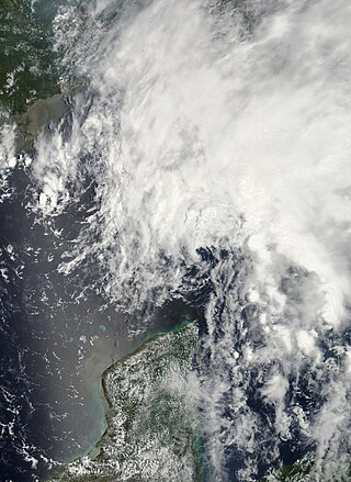
Tropical Storm Barry was a rapidly forming tropical cyclone that made landfall on Florida, United States, in early June 2007. The second named storm of the 2007 Atlantic hurricane season, Barry developed from a trough of low pressure in the southeastern Gulf of Mexico on June 1. It tracked rapidly northeastward, reaching peak winds of 60 mph (97 km/h) before weakening and making landfall near Tampa Bay as a tropical depression. Barry quickly lost tropical characteristics after wind shear removed much of the convection, and early on June 3, it completed the transition into an extratropical cyclone. The extratropical remnants tracked up the East Coast of the United States, and were absorbed by a larger extratropical cyclone on June 5.

<span class="mw-page-title-main">Climate of Alaska</span> Overview of the climate of the U.S. state of Alaska

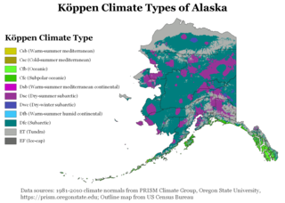
The climate of Alaska is determined by average temperatures and precipitation received statewide over many years. The extratropical storm track runs along the Aleutian Island chain, across the Alaska Peninsula, and along the coastal area of the Gulf of Alaska which exposes these parts of the state to a large majority of the storms crossing the North Pacific. The climate in Juneau and the southeast panhandle is a mid-latitude oceanic climate, in the southern sections and a subarctic oceanic climate in the northern parts. The climate in Southcentral Alaska is a subarctic climate due to its short, cool summers. The climate of the interior of Alaska is best described as extreme and is the best example of a true subarctic climate, as the highest and lowest recorded temperatures in Alaska have both occurred in the interior. The climate in the extreme north of Alaska is an Arctic climate with long, cold winters, and cool summers where snow is possible year-round.

<span class="mw-page-title-main">Climate of Georgia (U.S. state)</span> Overview of the climate of the U.S. state of Georgia

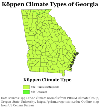
The climate of Georgia is a humid subtropical climate, with most of the state having short, mild winters and long, hot summers. The Atlantic Ocean on the east coast of Georgia and the hill country in the north impact the state's climate. Also, the Chattahoochee River divides Georgia into separate climatic regions with the mountain region to the northwest being cooler than the rest of the state; the average temperatures for the mountain region in January and July are 39 °F (4 °C) and 78 °F (26 °C) respectively. Winter in Georgia is characterized by mild temperatures and little snowfall around the state, with the potential for snow and ice increasing in the northern parts of the state. Summer daytime temperatures in Georgia often exceed 95 °F (35 °C). The state experiences widespread precipitation. Tornadoes and tropical cyclones are common.

<span class="mw-page-title-main">Climate of the United States</span> Varies due to changes in latitude, and a range of geographic features

The climate of the United States varies due to changes in latitude, and a range of geographic features, including mountains and deserts. Generally, on the mainland, the climate of the U.S. becomes warmer the further south one travels, and drier the further west, until one reaches the West Coast.

<span class="mw-page-title-main">Climate of North Carolina</span> Overview of the climate of the U.S. state of North Carolina

North Carolina's climate varies from the Atlantic coast in the east to the Appalachian Mountain range in the west. The mountains often act as a "shield", blocking low temperatures and storms from the Midwest from entering the Piedmont of North Carolina.

<span class="mw-page-title-main">Climate of South Carolina</span> Overview of the climate of the U.S. state of South Carolina

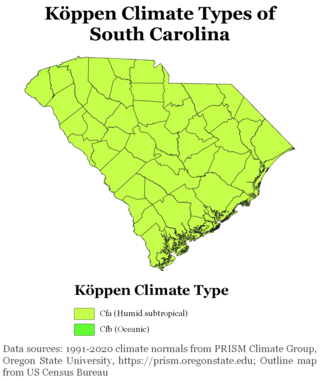
South Carolina has a humid subtropical climate, with hot summers throughout most of the state. But, an exception does occur in the Blue Ridge Mountains, as outlier pockets of an Oceanic Climate do exist. Mild winters predominate in the eastern and southern part of the state, but cool to occasionally cold winters are the standard in the northwestern area of the state, especially areas at or above 600 feet in elevation. On average, between 40 and 80 inches of precipitation falls annually across the state, potentially even in excess of 100 inches in portions of the Appalachian temperate rainforest. Tropical cyclones, and afternoon thunderstorms due to hot and humid conditions, contribute to precipitation during the summer and sometimes fall months, while extratropical cyclones contribute to precipitation during the fall, winter, and spring months. The coast experiences nearly all of their tropical weather impacts from storms coming directly from the Atlantic coast. The northwestern area of the state can receive impacts from both Atlantic basin storms moving westward from the coast and also occasionally very heavy rainfall and flooding from storms originating from the Gulf of Mexico that move inland towards the northeast after making landfall from the Florida Panhandle to Louisiana.

<span class="mw-page-title-main">Climate of the Tampa Bay area</span>

The Tampa Bay area has a humid subtropical climate, closely bordering a tropical climate near the waterfront areas. There are two basic seasons in the Tampa Bay area, a hot and wet season from May through October, and a mild and dry season from November through April.

<span class="mw-page-title-main">Climate of Miami</span> Overview of the climate of Miami

The climate of Miami is classified as having a tropical monsoon climate with hot and humid summers; short, warm winters; and a marked drier season in the winter. Its sea-level elevation, coastal location, position just above the Tropic of Cancer, and proximity to the Gulf Stream shape its climate.

<span class="mw-page-title-main">Geology of Florida</span> Overview of the geology of the U.S. state of Florida

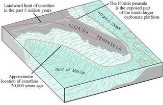
The Floridian peninsula is a porous plateau of karst limestone sitting atop bedrock known as the Florida Platform. The emergent portion of the platform was created during the Eocene to Oligocene as the Gulf Trough filled with silts, clays, and sands. Flora and fauna began appearing during the Miocene. No land animals were present in Florida prior to the Miocene.

<span class="mw-page-title-main">2020 Atlantic hurricane season</span> Hurricane season in the Atlantic Ocean

The 2020 Atlantic hurricane season was the most active Atlantic hurricane season on record, in terms of number of systems. It featured a total of 31 tropical or subtropical cyclones, with all but one cyclone becoming a named storm. Of the 30 named storms, 14 developed into hurricanes, and a record-tying seven further intensified into major hurricanes. It was the second and final season to use the Greek letter storm naming system, the first being 2005, the previous record. Of the 30 named storms, 11 of them made landfall in the contiguous United States, breaking the record of nine set in 1916. During the season, 27 tropical storms established a new record for earliest formation date by storm number. This season also featured a record ten tropical cyclones that underwent rapid intensification, tying it with 1995, as well as tying the record for most Category 4 hurricanes in a singular season in the Atlantic Basin. This unprecedented activity was fueled by a La Niña that developed in the summer months of 2020, continuing a stretch of above-average seasonal activity that began in 2016. Despite the record-high activity, this was the first season since 2015 in which no Category 5 hurricanes formed.

<span class="mw-page-title-main">2021 Atlantic hurricane season</span> Hurricane season in the Atlantic Ocean

The 2021 Atlantic hurricane season was the third-most active Atlantic hurricane season on record in terms of number of tropical cyclones, although many of them were weak and short-lived. With 21 named storms forming, it became the second season in a row and third overall in which the designated 21-name list of storm names was exhausted. Seven of those storms strengthened into a hurricane, four of which reached major hurricane intensity, which is slightly above-average. The season officially began on June 1 and ended on November 30. These dates historically describe the period in each year when most Atlantic tropical cyclones form. However, subtropical or tropical cyclogenesis is possible at any time of the year, as demonstrated by the development of Tropical Storm Ana on May 22, making this the seventh consecutive year in which a storm developed outside of the official season.

<span class="mw-page-title-main">Hurricane Zeta</span> Category 3 Atlantic hurricane in 2020

Hurricane Zeta was a late-season major hurricane in 2020 that made landfall on the Yucatán Peninsula and then in southeastern Louisiana, the latest on record to do so at such strength in the United States. Zeta was the record-tying sixth hurricane of the year to make landfall in the United States. The twenty-seventh named storm, twelfth hurricane and fifth major hurricane of the extremely active 2020 Atlantic hurricane season, Zeta formed from a broad area of low pressure that formed in the western Caribbean Sea on October 19. After battling wind shear, the quasi-stationary low organized into Tropical Depression Twenty-Eight on October 24. The system strengthened into Tropical Storm Zeta early on October 25 before becoming a hurricane the next day as it began to move northwestward. Hurricane Zeta made landfall on the Yucatán Peninsula late on October 26 and weakened while inland to a tropical storm, before moving off the northern coast of the peninsula on October 27. After weakening due to dry air entrainment, Zeta reorganized and became a hurricane again, and eventually a Category 2 hurricane, as it turned northeastward approaching the United States Gulf Coast on October 28. It continued to strengthen until it reached its peak intensity as a major Category 3 hurricane with 115-mile-per-hour (185 km/h) sustained winds and a minimum pressure of 970 mbar (28.64 inHg) as it made landfall at Cocodrie, Louisiana, that evening. Zeta continued on through Mississippi and parts of Alabama with hurricane-force winds. Zeta gradually weakened as it accelerated northeastward, and became post-tropical on October 29, as it moved through central Virginia, dissipating shortly afterwards off the coast of New Jersey. After bringing accumulating snow to parts of New England, the extratropical low-pressure system carrying Zeta's remnant energy impacted the United Kingdom on November 1 and 2.

References

  1. 1 2 "Florida Drug Threat Assessment-Overview". National Drug Intelligence Center. Archived from the original on 2003-08-20. Retrieved 2007-07-18.
  2. Szary, William (March 16, 2021). Florida's Geologic Atlas: A guide to county geologic maps. Earth2Energy Educational Publishing. ISBN   979-8723792111.
  3. Main, Martin B.; Allen, Ginger M. (July 2007). "The Florida Environment: An Overview". University of Florida, Institute of Food and Agricultural Sciences. Archived from the original on 2008-07-24. Retrieved 2008-01-23.
  4. "Lake Wales Ridge". LandScope America. Retrieved 2021-07-23.
  5. "Green Mountain Scenic Byway". Florida Department of Transportation. Archived from the original on March 6, 2008. Retrieved 2008-01-23.
  6. Jeff Goodell (June 20, 2013). "Goodbye, Miami". Rolling Stone. Retrieved June 21, 2013.
  7. Fuller, Douglas; Wang, Yu (October 5, 2013). "Recent Trends in Satellite Vegetation Index Observations Indicate Decreasing Vegetation Biomass in the Southeastern Saline Everglades Wetland". Wetlands. 34 (1): 67–77. doi:10.1007/s13157-013-0483-0. S2CID   17631769.
  8. Dobson, Jerome E.; Campbell, Joshua S. (April 7, 2014). "The Flatness of U.S. States". Geographical Review . 104 (1): 1–9. Bibcode:2014GeoRv.104....1D. doi:10.1111/j.1931-0846.2014.12001.x. S2CID   121045088.
  9. "Industry overview". First research. www.hoovers.com. 2010-03-25. Archived from the original on February 14, 2010.
  10. Allen, Ginger M.; Main, Martin B (May 2005). "Florida's Geological History". Florida Cooperative Extension Service. University of Florida. Archived from the original on 2005-12-31. Retrieved 2009-01-20.
  11. Ann B. Tihansky. "Sinkholes, West-Central Florida" (PDF). Tampa, Florida: U.S. Geological Survey.
  12. "Florida Sinkhole Maps". Maps Etc. University of South Florida.
  13. Presler, Margaret Webb (14 April 2010). "More earthquakes than usual? Not really". Washington Post. Washington D.C. pp. C10.
  14. "Florida:Earthquake History". United States Geological Survey. Archived from the original on 2006-04-09. Retrieved 2007-12-03.
  15. "6.0 quake in Gulf shakes Southeast". CNN. September 11, 2006. Archived from the original on 2006-09-21. Retrieved 2007-12-03.
  16. Ritter, Michael. "Wet/Dry Tropical Climate". University of Wisconsin, Stevens Point. Archived from the original on 2004-01-15. Retrieved 2007-07-18.
  17. "Georgia USDA Plant Hardiness Zone Map" . Retrieved 2011-03-21.[ permanent dead link ]
  18. "JACKSONVILLE WSO AP, FLORIDA—Climate Summary". Southeast Regional Climate Center. Archived from the original on 2008-01-18. Retrieved 2008-01-26.
  19. "KEY WEST WSO AIRPORT, FLORIDA—Climate Summary". Southeast Regional Climate Center. Archived from the original on 2008-01-18. Retrieved 2008-01-26.
  20. "MELBOURNE WSO, FLORIDA—Climate Summary". Southeast Regional Climate Center. Archived from the original on 2008-01-18. Retrieved 2008-01-26.
  21. "MIAMI WSCMO AIRPORT, FLORIDA—Climate Summary". Southeast Regional Climate Center. Archived from the original on 2008-01-18. Retrieved 2008-01-26.
  22. "Climate".
  23. "PENSACOLA FAA ARPT, FLORIDA—Climate Summary". Southeast Regional Climate Center. Archived from the original on 2008-01-18. Retrieved 2008-01-26.
  24. "TALLAHASSEE WSO AP, FLORIDA—Climate Summary". Southeast Regional Climate Center. Archived from the original on 2008-01-18. Retrieved 2008-01-26.
  25. "TAMPA WSCMO ARPT, FLORIDA—Climate Summary". Southeast Regional Climate Center. Archived from the original on 2008-01-18. Retrieved 2008-01-26.
  26. "Lightning Information Center". National Weather Service. Archived from the original on 2000-05-16. Retrieved 2008-01-23.
  27. Aten, Tim (July 1, 2007). "Waterspouts common off coastal Florida in summer". Naples Daily News . Archived from the original on 2010-12-05. Retrieved 2008-01-23.
  28. "United States annual sunshine map". HowStuffWorks, Inc. Archived from the original on 2011-04-29. Retrieved 2011-03-14.
  29. James A. Henry, Kenneth Michael Portier, Jan Coyne, The Climate and Weather of Florida, Pineapple Press, 1994, p. 60. ISBN   978-1-56164-036-2.
  30. "Cold Temperatures and Snow Flurries in East-Central Florida". National Oceanic and Atmospheric Administration. Archived from the original on 2007-07-04. Retrieved 2007-07-18.
  31. "Sleet, Snow Fall In Parts Of Central Florida – News Story – WFTV Orlando". Wftv.com. 2010-01-09. Archived from the original on 2010-01-12. Retrieved 2010-08-02.
  32. 1 2 Doe (28 March 2009). "Florida is US lightning capital" (Document). Melbourne, Florida: Florida Today Factbook. p. 34.
  33. "Weather, politics shook things up". Florida Today. Melbourne, Florida. 31 December 2009. pp. 1A. Archived from the original on 22 February 2014.
  34. Read, Matt (2 February 2010). "Watchdog:Discounts may boost price for insurance". Florida Today. Melbourne, Florida. pp. 1B.[ dead link ]
  35. Than, Ker (August 31, 2005). "Many More Hurricanes To Come". Live Science. Archived from the original on 2007-07-14. Retrieved 2007-12-03.
  36. "NOAA Attributes Recent Increase In Hurricane Activity To Naturally Occurring Multi-Decadal Climate Variability". National Oceanic and Atmospheric Administration. Archived from the original on 2005-12-03. Retrieved 2007-12-03.
  37. "Hurricane Science Becomes a Matter of Policy as NOAA Takes Sides". Union of Concerned Scientists. Retrieved 2012-11-26.
  38. "NOAA's misleading internal Congressional briefing points on hurricanes and global warming". Climate Science Watch. Retrieved 2012-11-26.
  39. C. Michael Hogan. 2008. Wild turkey: Meleagris gallopavo, GlobalTwitcher.com, ed. N. Stromberg Archived 2017-07-25 at the Wayback Machine
  40. Waymer, Jim (28 December 2009). "Whale habitat could grow". Florida Today. Melbourne, Florida. pp. 1A. Archived from the original on 31 December 2009.
  41. "Not all alien invaders are from outer space". United States Department of Agriculture. Archived from the original on 2005-04-19. Retrieved 2007-12-03.
  42. "State creates season for hunting pythons". Florida Today. Melbourne, Florida. Associated Press. 23 February 2010. pp. 6B. Archived from the original on February 24, 2010.