Hurricane Ivan

Last updated

Map key
  Tropical depression (≤38 mph, ≤62 km/h)
  Tropical storm (39–73 mph, 63–118 km/h)
  Category 1 (74–95 mph, 119–153 km/h)
  Category 2 (96–110 mph, 154–177 km/h)
  Category 3 (111–129 mph, 178–208 km/h)
  Category 4 (130–156 mph, 209–251 km/h)
  Category 5 (≥157 mph, ≥252 km/h)
  Unknown
Storm type
Disc Plain black.svg Tropical cyclone
Solid black.svg Subtropical cyclone
ArrowUp.svg Extratropical cyclone, remnant low, tropical disturbance, or monsoon depression

On September 2, 2004, Tropical Depression Nine formed from a large tropical wave southwest of Cape Verde. As the system moved to the west, it strengthened gradually, becoming Tropical Storm Ivan on September 3, and reaching hurricane strength on September 5, 1,150 miles (1,850 km) to the east of Tobago. Later that day, the storm intensified rapidly, and by 5 p.m. EDT (UTC–4), Ivan became a Category 4 hurricane with winds of 130 miles per hour (210 km/h). The National Hurricane Center said that the rapid strengthening of Ivan on September 5 was unprecedented at such a low latitude in the Atlantic basin. [1] [2]

The eye of Hurricane Ivan as seen from the International Space Station on September 11, 2004. Hurricane Ivan ISS.jpg
The eye of Hurricane Ivan as seen from the International Space Station on September 11, 2004.

As it moved west, Ivan weakened slightly because of wind shear in the area. [3] The storm passed over Grenada on September 7, battering several of the Windward Islands. As it entered the Caribbean Sea, Ivan reintensified rapidly and became a Category 5 hurricane, just north of the Windward Netherlands Antilles (Curaçao and Bonaire) and Aruba on September 9, with winds reaching 160 mph (260 km/h). Ivan weakened slightly as it moved west-northwest towards Jamaica. As Ivan approached the island late on September 10, it began a westward jog that kept the eye and the strongest winds to the south and west. However, because of its proximity to the Jamaican coast, the island was battered with hurricane-force winds for hours. [1]

After passing Cuba, Ivan resumed a more northerly track and regained Category 5 strength. Ivan's strength continued to fluctuate as it moved west on September 11, and the storm attained its highest 1-minute maximum sustained winds of 165 mph (265 km/h) as it passed within 30 miles (50 km) of Grand Cayman. Ivan reached its peak strength with a minimum central pressure of 910 millibars (27 inHg) on September 12. Ivan passed through the Yucatán Channel late on September 13, while its eyewall affected the westernmost tip of Cuba. Once over the Gulf of Mexico, Ivan weakened slightly to Category 4 strength, which it maintained while approaching the Gulf Coast of the United States. [1] When Ivan entered the Gulf of Mexico, U.S. Naval Research Laboratory ocean-floor pressure sensors detected a freak wave, which was caused by the hurricane. The wave was around 91 feet (28 m) high from peak to trough, and around 660 feet (200 m) long. [4] Their computer models also indicated that waves may have exceeded 130 feet (40 m) in the eyewall. [5]

Hurricane Ivan at landfall in Baldwin County, Alabama on the U.S. Gulf Coast. IvanRadar-04Sep16-0650Z.gif
Hurricane Ivan at landfall in Baldwin County, Alabama on the U.S. Gulf Coast.

Just before it made landfall in the United States, Ivan's eyewall weakened considerably, and its southwestern portion almost disappeared.[ citation needed ] Around 2 a.m. CDT (UTC–5) on September 16, Ivan made landfall on the U.S. mainland in Gulf Shores, Alabama, as a Category 3 hurricane, with 1-minute sustained winds of 120 mph (190 km/h). Some hurricane information sources put the winds from Hurricane Ivan near 130 mph (210 km/h) (Category 4) upon landfall in Alabama and northwestern Florida. [6] [7] Ivan then continued inland, maintaining hurricane strength until it was over central Alabama. Ivan weakened rapidly that evening and became a tropical depression on the same day, still over Alabama. Ivan lost tropical characteristics on September 18 while crossing Virginia, becoming an extratropical storm. Later that day, the remnant low of Ivan drifted off the U.S. mid-Atlantic coast into the Atlantic Ocean, and the low-pressure disturbance continued to dump rain on the United States. [1]

On September 20, Ivan's remnant surface low completed an anticyclonic loop and moved across the Florida peninsula. As it continued westward across the northern Gulf of Mexico, the system reorganized and again took on tropical characteristics on September 22. [1] On September 22, the National Weather Service, "after considerable and sometimes animated in-house discussion [regarding] the demise of Ivan," [8] determined that the low was in fact a result of the remnants of Ivan and thus named it accordingly. On the evening of September 23, the revived Ivan made landfall near Cameron, Louisiana as a tropical depression. Ivan weakened into a remnant low on September 24, as it moved overland into Texas. [1] [9] The remnant circulation of Ivan persisted for another day, before dissipating on September 25. [10] [11]

Records

Ivan as a Category 3 hurricane, east of the Windwards on September 5, 2004. Ivan 2004-09-05 1330Z.jpg
Ivan as a Category 3 hurricane, east of the Windwards on September 5, 2004.

Ivan set 18 new records for intensity at low latitudes. When Ivan initially became a Category 1 hurricane on September 3, it was centered 9.5 degrees north from the equator. This is farthest south position on record for a hurricane in the Atlantic basin. [12] Later that day (6 p.m. UTC), when Ivan became a Category 3 hurricane, it was centered near 10.2 degrees north from the equator. This is the most southerly location on record for a major hurricane in the Atlantic basin. [1] Just six hours later, Ivan also became the most southerly Category 4 hurricane on record in the Atlantic basin when it reached that intensity while located at 10.6 degrees north. [13] Finally, at midnight (UTC) on September 9 while centered at 13.7 degrees north, Ivan became the most southerly Category 5 hurricane on record in the Atlantic basin. [13] The latter record would not be surpassed until Hurricane Matthew in 2016, which reached Category 5 intensity at 13.4 degrees north. [14]

Ivan had held the world record of 33 (with 32 consecutive) six-hour periods of intensity at or above Category 4 strength. This record was broken two years later by Pacific Hurricane/Typhoon Ioke, which had 36 (33 consecutive) six-hour periods at Category 4 strength. This contributed to Ivan's total Accumulated Cyclone Energy (ACE) of 70.38. [15] The tornado outbreak associated with Ivan spawned 127 tornadoes, more than any other tropical cyclone worldwide. [16] [17]

Scientists from the Naval Research Laboratory at Stennis Space Center, Mississippi have used a computer model to predict that, at the height of the storm, the maximum wave height within Ivan's eyewall reached 131 feet (40 m). [18]

Preparations

Satellite images of Hurricane Ivan in stages across the storm's path Hurricane Ivan (48711186578).gif
Satellite images of Hurricane Ivan in stages across the storm's path

Caribbean

By September 5, a hurricane watch was posted for Barbados. Early on the following day, a tropical storm watch was issued for Grenada. Later that day, hurricane watches were also put into effect for Saint Lucia, and Martinique. A tropical storm warning was issued for Saint Vincent and Grenadines and Tobago and Grenada. By 3 p.m. UTC on September 6, the hurricane watches and tropical storm watches and warnings were upgraded to a hurricane warning and expanded to: Barbados, Saint Vincent and Grenadines, Saint Lucia, Tobago, and Grenada. Simultaneously, a tropical storm warning was issued for Trinidad. On September 7, the hurricane warning in effect for several countries was downgraded to a tropical storm warning. By September, all tropical storm and hurricane watches and warnings were discontinued in the eastern portions of the Windward Islands. [1]

As Ivan continued westward, a hurricane watch was issued for the ABC islands on September 8. [1] Many schools and businesses were closed in the Netherlands Antilles, [19] and about 300 people evacuated their homes on Curaçao. [20]

In the Caribbean, 500,000  Jamaicans were told to evacuate from coastal areas, [21] but only 5,000 were reported to have moved to shelters. [22] 12,000 residents and tourists were evacuated from Isla Mujeres off the Yucatán Peninsula. [23]

United States

In Louisiana, mandatory evacuations of vulnerable areas in Jefferson, Lafourche, Plaquemines, St. Charles, St. James, St. John the Baptist, and Tangipahoa parishes took place, with voluntary evacuations ordered in six other parishes. More than one-third of the population of Greater New Orleans evacuated voluntarily, including more than half of the residents of New Orleans itself. At the height of the evacuation, intense traffic congestion on local highways caused delays of up to 12 hours. About a thousand special-needs patients were housed at the Louisiana Superdome during the storm. Ivan was considered a particular threat to the New Orleans area because dangers of catastrophic flooding. However, Plaquemines and St. Bernard Parishes suffered a moderate amount of wind damage. Hurricane preparedness for New Orleans was judged poor. [24] At one point, the media sparked fears of an "Atlantean" catastrophe if the hurricane were to make a direct strike on the city. [25] These fears were not realized, as the storm's path turned further east.

In Mississippi, evacuation of mobile homes and vulnerable areas took place in Hancock, Jackson, and Harrison counties. [26] In Alabama, evacuation in the areas of Mobile and Baldwin counties south of Interstate 10 was ordered, including a third of the incorporated territory of the City of Mobile, as well as several of its suburbs. [27] In Florida, a full evacuation of the Florida Keys began at 7 a.m. EDT September 10 but was lifted at 5 a.m. EDT September 13 as Ivan tracked further west than originally predicted. [28] Voluntary evacuations were declared in ten counties along the Florida Panhandle, with strong emphasis in the immediate western counties of Escambia, Santa Rosa, and Okaloosa. Ivan prompted the evacuation of 270 animals at the Alabama Gulf Coast Zoo in Gulf Shores, Alabama. The evacuation had to be completed within a couple of hours, with only 28 volunteers available to move the animals. [29]

Impact

Hurricane Ivan
Ivan 2004-09-13 1900Z (alternate).jpg
Ivan at peak intensity in the Yucatán Channel on September 13
Deaths and damage by country
CountryTotal
deaths
Direct
deaths
Damage
(2004 USD)
Refs
Barbados 11 [30]
Cayman Islands 20 [31] [32]
Cuba 00 [30]
Dominican Republic 44Unknown [1]
Grenada 3939 [30]
Jamaica 1717 [1]
Saint Lucia 00 [1]
Saint Vincent and the Grenadines 00 [1]
Trinidad and Tobago 11 [33]
United States 5425 [1] [34]
Venezuela 33Unknown [30]
Totals:12090 [1]

Ivan killed 64 people in the Caribbean—mainly in Grenada and Jamaica—three in Venezuela, and 25 in the United States, including fourteen in Florida. Thirty-two more deaths in the United States were indirectly attributed to Ivan. While traversing the eastern United States, Ivan spawned 120 tornadoes, striking communities along concentric arcs on the leading edge of the storm. [35] In Florida, Blountstown, Marianna, and Panama City Beach suffered three of the most devastating tornadoes. A Panama City Beach news station was nearly hit by an F2 tornado during the storm. [36] Ivan also caused over $20.5 billion (equivalent to $33 billion in 2023) in damages in the United States and $3 billion (equivalent to $5 billion in 2023) in the Caribbean.

Southeastern Caribbean and Venezuela

Aftermath of Hurricane Ivan in Grenada Grenada ivan.jpg
Aftermath of Hurricane Ivan in Grenada

Ivan was a large-sized and major hurricane upon moving through the Windward Islands, battering structures, uprooting trees and causing power outages across much of the island chain. Even though it passed well south of Barbados on September 6, potent winds damaged 531 homes to varying degree, while one person drowned due to flooding. Monetary losses on the island surmounted $5 million. [30] The worst of Ivan occurred in Grenada, when it passed directly over the island on September 7 with winds of over 135 mph (217 km/h). [37] The island, in the words of a Caribbean disaster official, suffered "total devastation." [38] At least 89% of the small islandor 28,000 of 31,000 homesexperienced damage. [37] The capital, St. George's, was severely damaged and several notable buildings were destroyed, including two largest hospitals in Grenada. [1] [39] In all, 41 people lost their lives during the hurricane, damage on the island totalled $830.7 million (equivalent to $1.34 billion in 2023), primarily to housing. [37] [1]

Lighter effects occurred in Trinidad and Tobago, with most of the damage confined to the smaller island of Tobago. Twenty villages on that island suffered various forms of damage, and at least 45 homes lost their roofs. [1] One person died from a fallen tree, and damage was estimated at $4.9 million. [30] [19] Further north, large waves and high storm surge battered the coastlines of Saint Vincent and the Grenadines, washing away 2 homes, destroying 19 and damaging 40. [1] [33] Significant damage was reported to local banana crop, [40] and losses for the country totaled $40 million. [1] Strong winds and rough surf affected southern portions of Saint Lucia, inflicting $2.6 million worth in damage to homes and crops. [1] [33] High waves from Ivan caused light damage to southwestern Martinique and Guadeloupe, and gale-force winds buffeted Dominica. [41] [1]

As Ivan continued to strengthen, it proceeded about 80 mi (130 km) north of the ABC Islands on September 9. High winds blew away roof shingles and produced large swells that battered several coastal facilities. A developing spiral band dropped heavy rainfall over Aruba, causing flooding and $1.1 million worth in structural damage. [42] [43]

Jamaica

On September 11–12, the center of Ivan passed near Jamaica, causing significant wind and flood damage. Overall, 17 people were killed in Jamaica and 18,000 people were left homeless as a result of the flood waters and high winds. [44] Most of the major resorts and hotels fared well, though, and were reopened only a few days after Ivan had passed. [45] Damage on Jamaica totaled $360 million (equivalent to $581 million in 2023). [1]

Cayman Islands

Damage from Ivan in the Cayman Islands. Cayman - Ivan damage.jpg
Damage from Ivan in the Cayman Islands.

In the Cayman Islands, Governor Bruce Dinwiddy described damage as "very, very severe and widespread." Despite strict building codes which made the islands' buildings well able to withstand even major hurricanes, Ivan's winds and storm surge were so strong that a quarter or more of the buildings on the islands were reported to be uninhabitable, with 85% damaged to some extent. Much of Grand Cayman still remained without power, water, or sewer services for several months later. After five months, barely half the pre-Ivan hotel rooms were usable. Two people were killed on Grand Cayman, one from drowning and the other from flying debris. [30] Damage across the territory was catastrophic, with losses amounting to $2.86 billion (equivalent to $4.61 billion in 2023) or 183 percent of its gross domestic product. [32] The Letter from the Cayman Islands Government Office in the United Kingdom, 8 October 2004 by McKeeva Bush, Leader of Government Business details the intensity, extent of damage, and recovery process during the months that followed. [46]

Elsewhere in the Caribbean

There were four deaths in the Dominican Republic. The region's Caribbean Development Bank estimates Ivan caused over $3 billion ($4.8 billion in 2023) damage on island nations, mostly in the Cayman Islands, Grenada, and Jamaica. [1] Minor damage, including some beach erosion, was reported in the ABC islands. [47]

Even though Ivan did not make landfall on Cuban soil, its storm surge caused localized flooding on Santiago de Cuba and Granma, on the southern part of the island. At Cienfuegos, the storm produced waves of 15 feet (4.6 m), and Pinar del Río recorded 13.3 inches (340 mm) of rainfall. While there were no casualties on the island, the Cuban government estimates that about $1.2 billion ($1.9 billion in 2023 USD) of property damage were directly due to Ivan. [30]

United States

Hurricane Ivan sank and stacked numerous boats at Bayou Grande Marina at NAS Pensacola. Hurricane Ivan2.jpg
Hurricane Ivan sank and stacked numerous boats at Bayou Grande Marina at NAS Pensacola.

Along with the 14 deaths in Florida, Ivan is blamed for eight deaths in North Carolina, two in Georgia, and one in Mississippi. An additional 32 deaths were reported as indirectly caused by the storm. [1]

As it passed over the Gulf of Mexico off the coast of Louisiana, Ivan caused the destruction of Taylor Energy's Mississippi Canyon 20-A production platform, [48] 550 ft (170 m) above 28 producing oil and gas wells drilled in water 479 ft (146 m) deep. Waves estimated to be 71 feet (22 m) caused tremendous pressures below the surface, causing a landslide that obliterated the platform. Hundreds of gallons of oil per day [49] were still leaking onto the surface of the Gulf fourteen years later. The United States Coast Guard reported that the spill had been contained in 2019. [50]

Ivan caused an estimated $20.5 billion (equivalent to $33.1 billion in 2023) in damage in the United States alone, making it the second-costliest hurricane on record at the time, behind only Hurricane Andrew of 1992. [51]

Florida

As Ivan made landfall on the U.S. coastline in eastern Alabama, there was heavy damage as observed in Pensacola, Gulf Breeze, Navarre Beach, and Pensacola Beach, dwellings situated far inland, as much as 20 miles (32 km) from the Gulf coast, along the shorelines of Escambia Bay, East Bay, Blackwater Bay, and Ward Basin in Escambia County and Santa Rosa County, and Fort Walton Beach, Florida on the eastern side of the storm. The area just west of Pensacola, including the community of Warrington (which includes Pensacola NAS), Perdido Key, and Innerarity Point, took the brunt of the storm. Some of the subdivisions in this part of the county were completely destroyed, with a few key roads in the Perdido area only opened in late 2005, over a year after the storm hit. Shattered windows from gusts and flying projectiles experienced throughout the night of the storm were common. As of December 2007, roads remained closed on Pensacola Beach because of damage from Ivan's storm surge. [52]

In Pensacola, the Interstate 10 Escambia Bay Bridge was heavily damaged, with as much as a quarter-mile (400 m) of the bridge collapsing into the bay. The causeway that carries U.S. Highway 90 across the northern part of the same bay was also heavily damaged. The U.S. 90 causeway reopened first; the I-10 bridge reopened, with temporary repairs, in November. Virtually all of Perdido Key, an area on the outskirts of Pensacola that bore the brunt of Ivan's winds and rain, was essentially leveled. High surf and wind brought extensive damage to Innerarity Point. [52]

On September 26, 2006, over two years after Ivan struck the region, funding for the last 501  FEMA-provided trailers ran out for those living in Santa Rosa and Escambia counties. [52]

Alabama

Damage from Ivan at the Bon Secour National Wildlife Refuge BonSecour04.jpg
Damage from Ivan at the Bon Secour National Wildlife Refuge

Alabama experienced the highest wind gust during Ivan. A sailboat anchored in Wolf Bay in Baldwin county recorded a wind gust of 145 mph (233 km/h). [53]

The city of Demopolis, over 100 miles (160 km) inland in west-central Alabama, endured wind gusts estimated at 90 mph (140 km/h), while Montgomery saw wind gusts in the 60 to 70 mph (97 to 113 km/h) range at the height of the storm. [54]

The heaviest damage as Ivan made landfall on the U.S. coastline was observed in Baldwin County in Alabama, where the storm's eye (and eyewall) made landfall. High surf and wind brought extensive damage to Orange Beach near the border with Florida. There, two five-story condominium buildings were undermined to the point of collapse by Ivan's storm surge of 14 feet (4.3 m). Both were made of steel-reinforced concrete. Debris gathered in piles along the storm tide, exacerbating the damage when the floodwaters crashed into homes sitting on pilings. [55] Brewton, a community about 50 miles (80 km) inland, also suffered severe damage.

In addition to the damage to the southern portions of the state, there was extensive damage to the state's electrical grid. At the height of the outages, Alabama Power reported 489,000 subscribers had lost electrical power—roughly half of its subscriber base.

Hurricane Ivan caused $18.82 billion in Alabama, [56] which is the costliest ever recorded in the state. However, despite 56 people dying in the United States, none of them were in Alabama. It was the last storm to make landfall in Alabama until Hurricane Sally. Hurricane Ivan was also the strongest hurricane to hit Alabama since Hurricane Frederic in 1979, which was a category 4.

Elsewhere in the United States

Rainfall in the United States caused by Ivan Ivan 2004 rainfall.gif
Rainfall in the United States caused by Ivan

Further inland, Ivan caused major flooding, bringing the Chattahoochee River near Atlanta and many other rivers and streams to levels at or near 100-year records. The Delaware River and its tributaries crested just below their all-time records set by Hurricane Diane in 1955. Locations in southern New Hampshire and Massachusetts received over 7 inches of rainfall from the remnants of Ivan, causing flooding and mudslides. In Connecticut, high winds moved in quickly and unexpectedly, and a boater was killed when his trimaran capsized in 50-knot winds on Long Island Sound. [57]

In western North Carolina, many streams and rivers reached well above flood stage in an area that was heavily flood damaged just a week and a half prior from the remnants of Hurricane Frances, causing many roads to be closed. High winds contributed to widespread power outages throughout the mountainous region. The Blue Ridge Parkway as well as Interstate 40 through the Pigeon River gorge in Haywood County, North Carolina, sustained major damage, and landslides were common across the mountains. There was major flooding along the French Broad River and Swannanoa River in Asheville, North Carolina, and along the Pigeon River near Canton, North Carolina. As a result of the rain, a major debris flow of mud, rocks, trees, and water surged down Peek's Creek, near Franklin, North Carolina, sweeping away 15 houses and killing five people. [58] [59]

The system also spawned deadly tornadoes as far north as Maryland [60] and destroyed seven oil platforms in the Gulf of Mexico while at sea. While crossing over the Mid-Atlantic states, Ivan's remnants spawned 117 tornadoes across the eastern United States, with the 40 tornadoes spawned in Virginia on September 17 setting a daily record for the commonwealth. [61] Ivan then moved into the Wheeling, West Virginia and Pittsburgh area, causing major flooding and gusty winds. Pittsburgh International Airport recorded the highest 24-hour rainfall for Pittsburgh, recording 5.95 inches (151 mm) of rain. [62] Ivan's rain caused widespread flooding. The Juniata River basin was flooded, and the Frankstown Branch crested at its highest level ever. [63] After Ivan regenerated in the Gulf of Mexico, it caused further heavy rainfall up to 8 inches (200 mm) in areas of Louisiana and Texas.

Most severe landfalling Atlantic hurricanes in the United States
Based on size and intensity for total points on the Hurricane Severity Index [64]
RankHurricaneYearIntensitySizeTotal
1 4  Carla 1961 172542
2 4  Betsy 1965 152540
3 5  Camille 1969 221436
 4  Opal 1995 112536
 5  Katrina 2005 132336
6 3  Audrey 1957 171633
 5  Wilma 2005 122133
8 5  Ivan 2004 122032
9 4  Ike 2008 102030
10 5  Andrew 1992 161127

Canada

On the morning of September 21, the remnant mid-level circulation of Ivan combined with a frontal system. This produced a plume of moisture over the Canadian Maritimes for four days, producing heavy rainfall totaling 6.2 inches (160 mm) in Gander, Newfoundland. High winds of up to 89 mph (143 km/h) downed trees and caused power outages in Newfoundland, Prince Edward Island, and eastern Nova Scotia. The system produced intense waves of up to 50 feet (15 m) near Cape Bonavista. The system killed two when it grounded a fishing vessel and was indirectly responsible for four traffic fatalities in Newfoundland. [65]

Aftermath

Grenada

Grenada suffered serious economic repercussions following the destruction caused by Ivan. Before Ivan, the economy of Grenada was projected to grow by 4.7%, but the island's economy instead contracted by nearly 3% in 2004. The economy was also projected to grow by at least 5% through 2007, but, as of 2005, that estimate had been lowered to less than 1%. The government of Grenada also admitted that government debt, 130% of the island's GDP, was "unsustainable" in October 2004 and appointed a group of professional debt advisors in January 2005 to help seek a cooperative restructuring agreement with creditors. [66]

More than $150 million was sent to Grenada in 2004 to aid reconstruction following Ivan, but the economic situation remains fragile. The International Monetary Fund reports that as "difficult enough as the present fiscal situation is, it is unfortunately quite easy to envisage circumstances that would make it even more so." Furthermore, "shortfalls in donor financing and tax revenues, or events such as a further rise in global oil prices, pose a grave risk." [67]

Jamaica

By two days after Ivan's passage, USAID's hurricane recovery program distributed emergency relief supplies for families who were displaced by the storm. During phase one of the recovery program, communities restored three tourist sites, cleared agricultural lands, and completed disaster mitigation. In addition, the U.S. Peace Corps completed thirty small projects in rural communities and low income neighborhoods. 66 health clinics, 25 schools, and 62 water and sanitation systems were repaired during the first phase of recovery. About 1,379 farmers, herders and micro businesses became eligible for grants. By 2005, 55 schools and colleges were repaired, while restoration of 1,560 houses had occurred. [68]

United States

On September 27, 2004, President of the United States George W. Bush submitted a budget to the United States Congress which requested over $7 billion (2004 USD) in aid to victims of Hurricane Ivan and Jeanne in the following states: Alabama, Florida, Georgia, Louisiana, Mississippi, North Carolina, Ohio, Pennsylvania, and West Virginia. Over half of the $7 billion (2004 USD) was to cover uninsured damage to property and public infrastructure. $889 million was spent to repair Department of Defense facilities. About $600 million was earmarked for emergency repairs to highways and road damaged by Hurricanes Charley, Frances, Ivan, and Jeanne. The Small Business Administration (SBA) used $472 million to provide loans for small businesses and homeowners affected by the storm. Approximately $400 million was given by the United States Department of Agriculture to provide financial assistance agricultural producers suffering crop and other losses. Around $132 million was used to repair Federal facilities by several government agencies, including: United States Coast Guard, Federal Bureau of Prisons, the United States Forest Service, and the Federal Aviation Administration. The United States Army Corps of Engineers used $81 million for restoration of coastal areas affected by Ivan. In addition, $50 million of which was for disaster and famine assistance funds Grenada, Jamaica, and Haiti. [69]

Following the storm in Alabama, more than 167,700 people applied for assistance in 65 counties in the state. over 51 counties in the state became eligible for public assistance. As a result, the U.S. Department of Homeland Security's Federal Emergency Management Agency (FEMA) and the Alabama Emergency Management Agency (AEMA) received $735 million, which was spent in disaster assistance, and included: low-interest loans for homeowners and businesses, disaster food stamps, Disaster Unemployment Assistance to those left unemployed as a result of Ivan, "Project Rebound", and to fill the 5,856 National Flood Insurance Program claims. In addition, there were repairs to public infrastructure such as roads, bridges, buildings, utilities, facilities, and parks. 20 Disaster Recovery Centers were opened in 13 counties, which also included the Poarch Creek Indian Reservation. Overall, FEMA paid 90% of the $735 million, while the AEMA paid for the other 10%. [70]

Ivan is suspected of bringing spores of soybean rust from Venezuela into the United States, the first ever occurrences of soybean rust found in North America. Since the Florida soybean crop had already been mostly harvested, economic damage was limited. Some of the most severe outbreaks in South America have been known to reduce soybean crop yields by half or more. [71] Following the storm, more than 138,500 residents in 15 counties of the Florida Panhandle applied for federal and state aid. In those counties, a total of $162.6 million was approved by FEMA's Individuals and Households Program. In addition, residents of 24 other counties in Florida were eligible for grants and loans. By September 2005, more than $1.4 billion in federal and state assistance was approved for residents and communities in the Florida Panhandle. In addition, the National Flood Insurance Program paid nearly $869 million for more than 9,800 insurance claims after Ivan. [72]

More than $4 million in disaster assistance was approved for Mississippi by FEMA and the Mississippi Emergency Management Agency (MEMA). In addition, the SBA issued nearly 3,000 applications for low-interest loans to homeowners, renters, landlords, businesses, and non-profit organizations. The loans covered up to $200,000 in real estate repairs/replacements and up to $40,000 in repairs/replacements of personal property. [73]

Residents and business owners in eight parishes of Louisiana became eligible for disaster assistance. By one week before the deadline to apply on November 15, 2004, about 9,527 residents applied for disaster assistance. Overall, FEMA and the Government of Louisiana provided more than $3.8 million to those that requested assistance. In addition, the SBA also allowed applications for loans to repair personal property until that day. [74]

Retirement

Because of the severe damage and number of deaths caused by the hurricane in the Caribbean and United States, the name Ivan was retired in the spring of 2005 by the World Meteorological Organization and will never again be used in the Atlantic basin. [75] [76] It was replaced with Igor for the 2010 season. [77] [78]

Hydrological records

Ivan broke multiple hydrological records; it is credited with possibly causing the largest ocean wave ever recorded, a 91-foot (28-meter) wave that may have been as high as 131 ft (40 m), and the fastest seafloor current, at 2.25 metres per second (5.0 mph; 8.1 km/h). [79]

See also

Notes

    Related Research Articles

    <span class="mw-page-title-main">Hurricane Lili</span> Category 4 Atlantic hurricane in 2002

    Hurricane Lili was the second costliest, deadliest, and strongest hurricane of the 2002 Atlantic hurricane season, only surpassed by Hurricane Isidore, which affected the same areas around a week before Lili. Lili was the twelfth named storm, fourth hurricane, and second major hurricane of the 2002 Atlantic hurricane season. The storm developed from a tropical disturbance in the open Atlantic on September 21. It continued westward, affecting the Lesser Antilles as a tropical storm, then entered the Caribbean. As it moved west, the storm dissipated while being affected by wind shear south of Cuba, and regenerated when the vertical wind shear weakened. It turned to the northwest and strengthened up to category 2 strength on October 1. Lili made two landfalls in western Cuba later that day, and then entered the Gulf of Mexico. The hurricane rapidly strengthened on October 2, reaching Category 4 strength that afternoon. It weakened rapidly thereafter, and hit Louisiana as a Category 1 hurricane on October 3. It moved inland and dissipated on October 6.

    <span class="mw-page-title-main">Hurricane Georges</span> Category 4 Atlantic hurricane in 1998

    Hurricane Georges was a powerful and long-lived Cape Verde Category 4 hurricane which caused severe destruction as it traversed the Caribbean and Gulf of Mexico in September 1998, making seven landfalls along its path. Georges was the seventh tropical storm, fourth hurricane, and second major hurricane of the 1998 Atlantic hurricane season. It became the most destructive storm of the season, the costliest Atlantic hurricane since Hurricane Andrew in 1992 and remained the costliest until Hurricane Charley in 2004, and the deadliest since Hurricane Gordon in 1994. Georges killed 604 people, mainly on the island of Hispaniola, caused extensive damage resulting at just under $10 billion in damages and leaving nearly 500,000 people homeless in St. Kitts and Nevis, Puerto Rico, Hispaniola and Cuba.

    <span class="mw-page-title-main">Hurricane Gilbert</span> Category 5 Atlantic hurricane in 1988

    Hurricane Gilbert was the second most intense tropical cyclone on record in the Atlantic basin in terms of barometric pressure, only behind Hurricane Wilma in 2005. An extremely powerful tropical cyclone that formed during the 1988 Atlantic hurricane season, Gilbert peaked as a Category 5 hurricane that brought widespread destruction to the Caribbean and the Gulf of Mexico, and is tied with 1969's Hurricane Camille as the second-most intense tropical cyclone to make landfall in the Atlantic Ocean. Gilbert was also one of the largest tropical cyclones ever observed in the Atlantic basin. At one point, its tropical storm-force winds measured 575 mi (925 km) in diameter. In addition, Gilbert was the most intense tropical cyclone in recorded history to strike Mexico.

    <span class="mw-page-title-main">2004 Atlantic hurricane season</span> Hurricane season in the Atlantic Ocean

    The 2004 Atlantic hurricane season was a very deadly, destructive, and active Atlantic hurricane season, with over 3,200 deaths and more than $61 billion in damage. More than half of the 16 tropical cyclones brushed or struck the United States. Due to the development of a Modoki El Niño – a rare type of El Niño in which unfavorable conditions are produced over the eastern Pacific instead of the Atlantic basin due to warmer sea surface temperatures farther west along the equatorial Pacific – activity was above average. The season officially began on June 1 and ended on November 30, though the season's last storm, Otto, dissipated on December 3, extending the season beyond its traditional boundaries. The first storm, Alex, developed offshore of the Southeastern United States on July 31, one of the latest dates on record to see the formation of the first system in an Atlantic hurricane season. It brushed the Carolinas and the Mid-Atlantic, causing one death and $7.5 million (2004 USD) in damage. Several storms caused only minor damage, including tropical storms Bonnie, Earl, Hermine, and Matthew. In addition, hurricanes Danielle, Karl, and Lisa, Tropical Depression Ten, Subtropical Storm Nicole and Tropical Storm Otto had no effect on land while tropical cyclones. The season was the first to exceed 200 units in accumulated cyclone energy (ACE) since 1995, mostly from Hurricane Ivan, the storm produced the highest ACE. Ivan generated the second-highest ACE in the Atlantic, only behind 1899 San Ciriaco Hurricane.

    <span class="mw-page-title-main">1998 Atlantic hurricane season</span> Hurricane season in the Atlantic Ocean

    The 1998 Atlantic hurricane season was a catastrophic and deadly Atlantic hurricane season, featuring the highest number of storm-related fatalities in over 218 years and some of the costliest ever at the time. The season had above average activity, due to the dissipation of an El Niño event and transition to La Niña conditions. It officially began on June 1 and ended on November 30, dates which conventionally delimit the period during which most tropical cyclones form in the Atlantic Ocean. The season had a rather slow start, with no tropical cyclones forming in June. The first tropical cyclone, Tropical Storm Alex, developed on July 27, and the season's final storm, Hurricane Nicole, became extratropical on December 1.

    <span class="mw-page-title-main">Hurricane Michelle</span> Category 4 Atlantic hurricane in 2001

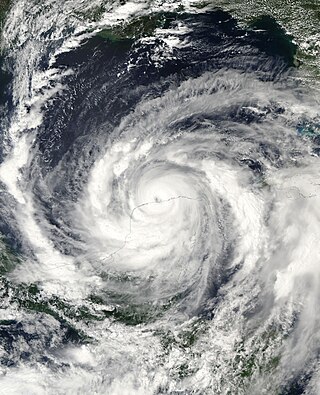
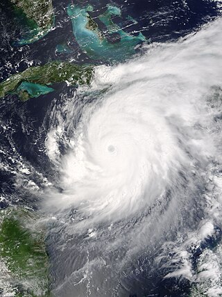
    Hurricane Michelle was the fifth costliest tropical cyclone in Cuban history and the strongest hurricane of the 2001 Atlantic hurricane season. The thirteenth named storm and seventh hurricane that year, Michelle developed from a tropical wave that had traversed into the western Caribbean Sea on October 29; the wave had initially moved off the coast of Africa 13 days prior. In its early developmental stages, the depression meandered over Nicaragua, later paralleling the Mosquito Coast before intensifying into tropical storm intensity on November 1; Michelle was upgraded to hurricane strength the following day. Shortly after, rapid intensification ensued within favorable conditions, with the storm's central barometric pressure dropping 51 mbar in 29 hours. After a slight fluctuation in strength, Michelle reached its peak intensity as a Category 4 hurricane with winds of 140 mph (230 km/h) and a minimum pressure of 933 mbar. This tied Michelle with 1999's Lenny as the fourth most powerful November hurricane on record in the Atlantic Basin, behind only the 1932 Cuba hurricane and 2020 Hurricanes Iota and Eta. At roughly the same time, the hurricane began to accelerate northeastward; this brought the intense hurricane to a Cuban landfall within the Bay of Pigs later that day. Crossing over the island, Michelle was weakened significantly, and was only a Category 1 hurricane upon reentry into the Atlantic Ocean. The hurricane later transitioned into an extratropical cyclone over The Bahamas on November 5, before being absorbed by a cold front the following day.

    <span class="mw-page-title-main">1979 Atlantic hurricane season</span> Hurricane season in the Atlantic Ocean

    The 1979 Atlantic hurricane season was the first Atlantic hurricane season to include both male and female names on its list of tropical cyclone names. The season officially began on June 1, and lasted until November 30. These dates conventionally delimit the period of each year when most tropical cyclones form in the Atlantic basin. It was slightly below average, with nine systems reaching tropical storm intensity. The first system, an unnumbered tropical depression, developed north of Puerto Rico on June 9. Two days later, Tropical Depression One formed and produced severe flooding in Jamaica, with 40 deaths and about $27 million (1979 USD) in damage. Tropical Storm Ana caused minimal impact in the Lesser Antilles. Hurricane Bob spawned tornadoes and produced minor wind damage along the Gulf Coast of the United States, primarily in Louisiana, while the remnants caused flooding, especially in Indiana. Tropical Storm Claudette caused extensive flooding in Texas due to torrential rainfall, resulting in two deaths and about $750 million in damage.

    <span class="mw-page-title-main">1985 Atlantic hurricane season</span> Hurricane season in the North Atlantic Ocean

    The 1985 Atlantic hurricane season had six United States landfalling hurricanes, tied with 1886 and 2020 for the highest number on record. The season officially began on June 1 and lasted until November 30. It was an average season, with 11 named storms developing. This was partially attributed to a La Niña – a meteorological phenomenon that produces favorable conditions across the Atlantic basin, such as lower wind shear and higher sea surface temperatures. The first storm, Ana, developed on July 15 near Bermuda and caused minor effects in Canada while transitioning into an extratropical cyclone. Three other tropical cyclones – Claudette, Henri, and Isabel – did not significantly affect land. Claudette developed offshore of the Southeastern United States and brushed Bermuda and the Azores. Henri and Isabel were dissipating as they approached land. However, the precursor of the latter caused a severe flood in Puerto Rico that killed 180 people. Additionally, Tropical Storm Fabian and three tropical depressions did not have any known impact on land.

    <span class="mw-page-title-main">Hurricane Isidore</span> Category 3 Atlantic hurricane in 2002

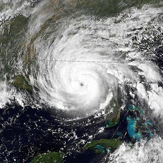
    Hurricane Isidore was a powerful tropical cyclone that caused widespread flooding and heavy damage across Mexico, Cuba, and the United States in September 2002. The ninth named storm and the second hurricane in the 2002 Atlantic hurricane season, and the fifth of eight named storms to occur in September of that year, Isidore peaked as a Category 3 hurricane, causing damage, as well as four fatalities in Jamaica, Cuba, Mexico, and the United States. Isidore is also noted for threatening to strike the northern Gulf Coast as a Category 4 hurricane, however, the storm struck the region as a moderately-strong tropical storm, due to a track change that brought the storm over the Yucatán Peninsula for over a day, which significantly weakened the cyclone in the process. The primary impact from the storm was the heavy rainfall, which fell across southeast Mexico, and also from the central United States Gulf coast into the Ohio Valley.

    <span class="mw-page-title-main">Hurricane Frederic</span> Category 4 Atlantic hurricane in 1979

    Hurricane Frederic was an intense and damaging tropical cyclone that carved a path of destruction from the Lesser Antilles to Quebec, in particular devastating areas of the United States Gulf Coast. Though only five were killed directly, the US$1.77 billion in damage accrued by Frederic made it the Atlantic basin's costliest tropical cyclone on record at the time. Prior to its final landfall, the threat that Frederic imposed on areas of the U.S. Gulf Coast triggered a mass exodus from the region larger than any other evacuation in the past. While the storm primarily impacted the U.S. states of Mississippi and Alabama, lesser effects were felt throughout the Greater and Lesser Antilles, as well as inland North America.

    <span class="mw-page-title-main">Hurricane Allen</span> Category 5 Atlantic hurricane in 1980

    Hurricane Allen was a rare and extremely powerful Cape Verde hurricane that affected the Caribbean, eastern and northern Mexico, and southern Texas in August 1980. The first named storm and second tropical cyclone of the 1980 Atlantic hurricane season, it was the fifth most intense Atlantic hurricane on record in terms of barometric pressure, behind Hurricane Rita, the 1935 Labor Day hurricane, Hurricane Gilbert and Hurricane Wilma. It was one of the few hurricanes to reach Category 5 status on the Saffir–Simpson Hurricane Scale on three occasions, and spent more time as a Category 5 than all but two other Atlantic hurricanes. Allen is the only hurricane in the recorded history of the Atlantic basin to achieve sustained winds of 190 mph, thus making it the strongest Atlantic hurricane by wind speed. Until Hurricane Patricia in 2015, these were also the highest sustained winds in the Western Hemisphere. Hurricane Allen was also the second strongest tropical cyclone to hit the Gulf of Mexico, with the strongest being Hurricane Rita.

    <span class="mw-page-title-main">2005 Atlantic hurricane season</span> Hurricane season in the Atlantic Ocean

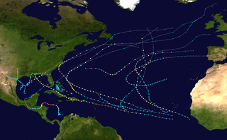
    The 2005 Atlantic hurricane season was the most active year on record until surpassed by 2020. It featured 28 tropical or subtropical storms. The United States National Hurricane Center named 27 storms, exhausting the annual pre-designated list, requiring the use of six Greek letter names, and adding an additional unnamed storm during a post-season re-analysis. A record 15 storms attained hurricane status, with maximum sustained winds of at least 74 miles per hour (119 km/h). Of those, a record seven became major hurricanes, rated Category 3 or higher on the Saffir–Simpson scale. Four storms of this season became Category 5 hurricanes, the highest ranking.

    <span class="mw-page-title-main">1915 Atlantic hurricane season</span> Hurricane season in the Atlantic Ocean

    The 1915 Atlantic hurricane season was an active Atlantic hurricane season in which six tropical storms developed. The first storm, which remained a tropical depression, appeared on April 29 near the Bahamas, while the final system, also a tropical depression, was absorbed by an extratropical cyclone well south of Newfoundland on October 22. Of the six tropical storms, five intensified into a hurricane, of which three further strengthened into a major hurricane. Four of the hurricanes made landfall in the United States. The early 20th century lacked modern forecasting and documentation, and thus, the hurricane database from these years may be incomplete.

    <span class="mw-page-title-main">Hurricane Dennis</span> Category 4 Atlantic hurricane in 2005

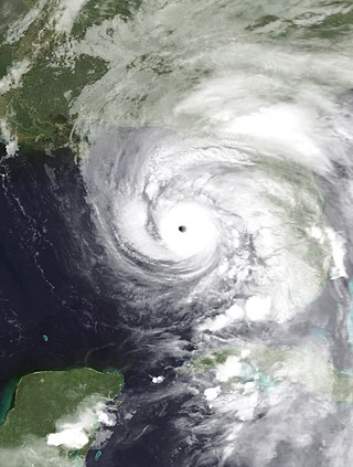
    Hurricane Dennis was an early-forming major hurricane in the Caribbean and Gulf of Mexico during the record-breaking 2005 Atlantic hurricane season. Dennis was the fourth named storm, second hurricane, and first major hurricane of the season. Forming in July, the hurricane became the strongest Atlantic hurricane ever to form before August at the time, a title it held for only six days before being surpassed by Hurricane Emily. It also became the second wettest tropical cyclone in the state of Kentucky only behind the 1960 Texas tropical storm.

    <span class="mw-page-title-main">Hurricane Emily (2005)</span> Category 5 Atlantic hurricane in 2005

    Hurricane Emily was a powerful early season Cape Verde hurricane that caused significant damage across the Caribbean to Mexico. It was also the earliest-forming Category 5 Atlantic hurricane on record in a season and the most intense to form before August. At the time, Emily was the earliest-forming fifth named storm in the Atlantic on record; this record has since been surpassed by 2020's Tropical Storm Edouard, and again the following year by 2021's Hurricane Elsa. After forming on July 10, 2005, the storm moved through the central Atlantic Ocean before passing through the Windward Islands on July 14. Tracking generally towards the west-northwest, the storm gradually intensified as it traversed the Caribbean, peaking as a Category 5 hurricane on July 16, marking the earliest date for a storm to do so during the course of a given year. The system subsequently made landfall in the Yucatán Peninsula as a Category 4. Quickly crossing the peninsula, Emily emerged into the Gulf of Mexico and reorganized. On July 20, the storm struck Tamaulipas as a major hurricane and rapidly dissipated within 24 hours. The storm caused significant damage along its path, with up to $1.01 billion in damages recorded, primarily in Mexico. 5 people died in each of Jamaica, Haiti, and Mexico; 2 people died elsewhere, for a total of 17 fatalities.

    <span class="mw-page-title-main">Meteorological history of Hurricane Ivan</span>

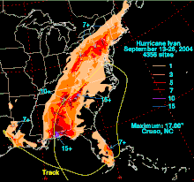
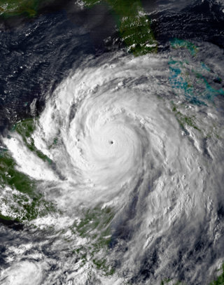
    The meteorological history of Hurricane Ivan, the longest tracked tropical cyclone of the 2004 Atlantic hurricane season, lasted from late August through late September. The hurricane developed from a tropical wave that moved off the coast of Africa on August 31. Tracking westward due to a ridge, favorable conditions allowed it to develop into Tropical Depression Nine on September 2 in the deep tropical Atlantic Ocean. The cyclone gradually intensified until September 5, when it underwent rapid deepening and reached Category 4 status on the Saffir-Simpson Hurricane Scale; at the time Ivan was the southernmost major North Atlantic hurricane on record.

    <span class="mw-page-title-main">Effects of Hurricane Ivan in the Greater Antilles</span>

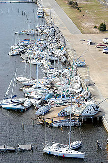
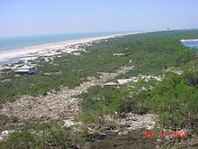
    From September 8 to 14, 2004, Hurricane Ivan moved through the Caribbean Sea, affecting all of the Greater Antilles. Reaching peak winds of 165 mph (266 km/h), Ivan attained Category 5 strength on the Saffir-Simpson Hurricane Scale, the strongest possible category, on three times in the Caribbean. It first lashed the southern coasts of Puerto Rico and Hispaniola with high waves, killing five people in the Dominican Republic and Haiti; in the latter country, two others drowned due to storm flooding. The effects in Jamaica were among the worst from a tropical cyclone in the island's recorded history. The storm caused severe damage which left 18,000 people homeless. An estimated 17 people on the island were killed by Ivan.

    <span class="mw-page-title-main">Hurricane Zeta</span> Category 3 Atlantic hurricane in 2020

    Hurricane Zeta was a late-season major hurricane in 2020 that made landfall on the Yucatán Peninsula and then in southeastern Louisiana, the latest on record to do so at such strength in the United States. Zeta was the record-tying sixth hurricane of the year to make landfall in the United States. The twenty-seventh named storm, twelfth hurricane and fifth major hurricane of the extremely active 2020 Atlantic hurricane season, Zeta formed from a broad area of low pressure that formed in the western Caribbean Sea on October 19. After battling wind shear, the quasi-stationary low organized into Tropical Depression Twenty-Eight on October 24. The system strengthened into Tropical Storm Zeta early on October 25 before becoming a hurricane the next day as it began to move northwestward. Hurricane Zeta made landfall on the Yucatán Peninsula late on October 26 and weakened while inland to a tropical storm, before moving off the northern coast of the peninsula on October 27. After weakening due to dry air entrainment, Zeta reorganized and became a hurricane again, and eventually a Category 2 hurricane, as it turned northeastward approaching the United States Gulf Coast on October 28. It continued to strengthen until it reached its peak intensity as a major Category 3 hurricane with 115-mile-per-hour (185 km/h) sustained winds and a minimum pressure of 970 mbar (28.64 inHg) as it made landfall at Cocodrie, Louisiana, that evening. Zeta continued on through Mississippi and parts of Alabama with hurricane-force winds. Zeta gradually weakened as it accelerated northeastward, and became post-tropical on October 29, as it moved through central Virginia, dissipating shortly afterwards off the coast of New Jersey. After bringing accumulating snow to parts of New England, the extratropical low-pressure system carrying Zeta's remnant energy impacted the United Kingdom on November 1 and 2.

    References

    1. 1 2 3 4 5 6 7 8 9 10 11 12 13 14 15 16 17 18 19 20 21 22 23 24 25 Stewart, Stacey (May 22, 2005). "Hurricane Ivan Tropical Cyclone Report" (PDF). National Hurricane Center . Retrieved August 20, 2010.
    2. Pasch, Richard (September 5, 2004). "Hurricane Ivan Discussion Number 14". National Hurricane Center. Retrieved August 20, 2010.
    3. Pasch, Richard (September 6, 2004). "Hurricane Ivan Advisory Number 18". National Hurricane Center. Retrieved September 7, 2010.
    4. Hurricane Ivan prompts rogue wave rethink, The Register , 5 August 2005
    5. "NRL Measures Record Wave During Hurricane Ivan - U.S. Naval Research Laboratory". nrl.navy.mil. February 17, 2017. Archived from the original on November 1, 2017. Retrieved March 26, 2018.
    6. Barringer, Felicity; Revkin, Andrew (September 17, 2004). Hurricane Ivan: The overview; Hurricane's Fury Kills 23 Along Gulf. The New York Times (Report). Retrieved September 7, 2010.
    7. Machos, G. Hurricane Ivan Roars through the Caribbean and United States Gulf Coast (Report). Hurricaneville. Archived from the original on February 23, 2009. Retrieved September 7, 2010.
    8. Avila, Lixion (September 22, 2004). "Tropical Depression Ivan Special Discussion Number 67". National Hurricane Center. Retrieved September 7, 2010.
    9. Halbach (2004). "Public Advisory Number 77 for Remnant Low of Ivan". Hydrometeorological Prediction Center. Retrieved October 20, 2007.[ dead link ]
    10. Wallace (2004). "September 25 Tropical Weather Discussion". National Hurricane Center. Retrieved October 20, 2007.[ permanent dead link ]
    11. MT (2004). "September 25 Tropical Weather Discussion (2)". National Hurricane Center. Retrieved October 20, 2007.[ permanent dead link ]
    12. Masters, Jeff; Hensen, Bob (September 29, 2021). "Hurricane Sam still a Cat 4; Tropical Depression 20 forms off coast of Africa". New Haven, Connecticut: Yale Climate Connections. Retrieved September 29, 2021.
    13. 1 2 "Easy to Read HURDAT". National Oceanic and Atmospheric Administration. 2009. Retrieved September 7, 2010.
    14. Stewart, Stacy R (April 3, 2017). Tropical Cyclone Report: Hurricane Matthew 2016 (PDF) (Technical report). United States National Hurricane Center. p. 11. Retrieved April 4, 2017.
    15. Crouch, Jake (July 31, 2009). "State of the Climate Hurricanes & Tropical Storms September 2004". National Climatic Data Center . Retrieved August 24, 2010.
    16. Dolce, Christ (2019). "The Five Atlantic Hurricanes That Produced the Most Tornadoes". The Weather Channel. Retrieved February 18, 2021.
    17. Chow, Daphne (2019). "Hurricane Ivan; 15 astounding facts, 15 years later". loopcayman.com. Retrieved February 18, 2021.
    18. Wang, David (August 5, 2005). "NRL Measures Record Wave During Hurricane Ivan". Naval Research Laboratory. Archived from the original on June 9, 2011. Retrieved August 24, 2010.
    19. 1 2 "Hurricane Ivan kills at least 14 in Caribbean". reliefweb. Agence France-Presse. 2004. Retrieved November 22, 2017.
    20. "Ivan leaves at least 12 dead in Grenada". Associated Press. 2004. Archived from the original on October 11, 2004. Retrieved November 23, 2007.
    21. "500,000 to evacuate, Many refuse to leave". Jamaica Observer. 2004. Archived from the original on June 6, 2007. Retrieved February 5, 2008.
    22. "Hurricane Ivan Pounds Jamaica". Fox News. September 11, 2004. Retrieved February 5, 2008.
    23. "Storm Weary Florida Braces for Hurricane Ivan". Environment News Service. 2004. Retrieved February 5, 2008.
    24. Natural Hazards Observer (November 2004). What if Hurricane Ivan Had Not Missed New Orleans? Archived July 15, 2007, at the Wayback Machine Retrieved on February 3, 2008.
    25. USA Today. Direct hit by Ivan in New Orleans could mean a modern Atlantis. Retrieved on September 14, 2004.
    26. "Evacuation, coast could feel force of storm for as long as 31 hours". Sun Herald. September 15, 2004.
    27. "Shelters on the Gulf Coast fill up as Dennis strengthens". USA Today. July 10, 2005.
    28. "Fla. Keys evacuate after Ivan pummels Caribbean, kills 1". USA Today. September 7, 2004.
    29. Kevin McDonough (February 15, 2006). "Animals saved from storm on 'Zoo'". The Spokesman Review.
    30. 1 2 3 4 5 6 7 8 "Twenty-seventh Session, RA IV Hurricane Committee: Final Report" (PDF). World Meteorological Organization. 2005. Archived from the original (PDF) on October 25, 2007. Retrieved April 27, 2006.
    31. Caribbean Update (January 1, 2005). "Ivan cost US$3.5 billion". The Gale Group. Retrieved May 17, 2009.
    32. 1 2 Macro Socio-Economic Assessment of the Damage and Losses Caused by Hurricane Paloma (PDF) (Report). United Nations Economic Commission for Latin America and the Caribbean. April 2009. p. vii. Retrieved May 20, 2015.
    33. 1 2 3 "Caribbean: Hurricane Ivan Information Bulletin" (PDF). International Federation of Red Cross and Red Crescent Societies. 2004. Retrieved November 23, 2007.
    34. Costliest U.S. tropical cyclones tables update (PDF) (Report). United States National Hurricane Centerf. January 12, 2018. Archived from the original on January 27, 2018. Retrieved January 12, 2018.
    35. CNN. Ivan's stormy trek floods Southeast. Retrieved on September 16, 2004.
    36. Video of the tornado. Archived from the original on April 17, 2005. Retrieved April 17, 2005.
    37. 1 2 3 Wilson, John (2005). "Initial environment examination" (PDF). USAID. p. 2. Archived from the original (PDF) on February 10, 2012. Retrieved December 24, 2020.
    38. "Cuba mostly spared Ivan's wrath". MSNBC. Associated Press. September 15, 2004. Retrieved November 3, 2011.
    39. Direct Relief International (2006). "Grenada: Direct Relief's programme activities update Jun 2006". ReliefWeb. Retrieved November 20, 2007.
    40. Eric Green (September 16, 2004). "World Bank Join U.S. in Aiding Caribbean Hurricane Victims; Aid will go to nations hit by Hurricanes Frances, Ivan". Washington File.
    41. "Twenty-Seventh Session RA IV Hurricane Committee" (PDF). World Meteorological Organization. 2005. Archived from the original (PDF) on September 27, 2012. Retrieved November 3, 2011.
    42. "Hurricanes and tropical storms in the Netherlands Antilles and Aruba" (PDF). Meteorological Service of the Netherlands Antilles and Aruba. p. 19. Archived from the original (PDF) on April 2, 2012. Retrieved November 6, 2011.
    43. "Orkaan Ivan gedraagt zich op Curaçao als gewone storm". Trouw. De Persgroep Nederland. September 10, 2004. Retrieved November 23, 2011.
    44. United States Department of State. "U.S. Gives Jamaica ,50,000 for School Equipment and Supplies". Archived May 27, 2005, at the Wayback Machine Retrieved on February 16, 2005.
    45. Caribbean Disaster Emergency Response Agency. News Conference Report: Tourism impact on the Caribbean by Hurricanes Frances, Ivan, Jeanne. Archived May 28, 2005, at the Wayback Machine Retrieved on September 30, 2004.
    46. "Letter from the Cayman Islands Government Office in the United Kingdom, 8 October 2004". Parliament of the United Kingdom. October 8, 2004. Retrieved October 11, 2016.
    47. Kitty Bean Yancey (September 17, 2004). "Grenada, Grand Cayman, Grand Bahama feel the pain". USA Today.
    48. Mark Schleifstein. "Taylor Energy oil platform, destroyed in 2004 during Hurricane Ivan, is still leaking in Gulf". The Times-Picayune.
    49. "Site 23051: Chronology". December 3, 2018.
    50. Romo, Vanessa (May 16, 2019), Oil Spill Seeping Into Gulf Of Mexico Contained After 14 Years, Coast Guard Says, NPR, retrieved May 17, 2019
    51. Costliest U.S. tropical cyclones tables update (PDF) (Report). U.S. National Hurricane Center. January 12, 2018. Archived (PDF) from the original on January 27, 2018. Retrieved January 12, 2018.
    52. 1 2 3 Hayes, Franklin (September 21, 2006). "Elderly Left Homeless by FEMA Deadline". Gulf Breeze News. Archived from the original on September 27, 2011. Retrieved November 3, 2011.
    53. "Hurricane Ivan - September 16, 2004". National Weather Service Mobile, Alabama. Retrieved August 19, 2019.
    54. "Hurricane Ivan...September 2004". National Weather Service Forecast Office Birmingham, AL, National Oceanic and Atmospheric Administration. March 22, 2006. Archived from the original on February 17, 2009. Retrieved November 3, 2011.
    55. Timothy P. Marshall. Hurricane Ivan Damage Survey. Retrieved on February 1, 2008.
    56. "Remembering Hurricane Ivan 14 years later". September 16, 2018.
    57. Feuer, Alan (September 19, 2004). "Hurricane Ivan's Last Gasp Leaves New York Region Soaked". The New York Times.
    58. Dnet Web Services. Peeks Creek Photos. Archived March 4, 2007, at the Wayback Machine Retrieved on February 1, 2008.
    59. North Carolina Geological Survey. Landslides. Archived May 16, 2007, at the Wayback Machine Retrieved on February 1, 2008.
    60. The Washington Times. Maryland women die in Ivan's wake. Retrieved September 19, 2004.
    61. Virginia Department of Emergency Management. Virginia's Weather History: Virginia Tornadoes. Archived May 2, 2008, at the Wayback Machine Retrieved on February 3, 2008.
    62. National Weather Service Forecast Office, Pittsburgh, PA. NWS Pittsburgh Hourly Climate Data Archive, August, 2004. Retrieved on February 1, 2008.
    63. Pennsylvania Emergency Management Agency. Ivan Flooding Situation Reports: September 28, 2004, Situation Report #15. Retrieved on February 1, 2008. [ dead link ]
    64. "Hurricane Severity Index" (PDF). Archived (PDF) from the original on August 28, 2020. Retrieved September 11, 2019.
    65. Canadian Hurricane Centre (2004). "2004 Tropical Cyclone Season Summary". Archived from the original on May 1, 2006. Retrieved June 23, 2006.
    66. Ministry of Finance; Government of Grenada (February 22, 2005). "IMF statement on Grenada". Archived from the original on August 18, 2007. Retrieved November 3, 2011.
    67. Green, Eric (February 24, 2005). "Grenada Making Comeback from Hurricane Ivan". United States Department of State. Archived from the original on November 22, 2006. Retrieved November 3, 2011.
    68. "USAID/Jamaica – CAR Hurricane Ivan Recovery Program in Jamaica" (PDF). United States Agency for International Development. June 30, 2005. Retrieved November 2, 2011.
    69. Peters, Gerhard; Woolley, John (September 27, 2004). "Fact Sheet: Responding to Hurricanes Ivan and Jeanne". The American Presidency Project. Retrieved November 3, 2011.
    70. United States Department of Homeland Security (March 10, 2005). "Alabama Disaster Assistance Approaches $735 Million Dollars". Federal Emergency Management Agency. Archived from the original on June 6, 2010. Retrieved November 2, 2011.
    71. Florida Department of Agriculture and Consumer Services. Soybean Rust Confirmed In Florida. Archived March 7, 2005, at the Wayback Machine Retrieved on November 17, 2004.
    72. United States Department of Homeland Security (September 9, 2005). "Hurricane Ivan Recovery In The Panhandle Adds Up To $1.4 Billion". Federal Emergency Management Agency. Archived from the original on February 11, 2012. Retrieved November 2, 2011.
    73. United States Department of Homeland Security (October 5, 2004). "More Than $4 Million In Disaster Aid". Federal Emergency Management Agency. Archived from the original on September 17, 2011. Retrieved November 2, 2011.
    74. United States Department of Homeland Security (November 9, 2004). "Disaster Application Deadline Approaches". Federal Emergency Management Agency. Archived from the original on January 6, 2012. Retrieved November 3, 2011.
    75. "4 hurricanes in 6 weeks? It happened to one state in 2004". Washington, D.C.: NOAA. August 26, 2019. Retrieved April 11, 2024.
    76. "Retired Hurricane Names Since 1954". National Hurricane Center. 2009. Archived from the original on June 28, 2011. Retrieved September 8, 2010.
    77. National Hurricane Operations Plan (PDF) (Report). Washington, D.C.: NOAA Office of the Federal Coordinator for Meteorological Services and Supporting Research. May 2010. p. 3-7. Retrieved April 11, 2024.
    78. "Worldwide Tropical Cyclone Names". National Hurricane Center. 2010. Archived from the original on September 2, 2010. Retrieved September 8, 2010.
    79. Simons, Paul; Hamilton, Alan (June 15, 2005). "The ten-storey Mexican wave". The Times. London. Retrieved May 4, 2010.