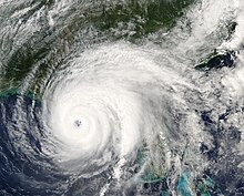
Hurricane Georges was a powerful and long-lived Cape Verde Category 4 hurricane which caused severe destruction as it traversed the Caribbean and Gulf of Mexico in September 1998,making seven landfalls along its path. Georges was the seventh tropical storm,fourth hurricane,and second major hurricane of the 1998 Atlantic hurricane season. It became the most destructive storm of the season,the costliest Atlantic hurricane since Hurricane Andrew in 1992 and remained the costliest until Hurricane Charley in 2004,and the deadliest since Hurricane Gordon in 1994. Georges killed 604 people,mainly on the island of Hispaniola,caused extensive damage resulting at just under $10 billion in damages and leaving nearly 500,000 people homeless in St. Kitts and Nevis,Puerto Rico,Hispaniola and Cuba.

Hurricane Ivan was a large,long-lived,Cape Verde hurricane that caused widespread damage in the Caribbean and United States. The cyclone was the ninth named storm,the sixth hurricane and the fourth major hurricane of the active 2004 Atlantic hurricane season.
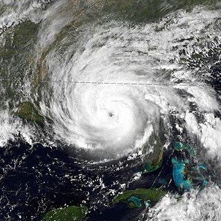
Hurricane Frederic was an intense and damaging tropical cyclone that carved a path of destruction from the Lesser Antilles to Quebec,in particular devastating areas of the United States Gulf Coast. Though only five were killed directly,the US$1.77 billion in damage accrued by Frederic made it the Atlantic basin's costliest tropical cyclone on record at the time. Prior to its final landfall,the threat that Frederic imposed on areas of the U.S. Gulf Coast triggered a mass exodus from the region larger than any other evacuation in the past. While the storm primarily impacted the U.S. states of Mississippi and Alabama,lesser effects were felt throughout the Greater and Lesser Antilles,as well as inland North America.
Hurricane Dennis was an early-forming major hurricane in the Caribbean and Gulf of Mexico during the record-breaking 2005 Atlantic hurricane season. Dennis was the fourth named storm,second hurricane,and first major hurricane of the season. Forming in July,the hurricane became the strongest Atlantic hurricane ever to form before August at the time,a title it held for only six days before being surpassed by Hurricane Emily. It also became the second wettest tropical cyclone in the state of Kentucky only behind the 1960 Texas tropical storm.

Hurricane Erin was the first hurricane to strike the contiguous United States since Hurricane Andrew in 1992. The fifth tropical cyclone,fifth named storm,and second hurricane of the unusually active 1995 Atlantic hurricane season,Erin developed from a tropical wave near the southeastern Bahamas on July 31. Moving northwestward,the cyclone intensified into a Category 1 hurricane on the Saffir–Simpson scale near Rum Cay about 24 hours later. After a brief jog to the north-northwest on August 1,Erin began moving to the west-northwest. The cyclone then moved over the northwestern Bahamas,including the Abaco Islands and Grand Bahama. Early on August 2,Erin made landfall near Vero Beach,Florida,with winds of 85 mph (137 km/h). The hurricane weakened while crossing the Florida peninsula and fell to tropical storm intensity before emerging into the Gulf of Mexico later that day.

Hurricane Danny was the only hurricane to make landfall in the United States during the 1997 Atlantic hurricane season,and the second hurricane and fourth tropical storm of the season. The system became the earliest-formed fifth tropical or subtropical storm of the Atlantic season in history when it attained tropical storm strength on July 17,and held that record until the 2005 Atlantic hurricane season when Tropical Storm Emily broke that record by several days. Like the previous four tropical or subtropical cyclones of the season,Danny had a non-tropical origin,after a trough spawned convection that entered the warm waters of the Gulf of Mexico. Danny was guided northeast through the Gulf of Mexico by two high pressure areas,a rare occurrence in the middle of July. After making landfall on the Gulf Coast,Danny tracked across the southeastern United States and ultimately affected parts of New England with rain and wind.

Hurricane Kate was the final in a series of tropical cyclones to impact the United States during 1985. It was the eleventh named storm,seventh hurricane,and third major hurricane of the 1985 Atlantic hurricane season,Kate originated from the interaction of an upper-level trough and tropical wave northeast of Puerto Rico on November 15. Though the system tracked erratically during the first hours of its existence,the intensification of a region of high pressure to the cyclone's north caused Kate to turn westward. A favorable atmospheric pattern allowed the newly developed system to intensify to hurricane intensity on November 16,and further to Category 2 intensity three days later.
Tropical Storm Arlene was an unusually large and early-forming tropical storm,being the first of twenty-eight different storms during the 2005 Atlantic hurricane season,which would become the second most active season on record. Tropical Storm Arlene formed near Honduras on June 8 and moved northwards. It crossed western Cuba on June 10 and strengthened to just under hurricane strength before making its final landfall on the Florida Panhandle the next day. The storm weakened as it continued to move north over the United States,becoming extratropical on June 13. Arlene was responsible for two deaths and minor damage.

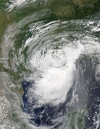
The Effects of Hurricane Dennis in Alabama included $127 million (2005 USD) in damage and three injuries. Dennis made landfall on the Florida Panhandle as a Category 3 hurricane on the Saffir-Simpson scale on July 10,2005,before tracking over Alabama as a minimal hurricane. In preparation for the storm,about 500,000 people were given evacuation orders,and the Red Cross opened 87 shelters. As a result,all southbound lanes of Interstate 65 from Mobile to Montgomery were closed.

Hurricane Baker was a Category 2 hurricane that affected the Leeward Islands,Greater Antilles,and the Gulf Coast of the United States. The tropical cyclone was the second tropical storm and second hurricane of the 1950 Atlantic hurricane season. Originating as a tropical depression east of the Windward Islands on August 18,Baker became a tropical storm on August 19,and further intensified into a hurricane on August 21. It attained an initial peak intensity with maximum sustained winds of 100 mph (160 km/h) on August 22 before weakening to a tropical storm as it made landfall on the island of Antigua. Baker weakened to a tropical depression late on August 23 while southwest of Puerto Rico. By the following morning,it had restrengthened into a tropical storm,though a landfall in Cuba caused it to weaken once again. Entering the Gulf of Mexico,Baker began to strengthen once more,regaining hurricane strength on August 29 and reaching its peak intensity with maximum sustained winds of 105 mph (169 km/h) early the following day. The cyclone weakened before making its final landfall in the United States near Gulf Shores,Alabama,with winds of 85 mph (137 km/h). Hurricane Baker produced extensive damage in the Lesser Antilles and Cuba,but impacts were minimal in the United States.

Hurricane Isaac was a deadly and destructive tropical cyclone that came ashore in the U.S. state of Louisiana during August 2012. The ninth named storm and fourth hurricane of the annual hurricane season,Isaac originated from a tropical wave that moved off the west coast of Africa on August 16. Tracking generally west,a broad area of low pressure developed along the wave axis the next day,and the disturbance developed into a tropical depression early on August 21 while several hundred miles east of the Lesser Antilles. The system intensified into a tropical storm shortly thereafter,but high wind shear initially prevented much change in strength.
Hurricane Barry was an asymmetrical Category 1 hurricane that was the wettest tropical cyclone on record in Arkansas and the fourth-wettest in Louisiana. The second tropical or subtropical storm and first hurricane of the 2019 Atlantic hurricane season,Barry originated as a mesoscale convective vortex over southwestern Kansas on July 2. The system eventually emerged into the Gulf of Mexico from the Florida Panhandle on July 10,whereupon the National Hurricane Center (NHC) designated it as a potential tropical cyclone. Early on July 11,the system developed into a tropical depression,and strengthened into a tropical storm later that day. Dry air and wind shear caused most of the convection,or thunderstorms,to be displaced south of the center. Nevertheless,Barry gradually intensified. On July 13,Barry attained its peak intensity as Category 1 hurricane with 1-minute sustained winds of 75 mph (120 km/h) and a minimum central pressure of 993 millibars (29.3 inHg). At 15:00 UTC,Barry made its first landfall at Marsh Island,and another landfall in Intracoastal City,Louisiana,both times as a Category 1 hurricane. Barry quickly weakened after landfall,falling to tropical depression status on July 15. The storm finally degenerated into a remnant low over northern Arkansas on the same day,subsequently opening up into a trough on July 16. The storm's remnants persisted for another few days,while continuing its eastward motion,before being absorbed into another frontal storm to the south of Nova Scotia on July 19.

Hurricane Dorian was an extremely powerful and catastrophic Category 5 Atlantic hurricane,which became the most intense tropical cyclone on record to strike the Bahamas,and is tied with the 1935 Labor Day hurricane for the strongest landfall in the Atlantic basin in terms of maximum sustained winds. The 2019 cyclone is regarded as the worst natural disaster in the Bahamas' recorded history. With winds peaking at 185 mph (295 km/h),it was also one of the most powerful hurricanes recorded in the Atlantic Ocean in terms of 1-minute sustained winds,and the strongest since Wilma in 2005. Dorian was the fourth named storm,second hurricane,the first major hurricane,and the first Category 5 hurricane of the 2019 Atlantic hurricane season. Dorian struck the Abaco Islands on September 1 with maximum sustained winds of 185 mph (295 km/h),tying with the 1935 Labor Day hurricane for the highest wind speeds of an Atlantic hurricane ever recorded at landfall. Dorian went on to strike Grand Bahama at similar intensity,stalling just north of the territory with unrelenting winds for at least 24 hours. The resultant damage to these islands was catastrophic;most structures were flattened or swept to sea,and at least 70,000 people were left homeless. After it ravaged through the Bahamas,Dorian proceeded along the coasts of the Southeastern United States and Atlantic Canada,leaving behind considerable damage and economic losses in those regions.

Hurricane Laura was a deadly and destructive Category 4 hurricane that is tied with the 1856 Last Island hurricane and 2021's Hurricane Ida as the strongest hurricane on record to make landfall in the U.S. state of Louisiana,as measured by maximum sustained winds. The twelfth named storm,fourth hurricane,and first major hurricane of the record-breaking 2020 Atlantic hurricane season,Laura originated from a large tropical wave that moved off the West African coast on August 16 and became a tropical depression on August 20. Laura intensified into a tropical storm a day later,becoming the earliest twelfth named storm on record in the North Atlantic basin,forming eight days earlier than 1995's Hurricane Luis.

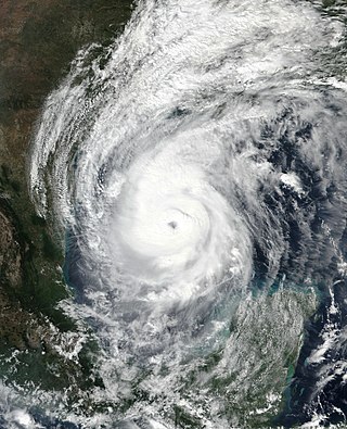
Hurricane Sally was a destructive and slow-moving Atlantic hurricane that was the first hurricane to make landfall in the U.S. state of Alabama since Ivan in 2004,coincidentally on the same date in the same place. The eighteenth named storm and seventh hurricane of the extremely active 2020 Atlantic hurricane season,Sally developed from an area of disturbed weather which was first monitored over the Bahamas on September 10. The system grew a broad area of low-pressure on September 11,and was designated as a tropical depression late that day. Early the next day,the depression made landfall at Key Biscayne and subsequently strengthened into Tropical Storm Sally that afternoon. Moderate northwesterly shear prevented significant intensification for the first two days,but convection continued to grow towards the center and Sally slowly intensified. On September 14,a center reformation into the center of the convection occurred,and data from a hurricane hunter reconnaissance aircraft showed that Sally had rapidly intensified into a strong Category 1 hurricane. However,an increase in wind shear and upwelling of colder waters halted the intensification and Sally weakened slightly on September 15 before turning slowly northeastward. Despite this increase in wind shear,it unexpectedly re-intensified,reaching Category 2 status early on September 16 before making landfall at peak intensity at 09:45 UTC on September 16,near Gulf Shores,Alabama,with maximum sustained winds of 110 mph (180 km/h) and a minimum central pressure of 965 millibars (28.5 inHg). The storm rapidly weakened after landfall before transitioning into an extratropical low at 12:00 UTC the next day. Sally's remnants lasted for another day as they moved off the coast of the Southeastern United States before being absorbed into another extratropical storm on September 18.
Hurricane Delta was the record-tying fourth named storm of 2020 to make landfall in Louisiana,as well as the record-breaking tenth named storm to strike the United States in that year. The twenty-sixth tropical cyclone,twenty-fifth named storm,tenth hurricane,and third major hurricane of the record-breaking 2020 Atlantic hurricane season,Delta formed from a tropical wave which was first monitored by the National Hurricane Center (NHC) on October 1. Moving westward,the tropical wave began to quickly organize. A well-defined center of circulation formed with sufficiently organized deep convection on October 4,and was designated as Tropical Depression Twenty-six and soon thereafter,Tropical Storm Delta. Extremely rapid intensification ensued throughout October 5 into October 6,with Delta becoming a Category 4 hurricane within 28 hours of attaining tropical storm status. The rate of intensification was the fastest in the Atlantic basin since Hurricane Wilma in 2005. After peaking in intensity however,an unexpected increase in wind shear and dry air quickly weakened the small storm before it made landfall in Puerto Morelos,Mexico as a Category 2 hurricane with 105 mph (169 km/h) winds. It weakened some more over land before emerging into the Gulf of Mexico,where it was downgraded to a Category 1 hurricane. After that,it began to restrengthen,regaining Category 3 status late on October 8. It then turned northward and reached a secondary peak intensity of 953 mbar (28.14 inHg) and winds of 120 mph early on October 9. Delta then began to turn more north-northeastward into an area of cooler waters,higher wind shear,and dry air,causing it to weaken back to Category 2 status. Delta then made landfall at 23:00 UTC near Creole,Louisiana with winds of 100 mph (160 km/h) and a pressure of 970 mbar (29 inHg). The storm began to weaken more rapidly after landfall,becoming post-tropical just 22 hours later.

Hurricane Zeta was a late-season major hurricane in 2020 that made landfall on the Yucatán Peninsula and then in southeastern Louisiana,the latest on record to do so at such strength in the United States. Zeta was the record-tying sixth hurricane of the year to make landfall in the United States. The twenty-seventh named storm,twelfth hurricane and fifth major hurricane of the extremely active 2020 Atlantic hurricane season,Zeta formed from a broad area of low pressure that formed in the western Caribbean Sea on October 19. After battling wind shear,the quasi-stationary low organized into Tropical Depression Twenty-Eight on October 24. The system strengthened into Tropical Storm Zeta early on October 25 before becoming a hurricane the next day as it began to move northwestward. Hurricane Zeta made landfall on the Yucatán Peninsula late on October 26 and weakened while inland to a tropical storm,before moving off the northern coast of the peninsula on October 27. After weakening due to dry air entrainment,Zeta reorganized and became a hurricane again,and eventually a Category 2 hurricane,as it turned northeastward approaching the United States Gulf Coast on October 28. It continued to strengthen until it reached its peak intensity as a major Category 3 hurricane with 115-mile-per-hour (185 km/h) sustained winds and a minimum pressure of 970 mbar (28.64 inHg) as it made landfall at Cocodrie,Louisiana,that evening. Zeta continued on through Mississippi and parts of Alabama with hurricane-force winds. Zeta gradually weakened as it accelerated northeastward,and became post-tropical on October 29,as it moved through central Virginia,dissipating shortly afterwards off the coast of New Jersey. After bringing accumulating snow to parts of New England,the extratropical low-pressure system carrying Zeta's remnant energy impacted the United Kingdom on November 1 and 2.

The effects of Hurricane Katrina in Alabama were damaging and deadly. On August 29,Hurricane Katrina made two landfalls in Louisiana and Mississippi. Katrina caused many impacts due to its large wind field across the southeast,including places like Alabama.