Hurricane Lili

Last updated
Map key
  Tropical depression (≤38 mph, ≤62 km/h)
  Tropical storm (39–73 mph, 63–118 km/h)
  Category 1 (74–95 mph, 119–153 km/h)
  Category 2 (96–110 mph, 154–177 km/h)
  Category 3 (111–129 mph, 178–208 km/h)
  Category 4 (130–156 mph, 209–251 km/h)
  Category 5 (≥157 mph, ≥252 km/h)
  Unknown
Storm type
Disc Plain black.svg Tropical cyclone
Solid black.svg Subtropical cyclone
ArrowUp.svg Extratropical cyclone, remnant low, tropical disturbance, or monsoon depression

A tropical wave moved off the west coast of Africa on September 16. A low level center of circulation developed from a tropical disturbance spawned by this tropical wave midway between the African coast and the Caribbean on September 20. The next day, the system gained sufficient organization to become a tropical depression. [1] [5] The depression moved westward in excess of 20 mph (32 km/h), and reached tropical storm strength-becoming Tropical Storm Lili as it passed through the Windward Islands. [6] The cyclone continued to intensify as it moved west through the Caribbean Sea, reaching an initial peak strength of 70 mph (110 km/h) on the morning of September 24. [7] This was immediately followed by an abrupt weakening, and the storm's maximum sustained winds dropped to 40 mph (64 km/h) later that day. [8] The sudden weakening was attributed to strong southerly vertical shear. [9] The system degenerated into an open tropical wave the next morning, and remained in that state for nearly two days.

Hurricane Lili over the Gulf of Mexico seen from the International Space Station (ISS) on October 2 Hurricane Lili over the Gulf of Mexico from the ISS.jpg
Hurricane Lili over the Gulf of Mexico seen from the International Space Station (ISS) on October 2

Lili regenerated near Jamaica on the evening of September 26 and gradually turned more to the west-northwest while strengthening. [1] The system became a hurricane on September 30, just after passing through the Cayman Islands. [10] The storm continued on its course while continuing to intensify, and made landfall twice the next day, on the Isle of Youth and near Pinar del Río as a Category 2 hurricane. [11] Lili emerged over the Gulf of Mexico later that day, having lost little strength during its overland passage. [1] [12]

The system turned to the northwest and sped up, becoming a major hurricane on October 2 while 365 miles (587 km) south-southeast of New Orleans. [13] This intensification continued, aided by warm sea surface temperatures in the Gulf of Mexico and good outflow. [14] The system reached its peak strength of category 4 intensity, with winds of 145 mph (233 km/h), during that afternoon. [15]

This strength was not maintained for long. The storm began to quickly weaken in the early morning hours of October 3, [16] and this rapid weakening continued until the hurricane's final landfall near Intracoastal City, Louisiana, due to a combination of vertical wind shear, cool waters just offshore Louisiana, [17] and slowly encroaching dry air within its southwest quadrant. [18] By the time of landfall, maximum sustained winds had dropped to 90 mph (145 km/h). [19] The weakening was accompanied by a collapse of the inner eyewall before landfall. [1] The system continued inland, curving to the north-northeast, and dissipated when absorbed by an extratropical low near the Arkansas/Tennessee border on October 6. [1]

Preparations

National Hurricane Center track forecast of Lili from September 30 Lili2002sep30NHCforecast.GIF
National Hurricane Center track forecast of Lili from September 30

Tropical storm watches were issued in parts of the Lesser Antilles on September 22. These were upgraded to warnings the next afternoon, and all advisories were dropped late on September 23 once the storm had passed. [1] Over the next week, the islands of Hispaniola, Jamaica, Cuba, the Caymans, and the Yucatán Peninsula were all under advisories of some kind at different times. [1] Hurricane and tropical storm watches were issued for the Gulf Coast on October 1, and were upgraded to warnings the next morning. [1] They were discontinued after the storm moved past the following day. [20]

Strike probabilities associated with Lili while still out in the south-central Gulf of Mexico Lili2002strikeprobabilities.gif
Strike probabilities associated with Lili while still out in the south-central Gulf of Mexico

Preparations in most of the Lesser Antilles were minimal as the storm only hit as a tropical storm. Two hundred people evacuated their homes in advance of the storm on the islands of St. Vincent and Grenadine. [2] In Jamaica, all schools and universities were closed in advance of the storm, and 17 public shelters were opened on the island. [21]

Preparations were extensive in Cuba. Military officials at the Guantanamo Bay detention camp prepared for the possibility of evacuating their Al Qaeda and Taliban prisoners. [22] A total of 130,000 Cuban citizens, mainly in western portions of the island, evacuated their homes prior to the storm. [23]

Significant action was taken along the Gulf Coast as the threat the storm posed, predicted to come ashore at Category Four strength, became more urgent. Over a half million people evacuated their homes in Texas and Louisiana, including everyone in Iberia Parish. [24] A total of 200,000 people evacuated in Louisiana. [24] [25] At least 2,000 volunteers staffed 115 Red Cross shelters in Louisiana, Texas, Mississippi, and Alabama. [26] More than 20,000 people stayed in those shelters. [25] The Red Cross also sent over 160,000 meals to the area. [26] A total of 3,000 prison inmates in Texas were evacuated to safer inland locations. [24] The launch of Space Shuttle Atlantis was delayed for five days when the Kennedy Space Center was threatened by the storm, the first time a launch in Florida had been delayed because of weather in Houston. [27] Stores across the warning area were very busy in advance of the storm. In New Iberia, Louisiana, hardware stores ran out of stock, [28] and businesses in Lafayette, Louisiana reported similar shortages. [29]

Collegiate activities were also affected by the storm. Southern University canceled four days of classes because of Lili, [30] and 20 Texas A&M University Galveston, Texas students evacuated to the school's College Station location. [31] The University of South Alabama canceled two athletic events in advance of the storm. [32]

Impact

Hurricane Lili
Lili 2002-10-02 1645Z (cropped).jpg
Lili near peak intensity in the Gulf of Mexico on October 2
Death toll by area
State/countryDeaths
Saint Lucia 4
Jamaica 4
Haiti 4
Cuba 1
United States2
Total15
Hurricane Lili shortly after landfall in Louisiana on October 3 Lili 2002-10-03 1900Z.jpg
Hurricane Lili shortly after landfall in Louisiana on October 3

Hurricane Lili was both the second deadliest and the second most devastating hurricane of the 2002 Atlantic hurricane season (Isidore killed 22 people and damaged $1.28 billion worth of property). [33] A total of 13 people died in the Caribbean Islands, and 2 more were killed in the United States. [1] Severe damage to crops and livestock occurred through the Lesser Antilles, and damage to buildings and other infrastructure was reported in other Caribbean nations and the United States. [1]

Lesser Antilles

Lili affected the islands as a tropical storm. Winds in the area were generally below hurricane force, although some gusts exceeded 74 mph (119 km/h). [1] Rainfall of up to 4 inches (100 mm) caused deadly mudslides. [2] The winds, combined with poor construction, tore the roofs off numerous homes and businesses. The majority of the damage was dealt to primarily to the banana crop. [34]

St. Lucia lost at least 75 percent of its banana crop, and hundreds of homes were damaged by the strong winds. [2] Near total loss of electricity, water, and telephone services occurred, and utility systems were heavily damaged. [34] Four people were killed on the island, and total damage was estimated at $20 million (2002 USD) [1] [34]

Over 400 homes were damaged in Barbados, and nearly 50 trees were downed by the high gusts. Similar to in St. Lucia, there was significant damage to the nation's banana crop. [34] Extensive loss of electricity and telephone service also occurred. Damage totaled at nearly $200,000 (2002 USD).

Grenada also experienced moderate damage. A total of 14 homes' roofs were damaged, and one was completely destroyed. The island Medical Centre's roof was also damaged, and 12 landslides were reported. [34] There was also mild damage to infrastructure, particularly in St. Patrick's Parish; three bridges were damaged or destroyed, along with seven utility poles and a water main. The entire island was without power at some point, but it was quickly restored in the southern part of the island where damage to the poles themselves was less significant. [34]

St. Vincent and the Grenadines were heavily damaged, especially compared to other islands in the area. Several hundred homes and two schools were damaged, and the Rose Hall Police Station's roof was lost. [34] Still, the majority of damage was dealt to the agricultural industry. [34] In all, damage to the islands totaled $40 million (2002 USD). [34]

Haiti

Wettest tropical cyclones and their remnants in Haiti
Highest-known totals
PrecipitationStormLocationRef.
Rankmmin
11,447.857.00 Flora 1963 Miragoâne [35]
2654.825.78 Noel 2007 Camp Perrin [36]
3604.523.80 Matthew 2016 Anse-á-Veau [37]
4410.016.14 Lili 2002 Camp Perrin [38]
5323.012.72 Hanna 2008 Camp Perrin [39]
6273.010.75 Gustav 2008 Camp Perrin [40]
7168.06.614 Laura 2020 Port-Au-Prince [41]
865.02.56 Fox 1952 Ouanaminthe [42]

Lili passed offshore of Haiti as a weakening tropical storm. [1] The storm's major impact was extremely heavy rainfall, in excess of 16 inches (410 mm) near the settlement of Camp-Perrin, Haiti. [43] This caused the Ravine du Sud River to overflow, and submerge buildings in the town. Two people died in the mudslides these rains triggered, and two more drowned in the flooding around Camp-Perrin. [44] The floods also seriously damaged crops and infrastructure; over 1700 homes were damaged and 240 were destroyed. Haiti was affected dramatically and many towns and villages submerged into rivers exceeding their bankfull discharge [44]

Jamaica

Lili affected Jamaica as a strengthening tropical storm. Wind gusts in excess of 70 mph (110 km/h) and rainfall over 2 feet (0.61 m) resulted in damage to homes, crops, and utility systems. [1] [21]

Extremely heavy rainfall inundated the island. Cedar Valley recorded the most rainfall, with 23.1 inches (590 mm) measured. This led to prolific flooding that triggered mudslides across the island and killed four people. These floods decimated the island's sugar cane crop, one of the island's principal exports. [21] The resultant flooding caused widespread problems with the infrastructure of the island. All of the island's hospitals had flood damage, and three were also dealt structural damage by the strong winds. [45] The flooding caused latrines and other sewage sources to overflow into the intake sources for the water supply, leading to fear of disease. [45]

Cuba

Hurricane Lili over Cuba on October 1 Lili2002overcuba.jpg
Hurricane Lili over Cuba on October 1

Lili made landfall as a category two hurricane twice in Cuba, on the Isle of Youth and in the Pinar del Río Province, on October 1. Wind gusts up to 112 mph (180 km/h) and rainfall amounts reaching 6 inches (150 mm) in some places caused damage to homes, businesses and crops. One person was killed. [1] [46]

Damage to buildings and other infrastructure was significant. The most severely affected provinces were Pinar del Río and La Habana. A total of 48,000 homes were damaged, 16,000 of them lost their roofs. The province Sancti Spiritus was not affected as severely, as only 945 homes were damaged, with 500 losing their roofs. The provinces in Eastern Cuba, including Guantanamo, suffered similar damage. [47] Electricity outages for whole towns lasted weeks in parts of the western provinces. This led to loss of running water due to unpowered pumps, and deliveries of fresh water had to be made to remote villages. [46] The tobacco and rice crops were badly depleted, but it was difficult to differentiate how much damage was caused by Lili, since Isidore had struck the region just a week earlier. [46] [48]

Louisiana

Lili Storm Total Rainfall in the United States Lili2002rainfilledwhite.gif
Lili Storm Total Rainfall in the United States

Lili made landfall on the morning of October 3 near Intracoastal City, as a weakening category one hurricane. [1] Wind gusts reaching 120 mph (190 km/h), coupled with over 6 inches (150 mm) of rainfall and a storm surge of 12 feet (3.7 m) caused over $790 million (2002 USD) in damage to Louisiana. A total of 237,000 people lost power, and oil rigs offshore were shut down for up to a week. [49] Crops were badly affected, particularly the sugar cane, damage totaled nearly $175 million (2002 USD). No direct deaths were reported as early warnings and the compact nature of the storm circumvented major loss of life. [50]

Vermillion Parish, the point of landfall, was hardest hit. Wind gusts in excess of 120 mph (190 km/h), along with a storm surge of 12 feet (3.7 m) dealt major damage to nearly 4000 homes. [49] The worst storm surge flooding occurred in Intracoastal City, destroying 20 buildings owned by a helicopter company. One person died after the storm, and 20 were hospitalized for carbon monoxide poisoning. [49]

Louisiana coastal flooding associated with Lili Lili2002coastalflooding.jpg
Louisiana coastal flooding associated with Lili

Acadia Parish was also hard hit, recording wind gusts exceeding 110 mph (180 km/h), and 5 tornadoes touched down in the parish. [49] Thousands of homes were damaged with over 2,500 suffering severe damage. Power across the parish was knocked out, 2 people were injured and one was killed after the storm. Schools in the parish also sustained $1.6 million (2002 USD) in damage. [49]

Mississippi

Lili's outer rainbands dumped large amounts of rain and brought tropical storm force wind gusts to Mississippi. [51] Pascagoula, Mississippi, recorded wind gusts of 41 mph (66 km/h), and Picayune, Mississippi, received 4.14 inches (105 mm) of rainfall. Minor power outages occurred, mainly in southern Mississippi, and combined with the flooding of roads and buildings caused $30 million (2002 USD) in damage. No deaths occurred in Mississippi. [1]

Other areas in the United States

Hurricane Lili's remnants brought heavy rainfall, peaking at four inches in Arkansas, to the Southeast, before dissipating near the Arkansas-Tennessee border. Lili's remnants also caused minimal rainfall in the Lower Tennessee Valley. No major damage was reported. [1]

Aftermath

Disaster declarations by parish within Louisiana from Hurricane Lili Lili2002disasterdeclarationmap.jpg
Disaster declarations by parish within Louisiana from Hurricane Lili

President Bush declared Louisiana a federal disaster area after the storm, making it eligible for assistance. [52] FEMA set up three locations to apply in Mississippi and Louisiana. Applications began pouring in, 153,000 by the time of the deadline. [53] [54] Over $311 million in aid was granted to Louisiana. [55] A total of $50 million of that money was in the form of low interest loans, and not actual grants.

Over 1,000 power workers from eight different states went to the worst hit areas to help restore power. [56] [57] Seven states sent tree trimmers to help clear debris from power lines and roads to speed the recovery process. [58] In addition, FEMA gave SLEMCO, the state's power company, an $8.6 million grant, which paid for 75% of the damage to the electrical grid there. [59] It took up to four weeks to restore power to all customers. [60]

Hurricane Lili caused great environmental damage to the marshes and barrier islands in Louisiana. Huge fish kills were observed in marshes near the landfall point, and in the Atchafalaya Swamp. The barrier islands to the east of the landfall point, those subjected to the highest surge, were severely eroded. Sand was also deposited behind them into the brackish marshes, burying vegetation. The freshwater marshes were severely damaged by the wind and surge, some of them completely destroyed. The severe erosion created new waterways connecting inland bodies of water with the Gulf of Mexico, which eventually led to further erosion of inland lagoons. [61]

Retirement

Due to the widespread and heavy damage caused by the hurricane, the World Meteorological Organization retired the name Lili in the spring of 2004. It was replaced with Laura for the 2008 season. [62] [63]

See also

Related Research Articles

<span class="mw-page-title-main">2002 Atlantic hurricane season</span> Hurricane season in the Atlantic Ocean

The 2002 Atlantic hurricane season was a near-average Atlantic hurricane season. It officially started on June 1, 2002, and ended on November 30, dates which conventionally limit the period of each year when most tropical cyclones develop in the Atlantic Ocean. The season produced fourteen tropical cyclones, of which twelve developed into named storms; four became hurricanes, and two attained major hurricane status. While the season's first cyclone did not develop until July 14, activity quickly picked up: eight storms developed in the month of September. It ended early however, with no tropical storms forming after October 6—a rare occurrence caused partly by El Niño conditions. The most intense hurricane of the season was Hurricane Isidore with a minimum central pressure of 934 mbar, although Hurricane Lili attained higher winds and peaked at Category 4 whereas Isidore only reached Category 3. However, Lili had a minimum central pressure of 938 mbar.

<span class="mw-page-title-main">2001 Atlantic hurricane season</span> Hurricane season in the Atlantic Ocean

The 2001 Atlantic hurricane season was a fairly active Atlantic hurricane season that produced 17 tropical cyclones, 15 named storms, nine hurricanes, and four major hurricanes. The season officially lasted from June 1, 2001, to November 30, 2001, dates which by convention limit the period of each year when tropical cyclones tend to form in the Atlantic Ocean basin. The season began with Tropical Storm Allison on June 4, and ended with Hurricane Olga, which dissipated on December 6.

<span class="mw-page-title-main">Hurricane Michelle</span> Category 4 Atlantic hurricane in 2001

Hurricane Michelle was the fifth costliest tropical cyclone in Cuban history and the strongest hurricane of the 2001 Atlantic hurricane season. The thirteenth named storm and seventh hurricane that year, Michelle developed from a tropical wave that had traversed into the western Caribbean Sea on October 29; the wave had initially moved off the coast of Africa 13 days prior. In its early developmental stages, the depression meandered over Nicaragua, later paralleling the Mosquito Coast before intensifying into tropical storm intensity on November 1; Michelle was upgraded to hurricane strength the following day. Shortly after, rapid intensification ensued within favorable conditions, with the storm's central barometric pressure dropping 51 mbar in 29 hours. After a slight fluctuation in strength, Michelle reached its peak intensity as a Category 4 hurricane with winds of 140 mph (230 km/h) and a minimum pressure of 933 mbar. This tied Michelle with 1999's Lenny as the fourth most powerful November hurricane on record in the Atlantic Basin, behind only the 1932 Cuba hurricane and 2020 Hurricanes Iota and Eta. At roughly the same time, the hurricane began to accelerate northeastward; this brought the intense hurricane to a Cuban landfall within the Bay of Pigs later that day. Crossing over the island, Michelle was weakened significantly, and was only a Category 1 hurricane upon reentry into the Atlantic Ocean. The hurricane later transitioned into an extratropical cyclone over The Bahamas on November 5, before being absorbed by a cold front the following day.

<span class="mw-page-title-main">Hurricane Isidore</span> Category 3 Atlantic hurricane in 2002

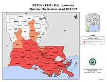
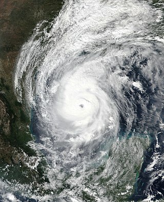
Hurricane Isidore was a powerful tropical cyclone that caused widespread flooding and heavy damage across Mexico, Cuba, and the United States in September 2002. The ninth named storm and the second hurricane in the 2002 Atlantic hurricane season, and the fifth of eight named storms to occur in September of that year, Isidore peaked as a Category 3 hurricane, causing damage, as well as four fatalities in Jamaica, Cuba, Mexico, and the United States. Isidore is also noted for threatening to strike the northern Gulf Coast as a Category 4 hurricane, however, the storm struck the region as a moderately-strong tropical storm, due to a track change that brought the storm over the Yucatán Peninsula for over a day, which significantly weakened the cyclone in the process. The primary impact from the storm was the heavy rainfall, which fell across southeast Mexico, and also from the central United States Gulf coast into the Ohio Valley.

<span class="mw-page-title-main">1895 Atlantic hurricane season</span> Hurricane season in the Atlantic Ocean

The 1895 Atlantic hurricane season ran through the summer and the first half of fall in 1895. The season was a fairly inactive one, with six storms forming, only two of which became hurricanes.

<span class="mw-page-title-main">2008 Atlantic hurricane season</span> Hurricane season in the Atlantic Ocean

The 2008 Atlantic hurricane season was the most destructive Atlantic hurricane season since 2005, causing over 1,000 deaths and nearly $50 billion in damage. The season ranked as the third costliest ever at the time, but has since fallen to ninth costliest. It was an above-average season, featuring sixteen named storms, eight of which became hurricanes, and five which further became major hurricanes. It officially started on June 1 and ended on November 30. These dates conventionally delimit the period of each year when most tropical cyclones form in the Atlantic basin. However, the formation of Tropical Storm Arthur caused the season to start one day early. It was the only year on record in which a major hurricane existed in every month from July through November in the North Atlantic. Bertha became the longest-lived July tropical cyclone on record for the basin, the first of several long-lived systems during 2008.

<span class="mw-page-title-main">Hurricane Lili (1996)</span> Category 3 Atlantic hurricane in 1996

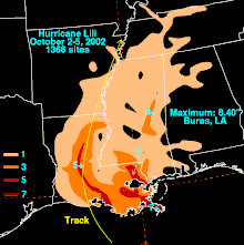
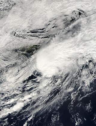
Hurricane Lili was a relatively long-lived hurricane of the 1996 Atlantic hurricane season that affected countries from Central America to the United Kingdom. Lili formed on October 14 from a tropical wave, which emerged from the coast of west Africa on October 4. After the storm formed, further strengthening of Lili was gradual, first to tropical storm status on October 16 and then to hurricane status on October 17. The next day, Lili struck Cuba and moved across the central portion of the island, the first hurricane to hit the country since Hurricane Kate in 1985. After emerging into the Atlantic Ocean, the hurricane accelerated northeastward, briefly peaking as a category 3 hurricane on the Saffir-Simpson Hurricane Scale near the Bahamas. For almost an entire week, Hurricane Lili oscillated in intensity while fluctuating several times in forward speed. About two weeks passed before Lili transitioned into an extratropical storm north of the Azores on October 27, which subsequently moved across Ireland and Great Britain.

<span class="mw-page-title-main">Tropical Storm Debby (1994)</span> Atlantic tropical storm in 1994

Tropical Storm Debby was a weak but costly tropical cyclone that affected the Lesser Antilles in September 1994. It was the fourth named tropical storm of the 1994 Atlantic hurricane season; it developed on September 9 east of Barbados. Debby made landfall on Saint Lucia early on September 10, producing heavy rainfall and tropical storm-force wind gusts. The rains caused flooding and landslides, damaging about half of the island's banana plantations. Several villages were isolated after roads and bridges were damaged. Damage totaled about $103 million (1994 USD). On nearby Dominica, Debby damaged crops and fisheries.

<span class="mw-page-title-main">Tropical Storm Helene (2000)</span> Atlantic tropical storm in 2000

Tropical Storm Helene was a long-lived tropical cyclone that oscillated for ten days between a tropical wave and a 70 mph (110 km/h) tropical storm. It was the twelfth tropical cyclone and eighth tropical storm of the 2000 Atlantic hurricane season, forming on September 15 east of the Windward Islands. After degenerating into a tropical wave, the system produced flooding and mudslides in Puerto Rico. It reformed into a tropical depression on September 19 south of Cuba, and crossed the western portion of the island the next day while on the verge of dissipation. However, it intensified into a tropical storm in the Gulf of Mexico, reaching its peak intensity while approaching the northern Gulf Coast.

<span class="mw-page-title-main">Hurricane Felix</span> Category 5 Atlantic hurricane in 2007

Hurricane Felix was an extremely powerful Category 5 Atlantic hurricane which was the southernmost-landfalling Category 5 storm on record, surpassing Hurricane Edith of 1971. It was the sixth named storm, second hurricane, and second Category 5 hurricane of the 2007 Atlantic hurricane season. Felix formed from a tropical wave on August 31, passing through the southern Windward Islands on September 1 before strengthening to attain hurricane status. On the next day, Felix rapidly strengthened into a major hurricane, and early on September 3 it was upgraded to Category 5 status; at 2100 UTC on the same day, the hurricane was downgraded to Category 4 status, but strengthened into a Category 5 hurricane for the second and final time by the morning of September 4.

<span class="mw-page-title-main">Hurricane Humberto (2007)</span> Category 1 Atlantic hurricane in 2007

Hurricane Humberto was a Category 1 hurricane that formed and intensified faster than any other North Atlantic tropical cyclone on record, before landfall. The eighth named storm and third hurricane of the 2007 Atlantic hurricane season, Humberto developed on September 12, 2007, in the northwestern Gulf of Mexico. The tropical cyclone rapidly strengthened and struck High Island, Texas, with winds of about 90 mph (140 km/h) early on September 13. It steadily weakened after moving ashore, and on September 14, Humberto began dissipating over northwestern Georgia as it interacted with an approaching cold front.

<span class="mw-page-title-main">Hurricane Noel</span> Category 1 Atlantic hurricane in 2007

Hurricane Noel was a deadly tropical cyclone that carved a path of destruction across the Atlantic Ocean from the Caribbean Sea to Newfoundland in late October 2007. The sixteenth tropical depression, fourteenth named storm, and the sixth hurricane of the 2007 Atlantic hurricane season, Noel formed on October 27 from the interaction between a tropical wave and an upper-level low in the north-central Caribbean. It strengthened to winds of 60 mph (97 km/h) before making landfall on western Haiti and the north coast of eastern Cuba. Noel turned northward, and on November 1, it attained hurricane status. The hurricane accelerated northeastward after crossing the Bahamas, and on November 2, it transitioned into an extratropical cyclone.

<span class="mw-page-title-main">Hurricane Fox (1952)</span> Category 4 Atlantic hurricane in 1952

Hurricane Fox was a powerful and destructive tropical cyclone that crossed central Cuba in October 1952. The seventh named storm, sixth hurricane, and third major hurricane of the 1952 Atlantic hurricane season, it was the strongest and deadliest system of the season. Fox developed northwest of Cartagena, Colombia, in the southern Caribbean Sea. It moved steadily northwest, intensifying to a tropical storm on October 21. The next day, it rapidly strengthened into a hurricane and turned north passing closely to Grand Cayman, Cayman Islands. The cyclone attained peak winds of 145 mph (233 km/h) as it struck Cayo Guano del Este off the coast of Cienfuegos. Fox made landfall on Cuba at maximum intensity, producing peak gusts of 170–180 mph (270–290 km/h). It weakened over land, but it re-strengthened as it turned east over the Bahamas. On October 26, it weakened and took an erratic path, dissipating west-southwest of Bermuda on October 28.

<span class="mw-page-title-main">Meteorological history of Hurricane Gustav</span>

The meteorological history of Hurricane Gustav spanned eleven days, from August 25 to September 4, 2008. The tropical disturbance which eventually spawned Hurricane Gustav gathered on August 16, southwest of the Cape Verde islands, but was slow to develop as it trekked west across the Atlantic. Upon reaching the warm waters of Caribbean Sea it began to organize and became a tropical depression on August 25. It quickly strengthened to a tropical storm, and then a hurricane, before making landfall on Haiti's southwest peninsula. Gustav was severely disrupted by Hispaniola's mountains and stalled, disorganized, in the Gulf of Gonâve between August 26 and 27.

<span class="mw-page-title-main">Hurricane Isaac (2012)</span> Category 1 Atlantic hurricane in 2012

Hurricane Isaac was a deadly and destructive tropical cyclone that came ashore in the U.S. state of Louisiana during August 2012. The ninth named storm and fourth hurricane of the annual hurricane season, Isaac originated from a tropical wave that moved off the west coast of Africa on August 16. Tracking generally west, a broad area of low pressure developed along the wave axis the next day, and the disturbance developed into a tropical depression early on August 21 while several hundred miles east of the Lesser Antilles. The system intensified into a tropical storm shortly thereafter, but high wind shear initially prevented much change in strength.

<span class="mw-page-title-main">Hurricane Delta</span> Category 4 Atlantic hurricane in 2020

Hurricane Delta was the record-tying fourth named storm of 2020 to make landfall in Louisiana, as well as the record-breaking tenth named storm to strike the United States in that year. The twenty-sixth tropical cyclone, twenty-fifth named storm, tenth hurricane, and third major hurricane of the record-breaking 2020 Atlantic hurricane season, Delta formed from a tropical wave which was first monitored by the National Hurricane Center (NHC) on October 1. Moving westward, the tropical wave began to quickly organize. A well-defined center of circulation formed with sufficiently organized deep convection on October 4, and was designated as Tropical Depression Twenty-six and soon thereafter, Tropical Storm Delta. Extremely rapid intensification ensued throughout October 5 into October 6, with Delta becoming a Category 4 hurricane within 28 hours of attaining tropical storm status. The rate of intensification was the fastest in the Atlantic basin since Hurricane Wilma in 2005. After peaking in intensity however, an unexpected increase in wind shear and dry air quickly weakened the small storm before it made landfall in Puerto Morelos, Mexico as a Category 2 hurricane with 105 mph (169 km/h) winds. It weakened some more over land before emerging into the Gulf of Mexico, where it was downgraded to a Category 1 hurricane. After that, it began to restrengthen, regaining Category 3 status late on October 8. It then turned northward and reached a secondary peak intensity of 953 mbar (28.14 inHg) and winds of 120 mph early on October 9. Delta then began to turn more north-northeastward into an area of cooler waters, higher wind shear, and dry air, causing it to weaken back to Category 2 status. Delta then made landfall at 23:00 UTC near Creole, Louisiana with winds of 100 mph (160 km/h) and a pressure of 970 mbar (29 inHg). The storm began to weaken more rapidly after landfall, becoming post-tropical just 22 hours later.

References

  1. 1 2 3 4 5 6 7 8 9 10 11 12 13 14 15 16 17 18 19 20 Miles Lawrence (2002). "National Hurricane Center Tropical Cyclone Report" (PDF). National Hurricane Center. Retrieved 2015-05-26.
  2. 1 2 3 4 "Lili leaves trail of destruction in Eastern Caribbean". Jamaica Observer. Associated Press. 2002. Archived from the original on 2016-03-04. Retrieved 2008-04-02.
  3. "Lili killed 4 in Haiti;deaths unreported for a week". USA Today. Associated Press. 2002-10-05. Retrieved 2008-03-23.
  4. Blake, Eric S; Landsea, Christopher W; Gibney, Ethan J (August 2011). Costliest U.S. Hurricanes 1900 - 2010 (unadjusted): Table 3a: The 30 costliest mainland United States tropical cyclones, 1900-2010, (not adjusted for inflation) (PDF). National Hurricane Center/National Climatic Data Center (NOAA Technical Memorandum NWS NHC-6). United States National Oceanic and Atmospheric Administration's National Weather Service. p. 11. Archived (PDF) from the original on October 31, 2012. Retrieved November 27, 2012.
  5. Lixion Avila; Eric Blake (2002). "National Hurricane Center Public Advisory #1". National Hurricane Center. Retrieved 2008-03-22.
  6. Stacey Stewart (2002). "National Hurricane Center Public Advisory #9A". National Hurricane Center. Retrieved 2008-03-22.
  7. Stacey Stewart (2002). "National Hurricane Center Public Advisory #13". National Hurricane Center. Retrieved 2008-03-22.
  8. Brian Jarvinen; Robert Molleda (2002). "National Hurricane Center Public Advisory #15". National Hurricane Center. Retrieved 2008-03-22.
  9. Brian Jarvinen; Robert Molleda (2002). "National Hurricane Center Forecast Discussion #15". National Hurricane Center. Retrieved 2008-03-22.
  10. James Franklin (2002). "National Hurricane Center Public Advisory #36". National Hurricane Center. Retrieved 2008-03-22.
  11. Jack Beven (2002). "National Hurricane Center Public Advisory #40A". National Hurricane Center. Retrieved 2008-03-22.
  12. Jack Beven (2002). "National Hurricane Center Public Advisory #41". National Hurricane Center. Retrieved 2008-03-22.
  13. Jack Beven (2002). "National Hurricane Center Public Advisory #44". National Hurricane Center. Retrieved 2008-03-22.
  14. Jack Beven (2002). "National Hurricane Center Forecast Discussion #44". National Hurricane Center. Retrieved 2008-03-22.
  15. Jack Beven (2002). "National Hurricane Center Public Advisory #45". National Hurricane Center. Retrieved 2008-03-22.
  16. Richard Pasch (2002). "National Hurricane Center Public Advisory #48". National Hurricane Center. Retrieved 2008-03-22.
  17. Chris Cappella. Scientists don't yet know why Lili suddenly collapsed. Retrieved on 2008-05-08.
  18. Adele Marie Babin. Characteristics of Hurricane Lili'S Intensity Changes. Archived 2016-03-03 at the Wayback Machine Retrieved on 2008-05-08.
  19. Lixion Avila (2002). "National Hurricane Center Public Advisory #49". National Hurricane Center. Retrieved 2008-03-22.
  20. Lixion Avila (2002). "National Hurricane Center Public Advisory #49B". National Hurricane Center. Retrieved 2008-03-27.
  21. 1 2 3 Horace Helps (2002). "News: Caribbean: Tropical Storm Lili — September 2002, Hurricane Lili belts Caymans, 4 dead in Jamaica". Relief Web. Retrieved 2008-04-06.
  22. "United States to move Cuba base detainees if storm nears". The Guardian. London. Reuters. 2002-09-25. Retrieved 2008-03-27.
  23. "Gulf Coast under Lili watch". The St. Petersburg Times. Associated Press. 2002. Archived from the original on 2010-12-31. Retrieved 2008-03-27.
  24. 1 2 3 Jeffrey Gettleman (2002-10-03). "Thousands Seek Safety as Hurricane Nears Gulf Coast". The New York Times. Retrieved 2008-03-27.
  25. 1 2 Cable News Network (2002-10-03). "Red Cross shelters thousands from the storm". Cable News Network. Archived from the original on 2008-04-05. Retrieved 2008-03-27.
  26. 1 2 Bonnie Gillespie (2002). "Team Louisiana Weathers Hurricane Lili". The Red Cross. Archived from the original on 2008-03-13. Retrieved 2008-04-03.
  27. David Cohen (2002-10-02). "Hurricane Lili closes shuttle Mission Control". New Scientist. Retrieved 2012-04-21.
  28. KXAS (2002). "Hurricane Lili Makes Landfall Into Louisiana Coast". National Broadcasting Company. Archived from the original on 2002-10-16. Retrieved 2008-03-28.
  29. Mike Brassfield (2002). "Hurricane Lili runs out of steam". The St. Petersburg Times. Archived from the original on 2011-05-23. Retrieved 2008-03-28.
  30. Gabrielle Maple (2002). "Back to Back". The Southern Digest. Archived from the original on 2007-06-07. Retrieved 2008-03-27.
  31. Jeremy Osborne (2002). "Texas Task Force Sent to Galveston". The Batt. Archived from the original on 2013-08-16. Retrieved 2008-03-27.
  32. Jeff Roper (2002). "Hurricane Lili cancels two games". The Vanguard. Archived from the original on 2016-02-02. Retrieved 2008-03-27.
  33. Lixion Avila; Jack Beven; James Franklin; Miles Lawrence; Richard Pasch; Stacey Stewart (2002). "Summary of Tropical Cyclone Activity of 2002". National Hurricane Center. Retrieved 2008-04-02.
  34. 1 2 3 4 5 6 7 8 9 Caribbean Disaster Emergency Response Agency (2002). "Situation Reports:Caribbean:Tropical Storm Lili". Relief Web. Retrieved 2008-04-04.
  35. Dunn, Gordon E; Moore, Paul L; Clark, Gilbert B; Frank, Neil L; Hill, Elbert C; Kraft, Raymond H; Sugg, Arnold L (1964). "The Hurricane Season of 1963" (PDF). Monthly Weather Review. 92 (3). American Meteorological Society: 136. Bibcode:1964MWRv...92..128D. doi:10.1175/1520-0493-92.3.128. ISSN   0027-0644. Archived (PDF) from the original on June 9, 2012. Retrieved May 13, 2012.
  36. Brown, Daniel P (December 17, 2007). Tropical Cyclone Report: Hurricane Noel (PDF) (Report). United States National Hurricane Center. p. 4. Archived from the original on June 9, 2012. Retrieved June 1, 2012.
  37. Stewart, Stacy R (April 3, 2017). Tropical Cyclone Report: Hurricane Matthew (PDF) (Report). United States National Hurricane Center. p. 4. Archived from the original on June 9, 2012. Retrieved April 6, 2017.
  38. Finnigan, Sean (October 4, 2002). Hurricane Lili almost drowns Camp-Perin, Haiti (PDF) (Report). Organisation for the Rehabilitation of the Environment. p. 1. Archived from the original on June 9, 2012. Retrieved June 9, 2012.
  39. Brown, Daniel P; Kimberlain, Todd B (March 27, 2009). Tropical Cyclone Report: Hurricane Hanna (PDF) (Report). United States National Hurricane Center. Archived from the original on June 9, 2012. Retrieved June 1, 2012.
  40. Beven II, John L; Kimberlain, Todd B (January 22, 2009). Tropical Cyclone Report: Hurricane Gustav (PDF) (Report). United States National Hurricane Center. p. 4. Archived from the original on June 9, 2012. Retrieved June 1, 2012.
  41. Jeff Masters and Bob Henson (August 24, 2020). "Laura expected to hit Gulf Coast as at least a Category 2 hurricane". Yale Climate Connections. Retrieved August 24, 2020.
  42. Roth, David M. (January 3, 2023). "Tropical Cyclone Point Maxima". Tropical Cyclone Rainfall Data. United States Weather Prediction Center. Retrieved January 6, 2023.PD-icon.svg This article incorporates text from this source, which is in the public domain.
  43. Organization for the Rehabilitation of the Environment (2002). "Hurricane Lili Was Accompanied by Torrential Rains As it Passed Over Haiti". Organization for the Rehabilitation of the Environment. Retrieved 2008-04-05.
  44. 1 2 "Lili killed 4 in Haiti; deaths unreported for a week". USA Today. Associated Press. 2002-10-05. Retrieved 2008-04-05.
  45. 1 2 Pan American Health Organization (2002). "Hurricane Lili in the Caribbean". World Health Organization. Retrieved 2008-04-06.
  46. 1 2 3 International Federation of the Red Cross (2002). "Press Releases: Caribbean: Tropical Storm Isidore — September 2002, Cuban community left reeling by Isidore and Lili". Relief Web. Retrieved 2008-04-06.
  47. International Federation of the Red Cross (2002). "Situation Reports: Caribbean: Tropical Storm Isidore — September 2002, Caribbean: Hurricane Lili Information Bulletin No. 03/02". Relief Web. Retrieved 2008-04-06.
  48. Office of the Coordination of Humanitarian Affairs (2002). "Caribbean — Tropical Storm Lili OCHA Situation Report No. 8". Relief Web. Retrieved 2008-04-06.
  49. 1 2 3 4 5 National Weather Service Forecast Office, Lake Charles, Louisiana (2002). "LILI". National Weather Service. Archived from the original on 2003-04-17. Retrieved 2008-04-08.{{cite web}}: CS1 maint: multiple names: authors list (link)
  50. Kent Kuyper; Marty Mayeaux; Montra Lockwood; Donovan Landreneau; Joe Rua; Lance Escude; Roger Erickson (2002). "Lili '02". NWS WFO Lake Charles, Louisiana. Archived from the original on 2002-12-26. Retrieved 2008-04-08.
  51. National Weather Service Forecast Office, New Orleans, Louisiana (2002). "Post Tropical Cyclone Report...Hurricane Lili". National Oceanic and Atmospheric Administration. Archived from the original on 2002-10-16. Retrieved 2008-04-12.{{cite web}}: CS1 maint: multiple names: authors list (link)
  52. Mike Brassfield (2002). "Hurricane Lili Runs Out of Steam". St. Petersburg Times. Archived from the original on 2011-05-23. Retrieved 2008-04-09.
  53. Federal Emergency Management Agency (2002). "Louisiana Aid Deadline Looms, 153,000 Have Applied". Federal Emergency Management Agency. Archived from the original on 2007-10-31. Retrieved 2008-04-10.
  54. The New Orleans Channel (2002). "Federal Emergency Management Agency Fans Out After Storms". WDSU. Archived from the original on 2011-07-16. Retrieved 2008-04-08.
  55. Federal Emergency Management Agency (2002). "Lili Recovery at More Than a Quarter Billion Dollars". Federal Emergency Management Agency. Archived from the original on 2007-10-31. Retrieved 2008-04-10.
  56. WTVY (2002). "Hurricane Lili Aid". WTVY. Archived from the original on 2013-02-09. Retrieved 2008-04-09.
  57. Melissa Simas (2002). "Utility Workers on Ready for Storm Damage". KAIT. Archived from the original on 2015-12-28. Retrieved 2008-04-08.
  58. Cleco Corporation (2002). "Cleco Power". Cleco Corporation. Retrieved 2008-04-10.
  59. Federal Emergency Management Agency (2002). "SWLA Electric Corp To Receive $8.6 million Federal Emergency Management Agency Public Assistance Grant". Federal Emergency Management Agency. Archived from the original on 2007-10-31. Retrieved 2008-04-10.
  60. Storm Work (2002). "Helping Customers and Communities" (PDF). Storm Work. Archived from the original (PDF) on 2005-03-07. Retrieved 2008-04-10.
  61. Gaye Farris (2002). "USGS scientists monitor coastal damage from Hurricane Lili". USGS. Retrieved 2008-04-10.
  62. National Hurricane Operations Plan (PDF) (Report). Washington, D.C.: NOAA Office of the Federal Coordinator for Meteorological Services and Supporting Research. May 2004. p. 3-9. Retrieved April 10, 2024.
  63. Gary Padgett; Jack Beven; James Lewis Free (December 6, 2006). "Subject: B3) What names have been retired in the Atlantic and East Pacific basin?". FAQ: Hurricanes, Typhoons, and Tropical Cyclones. Atlantic Oceanographic and Meteorological Laboratory Hurricane Research Division. Archived from the original on May 6, 2009. Retrieved April 10, 2024.