1933 Treasure Coast hurricane

Last updated

Map key
  Tropical depression (≤38 mph, ≤62 km/h)
  Tropical storm (39–73 mph, 63–118 km/h)
  Category 1 (74–95 mph, 119–153 km/h)
  Category 2 (96–110 mph, 154–177 km/h)
  Category 3 (111–129 mph, 178–208 km/h)
  Category 4 (130–156 mph, 209–251 km/h)
  Category 5 (≥157 mph, ≥252 km/h)
  Unknown
Storm type
Disc Plain black.svg Tropical cyclone
Solid black.svg Subtropical cyclone
ArrowUp.svg Extratropical cyclone, remnant low, tropical disturbance, or monsoon depression

The origins of the hurricane were from a tropical wave that possibly spawned a tropical depression on August 27, although there was minimal data over the next few days as it tracked to the west-northwest. On August 31, a nearby ship reported gale-force winds, which indicated that a tropical storm had developed to the east-northeast of the Lesser Antilles. Based on continuity, it is estimated the storm attained hurricane status later that day. Moving quickly to the west-northwest, the storm passed north of the Lesser Antilles and Puerto Rico. Early on September 2, a ship called the Gulfwing reported a barometric pressure of 978 mb (28.9 inHg), which confirmed that the storm attained hurricane status. [3] After passing north of the Turks and Caicos islands, [4] the hurricane struck Eleuthera and Harbour Island in the Bahamas on September 3, the latter at 11:00  UTC. A station on the latter island reported a pressure of 27.90 inHg (945 mb) during the half-hour-long passage of the eye. [5] Based on the pressure and the small size of the storm, it is estimated the hurricane struck Harbour Island with peak winds of 140 mph (220 km/h), making it the equivalent of a modern Category 4 hurricane on the Saffir-Simpson scale. Interpolation suggested that the storm reached major hurricane status, or Category 3 status, on September 2. [3]

The hurricane initially followed the course of another hurricane that passed through the area in late August, which ultimately struck Cuba and Texas. This hurricane instead maintained a general west-northwest track. [4] [6] After moving through the northern Bahamas, the hurricane weakened slightly before making landfall at Jupiter, Florida, at 05:00 UTC on September 4. A station there reported a pressure of 27.98 inHg (948 mb) during a 40-minute period of the eye's passage; this suggested a landfall strength of 125 mph (205 km/h). At the time, the radius of maximum winds was an estimated 15  nmi (15 mi, 30 km), which was smaller than average. [3] [7] After landfall, the hurricane weakened rapidly while crossing the state. It briefly emerged into the Gulf of Mexico as a tropical storm early on September 5. A few hours later while continuing to the northwest, it made another landfall near Rosewood—a ghost town in Levy County, east of Cedar Key—with winds of about 65 mph (100 km/h). Turning to the north, the storm slowly weakened as it crossed into Georgia, dissipating on September 7 near Augusta. [2]

Preparations

Rainfall map for the hurricane in the southeastern United States September 1933 Florida hurricane rainfall.png
Rainfall map for the hurricane in the southeastern United States

On September 2, a fleet of eight aircraft evacuated all white residents from West End, Grand Bahama, to Daytona Beach, Florida. [8] While the storm was near peak intensity on September 3, the Weather Bureau issued hurricane warnings from Miami to Melbourne, Florida, with storm warnings extending northward to Jacksonville. Later that day, storm warnings, were issued from Key West to Cedar Key. [4] About 2,500 people evacuated by train from areas around Lake Okeechobee. [9] By evening on September 3, high tides sent sea spray over coastal seawalls in Palm Beach County as residents boarded up buildings; structures on Clematis Street in West Palm Beach were said to be a "solid front" of plywood. [10] Along the coast, observers reported very rough seas as the eye neared land. [11]

Impact

The Bahamas

The powerful hurricane moved over or near several islands in the Bahamas. Winds on Spanish Wells and Harbour Island were both estimated at around 140 mph (225 km/h). [3] [5] Winds reached 110 mph (180 km/h) at Governor's Harbour, 100 mph (160 km/h) on Eleuthera, and 120 mph (190 km/h) on the Abaco Islands. [5] [12] [13] The storm was farther away from Nassau, where winds reached 61 mph (98 km/h). [3] [12] The hurricane damaged a lumber mill on Abaco, washing away a dock. Heavy damage occurred on Harbour Island, including to several roofs, the walls of government buildings, and the water system. The hurricane destroyed four churches and 37 houses, leaving 100 people homeless. A 1+12-mile-long (2.4 km) road on Eleuthera was destroyed. Several islands sustained damage to farms, including the total loss of various fruit trees on Russell Island. Despite Category 4 winds on Spanish Wells, only five houses were destroyed, although most of the remaining dwellings lost their roofs. Collectively between North Point, James Cistern, and Gregory Town on Eleuthera, the storm destroyed 55 houses and damaged many others. On Grand Bahama, where a 9-to-12-foot-high (2.7 to 3.7 m) storm surge was reported, half of the houses were destroyed, as were 13 boats and two planes, and most docks were wrecked. [5]

Florida

When the storm moved ashore in Florida, winds reached an estimated 125 mph (200 km/h) in Jupiter; these occurred after the eye passed. [4] [14] In West Palm Beach, anemometers measured at least 80-mile-per-hour (130 km/h) winds with gusts to 100 mph (160 km/h); barometers ranged from 28.64 to 28.78  inHg (970 to 975  mb ). [15] The storm produced the strongest winds in the city since the 1928 Okeechobee hurricane. [16] Winds were not as strong farther from the center; 40-to-45-mile-per-hour (64 to 72 km/h) winds were observed in Miami to the south, Titusville to the north, and Tampa on the west coast. [3] At Stuart the lowest atmospheric pressure was measured as 28.60 inHg (969 mb), [17] while Indiantown, on the edge of the eye, registered 28.25 inHg (957 mb). [18] Fort Pierce estimated peak winds of 80 to 90 mph (130 to 145 km/h), and pressures dipped to 29.14 inHg (987 mb). [19] Inland, winds near Lake Okeechobee peaked at only 60 mph (97 km/h). [20] The hurricane dropped heavy rainfall along its path, peaking at 17.8 in (450 mm) in Clermont. [6]

Crop damage was worst along the Indian River Lagoon; several farms in Stuart experienced total losses, and statewide, 16% of the citrus crop, or 4 million boxes, were destroyed. [4] Across southeastern Florida, the hurricane damaged 6,465 houses and destroyed another 383, [21] causing over $3 million in damage. [22] One person, an African American farm worker, was killed when his shack blew down in Gomez, [23] a brakeman died after seven railcars derailed, [24] and a child was killed by airborne debris. [14]

South Florida

At West Palm Beach, the majority of the damage was confined to vegetation. Several coconut and royal palms that withstood the 1928 hurricane snapped, littering streets with broken trunks. [16] Winds downed road signs on many streets, and floodwaters covered the greens on a local golf course. [25] Some garages and isolated structures, mostly lightweight, were partly or totally destroyed, along with a lumber warehouse. Some homes that lost roofing shingles had water damage to their interiors as well. [16] Nearby Lake Worth sustained extensive breakage of windows, including plate glass, and loss of tile and shingle roofing, but preparations reduced losses to just several thousand dollars, and no post-storm accidents took place. Strong winds snapped many light poles in the city, and trees and shrubs were broken or uprooted. [26] As in Lake Worth, officials in West Palm Beach credited preparations and stringent building codes with reducing overall damage. The city had learned from previous experience with severe storms in 1926, 1928, and 1929. [16] High tides eroded Ocean Boulevard at several spots and disrupted access to several bridges on the Lake Worth Lagoon. Winter estates and hotels on Palm Beach generally sustained little material damage, except to vegetation, and county properties went largely unscathed. [16]

Treasure Coast

In Martin and St. Lucie counties, the storm was considered among the worst on record. The storm leveled some homes and swept many others off their foundations. [27] Most structures in the worst-hit areas received at least minor damage, including the loss of tarpaper roofing and shingles. [28]

At Stuart, winds removed or badly damaged three-quarters of the roofs in town. The storm destroyed the third floor of the building that housed a bowling alley and the Stuart News, a local newspaper. [14] [25] In Stuart, the storm left 400 to 500 people homeless, up to nearly 10% of the population, which was 5,100 at the time. [14] [29] A major landmark, the multi-story Walter Kitching store, collapsed during the storm. An old laundromat was likewise leveled, a private airport destroyed, and a water tower downed. Apartments and large hotels also incurred significant damage from rainwater. [28] The county jail lost all its walls, but inmates opted to remain inside. In town thousands of coconuts, hurled by strong winds from trees, were salvaged by poor black residents. The St. Lucie River reportedly disgorged fish. [17] Many chicken coops in Stuart were destroyed, and the local chicken population was scattered and dispersed as far as Indiantown. [14] [17]

Just to the south, at Olympia, an abandoned settlement also known as Olympia Beach, strong winds leveled the old Olympia Inn, a gas station, and the second floor of a pharmaceutical building. Winds also tore the roof off an ice plant. [25] [23] A bridge leading to the barrier island from Olympia was partly wrecked; the bridge tender survived by gripping the railing during the storm. Winds leveled his nearby home. [23] According to the Monthly Weather Review, some of the most severe damage from the storm in Florida was at Olympia. [4] At Hobe Sound, which experienced the storm's eye for five minutes, the hurricane inflicted severe damage and was considered by lifelong residents the worst storm in 50 years. Landmarks that withstood the 1928 Okeechobee hurricane were felled. [30] Most structures west of the Florida East Coast Railway were severely damaged or wrecked. A filling station was scattered, and the platform at the local railroad station was strewn across the tracks. A railcar from West Palm Beach, blown north 30 mi (48 km), crashed into the platform, leaving a mass of wreckage that required several hours' manpower for removal. [31] The storm left many homes in Hobe Sound uninhabitable, forcing crews to tear them down. Winter estates on the island, however, were better built and little damaged, [23] though downed Australian pines, other trees, and electrical wires left coastal roadways essentially impassable. A 10-car garage at the Island Inn was flattened. [31]

While Stuart and Hobe Sound sustained significant damage, Port Salerno suffered minimally. [23] At Palm City the storm badly damaged structures and crops. A store sustained damage to such a degree that it was unusable, and a riverfront two-story home was leveled; on the latter's grounds all palm trees were downed. A well-constructed home, one of the sturdiest in Palm City, incurred only superficial damage, however. Most small houses in the area lost their roofs or were shifted on their foundations. The Niagara Fruit Company lost all its outbuildings and sustained severe damage to its main house. Many trees on site and on nearby farms were felled as well. At Tropical Farms most large properties were rendered uninhabitable, while a number of smaller homes were destroyed. Citrus trees, mainly grapefruit and orange, were prostrated, and the St. Lucie River overflowed its banks, submersing several properties. [32] At Sewall's Point mansions were mostly negligibly damaged, except for losses of ornamental vegetation. 40-foot-tall (12 m) queen palms were felled, along with many tall coconut palms; several of the latter species were also left standing at an incline. Dozens of Australian pines were leveled as well. [33]

Inland, at Indiantown, the storm wrecked outbuildings such as sheds, garages, and shacks, but otherwise did little damage to larger structures. The eye passed just north of town, causing a lull over rural land. [18]

Between Jupiter and Fort Pierce, the storm knocked down power and telegraph lines. [4] In the latter city, high waves washed out a portion of the causeway. [34] In the 1980s, an elderly resident recalled that the storm was the most severe on record in Fort Pierce. [27]

Elsewhere

High rainfall caused flooding across Florida, notably near Tampa where waters reached 9 ft (2.7 m) deep. High rainfall of over 7 in (180 mm) caused a dam operated by Tampa Electric Co. to break 3 mi (4.8 km) northeast of Tampa along the Hillsborough River. The break resulted in severe local damage, [14] [24] flooding portions of Sulphur Springs. Workers attempted to save the dam with sandbags, and after the break, most residents in the area were warned of the approaching flood. Over 50 homes were flooded, forcing about 150 people to evacuate. [35] Outside Florida, the storm produced winds of 48 and 51 mph (77 and 82 km/h) in Savannah, Georgia, and Charleston, South Carolina, respectively. In the latter city, the storm spawned a tornado, [3] which caused about $10,000 in property damage. [24] Heavy rainfall occurred along the Georgia and South Carolina coasts, reaching over 12 in (300 mm). Light rainfall also extended into North Carolina. [6]

Aftermath

In the Bahamas after the storm, a boat sailed from Nassau to deliver food and building materials to Eleuthera. [5]

After the storm, the National Guard offered shelters for at least 400 homeless residents in Stuart. [14] Of the 7,900 families adversely affected by the hurricane, 4,325 required assistance from the American Red Cross. [21] Farmers in Texas, also affected by a major hurricane, requested growers in Florida wait 15 days so they could sell their citrus crop that fell. [36] The damaged dam near Tampa initially resulted in waters from the Hillsborough River being pumped into the city's water treatment plant, and a new dam was eventually built in 1944. [37]

See also

Notes

  1. Tropical cyclones in the Atlantic basin were not formally named prior to World War II. Storms such as this one were denoted by their attributes, including coincidence with Catholic saints' feasts. [1]

Related Research Articles

<span class="mw-page-title-main">Hurricane Donna</span> Category 4 Atlantic hurricane in 1960

Hurricane Donna, known in Puerto Rico as Hurricane San Lorenzo, was the strongest hurricane of the 1960 Atlantic hurricane season, and caused severe damage to the Lesser Antilles, the Greater Antilles, and the East Coast of the United States, especially Florida, in August–September. The fifth tropical cyclone, third hurricane, and first major hurricane of the season, Donna developed south of Cape Verde on August 29, spawned by a tropical wave to which 63 deaths from a plane crash in Senegal were attributed. The depression strengthened into Tropical Storm Donna by the following day. Donna moved west-northwestward at roughly 20 mph (32 km/h) and by September 1, it reached hurricane status. Over the next three days, Donna deepened significantly and reached maximum sustained winds of 130 mph (210 km/h) on September 4. Thereafter, it maintained intensity as it struck the Lesser Antilles later that day. On Sint Maarten, the storm left a quarter of the island's population homeless and killed seven people. An additional five deaths were reported in Anguilla, and there were seven other fatalities throughout the Virgin Islands. In Puerto Rico, severe flash flooding led to 107 fatalities, 85 of them in Humacao alone.

<span class="mw-page-title-main">Hurricane Jeanne</span> Category 3 Atlantic hurricane in 2004

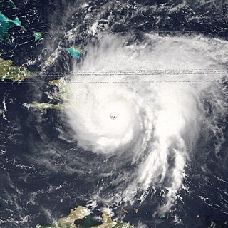
Hurricane Jeanne was a Category 3 hurricane that struck the Caribbean and the Eastern United States in September 2004. It was the deadliest hurricane in the Atlantic basin since Mitch in 1998. It was the tenth named storm, the seventh hurricane, and the fifth major hurricane of the season, as well as the third hurricane and fourth named storm of the season to make landfall in Florida. After wreaking havoc on Hispaniola, Jeanne struggled to reorganize, eventually strengthening and performing a complete loop over the open Atlantic. It headed westwards, strengthening into a Category 3 hurricane and passing over the islands of Great Abaco and Grand Bahama in the Bahamas on September 25. Jeanne made landfall later in the day in Florida just two miles from where Hurricane Frances had struck a mere three weeks earlier.

<span class="mw-page-title-main">Hurricane David</span> Category 5 Atlantic hurricane in 1979

Hurricane David was a devestating Atlantic hurricane which caused massive loss of life in the Dominican Republic in August 1979, and was the most intense hurricane to make landfall in the country in recorded history. A long-lived Cape Verde hurricane, David was the fourth named storm, second hurricane, and first major hurricane of the 1979 Atlantic hurricane season.

<span class="mw-page-title-main">1945 Atlantic hurricane season</span> Hurricane season in the Atlantic Ocean

The 1945 Atlantic hurricane season produced multiple landfalling tropical cyclones. It officially began on June 16 and lasted until October 31, dates delimiting the period when a majority of storms were perceived to form in the Atlantic Ocean. A total of 11 systems were documented, including a late-season cyclone retroactively added a decade later. Five of the eleven systems intensified into hurricanes, and two further attained their peaks as major hurricanes. Activity began with the formation of a tropical storm in the Caribbean on June 20, which then made landfalls in Florida and North Carolina at hurricane intensity, causing one death and at least $75,000 in damage. In late August, a Category 3 hurricane on the modern-day Saffir–Simpson hurricane wind scale struck the Texas coastline, with 3 deaths and $20.1 million in damage. The most powerful hurricane of the season, reaching Category 4 intensity, wrought severe damage throughout the Bahamas and East Coast of the United States, namely Florida, in mid-September; 26 people were killed and damage reached $60 million. A hurricane moved ashore the coastline of Belize in early October, causing one death, while the final cyclone of the year resulted in 5 deaths and $2 million in damage across Cuba and the Bahamas two weeks later. Overall, 36 people were killed and damage reached at least $82.85 million.

<span class="mw-page-title-main">1933 Atlantic hurricane season</span> Hurricane season in the Atlantic Ocean

The 1933 Atlantic hurricane season is the most active Atlantic hurricane season on record in terms of accumulated Cyclone Energy (ACE), with a total of 259. It also set a record for nameable tropical storms in a single season, 20, which stood until 2005, when there were 28 storms. The season ran for six months of 1933, with tropical cyclone development occurring as early as May and as late as November. A system was active for all but 13 days from June 28 to October 7.

<span class="mw-page-title-main">1932 Atlantic hurricane season</span> Hurricane season in the Atlantic Ocean

The 1932 Atlantic hurricane season featured several powerful storms, including the Cuba hurricane, which remains the deadliest tropical cyclone in the history of Cuba and among the most intense to strike the island nation. It was a relatively active season, with fifteen known storms, six hurricanes, and four major hurricanes. However, tropical cyclones that did not approach populated areas or shipping lanes, especially if they were relatively weak and of short duration, may have remained undetected. Because technologies such as satellite monitoring were not available until the 1960s, historical data on tropical cyclones from this period are often not reliable. The Atlantic hurricane reanalysis project discovered four new tropical cyclones, all of which were tropical storms, that occurred during the year. Two storms attained Category 5 intensity, the first known occurrence in which multiple Category 5 hurricanes formed in the same year. The season's first cyclone developed on May 5, while the last remaining system transitioned into an extratropical cyclone by November 13.

<span class="mw-page-title-main">1928 Atlantic hurricane season</span> Hurricane season in the Atlantic Ocean

The 1928 Atlantic hurricane season was a near average hurricane season in which seven tropical cyclones developed. Of these, six intensified into a tropical storm and four further strengthened into hurricanes. One hurricane deepened into a major hurricane, which is Category 3 or higher on the modern-day Saffir–Simpson scale. The first system, the Fort Pierce hurricane, developed near the Lesser Antilles on August 3. The storm crossed the Bahamas and made landfall in Florida. Two fatalities and approximately $235,000 in damage was reported. A few days after the first storm developed, the Haiti hurricane, formed near the southern Windward Islands on August 7. The storm went on to strike Haiti, Cuba, and Florida. This storm left about $2 million in damage and at least 210 deaths. Impacts from the third system are unknown.

<span class="mw-page-title-main">1928 Okeechobee hurricane</span> Category 5 Atlantic hurricane

The Okeechobee hurricane of 1928, also known as the San Felipe Segundo hurricane, was one of the deadliest hurricanes in the recorded history of the North Atlantic basin, and the fourth deadliest hurricane in the United States, only behind the 1900 Galveston hurricane, 1899 San Ciriaco hurricane, and Hurricane Maria. The hurricane killed an estimated 2,500 people in the United States; most of the fatalities occurred in the state of Florida, particularly in Lake Okeechobee. It was the fourth tropical cyclone, third hurricane, and only major hurricane of the 1928 Atlantic hurricane season. It developed off the west coast of Africa on September 6 as a tropical depression, but it strengthened into a tropical storm later that day, shortly before passing south of the Cape Verde islands. Further intensification was slow and halted late on September 7. About 48 hours later, the storm strengthened and became a Category 1 hurricane on the Saffir–Simpson hurricane wind scale. Still moving westward, the system reached Category 4 intensity before striking Guadeloupe on September 12, where it brought great destruction and resulted in 1,200 deaths. The islands of Martinique, Montserrat, and Nevis also reported damage and fatalities, but not nearly as severe as in Guadeloupe.

<span class="mw-page-title-main">Hurricane Erin (1995)</span> Category 2 Atlantic hurricane in 1995

Hurricane Erin was the first hurricane to strike the contiguous United States since Hurricane Andrew in 1992. The fifth tropical cyclone, fifth named storm, and second hurricane of the unusually active 1995 Atlantic hurricane season, Erin developed from a tropical wave near the southeastern Bahamas on July 31. Moving northwestward, the cyclone intensified into a Category 1 hurricane on the Saffir–Simpson scale near Rum Cay about 24 hours later. After a brief jog to the north-northwest on August 1, Erin began moving to the west-northwest. The cyclone then moved over the northwestern Bahamas, including the Abaco Islands and Grand Bahama. Early on August 2, Erin made landfall near Vero Beach, Florida, with winds of 85 mph (137 km/h). The hurricane weakened while crossing the Florida peninsula and fell to tropical storm intensity before emerging into the Gulf of Mexico later that day.

<span class="mw-page-title-main">1944 Cuba–Florida hurricane</span> Category 4 Atlantic hurricane in 1944

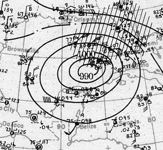
The 1944 Cuba–Florida hurricane was a large Category 4 tropical cyclone on the Saffir–Simpson hurricane wind scale that caused widespread damage across the western Caribbean Sea and Southeastern United States in October 1944. It inflicted over US$100 million in damage and caused at least 318 deaths, the majority of fatalities occurring in Cuba. One study suggested that an equivalent storm in 2018 would rank among the costliest U.S. hurricanes. The full extent of the storm's effects remains unclear due to a dearth of conclusive reports from rural areas of Cuba. The unprecedented availability of meteorological data during the hurricane marked a turning point in the United States Weather Bureau's ability to forecast tropical cyclones.

<span class="mw-page-title-main">1929 Bahamas hurricane</span> Category 4 Atlantic hurricane in 1929

The 1929 Bahamas hurricane was a high-end Category 4 tropical cyclone whose intensity and slow forward speed led to catastrophic damage in the Bahamas in September 1929, particularly on Andros and New Providence islands. Its erratic path and a lack of nearby weather observations made the hurricane difficult to locate and forecast. The storm later made two landfalls in Florida, killing eleven but causing comparatively light damage. Moisture from the storm led to extensive flooding over the Southeastern United States, particularly along the Savannah River. Across its path from the Bahamas to the mouth of the Saint Lawrence River, the hurricane killed 155 people.

<span class="mw-page-title-main">1932 Bahamas hurricane</span> Category 5 Atlantic hurricane in 1932

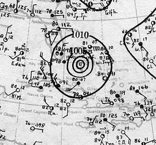
The 1932 Bahamas hurricane, also known as the Great Abaco hurricane of 1932, was a large and powerful Category 5 hurricane that struck the Bahamas at peak intensity. The fourth tropical storm and third hurricane in the 1932 Atlantic hurricane season, it was also one of two Category 5 hurricanes in the Atlantic Ocean that year, the other being the 1932 Cuba hurricane. The 1932 Bahamas hurricane originated north of the Virgin Islands, became a strong hurricane, and passed over the northern Bahamas before recurving. The storm never made landfall on the continental United States, but its effects were felt in the northeast part of the country and in the Bahamas, especially on the Abaco Islands, where damage was very great. To date, it is one of four Category 5 Atlantic hurricanes to make landfall in the Bahamas at that intensity, the others having occurred in 1933, 1992, and 2019.

<span class="mw-page-title-main">1921 Tampa Bay hurricane</span> Category 4 Atlantic hurricane in 1921

The Tampa Bay hurricane of 1921 was a destructive and deadly major hurricane which made landfall in the Tampa Bay area of Florida in late October 1921. The eleventh tropical cyclone, sixth tropical storm, and fifth hurricane of the season, the storm developed from a trough in the southwestern Caribbean Sea on October 20. Initially a tropical storm, the system moved northwestward and intensified into a hurricane on October 22 and a major hurricane by October 23. Later that day, the hurricane peaked as a Category 4 on the modern day Saffir–Simpson scale with maximum sustained winds of 140 mph (230 km/h). After entering the Gulf of Mexico, the hurricane gradually curved northeastward and weakened to a Category 3 before making landfall near Tarpon Springs, Florida, late on October 25. It was the first major hurricane to make landfall in the Tampa Bay area since the hurricane of 1848 and the last to date.

<span class="mw-page-title-main">Effects of Hurricane Wilma in Florida</span>

The effects of Hurricane Wilma in Florida resulted in the storm becoming one of the costliest tropical cyclones in Florida history. Wilma developed in the Caribbean Sea just southwest of Jamaica on October 15 from a large area of disturbed weather. After reaching tropical storm intensity on October 17 and then hurricane status on October 18, the system explosively deepened, peaking as the strongest tropical cyclone ever recorded in the Atlantic basin. Wilma then slowly weakened while trekking to the northwest and fell to Category 4 intensity by the time it struck the Yucatán Peninsula on October 22. Thereafter, a strong cold front swept the storm northeastward into Florida on October 24, with landfall occurring near Cape Romano as a Category 3 hurricane with winds of 120 mph (190 km/h). Wilma continued rapidly northeastward into the Atlantic Ocean and became extratropical on October 26.

<span class="mw-page-title-main">Hurricane Fox (1952)</span> Category 4 Atlantic hurricane in 1952

Hurricane Fox was a powerful and destructive tropical cyclone that crossed central Cuba in October 1952. The seventh named storm, sixth hurricane, and third major hurricane of the 1952 Atlantic hurricane season, it was the strongest and deadliest system of the season. Fox developed northwest of Cartagena, Colombia, in the southern Caribbean Sea. It moved steadily northwest, intensifying to a tropical storm on October 21. The next day, it rapidly strengthened into a hurricane and turned north passing closely to Grand Cayman, Cayman Islands. The cyclone attained peak winds of 145 mph (233 km/h) as it struck Cayo Guano del Este off the coast of Cienfuegos. Fox made landfall on Cuba at maximum intensity, producing peak gusts of 170–180 mph (270–290 km/h). It weakened over land, but it re-strengthened as it turned east over the Bahamas. On October 26, it weakened and took an erratic path, dissipating west-southwest of Bermuda on October 28.

The 1903 Florida hurricane was an Atlantic hurricane that caused extensive wind and flood damage on the Florida peninsula and over the adjourning Southeastern United States in early to mid September 1903. The third tropical cyclone and third hurricane of the season, this storm was first observed near Mayaguana island in the Bahamas early on September 9. Moving northwestward, it became a hurricane the next day and passed near Nassau. The cyclone then turned to the west-northwest on September 11 and passed just north of the Bimini Islands. As it crossed the Bahamas, the cyclone produced hurricane-force winds that caused damage to crops and buildings, but no deaths were reported over the island chain.

<span class="mw-page-title-main">1949 Florida hurricane</span> Category 4 Atlantic hurricane in 1949

The 1949 Florida hurricane, also known as the Delray Beach hurricane, caused significant damage in the southern portions of the state late in the month of August. The second recorded tropical cyclone of the annual hurricane season, the system originated from a tropical wave near the northern Leeward Islands on August 23. Already a tropical storm upon initial observations, the cyclone curved west-northwestward and intensified, becoming a hurricane on August 25. Rapid intensification ensued as the storm approached the central Bahamas early on August 26, with the storm reaching Category 4 hurricane strength later that day and peaking with maximum sustained winds of 130 mph (210 km/h) shortly after striking Andros. Late on August 26, the storm made landfall near Lake Worth, Florida, at the same intensity. The cyclone initially weakened quickly after moving inland, falling to Category 1 status early the next day. Shortly thereafter, the system curved northward over the Nature Coast and entered Georgia on August 28, where it weakened to a tropical storm. The storm then accelerated northeastward and became extratropical over New England by August 29. The remnants traversed Atlantic Canada and much of the Atlantic Ocean before dissipating near Ireland on September 1.

<span class="mw-page-title-main">Hurricane Andrew</span> Category 5 Atlantic hurricane in 1992

Hurricane Andrew was a small, but very powerful and destructive Category 5 Atlantic hurricane that struck the Bahamas, Florida, and Louisiana in August 1992. It is the most destructive hurricane to ever hit Florida in terms of structures damaged or destroyed, and remained the costliest in financial terms until Hurricane Irma surpassed it 25 years later. Andrew was also the strongest landfalling hurricane in the United States in decades and the costliest hurricane to strike anywhere in the country, until it was surpassed by Katrina in 2005. In addition, Andrew is one of only four tropical cyclones to make landfall in the continental United States as a Category 5, alongside the 1935 Labor Day hurricane, 1969's Camille, and 2018's Michael. While the storm also caused major damage in the Bahamas and Louisiana, the greatest impact was felt in South Florida, where the storm made landfall as a Category 5 hurricane, with 1-minute sustained wind speeds as high as 165 mph (266 km/h) and a gust as high as 174 mph (280 km/h). Passing directly through the cities of Cutler Bay and Homestead in Dade County, the hurricane stripped many homes of all but their concrete foundations and caused catastrophic damage. In total, Andrew destroyed more than 63,500 houses, damaged more than 124,000 others, caused $27.3 billion in damage, and left 65 people dead.

<span class="mw-page-title-main">1933 Cuba–Brownsville hurricane</span> Category 5 Atlantic hurricane in 1933

The 1933 Cuba–Brownsville hurricane was one of two storms in the 1933 Atlantic hurricane season to reach Category 5 intensity on the Saffir–Simpson scale. It formed on August 22 off the west coast of Africa, and for much of its duration it maintained a west-northwest track. The system intensified into a tropical storm on August 26 and into a hurricane on August 28. Passing north of the Lesser Antilles, the hurricane rapidly intensified as it approached the Turks and Caicos islands. It reached Category 5 status and its peak winds of 160 mph (260 km/h) on August 31. Subsequently, it weakened before striking northern Cuba on September 1 with winds of 120 mph (190 km/h). In the country, the hurricane left about 100,000 people homeless and killed over 70 people. Damage was heaviest near the storm's path, and the strong winds destroyed houses and left areas without power. Damage was estimated at $11 million.

<span class="mw-page-title-main">1933 Florida–Mexico hurricane</span> Category 1 Atlantic hurricane in 1933

The 1933 Florida–Mexico hurricane was the first of two Atlantic hurricanes to strike the Treasure Coast region of Florida in the very active 1933 Atlantic hurricane season. It was one of two storms that year to inflict hurricane-force winds over South Texas, causing significant damage there; the other occurred in early September. The fifth tropical cyclone of the year, it formed east of the Lesser Antilles on July 24, rapidly strengthening as it moved west-northwest. As it passed over the islands, it attained hurricane status on July 26, producing heavy rains and killing at least six people. Over the next three days, it moved north of the Caribbean, paralleling the Turks and Caicos Islands and the Bahamas. The storm produced extensive damage and at least one drowning as it crossed the Bahamas. On July 29, the cyclone came under the influence of changing steering currents in the atmosphere, which forced the storm into Florida near Hobe Sound a day later. A minimal hurricane at landfall, it caused negligible wind damage as it crossed Florida, but generated heavy rains along its path, causing locally severe flooding. The storm turned west, weakened to below hurricane status, and later exited the state north of Charlotte Harbor on July 31.

References

  1. "Definitions & Storm Names: How Are Hurricanes Named?". Hurricane FAQ. Miami, Florida: Atlantic Oceanographic and Meteorological Laboratory, Hurricane Research Division. Retrieved March 5, 2022.
  2. 1 2 "Atlantic hurricane best track (HURDAT version 2)" (Database). United States National Hurricane Center. April 5, 2023. Retrieved December 11, 2023.PD-icon.svg This article incorporates text from this source, which is in the public domain .
  3. 1 2 3 4 5 6 7 Landsea, Chris; Anderson, Craig; Bredemeyer, William; et al. 1933 Storm 11 (originally Storm 12) – 2012 Revision. Re-Analysis Project (Report). Miami, Florida: Atlantic Oceanographic and Meteorological Laboratory, Hurricane Research Division.
  4. 1 2 3 4 5 6 7 Mitchell 1933.
  5. 1 2 3 4 5 Neely 2006, pp. 84–8.
  6. 1 2 3 Schoner & Molansky 1956, p. 160.
  7. Landsea, Chris; Anderson, Craig; Bredemeyer, William; et al. (January 2022). Continental United States Hurricanes (Detailed Description). Re-Analysis Project (Report). Miami, Florida: Atlantic Oceanographic and Meteorological Laboratory, Hurricane Research Division . Retrieved December 11, 2023.
  8. "Pilots Leave Island in Face of Storm". The Palm Beach Post. West Palm Beach, Florida. September 4, 1933. Retrieved August 31, 2022 via Newspapers.com. Lock-green.svg
  9. "Throngs Flee as Hurricane Perils Florida". The Pittsburgh Post-Gazette. Associated Press. September 4, 1933. Retrieved September 21, 2013.
  10. "Residents Ready for Storm Winds as Boards Go Up". The Palm Beach Post. West Palm Beach, Florida. September 4, 1933. Retrieved August 31, 2022 via Newspapers.com. Lock-green.svg
  11. "Northwest Wind at Lauderdale". The Palm Beach Post. West Palm Beach, Florida. Associated Press. September 4, 1933. Retrieved August 31, 2022 via Newspapers.com. Lock-green.svg
  12. 1 2 "Nassau Reports Strong Winds". The Palm Beach Post. West Palm Beach, Florida. Associated Press. September 4, 1933. Retrieved August 31, 2022 via Newspapers.com. Lock-green.svg
  13. "City Near Storm Center". The Palm Beach Post. West Palm Beach, Florida. Associated Press. September 4, 1933. Retrieved August 31, 2022 via Newspapers.com. Lock-green.svg
  14. 1 2 3 4 5 6 7 Barnes 1998, p.  143.
  15. "Winds Were Felt over Large Area on East Coast". The Palm Beach Post. West Palm Beach, Florida. September 5, 1933. Retrieved August 31, 2022 via Newspapers.com. Lock-green.svg
  16. 1 2 3 4 5 "Storm's Damage Checked in City as Blow Passes". The Palm Beach Post. West Palm Beach, Florida. September 5, 1933. Retrieved August 31, 2022 via Newspapers.com. Lock-green.svg
  17. 1 2 3 "Hurricane highlights". Stuart Daily News. Vol. 8, no. 208 (Storm Extra ed.). Stuart, Florida. September 5, 1933. p. 1. Retrieved August 8, 2023 via Newspapers.com. Lock-green.svg
  18. 1 2 "Region of Lake Has Damage". Stuart Daily News. Vol. 8, no. 209. Stuart, Florida. September 6, 1933. p. 1. Retrieved August 8, 2023 via Newspapers.com. Lock-green.svg
  19. "Fort Pierce Area Has Heavy Damage". The Palm Beach Post. West Palm Beach, Florida. September 5, 1933. Retrieved August 31, 2022 via Newspapers.com. Lock-green.svg
  20. "Rain and Not Wind Damages Farm Area". The Palm Beach Post. West Palm Beach, Florida. September 6, 1933. Retrieved August 31, 2022 via Newspapers.com. Lock-green.svg
  21. 1 2 "Checkup on Losses in Hurricane Show Total to Be Larger". The Palm Beach Post. West Palm Beach, Florida. September 9, 1933. Retrieved August 31, 2022 via Newspapers.com. Lock-green.svg
  22. "Red Cross Workers Bring Aid to Storm Sufferers in Some Florida Sections". The Evening Post. Associated Press. September 7, 1933. Retrieved September 21, 2013.
  23. 1 2 3 4 5 "East Coast Hard Hit by Hurricane Winds; Storm Across State". The Palm Beach Post. West Palm Beach, Florida. September 5, 1933. Retrieved August 31, 2022 via Newspapers.com. Lock-green.svg
  24. 1 2 3 Souder 1933.
  25. 1 2 3 "Storm Sidelights". The Palm Beach Post. West Palm Beach, Florida. September 5, 1933. Retrieved August 31, 2022 via Newspapers.com. Lock-green.svg
  26. "Lake Worth Checks on Storm Damage". The Palm Beach Post. West Palm Beach, Florida. September 5, 1933. Retrieved August 31, 2022 via Newspapers.com. Lock-green.svg
  27. 1 2 Duedall & Williams 2002, p.  19.
  28. 1 2 "Here are some buildings hurt by Sunday blow". Stuart Daily News. Vol. 8, no. 208 (Storm Extra ed.). Stuart, Florida. September 5, 1933. p. 1. Retrieved August 8, 2023 via Newspapers.com. Lock-green.svg
  29. "Stuart Homeless Numerous; Help Is Sought Here". The Palm Beach Post. West Palm Beach, Florida. Associated Press. September 6, 1933. Retrieved August 31, 2022 via Newspapers.com. Lock-green.svg
  30. Lyons, Ernest (September 5, 1933). "This County Battered by West Indian Storm". Stuart Daily News. Vol. 8, no. 208 (Storm Extra ed.). Stuart, Florida. p. 1. Retrieved August 8, 2023 via Newspapers.com. Lock-green.svg
  31. 1 2 "Hobe Sound was badly damaged by heavy winds". Stuart Daily News . Vol. 8, no. 208 (Storm Extra ed.). Stuart, Florida. September 5, 1933. p. 4. Retrieved August 8, 2023 via Newspapers.com. Lock-green.svg
  32. "Palm City damaged". Stuart Daily News. Vol. 8, no. 209. Stuart, Florida. September 6, 1933. p. 1. Retrieved August 8, 2023 via Newspapers.com. Lock-green.svg
  33. "Sewell Point Suffered Severely". Stuart Daily News. Vol. 8, no. 209. Stuart, Florida. September 6, 1933. p. 1. Retrieved August 8, 2023 via Newspapers.com. Lock-green.svg
  34. "Gales Sweep Over Florida". The Pittsburgh Post-Gazette. Associated Press. September 5, 1933. Retrieved September 21, 2013.
  35. "Sulphur Springs Flooded as Huge Dam Bursts Open". The Evening Independent. September 8, 1933. Retrieved September 21, 2013.
  36. "Texas Appeals to Florida to Hold Up Fruit". The Sarasota Herald-Tribune. Associated Press. September 8, 1933. Retrieved September 21, 2013.
  37. History of the City of Tampa Water Department (PDF) (Report). Tampa, Florida Water Department. April 11, 2012. Archived from the original (PDF) on September 25, 2013. Retrieved September 21, 2013.

Bibliography

Hurricane Twelve
1933 Treasure Coast hurricane map.PNG
Surface weather analysis of the hurricane on September 3 near the Bahamas