Port Salerno, Florida

Last updated

Port Salerno, Florida
Martin County Florida Incorporated and Unincorporated areas Port Salerno Highlighted.svg
Location in Martin County and the state of Florida
Coordinates: 27°8′39″N80°11′30″W / 27.14417°N 80.19167°W / 27.14417; -80.19167
Country Flag of the United States.svg  United States
State Flag of Florida.svg  Florida
County   Martin
Area
[1]
  Total4.07 sq mi (10.54 km2)
  Land3.57 sq mi (9.23 km2)
  Water0.50 sq mi (1.31 km2)
Elevation
13 ft (4 m)
Population
 (2020) [2]
  Total10,401
  Density2,916.71/sq mi (1,126.29/km2)
Time zone UTC-5 (Eastern (EST))
  Summer (DST) UTC-4 (EDT)
ZIP codes
34992
34997 (Stuart)
Area code 772
FIPS code 12-58727 [3]
GNIS feature ID0289239 [4]

Port Salerno is an unincorporated community and census-designated place (CDP) in Martin County, Florida, United States. The population was 10,401 at the 2020 census. [2] It is part of the Port St. Lucie Metropolitan Statistical Area.

Contents

Geography

Port Salerno is located in eastern Martin County at 27°8′39″N80°11′30″W / 27.14417°N 80.19167°W / 27.14417; -80.19167 (27.144090, -80.191765). [5] It is bordered to the north by the St. Lucie River and Indian River Lagoon, to the east by one of its branches, known as Great Pocket, to the northwest by Manatee Pocket, and to the southwest by U.S. Route 1. It is 5 miles (8 km) southeast of Stuart, the county seat, and 8 miles (13 km) northwest of Hobe Sound.

According to the United States Census Bureau, the Port Salerno CDP has a total area of 4.1 square miles (11 km2), of which 3.6 square miles (9.3 km2) are land and 0.5 square miles (1.3 km2), or 12.38%, are water. [1]

History

In the 1920s, a small settlement was created in the southern shores of St. Lucie river inlet. It was named "Salerno" because of its visual resemblance to the Italian city of Salerno as observed by an early visitor. Early settlers were fisherman who lived along the banks of the Manatee Pocket, a small natural bay in the St. Lucie River. Some descendants of these original settlers remain in the area, with some families owning land for over 100 years.

The area increased in population and importance after World War II, with many people from the northeastern United States moving to Florida. In 1960, the name was changed to "Port Salerno", in order to differentiate it from that of the Italian city.

The 1967 film Gentle Giant was partially filmed in and around Port Salerno. The only grocery store in town was P.O. Smith's Grocery, which was housed in a small wooden building at the intersection of Snake Road (later renamed Salerno Road) and Route A1A. This grocery store was featured in the production [6] in Palm Beach Gardens, [7] but had been transformed into a saloon before being filmed. This was because the grocery store had swinging "saloon style" doors.

In the 1970s, the Manatee Hotel was transformed into the Manatee Resort upon purchase by Michael Reynolds, heir to the R. J. Reynolds tobacco fortune. Sally Field mentioned the town and resort in an interview with Johnny Carson on The Tonight Show.[ citation needed ]

In the 1980s, the Chastain Campus of Indian River State College was established. Port Salerno is known for their "World Fishing Tournaments", based on the yacht port. [8]

Government

Port Salerno is an unincorporated town located in Martin County, governed by County Commissioners. Martin County is divided into five districts. Port Salerno is represented by Sarah Heard as part of District 4.

Demographics

Historical population
CensusPop.Note
1980 4,511
1990 7,78672.6%
2000 10,14130.2%
2010 10,091−0.5%
2020 10,4013.1%
U.S. Decennial Census [9]

2020 census

Port Salerno racial composition
(Hispanics excluded from racial categories)
(NH = Non-Hispanic) [10]
RaceNumberPercentage
White (NH)7,01867.47%
Black or African American (NH)7256.97%
Native American or Alaska Native (NH)200.19%
Asian (NH)670.64%
Some Other Race (NH)300.29%
Mixed/Multi-Racial (NH)3473.34%
Hispanic or Latino 2,19421.09%
Total10,401

As of the 2020 United States census, there were 10,401 people, 4,358 households, and 2,723 families residing in the CDP.

2000 census

As of the census [3] of 2000, there were 10,141 people, 4,466 households, and 2,862 families residing in the CDP. The population density was 2,803.2 inhabitants per square mile (1,082.3/km2). There were 5,126 housing units at an average density of 1,416.9 per square mile (547.1/km2).

The racial makeup of the CDP was 88.50% White, 6.95% African American, 0.14% Native American, 0.68% Asian, 0.12% Pacific Islander, 2.27% from other races, and 1.34% from two or more races. Hispanic or Latino of any race were 8.16% of the population.

There were 4,466 households, out of which 23.2% had children under the age of 18 living with them, 50.9% were married couples living together, 9.3% had a female householder with no husband present, and 35.9% were non-families. 28.9% of all households were made up of individuals, and 13.9% had someone living alone who was 65 years of age or older. The average household size was 2.25 and the average family size was 2.73.

In the CDP, the population was spread out, with 19.9% under the age of 18, 6.1% from 18 to 24, 24.7% from 25 to 44, 24.6% from 45 to 64, and 24.7% who were 65 years of age or older. The median age was 44 years. For every 100 females, there were 92.8 males. For every 100 females age 18 and over, there were 91.7 males.

The median income for a household in the CDP was $39,839, and the median income for a family was $45,016. Males had a median income of $32,420 versus $25,371 for females. The per capita income for the CDP was $24,948. About 7.0% of families and 9.6% of the population were below the poverty line, including 15.9% of those under age 18 and 6.8% of those age 65 or over.

Related Research Articles

<span class="mw-page-title-main">Wimauma, Florida</span> Census-designated place in Florida, United States

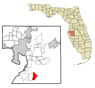
Wimauma is an unincorporated census-designated place in Hillsborough County, Florida, United States. The population was 6,373 at the 2010 census, up from 4,246 at the 2000 census.

<span class="mw-page-title-main">Manatee Road, Florida</span> Census-designated place in Florida, United States

Manatee Road is a census-designated place (CDP) in Levy County, Florida, United States. The population was 2,244 at the 2010 census. At the 2000 census, the CDP was misspelled as "Manattee Road".

<span class="mw-page-title-main">Bayshore Gardens, Florida</span> Census-designated place in Florida, United States

Bayshore Gardens is a census-designated place (CDP) and planned community in Manatee County, Florida, United States. The population was 19,904 at the 2020 census, up from 16,323 in 2010. It is part of the Bradenton-Sarasota-Venice, Florida Metropolitan Statistical Area.

<span class="mw-page-title-main">Memphis, Florida</span> Census-designated place in Florida, United States

Memphis is an unincorporated community and census-designated place (CDP) in Manatee County, Florida, United States. The population was 9,024 as of the 2020 census, up from 7,848 in 2010. It is part of the Bradenton–Sarasota–Venice Metropolitan Statistical Area.

<span class="mw-page-title-main">South Bradenton, Florida</span> Census-designated place in Florida, United States

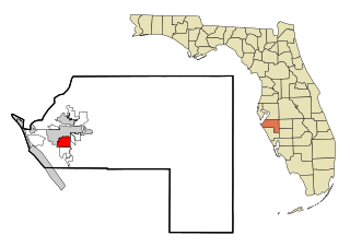
South Bradenton is an unincorporated community and census-designated place (CDP) in Manatee County, Florida, United States. The population was 26,858 at the 2020 census, up from 22,178 in 2010. It is part of the Bradenton–Sarasota–Venice Metropolitan Statistical Area.

<span class="mw-page-title-main">West Bradenton, Florida</span> Census-designated place in Florida, United States

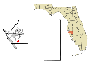
West Bradenton is an unincorporated area and census-designated place (CDP) in Manatee County, Florida, United States. The population was 4,247 at the 2020 census. It is part of the Bradenton–Sarasota–Venice Metropolitan Statistical Area.

<span class="mw-page-title-main">Whitfield, Manatee County, Florida</span> Census-designated place in Florida, United States

Whitfield, also known as Whitfield Estates, is an unincorporated community and census-designated place (CDP) in Manatee County, Florida, United States. As of the 2020 census it had a population of 2,989. It is part of the North Port–Sarasota–Bradenton Metropolitan Statistical Area. It receives its mail from the Sarasota post office located in Sarasota County.

<span class="mw-page-title-main">North River Shores, Florida</span> Census-designated place in Florida, United States

North River Shores is an unincorporated area and census-designated place (CDP) in Martin County, Florida, United States. The population was 3,459 at the 2020 census, up from 3,079 in 2010. It is part of the Port St. Lucie Metropolitan Statistical Area.

<span class="mw-page-title-main">Palm City, Florida</span> Census-designated place in Florida, United States

Palm City is an unincorporated area and census-designated place (CDP) in Martin County, Florida, United States. The population was 25,883 at the 2020 census. It is part of the Port St. Lucie Metropolitan Statistical Area.

<span class="mw-page-title-main">Rio, Florida</span> Census-designated place in Florida, United States

Rio is an unincorporated community and census-designated place (CDP) in Martin County, Florida, United States. The population was 980 at the 2020 census. Rio is pronounced locally as if it were spelled "Rye-oh". It is part of the Port St. Lucie Metropolitan Statistical Area.

<span class="mw-page-title-main">Fort Pierce North, Florida</span> CDP in Florida, United States

Fort Pierce North is a census-designated place (CDP) in St. Lucie County, Florida, United States. Per the 2020 census, the population was 6,904. It is part of the Port St. Lucie Metropolitan Statistical Area.

<span class="mw-page-title-main">Fort Pierce South, Florida</span> CDP in Florida, United States

Fort Pierce South is a census-designated place (CDP) in St. Lucie County, Florida, United States. The population was 5,062 at the 2010 census. It is part of the Port St. Lucie Metropolitan Statistical Area.

<span class="mw-page-title-main">Hutchinson Island South, Florida</span> CDP in Florida, United States

Hutchinson Island South is a census-designated place (CDP) on the barrier island of Hutchinson Island in St. Lucie County, Florida, United States. The South in its name refers to its location in the southern part of St. Lucie County, as it is actually in the central part of the island as a whole. The population was 4,846 at the 2000 census. It is part of the Port St. Lucie Metropolitan Statistical Area. Its mail is delivered from Jensen Beach 34957 in nearby Martin County. The Jensen Beach post office has a postal contract substation known as Hutchinson Beach located at 11007 South Ocean Drive, but it offers only post office boxes and counter services.

<span class="mw-page-title-main">Indian River Estates, Florida</span> CDP in Florida, United States

Indian River Estates is a census-designated place (CDP) in St. Lucie County, Florida, United States. The population was 6,220 at the 2010 census. It is part of the Port St. Lucie Metropolitan Statistical Area.

<span class="mw-page-title-main">Lakewood Park, Florida</span> Census-designated place in Florida, United States

Lakewood Park is a Census-designated place in St. Lucie County, Florida, United States. The population was 11,323 at the 2010 census. It is part of the Port St. Lucie Metropolitan Statistical Area.

<span class="mw-page-title-main">River Park, Florida</span> Census-designated place in Florida, United States

River Park is a census-designated place (CDP) in St. Lucie County, Florida, United States. The population was 5,222 at the 2010 census, at which time it was listed as Port St. Lucie-River Park. It is part of the Port St. Lucie Metropolitan Statistical Area.

<span class="mw-page-title-main">White City, St. Lucie County, Florida</span> CDP in Florida, United States

White City is a census-designated place (CDP) in St. Lucie County, Florida, United States. The population was 3,719 at the 2010 census. It is part of the Port St. Lucie Metropolitan Statistical Area.

<span class="mw-page-title-main">Rio Lucio, New Mexico</span> CDP in New Mexico, United States

Rio Lucio is a census-designated place (CDP) in Taos County, New Mexico, United States. The population was 379 at the 2000 census.

Iron Post is a census-designated place (CDP) in Mayes County, Oklahoma, United States. The population was 117 at the 2000 census, but had declined to 92 in 2010, a loss of more than 21 percent.

Lakewood Ranch is a planned community and census-designated place in southeastern Manatee County and northeastern Sarasota County, Florida, United States, consisting of approximately 31,000 acres (13,000 ha). It is part of the North Port-Bradenton-Sarasota, Florida Metropolitan Statistical Area.

References

  1. 1 2 "2022 U.S. Gazetteer Files: Florida". United States Census Bureau. Retrieved December 23, 2022.
  2. 1 2 "P1. Race – Port Salerno CDP, Florida: 2020 DEC Redistricting Data (PL 94-171)". U.S. Census Bureau. Retrieved December 23, 2022.
  3. 1 2 "U.S. Census website". United States Census Bureau . Retrieved January 31, 2008.
  4. "US Board on Geographic Names". United States Geological Survey. October 25, 2007. Retrieved January 31, 2008.
  5. "US Gazetteer files: 2010, 2000, and 1990". United States Census Bureau. February 12, 2011. Retrieved April 23, 2011.
  6. Luckhardt, Alice L. and Greg E., "Historical Vignettes: Salerno: Benjamin W. Mulford's Utopia", Treasure Coast Newspapers , TCPalm.com, Jun. 10, 2013. Retrieved June 22, 2015.
  7. Munden, Kenneth White, ed. American Film Institute Catalog: Feature Films 1961-1970. Univ. of Calif. Press, 1976, p. 392. ISBN   0-520-20970-2.
  8. Port Salerno World Fishing Tournaments
  9. "Census of Population and Housing". Census.gov. Retrieved June 4, 2016.
  10. "Explore Census Data". data.census.gov. Retrieved February 12, 2022.

Commons-logo.svg Media related to Port Salerno, Florida at Wikimedia Commons