Fort Pierce, Florida

Last updated

Fort Pierce, Florida
Fort Pierce Inlet State Park.jpg
Fort Pierce Inlet State Park
Seal of Fort Pierce, Florida.png
Nickname: 
The Sunrise City
St. Lucie County Florida Incorporated and Unincorporated areas Fort Pierce Highlighted.svg
Location in St. Lucie County and the state of Florida
Coordinates: 27°26′20″N80°20′8″W / 27.43889°N 80.33556°W / 27.43889; -80.33556
CountryFlag of the United States.svg United States
State Flag of Florida.svg Florida
County St. Lucie
Founded1838 [1]
Settled c. 1860s [1]
Incorporated (city) 1901 [2] [3]
Government
  Type Commission-Manager
   Mayor Linda Hudson
   Commissioners [4]
List
   City Manager Nicholas C. Mimms
   City Clerk Linda Cox [5]
   City Attorney Andrea Duenas [6]
Area
[7]
  Total29.84 sq mi (77.29 km2)
  Land23.79 sq mi (61.62 km2)
  Water6.05 sq mi (15.67 km2)
Elevation
16 ft (5 m)
Population
 (2020)
  Total47,297
  Density1,988.02/sq mi (767.59/km2)
Time zone UTC−5 (Eastern (EST))
  Summer (DST) UTC−4 (EDT)
ZIP Codes
34945–34951, 34954, 34979, 34981-34982
FIPS code 12-24300
GNIS feature ID0307964 [8]
Website cityoffortpierce.com

Fort Pierce is a city in and the county seat of St. Lucie County, Florida, United States. The city is part of the Treasure Coast region of Atlantic Coast Florida. [9] It is also known as the Sunrise City. [10] Per the 2020 census, the population was 47,297. [11]

Contents

History

The city was named after the Fort Pierce Army post which was built nearby in 1838 during the Second Seminole War, and lasted until 1842. [1] The military post had been named for Benjamin Kendrick Pierce, a career United States Army officer and the brother of President Franklin Pierce. [12]

The first permanent settlement of the current city was during the 1860s. [1] In 1901, the city was officially incorporated as a municipality. [2] [3] It was the largest city on Florida's Atlantic Coast between Daytona Beach and West Palm Beach until 1970, when it was surpassed by Melbourne.

Geography

Fort Pierce Marina Fort Pierce Marina.jpg
Fort Pierce Marina

According to the U.S. Census Bureau, the city has a total area of 20.8 mi2 (53.8 km2), of which 14.7 square miles (38.2 km2) is land and 6.0 square miles (15.6 km2) of it (35.00%) is water.

Environment

Shore Protection project

According to the U.S. Army Corps of Engineers, The Fort Pierce Beach Shore Protection project includes 1.3 miles of shore line running from immediately south of the Fort Pierce Inlet southward to Surfside Park. The project is on a two-year renourishment cycle due to impacts to the beach from the federal navigation project at Fort Pierce Inlet. This two-year renourishment cycle is a much shorter renourishment interval than what is typical for other projects along the east coast of Florida. [13]

The initial construction of the project occurred in 1971 and the ninth nourishment was completed in May 2013. Completion of plans and specifications, advertisement and award for the 10th renourishment contract were completed in FY 2014. The project was scheduled to start mid-February 2015. Sand for the project is dredged from an approved offshore borrow area known as the Capron Shoal and then pumped via a pipeline onto the 1.3 miles of beach south of the Fort Pierce Inlet. The sponsor, St. Lucie County, is preparing a General Reevaluation Report (GRR) for the project at their own expense that will evaluate extending Federal participation for an additional 50 years. Current Federal participation expires in 2020. [13]

The U.S. Army Corps of Engineers estimates the total cost of the project to be $75.9 million, with an estimated U.S. Federal Government share of $46.4 million. No funding for the project was requested by the U.S. President from the U.S. Congress in Fiscal Year 2016. [13]

Ecology

The Experimental Oculina Research Reserve preserves the Oculina Banks, a reef of ivory bush coral (Oculina varicosa) off the coast of Fort Pierce, Florida. In 1984, a 92 square-nautical-mile (316 km2) portion of these reefs was designated the "Oculina Habitat Area of Particular Concern". In 1994, the area was closed to all manner of bottom fishing and was redesignated as a research reserve. In 2000, the marine protected area was expanded to 300 square nautical miles (1,030 km2) and prohibited all gears that caused mechanical disruption to the habitat. The city is also known for its large manatee population.

Marina

Due to the devastation caused at the Fort Pierce City Marina by hurricanes Frances and Jeanne in 2004, FEMA mandated a plan to ensure that the rebuilt facility would be protected from future such events before FEMA would release funding for the repairs. Starting in 2012, construction began to create 12 artificial barrier islands including oyster beds, lime rock artificial reefs, mangrove fringes and coastal dune. The "core" of the islands was constructed of TITANTubes, sometimes referred to as geotextile tubes or geotubes, manufactured by Flint Industries and covered by a coastal marine mattress and then armor stone. The project was completed in 2013 after six years of planning, permitting and construction and a cost of $18 million.

Climate

Fort Pierce has a humid subtropical climate, with hot, humid summers and warm, drier winters.

Climate data for Fort Pierce, Florida (Treasure Coast International Airport), 1991–2020 normals, extremes 1901–present
MonthJanFebMarAprMayJunJulAugSepOctNovDecYear
Record high °F (°C)89
(32)
90
(32)
93
(34)
97
(36)
98
(37)
101
(38)
101
(38)
101
(38)
99
(37)
98
(37)
92
(33)
89
(32)
101
(38)
Mean maximum °F (°C)84.4
(29.1)
86.4
(30.2)
89.4
(31.9)
91.0
(32.8)
93.4
(34.1)
94.9
(34.9)
95.7
(35.4)
95.0
(35.0)
93.3
(34.1)
90.9
(32.7)
87.0
(30.6)
84.7
(29.3)
97.0
(36.1)
Mean daily maximum °F (°C)73.4
(23.0)
75.7
(24.3)
78.3
(25.7)
81.9
(27.7)
85.6
(29.8)
88.5
(31.4)
90.3
(32.4)
90.2
(32.3)
88.1
(31.2)
84.2
(29.0)
79.2
(26.2)
75.4
(24.1)
82.6
(28.1)
Daily mean °F (°C)62.3
(16.8)
64.8
(18.2)
67.4
(19.7)
71.5
(21.9)
76.2
(24.6)
79.9
(26.6)
81.4
(27.4)
81.6
(27.6)
80.3
(26.8)
76.4
(24.7)
69.9
(21.1)
65.5
(18.6)
73.1
(22.8)
Mean daily minimum °F (°C)51.2
(10.7)
53.9
(12.2)
56.5
(13.6)
61.1
(16.2)
66.8
(19.3)
71.3
(21.8)
72.6
(22.6)
72.9
(22.7)
72.6
(22.6)
68.5
(20.3)
60.6
(15.9)
55.7
(13.2)
63.6
(17.6)
Mean minimum °F (°C)34.0
(1.1)
37.0
(2.8)
41.3
(5.2)
47.6
(8.7)
56.7
(13.7)
66.5
(19.2)
68.7
(20.4)
69.2
(20.7)
67.2
(19.6)
53.9
(12.2)
44.7
(7.1)
38.1
(3.4)
31.8
(−0.1)
Record low °F (°C)19
(−7)
25
(−4)
26
(−3)
33
(1)
45
(7)
56
(13)
61
(16)
61
(16)
59
(15)
42
(6)
31
(−1)
19
(−7)
19
(−7)
Average precipitation inches (mm)2.82
(72)
2.17
(55)
2.88
(73)
3.03
(77)
3.93
(100)
6.69
(170)
5.85
(149)
6.94
(176)
6.27
(159)
5.25
(133)
3.01
(76)
2.33
(59)
51.17
(1,300)
Average precipitation days (≥ 0.01 in)8.77.78.17.29.014.215.315.415.412.210.49.3132.9
Source: NOAA [14] [15]

Demographics

Historical population
CensusPop.Note
1910 1,333
1920 2,11558.7%
1930 4,803127.1%
1940 8,04067.4%
1950 13,50267.9%
1960 25,25687.1%
1970 29,72117.7%
1980 33,80213.7%
1990 36,8309.0%
2000 37,5161.9%
2010 41,91011.7%
2020 47,29712.9%
U.S. Decennial Census [16]
2010 [17] 2020 [18]
Fort Pierce racial composition
(Hispanics excluded from racial categories)
(NH = Non-Hispanic)
RacePop 2010 [17] Pop 2020 [18] % 2010% 2020
White (NH)14,63915,46535.20%32.70%
Black or African American (NH)16,78717,93640.36%37.92%
Native American or Alaska Native (NH)107860.26%0.18%
Asian (NH)3374720.81%1.00%
Pacific Islander or Native Hawaiian (NH)20150.05%0.03%
Some other race (NH)832730.20%0.58%
Two or more races/Multiracial (NH)6131,4501.47%3.07%
Hispanic or Latino (any race)9,00411,60021.65%24.53%
Total41,59047,297100.00%100.00%

As of the 2020 United States census, there were 47,297 people, 16,687 households, and 10,005 families residing in the city. [19]

As of the 2010 United States census, there were 41,590 people, 15,207 households, and 9,515 families residing in the city. [20]

As of the census of 2010, the population density was 2,021.9 inhabitants per square mile (780.7/km2). [21] There were 17,170 housing units at an average density of 1,164.7 per square mile (449.7/km2).

In 2010, there were 15,207 households, out of which 32.9% had children under the age of 18 living with them, 37.3% were married couples living together, 19.6% had a female householder with no husband present, and 37.9% were non-families. 32.5% of all households were made up of individuals, and 11.7% had someone living alone who was 65 years of age or older. The average household size was 2.73 and the average family size was 3.50. [22]

In 2010, in the city, the population was spread out, with 25.9% under the age of 18, 7.0% from 20 to 24, 13.3% from 25 to 34, 13.0% from 45 to 54, 9.8% from 55 to 64 and 6.8% who were 65 years of age or older. [22] The median age was 35.2 years. For every 100 females, there were 97.4 males. For every 100 females age 18 and over, there were 94.9 males.

In 2010, the median income for a household in the city was $30,869, and the median income for a family was $36,337. Males had a median income of $32,412 versus $26,349 for females. [22] The per capita income for the city was $16,782. 30.2% of the population were below the poverty line. [21]

Economy

Fort Pierce Farmers Market Farmers Market in Fort Pierce Florida 5.jpg
Fort Pierce Farmers Market
Largest employers [23]
No.EmployerEmployees
1HCA Florida Lawnwood Hospital1,847
2Walmart Distribution Center1,273
3Pursuit Boats684
4Maverick Boat Group580
5City of Fort Pierce358

Port of Fort Pierce

According to the U.S. Army Corps of Engineers, an average of 350,000 tons of waterborne commerce moves through the Port of Fort Pierce annually. Major commodities which are dependent on the port include citrus exports, cement and aragonite imports. The last navigation improvements at Fort Pierce were authorized by the U.S. Congress in the Water Resources Development Act of 1988 dated November 17, 1988 and construction was completed in August 1996. The existing entrance channel is 400 feet wide and 30 feet deep, the interior channel is 250 feet wide and 28 feet deep, the existing turning basin is 1,100 feet square and 28 feet deep, and the north access channel is located immediately north of the main turning basin is 1,250 feet long, 250 feet wide and 28 feet deep. [24]

In late 2014 dredging efforts were completed in the port. The dredging effort included both beach placement of beach quality sand on the beach immediately south of the Inlet as well as placement of non beach quality sand in the approved offshore disposal area. [24]

Arts and culture

Tourist attractions

A.E. Backus Museum and Gallery Ft Pierce FL Backus Gallery-Museum01.jpg
A.E. Backus Museum and Gallery

Government

Fort Pierce City Hall City Hall (Fort Pierce, Florida).jpg
Fort Pierce City Hall

The city of Fort Pierce has a council–manager government form of local government. The offices of commissioner and mayor are nonpartisan, and have a term of four years.

Education

Colleges and Universities

Kight Center for Emerging Technologies at the Fort Pierce campus of Indian River State College Kight Center at IRSC Fort Pierce, Fl.jpg
Kight Center for Emerging Technologies at the Fort Pierce campus of Indian River State College

High Schools

Middle Schools

Elementary Schools

Infrastructure

Transportation

The Fort Pierce Railroad Station in the early 20th Century. Florida East Coast Railway station- Fort Pierce (5526146982).jpg
The Fort Pierce Railroad Station in the early 20th Century.

Fort Pierce is located on U.S. Route 1, near its intersection with Florida State Road 70. Interstate 95 and Florida's Turnpike are nearby, at the west edge of town. The Intracoastal Waterway passes through the city. The nearest airport with scheduled passenger service is in Melbourne; the closest major airport is in West Palm Beach. [35] The city itself has a general aviation airport, Treasure Coast International Airport.

Fort Pierce is served by the St. Lucie Transportation Planning Organization (TPO). [36] The TPO is a Metropolitan Planning Organization (MPO), a federally mandated and federally funded transportation policy-making organization responsible for transportation planning, programming, and financing of State and Federal transportation funds for the City of Fort Pierce. The TPO is governed by a TPO Board, which is composed of elected officials, representatives from the St. Lucie County School Board, and representatives from Community Transit, a division of The Council on Aging of St. Lucie, Inc. [37] The original bus system started as a demand response service bus in the 1990s; it only served St. Lucie County. Soon it expanded to a fixed route system, going to predetermined locations along a route. On June 3, 2002, the Florida Department of Transportation (FDOT) approved funding, expanding the bus service to Martin County, and it became the Treasure Coast Connector. [38] [39]

From 1894 to 1968 the Florida East Coast Railway served the city as a passenger railroad. Until a strike beginning in 1963, several long distance passenger trains from Chicago, Cincinnati and New York City made stops there, en route to Miami. These long distances trains included the Illinois Central Railroad's City of Miami and the Louisville & Nashville Railroad's South Wind both heading from Chicago; and they included the Atlantic Coast Line Railroad's East Coast Champion, the Havana Special, and the winter-only Florida Special originating from New York. [40] [41] [42] Into the latter 1950s, passengers could take the Dixie Flagler to Chicago via Atlanta from the station. [43] The FEC continued a six day a week Jacksonville-Miami train from 1965 to 1968, per court order. [44]

Amtrak and the Florida East Coast Railway had been planning to make stations along Florida's East Coast. The cities cited by Amtrak and the Florida Department of Transportation included: Stuart, Fort Pierce, Vero Beach, Melbourne, Titusville, Cocoa, Daytona Beach and St. Augustine, Florida. [45]

In 2023, Brightline, an inter-city rail route that currently runs between Miami and Orlando, announced that it was looking for sites for a new station on the Treasure Coast. [46] As of 2024, there are currently no plans to add a station in Fort Pierce.

Notable people

Zora Neale Hurston's house ZoraNealeHurstonHouse.jpg
Zora Neale Hurston's house

Actors

Businesspeople

Writers and artists

Musicians

Politicians

Activists

Sports

Other

Related Research Articles

<span class="mw-page-title-main">Indian River County, Florida</span> County in Florida, United States

Indian River County is a county located in the southeastern and east-central portions of the U.S. state of Florida. As of the 2020 census, the population was 159,788. Its seat is Vero Beach. It is Florida's 7th richest county and in 2000 was the 87th richest county in the U.S. by per capita income.

<span class="mw-page-title-main">Martin County, Florida</span> County in Florida, United States

Martin County is a county located in the southeastern part of the state of Florida, in the United States. As of the 2020 census, the population was 158,431. Its county seat is Stuart. Martin County is in the Port St. Lucie, FL Metropolitan Statistical Area.

<span class="mw-page-title-main">St. Lucie County, Florida</span> County in Florida, United States

St. Lucie County is located in the southeastern portion of the U.S. state of Florida. As of the 2020 census, the population was 329,226. The county's seat is Fort Pierce, while the largest city is Port St. Lucie, making up 62% of the county's population. St. Lucie County is the principal county of the Port St. Lucie, FL Metropolitan Statistical Area.

<span class="mw-page-title-main">Satellite Beach, Florida</span> City in Florida, U.S.

Satellite Beach is a coastal city in Brevard County, Florida, U.S. The population was 11,346 at the 2020 United States Census, and it is located with the Atlantic Ocean to the east and the Banana River to the west.

<span class="mw-page-title-main">Sebastian, Florida</span> City in Florida, United States

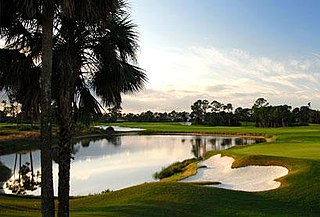
Sebastian is a city in Indian River County, Florida, United States at the confluence of the St. Sebastian River and the Indian River. It is two miles away from the Atlantic Ocean. It is the largest city in Indian River County and the biggest population center between Palm Bay and Fort Pierce. The city's economy is heavily reliant on tourism. It has numerous resorts in the local area, such as Disney's Vero Beach Resort. It is very close to many natural and scenic areas like the Pelican Island National Wildlife Refuge, Sebastian Inlet State Park, and St. Sebastian River Preserve State Park.

<span class="mw-page-title-main">Vero Beach, Florida</span> City in Florida, United States

Vero Beach is a city in and the county seat of Indian River County, Florida, United States. According to the 2020 census, the city had a population of 16,354. Nicknamed “The Gateway to the Tropics”, the city is situated along the Indian River Lagoon and the Atlantic Ocean on Florida's Treasure Coast. Located at the northern end of the South Florida region, Vero Beach is 85 miles (137 km) southeast of Orlando and 65 miles (105 km) north of West Palm Beach.

<span class="mw-page-title-main">Hobe Sound, Florida</span> Census-designated place in Florida, United States

Hobe Sound is an unincorporated area and census-designated place (CDP) in Martin County, Florida, United States, located along Florida's Treasure Coast. The population was 13,163 at the 2020 census, up from 11,521 in 2010.

<span class="mw-page-title-main">Stuart, Florida</span> City in Florida, United States

Stuart is a city in and the county seat of Martin County, Florida, United States. Located in southeastern Florida, Stuart is the largest of five incorporated municipalities in Martin County. The population is 17,425 according to the 2020 U.S. census. Stuart is the 126th largest city in Florida based on official 2019 estimates from the U.S. Census Bureau. It is part of the Port St. Lucie, Florida Metropolitan Statistical Area.

<span class="mw-page-title-main">Port St. Lucie, Florida</span> City in Florida, United States

Port St. Lucie is a city in St. Lucie County, Florida, United States. It is the most populous municipality in the county and the seventh-most populous city in Florida with a population of 204,851 at the 2020 census. It is located 125 miles (201 km) southeast of Orlando and 113 miles (182 km) north of Miami. It is a principal city in the Port St. Lucie Metropolitan Statistical Area, which includes St. Lucie and Martin counties, and as of 2021 had an estimated population of 502,521. Port St. Lucie is also a principal city in the Miami-Fort Lauderdale-Port St. Lucie Combined Statistical Area, which had an estimated population of 6,841,100 as of 2021.

<span class="mw-page-title-main">Miami metropolitan area</span> Metropolis in the U.S. state of Florida

The Miami metropolitan area, also known as South Florida, SoFlo, SoFla, the Gold Coast, the Tri-County Area, or Greater Miami, and officially the Miami–Fort Lauderdale–West Palm Beach Metropolitan Statistical Area, is a coastal metropolitan area in southeastern Florida. It is the ninth-largest metropolitan statistical area (MSA) in the United States, the fifth-largest metropolitan area in the Southern United States, and the largest metropolitan area in Florida. With a population of 6.18 million, its population exceeds 31 of the nation's 50 states as of 2023. It comprises the three most populated counties in the state, Miami-Dade County, Broward County, and Palm Beach County, which rank as the first, second, and third-most populous counties in the state, respectively. Miami-Dade County, with 2,701,767 people in 2020, is the seventh-most populous county in the United States.

<span class="mw-page-title-main">Treasure Coast</span> Region in Florida

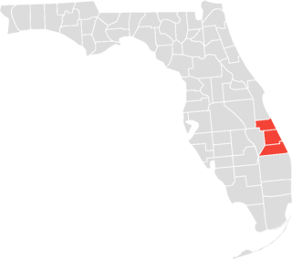
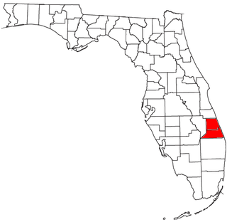
The Treasure Coast is a region in the southeast of the U.S. state of Florida. It borders the Atlantic Ocean and comprises Indian River, Martin, and St. Lucie counties. The region, whose name refers to the Spanish Treasure Fleet that was lost in a 1715 hurricane, evidently emerged from residents' desire to distinguish themselves from the Gold Coast to the south.

<span class="mw-page-title-main">St. Lucie Inlet, Florida</span> Ocean inlet in Florida, US

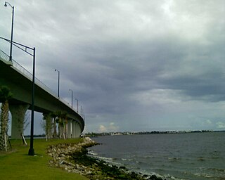
The St. Lucie Inlet, Florida is located between Hutchinson Island and Jupiter Island in Martin County, Florida, at coordinates 27°09′58″N80°09′24″W. The St. Lucie Inlet is one of six inlets into the Indian River Lagoon.

<span class="mw-page-title-main">County Road 707 (Treasure Coast)</span> Two segments of road in Florida, US

County Road 707 (CR 707) is a designation applied to two segments of road across three counties on Florida's Treasure Coast. The entire road was formerly designated State Road 707 (SR 707) and has been gradually transferred to county jurisdiction.

<span class="mw-page-title-main">Interstate 95 in Florida</span> Highway in Florida

Interstate 95 (I-95) is the main Interstate Highway of Florida's Atlantic Coast. It begins at a partial interchange with US Highway 1 (US 1) just south of downtown Miami and heads north through Jacksonville, and to the Georgia state line at the St. Marys River near Becker. The route also passes through the cities of Fort Lauderdale, West Palm Beach, Port St. Lucie, Titusville, and Daytona Beach.

TCPalm is the digital news site for Treasure Coast Newspapers, the largest daily news operation on the Treasure Coast of southeastern Florida. The region encompasses three coastal counties: Martin County, St. Lucie County and Indian River County. Treasure Coast Newspapers publishes three daily print newspapers: The Stuart News, St. Lucie News Tribune and the Indian River Press Journal, as well as the weekly Luminaries. The site was launched by Scripps Howard newspapers in 1996, and has been owned by Gannett since 2016.

<span class="mw-page-title-main">U.S. Route 1 in Florida</span> Highway in Florida

U.S. Highway 1 (US 1) in Florida runs 545 miles (877 km) along the state's east coast from Key West to its crossing of the St. Marys River into Georgia north of Boulogne and south of Folkston. US 1 was designated through Florida when the U.S. Numbered Highway System was established in 1926. With the exception of Monroe County, the highway runs through the easternmost tier of counties in the state, connecting numerous towns and cities along its route, including nine county seats. The road is maintained by the Florida Department of Transportation (FDOT).

<span class="mw-page-title-main">Florida's 21st congressional district</span> U.S. House district for Florida

Florida's 21st congressional district is a U.S. congressional district on the Treasure Coast. In the 2020 redistricting cycle, the district was drawn as a successor to the previous 18th district and contains all of St. Lucie County and Martin County as well as the northeastern part of Palm Beach County, and includes Port St. Lucie, Fort Pierce, Stuart, Jupiter, and Palm Beach Gardens, as well as Treasure Coast International Airport. The previous iteration of the 21st district, which extended from Delray Beach to Palm Beach, was instead renamed the 22nd district.

<span class="mw-page-title-main">Florida's 18th congressional district</span> U.S. House district for Florida

Florida's 18th congressional district is an electoral district for the U.S. Congress, located in the Florida Heartland. In the 2020 redistricting cycle, the district was created as a new district, which includes the inland counties of DeSoto, Glades, Hardee, Hendry, Highlands, and Okeechobee, as well as most of Polk County and some of Immokalee in Collier County. The previous 18th district, located in the Treasure Coast, was instead renamed the 21st district.

<span class="mw-page-title-main">North Hutchinson Island</span>

North Hutchinson Island is a coastal barrier island in Indian River and St. Lucie counties on the east coast of Florida in the United States. The island is adjacent to the Atlantic Ocean and is separated from the mainland on the west by the Indian River Lagoon. The portion of the island in Indian River County is known as Orchid Island.

<span class="mw-page-title-main">Port St. Lucie metropolitan area</span> Statistical area in Florida, US

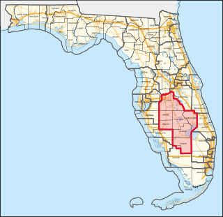
The Port St. Lucie, FL Metropolitan Statistical Area (MSA) includes St. Lucie and Martin counties in the Treasure Coast region of Florida.

References

  1. 1 2 3 4 "Geography & Travel - Fort Pierce Florida, United States". Britannica .
  2. 1 2 "ABOUT FORT PIERCE". cityoffortpierce.com.
  3. 1 2 "FLORIDA CITIES BY INCORPORATION YEAR WITH INCORPORATION & DISSOLUTION INFO" (PDF). flcities.com.
  4. "Mayor & City Commission". City of Fort Pierce. Retrieved March 31, 2024.
  5. "City Clerk". City of Fort Pierce.
  6. "Member Profile". Florida Bar.
  7. "2020 U.S. Gazetteer Files". United States Census Bureau. Retrieved October 31, 2021.
  8. "US Board on Geographic Names". United States Geological Survey. October 25, 2007. Retrieved January 31, 2008.
  9. "Find a County". National Association of Counties. Archived from the original on May 31, 2011. Retrieved June 7, 2011.
  10. Jernigan, Meg. "Things to Do in Fort Pierce, Florida". USA Today. Retrieved February 12, 2024.
  11. "Fort Pierce city, Florida". United States Census Bureau . Retrieved April 15, 2022.
  12. Wilson, Jean Ellen (2014). Legendary Locals of Fort Pierce. Arcadia Publishing. p. 7. ISBN   9781467101271 . Retrieved September 17, 2014.
  13. 1 2 3 "U.S. Army Corps of Engineers -- Congressional Fact Sheet -- Fort Pierce Beach FL, Shore Protection Project" (PDF).
  14. "NOWData - NOAA Online Weather Data". National Oceanic and Atmospheric Administration . Retrieved May 24, 2021.
  15. "Summary of Monthly Normals 19912020". National Oceanic and Atmospheric Administration . Retrieved May 24, 2021.
  16. "Decennial Census of Population and Housing by Decades". US Census Bureau.
  17. 1 2 "P2 HISPANIC OR LATINO, AND NOT HISPANIC OR LATINO BY RACE – 2010: DEC Redistricting Data (PL 94-171) – Fort Pierce city, Florida". United States Census Bureau .
  18. 1 2 "P2 HISPANIC OR LATINO, AND NOT HISPANIC OR LATINO BY RACE – 2020: DEC Redistricting Data (PL 94-171) – Fort Pierce city, Florida". United States Census Bureau .
  19. "S1101 HOUSEHOLDS AND FAMILIES - 2020: Fort Pierce city, Florida". United States Census Bureau .
  20. "S1101 HOUSEHOLDS AND FAMILIES - 2010: Fort Pierce city, Florida". United States Census Bureau .
  21. 1 2 "Fort Pierce (city) QuickFacts from the US Census Bureau". census.gov. Archived from the original on November 18, 2015. Retrieved November 16, 2015.
  22. 1 2 3 Data Access and Dissemination Systems (DADS). "U.S. Census website". census.gov. Retrieved November 16, 2015.
  23. Major Employers, St. Lucie EDC.
  24. 1 2 "U.S. Army Corps of Engineers -- Congressional Fact Sheet -- Fort Pierce Harbor" (PDF).
  25. "Art Mundo".
  26. 1 2 Archived August 1, 2015, at the Wayback Machine
  27. "St. Lucie County". Archived from the original on October 4, 2013.
  28. "Main Street Fort Pierce" . Retrieved August 8, 2013.
  29. "Fort Pierce Tourist Attractions". PlanetWare. Archived from the original on February 16, 2011. Retrieved August 8, 2013.
  30. "Manatee Observation and Education Center". Manateecenter.com. Retrieved August 8, 2013.
  31. "Smithsonian Marine Ecosystems Exhibit: Smithsonian Marine Station (SMS) at Fort Pierce". Sms.si.edu. February 6, 2007. Retrieved August 8, 2013.
  32. "St Lucie County Florida Online || St. Lucie County Marine Center". Stlucieco.gov. Archived from the original on August 9, 2013. Retrieved August 8, 2013.
  33. "St Lucie County Florida Online || Regional History Center". Stlucieco.gov. Retrieved August 8, 2013.
  34. "Sunrise Theatre".
  35. Rand McNally Road Atlas, 2016.
  36. "Transportation Planning Organization - Homepage". Stlucietpo.org. February 2, 2011. Retrieved August 8, 2013.
  37. "Our Services > Transportation". COASL. Retrieved August 8, 2013.
  38. "Home". Treasure Coast Connector. Retrieved August 8, 2013.
  39. "Treasure Coast Connector: Services". treasurecoastconnector.com. Retrieved November 16, 2015.
  40. "Florida East Coast Railway". Official Guide of the Railways. 90 (7). National Railway Publication Company. December 1957.
  41. "Florida East Coast Railway". Official Guide of the Railways. 91 (3). National Railway Publication Company. January 1962.
  42. Bramson, Seth H. Speedway to Sunshine: the story of the Florida East Coast Railway, Boston Mills Press, 2010, p. 227. ISBN   9781554077533.
  43. Herr, Kincaid A. University Press of Kentucky, 1964, p. 273.
  44. Bramson, Seth H. Speedway to Sunshine: the story of the Florida East Coast Railway, Boston Mills Press, 2010, pp. 151, 153. ISBN   9781554077533.
  45. "Orlando Sun-Sentinel," Feb 22, 2013, Angel Streeter, "Amtrak still hopeful for service on FEC tracks" http://articles.sun-sentinel.com/2013-02-22/news/fl-amtrak-florida-east-coast-railroad-20130215_1_amtrak-service-fec-passenger-service Archived 2018-01-29 at the Wayback Machine
  46. "BRIGHTLINE ANNOUNCES PROCESS TO SELECT A TREASURE COAST STATION". www.gobrightline.com. October 26, 2023. Retrieved January 6, 2024.
  47. "Edwin Binney" Retrieved on 2009-03-12
  48. "A.E. Backus Museum". Archived from the original on February 14, 2014. Retrieved October 2, 2013.
  49. "Zora Neale Hurston".
  50. Gary Stewart (singer)
  51. "Florida Governor Daniel Thomas McCarty". National Governors Association. Retrieved December 10, 2012.
  52. "Judge Sturtevant Dies in Florida" . Burlington Free Press. Burlington, VT. September 17, 1966. p. 7 via Newspapers.com.
  53. "Jeffrey Leon Blackshear". Pro-Football-Reference.Com. Retrieved December 10, 2012.
  54. "Jeffrey Leon Blackshear". Pro-Football-Reference.Com. Retrieved December 10, 2012.
  55. "Yamon Figurs". Pro-Football-Reference.Com. Retrieved December 10, 2012.
  56. "Charles Johnson Stats". Baseball Almanac. Retrieved December 10, 2012.
  57. "Terry McGriff Stats". Baseball Almanac. Retrieved December 10, 2012.
  58. "Ryan Darrell McNeil". Pro-Football-Reference.Com. Retrieved December 10, 2012.
  59. "Wonder Monds". Pro-Football-Reference.Com. Retrieved April 14, 2014.
  60. "Luther Robinson". hurricanesports.com. Retrieved October 2, 2014.
  61. "Larry Sandersl". Basketball-Reference.Com. Retrieved December 10, 2012.
  62. "Jeff Schwarz Stats". Baseball Almanac. Retrieved December 10, 2012.
  63. Graffis, Herb (October 1944). "Making The Swing" (PDF). Golfdom: 5–6.
  64. Bidney, Beverly (December 31, 2014). "Louise Gopher bestowed with FSU honorary degree" (PDF). Seminole Tribune. Archived from the original (PDF) on March 17, 2015. Retrieved May 23, 2016.
  65. Fox, Margalit. "John Houghtaling, Inventor of Magic Fingers Vibrating Bed, Dies at 92", The New York Times , June 19, 2009. Accessed June 20, 2009.
  66. "United Hero: CeeCee Ross-Lyles".