Taylor County | |
---|---|
Coordinates: 30°01′N83°37′W / 30.02°N 83.62°W | |
Country | United States |
State | Florida |
Founded | December 23, 1856 |
Named for | Zachary Taylor |
Seat | Perry |
Largest city | Perry |
Area | |
• Total | 1,232 sq mi (3,190 km2) |
• Land | 1,043 sq mi (2,700 km2) |
• Water | 189 sq mi (490 km2) 15.3% |
Population (2020) | |
• Total | 21,796 |
• Density | 21/sq mi (8/km2) |
Time zone | UTC−5 (Eastern) |
• Summer (DST) | UTC−4 (EDT) |
Congressional district | 2nd |
Website | www |
Taylor County is a county located in the Big Bend region in the northern part of the U.S. state of Florida. As of the 2020 census, the population was 21,796. [1] Its county seat is Perry. [2] The county hosts the annual Florida Forest Festival and has been long known as the "Tree Capital of the South" since a 1965 designation from then-Governor W. Haydon Burns. [3]
Taylor County was created on December 23, 1856, from Madison County. It was named for Zachary Taylor, twelfth president of the United States, who served from 1849 to 1850. Taylor won most counties in northern Florida during the election of 1848 and was largely responsible for the ultimate U.S. victory in the Second Seminole War. [4]
During the American Civil War, Taylor County was home to William Strickland and his band of deserters and Unionists called "The Royal Rangers" or the "Independent Rangers". [5] In 1864, a Confederate colonel tasked with hunting down deserters, broke into Strickland's home and found a membership list of 35 men who "bear true allegiance to the United States of America." Despite their names being identified and homes burned to the ground, few members of the Rangers surrendered. [6]
According to the U.S. Census Bureau, the county has a total area of 1,232 square miles (3,190 km2), of which 1,043 square miles (2,700 km2) is land and 189 square miles (490 km2) (15.3%) is water. [7]
Census | Pop. | Note | %± |
---|---|---|---|
1860 | 1,384 | — | |
1870 | 1,453 | 5.0% | |
1880 | 2,279 | 56.8% | |
1890 | 2,122 | −6.9% | |
1900 | 3,999 | 88.5% | |
1910 | 7,103 | 77.6% | |
1920 | 11,219 | 57.9% | |
1930 | 13,136 | 17.1% | |
1940 | 11,565 | −12.0% | |
1950 | 10,416 | −9.9% | |
1960 | 13,168 | 26.4% | |
1970 | 13,641 | 3.6% | |
1980 | 16,532 | 21.2% | |
1990 | 17,111 | 3.5% | |
2000 | 19,256 | 12.5% | |
2010 | 22,570 | 17.2% | |
2020 | 21,796 | −3.4% | |
2023 (est.) | 21,582 | [8] | −1.0% |
U.S. Decennial Census [9] 1790-1960 [10] 1900-1990 [11] 1990-2000 [12] 2010-2019 [13] |
Note: the US Census treats Hispanic/Latino as an ethnic category. This table excludes Latinos from the racial categories and assigns them to a separate category. Hispanics/Latinos can be of any race.
Race | Pop 2010 | Pop 2020 | % 2010 | % 2020 |
---|---|---|---|---|
White (NH) | 16,483 | 15,629 | 73.03% | 71.71% |
Black or African American (NH) | 4,629 | 4,196 | 20.51% | 19.25% |
Native American or Alaska Native (NH) | 171 | 102 | 0.76% | 0.47% |
Asian (NH) | 149 | 224 | 0.66% | 1.03% |
Pacific Islander (NH) | 5 | 0 | 0.02% | 0.0% |
Some Other Race (NH) | 15 | 45 | 0.07% | 0.21% |
Mixed/Multi-Racial (NH) | 341 | 734 | 1.51% | 3.37% |
Hispanic or Latino | 777 | 866 | 3.44% | 3.97% |
Total | 22,570 | 21,796 |
As of the 2020 United States census, there were 21,796 people, 7,405 households, and 5,197 families residing in the county.
As of the census [16] of 2000, there were 19,256 people, 7,176 households, and 5,130 families residing in the county. The population density was 18 people per square mile (6.9 people/km2). There were 9,646 housing units at an average density of 9 per square mile (3.5/km2). The racial makeup of the county was 77.84% White, 19.04% Black or African American, 0.98% Native American, 0.44% Asian, 0.02% Pacific Islander, 0.32% from other races, and 1.38% from two or more races. 1.53% of the population were Hispanic or Latino of any race.
There were 7,176 households, out of which 31.60% had children under the age of 18 living with them, 52.50% were married couples living together, 14.40% had a female householder with no husband present, and 28.50% were non-families. 24.20% of all households were made up of individuals, and 10.60% had someone living alone who was 65 years of age or older. The average household size was 2.51 and the average family size was 2.95.
In the county, the population was spread out, with 24.60% under the age of 18, 8.20% from 18 to 24, 28.30% from 25 to 44, 24.80% from 45 to 64, and 14.10% who were 65 years of age or older. The median age was 38 years. For every 100 females there were 104.40 males. For every 100 females age 18 and over, there were 104.80 males.
The median income for a household in the county was $30,032, and the median income for a family was $35,061. Males had a median income of $27,967 versus $19,054 for females. The per capita income for the county was $15,281. About 14.50% of families and 18.00% of the population were below the poverty line, including 22.20% of those under age 18 and 17.90% of those age 65 or over.
In March 2016, the county's unemployment rate was 5.6%.
Students are served by the Taylor County School System. For the 2006 - 2007 school year the Florida Department of Education gave the District a "B" grade with three of its schools earning an "A" and one school earning a "B" grade. [17]
Taylor County High School also has an Army JROTC unit which has been an Honor Unit with Distinction for 27 consecutive years. [18]
The Taylor County Public Library is part of the Three Rivers Library System, which also serves Gilchrist, Lafayette, and Dixie counties. [19]
Taylor County was a Democratic-leaning county until 1964, when Republican Barry Goldwater carried it. Democrats only carried the county three times since then, with the last being in 1996.
Year | Republican | Democratic | Third party | |||
---|---|---|---|---|---|---|
No. | % | No. | % | No. | % | |
2020 | 7,751 | 76.45% | 2,299 | 22.68% | 88 | 0.87% |
2016 | 6,930 | 74.13% | 2,152 | 23.02% | 266 | 2.85% |
2012 | 6,249 | 68.37% | 2,764 | 30.24% | 127 | 1.39% |
2008 | 6,457 | 68.79% | 2,803 | 29.86% | 127 | 1.35% |
2004 | 5,467 | 63.71% | 3,049 | 35.53% | 65 | 0.76% |
2000 | 4,058 | 59.59% | 2,649 | 38.90% | 103 | 1.51% |
1996 | 3,188 | 39.86% | 3,583 | 44.80% | 1,226 | 15.33% |
1992 | 2,693 | 37.34% | 2,568 | 35.60% | 1,952 | 27.06% |
1988 | 4,057 | 69.06% | 1,763 | 30.01% | 55 | 0.94% |
1984 | 4,038 | 69.98% | 1,732 | 30.02% | 0 | 0.00% |
1980 | 2,776 | 47.31% | 2,963 | 50.49% | 129 | 2.20% |
1976 | 1,983 | 36.68% | 3,370 | 62.34% | 53 | 0.98% |
1972 | 4,109 | 84.50% | 754 | 15.50% | 0 | 0.00% |
1968 | 794 | 15.71% | 941 | 18.62% | 3,318 | 65.66% |
1964 | 2,661 | 60.91% | 1,708 | 39.09% | 0 | 0.00% |
1960 | 1,212 | 38.85% | 1,908 | 61.15% | 0 | 0.00% |
1956 | 776 | 28.52% | 1,945 | 71.48% | 0 | 0.00% |
1952 | 744 | 29.40% | 1,787 | 70.60% | 0 | 0.00% |
1948 | 216 | 10.81% | 1,354 | 67.73% | 429 | 21.46% |
1944 | 165 | 8.28% | 1,828 | 91.72% | 0 | 0.00% |
1940 | 198 | 7.34% | 2,499 | 92.66% | 0 | 0.00% |
1936 | 127 | 6.27% | 1,897 | 93.73% | 0 | 0.00% |
1932 | 130 | 8.24% | 1,447 | 91.76% | 0 | 0.00% |
1928 | 465 | 38.05% | 739 | 60.47% | 18 | 1.47% |
1924 | 100 | 16.45% | 476 | 78.29% | 32 | 5.26% |
1920 | 128 | 17.73% | 563 | 77.98% | 31 | 4.29% |
1916 | 51 | 8.36% | 547 | 89.67% | 12 | 1.97% |
1912 | 56 | 15.43% | 236 | 65.01% | 71 | 19.56% |
1908 | 160 | 31.13% | 250 | 48.64% | 104 | 20.23% |
1904 | 119 | 37.54% | 168 | 53.00% | 30 | 9.46% |
Baker County is a county in the U.S. state of Florida. As of the 2020 census, the population was 28,259. Its county seat is Macclenny. The county was founded in 1861 and is named for James McNair Baker, a judge and Confederate Senator.
Columbia County is a county located in the north central portion of the U.S. state of Florida. As of the 2020 census, the population was 69,698, up from 67,531 at the 2010 census. Its county seat is Lake City.
Dixie County is a county located in the Big Bend region of the northern part of the U.S. state of Florida. As of the 2020 census, the population was 16,759. Its county seat is Cross City.
Gilchrist County is a county located in the north central part of the U.S. state of Florida. Organized in 1925 from the western part of Alachua, it is the last county to be formed in the state. As of the 2020 census, the population was 17,864. The county seat is Trenton.
Hamilton County is a county located in the north central portion of the U.S. state of Florida. As of the 2020 census, the population was 14,004, down from 14,799 at the 2010 census. Its county seat is Jasper.
Lafayette County is a county located in the north central portion of the state of Florida. As of the 2020 census, the population was 8,226, making it the second-least populous county in Florida. The county seat is Mayo. Lafayette County is a prohibition or partially dry county, allowing retail sales of beer.
Liberty County is a county located in the state of Florida. As of the 2020 census, the population was 7,974, making it the least populous county in Florida. Its county seat is Bristol. Liberty County is the only dry county in Florida. Lafayette County prohibits bars, but not retail sale of beer.
Madison County is a county located in the north central portion of the state of Florida, and borders the state of Georgia to the north. As of the 2020 census, the population was 17,968. Its county seat is also called Madison.
Okeechobee County is a county located in the Florida Heartland region of the state of Florida. As of the 2020 census, the population was 39,644. The county seat is Okeechobee.
Suwannee County is a county located in the north central portion of the state of Florida. As of the 2020 census, the population was 43,474, up from 41,551 in 2010. Its county seat is Live Oak. Suwannee County was a dry county until August 2011, when the sale of alcoholic beverages became legal in the county.
Union County is a county located in the north central portion of the U.S. state of Florida, the smallest in the state by area. As of the 2020 census, the population was 16,147. The county seat is Lake Butler. With a personal per capita income of $18,396, it is the poorest county in the United States.
Lafayette County is a county in the western portion of Missouri, part of the Kansas City metropolitan area. As of the 2020 census, the population was 32,984. Its county seat is Lexington. The county was organized November 16, 1820, from Cooper County and originally named Lillard County for James Lillard of Tennessee, who served in the first state constitutional convention and first state legislature. It was renamed Lafayette County on February 16, 1825, in honor of Revolutionary War hero the Marquis de La Fayette, who was then visiting the United States.
Lafayette County is a county in the U.S. state of Mississippi. At the 2020 census, the population was 55,813. Its county seat is Oxford. The local pronunciation of the name is "la-FAY-et." The county's name honors Marquis de Lafayette, a French military hero and American general who fought during the American Revolutionary War.
Bradley is a city in Lafayette County, Arkansas, United States. The population was 628 at the 2010 census.
Cross City is a town and the county seat of Dixie County, Florida, United States. The population was 1,689 at the 2020 census.
Jennings is a town in Hamilton County, Florida, United States. The population was 749 at the 2020 census, down from 878 at the 2010 census.
Mayo, Florida is a town and the only municipality in Lafayette County, Florida, United States. It is the county seat of Lafayette County. The population was 1,055 at the 2020 census.
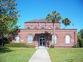
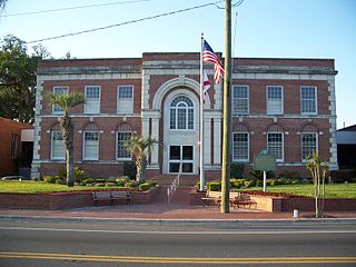
Madison is a city in and the county seat of Madison County, on the central northern border of Florida, United States. The population was 2,912 at the 2020 census.
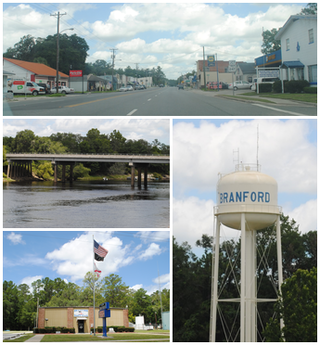
Branford is a town in Suwannee County, Florida, United States. The Town of Branford was officially incorporated as a municipality in 1961, although it has been settled since 1886. The population was 711 at the 2020 census.
Perry is a city and the county seat of Taylor County, Florida, United States. As of 2020, the population recorded by the U.S. Census Bureau was 6,898. The city was named for Madison Perry, fourth governor of the state of Florida and a Confederate colonel during the American Civil War.