
Indian River County is a county located in the southeastern and east-central portions of the U.S. state of Florida. As of the 2020 census, the population was 159,788. Its seat is Vero Beach. It is Florida's 7th richest county and in 2000 was the 87th richest county in the U.S. by per capita income.

Orange County is a county located in Central Florida, and as of the 2020 census, its population was 1,429,908 making it Florida's fifth-most populous county. Its county seat is Orlando, the core of the Orlando metropolitan area, which had a population of 2.67 million in 2020.

Osceola County is a county located in the central portion of the U.S. state of Florida. As of the 2020 census, the population was 388,656. Its county seat is Kissimmee. Osceola County is included in the Orlando–Kissimmee–Sanford, Fla. Metropolitan Statistical Area.

St. Lucie County is located in the southeastern portion of the U.S. state of Florida. As of the 2020 census, the population was 329,226. The county's seat is Fort Pierce, while the largest city is Port St. Lucie, making up 62% of the county's population. St. Lucie County is the principal county of the Port St. Lucie, FL Metropolitan Statistical Area.

Seminole County is a county located in the central portion of the U.S. state of Florida. As of the 2020 census, the population was 470,856, making it the 13th-most populated county in Florida. Its county seat and largest city is Sanford. Seminole County is part of the Orlando-Kissimmee-Sanford, Florida Metropolitan Statistical Area.
Volusia County is located in the east-central part of the U.S. state of Florida between the St. Johns River and the Atlantic Ocean. As of the 2020 census, the county was home to 553,543 people, an increase of 11.9% from the 2010 census. It was founded on December 29, 1854, from part of Orange County, and was named for the community of Volusia, located in northwestern Volusia County. Its first county seat was Enterprise. Since 1887, its county seat has been DeLand.

Hobe Sound is an unincorporated area and census-designated place (CDP) in Martin County, Florida, United States, located along Florida's Treasure Coast. The population was 13,163 at the 2020 census, up from 11,521 in 2010.
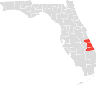
The Treasure Coast is a region in the southeast of the U.S. state of Florida. It borders the Atlantic Ocean and comprises Indian River, Martin, and St. Lucie counties. The region, whose name refers to the Spanish Treasure Fleet that was lost in a 1715 hurricane, evidently emerged from residents' desire to distinguish themselves from the Gold Coast to the south.
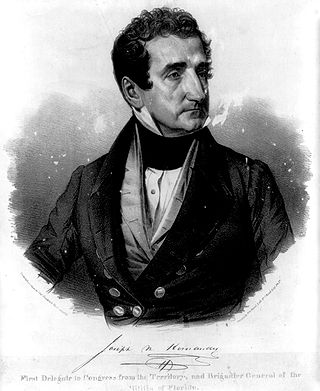
Joseph Marion Hernández was a slave-owning American planter, politician and military officer. He was the first delegate from the Florida Territory and the first Hispanic American to serve in the United States Congress. A member of the Democratic-Republican Party, he served from September 1822 to March 1823.

The Canaveral National Seashore (CANA) is a National Seashore located between New Smyrna Beach and Titusville, Florida, in Volusia and Brevard Counties. The park, located on a barrier island, was created on January 3, 1975, by an act of Congress. The park is split between Brevard and Volusia counties, with 9 miles of the seashore in Brevard County, and 15 miles of the seashore in Volusia County. CANA consists of 24 miles of beaches, dunes, mangrove wetlands, and a large portion of the Mosquito Lagoon. The Canaveral National Seashore is also the longest expanse of undeveloped land along the East Coast of Florida. The Canaveral National Seashore is home to more than 1,000 plant species and 310 bird species. CANA occupies 57,662 acres (23,335 ha). There are 3 major beach sections in the seashore. The southern section is Playalinda Beach, the middle section is Klondike Beach, and the northern section is Apollo Beach.

Enterprise is an unincorporated community in Volusia County, in the U.S. state of Florida, and its former county seat. Situated on the northern shore of Lake Monroe, it is flanked by the cities of DeBary and Deltona. Enterprise was once the head of navigation on the St. Johns River and at various times, the county seat for three different counties: Mosquito, which was renamed as Orange; and lastly, for Volusia, which was formed from part of Orange County.

U.S. Highway 1 (US 1) in Florida runs 545 miles (877 km) along the state's east coast from Key West to its crossing of the St. Marys River into Georgia north of Boulogne and south of Folkston. US 1 was designated through Florida when the U.S. Numbered Highway System was established in 1926. With the exception of Monroe County, the highway runs through the easternmost tier of counties in the state, connecting numerous towns and cities along its route, including nine county seats. The road is maintained by the Florida Department of Transportation (FDOT).

Douglas Dummett (1806–1873) was an American planter, plantation owner, and politician. He served as a member of the Legislative Council of the Territory of Florida representing St. Johns County in 1843, and a member of the Florida House of Representatives representing Mosquito County in 1845. He was instrumental in developing the Indian River Citrus industry in Florida.
Pennichaw is a rural unincorporated community located in south Volusia County, Florida, United States. It located on Lake Harney Road, approximately 1.8 miles south of Maytown Road.

This is a timeline of the U.S. state of Florida.
The History of Brevard County can be traced to the prehistory of native cultures living in the area from pre-Columbian times to the present age. Brevard County is a county in the U.S. state of Florida, along the coast of the Atlantic Ocean. The geographic boundaries of the county have changed significantly since its founding. The county is named for Judge Theodore W. Brevard, an early settler, and state comptroller, and was originally named St. Lucie County until 1855. The official county seat has been located in Titusville since 1894, although most of the county's administration is performed from Viera.
William F. Russell was a settler in Florida, soldier, and member of the Florida House of Representatives, serving as Speaker of the House in 1854. Russell was born in North Carolina. He became a major, and was put in charge of the Indian River Settlement in St. Lucia County, which broke up following an attack by Seminole Indians in July 1849. Russell was shot in the arm during the attack. Russell's brother-in-law John Barker was killed. The rest of his family escaped to New Smyrna.
The Hernández–Capron Trail also known as the Hernández Trail is a historic trail in Eastern Florida extending between New Smyrna in Volusia County and Fort Pierce in St. Lucie County. It was the first road from St. Augustine to the Fort Pierce area. It was originally cut through the Atlantic Coastal Ridge by Joseph Marion Hernández. The majority of the trail is in wilderness, although some portions traverse developed areas.
