Gadsden County, Florida

Last updated

Gadsden County
Gadsden County Courthouse (South face).jpg
Gadsden County Courthouse
Seal of Gadsden County, Florida.png
Map of Florida highlighting Gadsden County.svg
Location within the U.S. state of Florida
Florida in United States.svg
Florida's location within the U.S.
Coordinates: 30°35′N84°37′W / 30.58°N 84.61°W / 30.58; -84.61
CountryFlag of the United States.svg United States
StateFlag of Florida.svg  Florida
FoundedJune 24, 1823
Named for James Gadsden
Seat Quincy
Largest cityQuincy
Area
  Total529 sq mi (1,370 km2)
  Land516 sq mi (1,340 km2)
  Water12 sq mi (30 km2)  2.3%
Population
 (2020)
  Total43,826 Decrease2.svg
  Density83/sq mi (32/km2)
Time zone UTC−5 (Eastern)
  Summer (DST) UTC−4 (EDT)
Congressional district 2nd
Website www.gadsdengov.net

Gadsden County is a county located in the panhandle of the U.S. state of Florida. As of the 2020 census, the population was 43,826. [1] Its county seat is Quincy. [2] Gadsden County is included in the Tallahassee, FL Metropolitan Statistical Area. Gadsden County is the only majority (over 50%) African-American county in Florida.

Contents

History

Gadsden County was created in 1823. [3] It was named for James Gadsden [4] of South Carolina, who served as Andrew Jackson's aide-de-camp in Florida in 1818. Gadsden County is historically known for its tobacco crop which is obsolete today.

Geography

According to the U.S. Census Bureau, the county has a total area of 529 square miles (1,370 km2), of which 516 square miles (1,340 km2) is land and 12 square miles (31 km2) (2.3%) is water. [5]

Gadsden County is part of the Tallahassee Metropolitan Statistical Area. Gadsden County is in the Eastern Time Zone. Its western border with Jackson County forms the boundary in this area between the Eastern and Central Time Zones.

Adjacent counties

Demographics

Historical population
CensusPop.Note
1830 4,895
1840 5,99222.4%
1850 8,78446.6%
1860 9,3967.0%
1870 9,8024.3%
1880 12,16924.1%
1890 11,894−2.3%
1900 15,29428.6%
1910 22,19845.1%
1920 23,5396.0%
1930 29,89027.0%
1940 31,4505.2%
1950 36,45715.9%
1960 41,98915.2%
1970 39,184−6.7%
1980 41,5656.1%
1990 41,105−1.1%
2000 45,0879.7%
2010 46,3892.9%
2020 43,826−5.5%
2023 (est.)43,833 [6] 0.0%
U.S. Decennial Census [7]
1790-1960 [8] 1900-1990 [9]
1990-2000 [10] 2010-2020 [11]

2020 census

Gadsden County, Florida – Racial and ethnic composition
Note: the US Census treats Hispanic/Latino as an ethnic category. This table excludes Latinos from the racial categories and assigns them to a separate category. Hispanics/Latinos may be of any race.
Race / Ethnicity (NH = Non-Hispanic)Pop 2000 [12] Pop 2010 [13] Pop 2020 [11] % 2000% 2010% 2020
White alone (NH)16,17415,33514,09335.87%33.06%32.16%
Black or African American alone (NH)25,63225,88123,32656.85%55.79%53.22%
Native American or Alaska Native alone (NH)8793710.19%0.20%0.16%
Asian alone (NH)1052211470.23%0.48%0.34%
Pacific Islander alone (NH)9740.02%0.02%0.01%
Some Other Race alone (NH)24391200.05%0.08%0.27%
Mixed race or Multiracial (NH)2743949720.61%0.85%2.22%
Hispanic or Latino (any race)2,7824,4195,0936.17%9.53%11.62%
Total45,08746,38943,826100.00%100.00%100.00%

Gadsden County is unique in Florida in that it is the state's only county with an African American majority population.

2010 Census

As of the 2010 United States Census, there were 46,389 people living in the county. 56.0% were Black or African American, 35.9% White, 0.5% Asian, 0.3% Native American, 5.9% of some other race and 1.3% of two or more races. 9.5% were Hispanic or Latino (of any race).

As of the census [14] of 2000, there were 45,087 people, 15,867 households, and 11,424 families living in the county. The population density was 87 inhabitants per square mile (34/km2). There were 17,703 housing units at an average density of 34 per square mile (13/km2). The racial makeup of the county was 57.14% Black or African American, 38.70% White, 0.23% Native American, 0.26% Asian, 0.02% Pacific Islander, 2.76% from other races, and 0.89% from two or more races. 6.17% of the population were Hispanic or Latino of any race.

There were 15,867 households, out of which 32.60% had children under the age of 18 living with them, 44.50% were married couples living together, 22.50% had a female householder with no husband present, and 28.00% were non-families. 23.90% of all households were made up of individuals, and 9.50% had someone living alone who was 65 years of age or older. The average household size was 2.69 and the average family size was 3.18.

In the county, the population was spread out, with 26.40% under the age of 18, 9.50% from 18 to 24, 28.90% from 25 to 44, 23.00% from 45 to 64, and 12.20% who were 65 years of age or older. The median age was 36 years. For every 100 females, there were 90.70 males. For every 100 females age 18 and over, there were 86.50 males.

The median income for a household in the county was $31,248, and the median income for a family was $36,238. Males had a median income of $27,159 versus $21,721 for females. The per capita income for the county was $14,499. About 16.40% of families and 19.90% of the population were below the poverty line, including 28.50% of those under age 18 and 16.90% of those age 65 or over.

Education

Max D. Walker School Administration Building, the Gadsden County School District headquarters Max D. Walker School Administration Building.jpg
Max D. Walker School Administration Building, the Gadsden County School District headquarters

The Gadsden County School District, the only school district, [15] operates public schools.

Gadsden County is home to one public high school, Gadsden County High School (formerly East Gadsden High School), formed in 2017 by the merger of East Gadsden High and the high school portion of West Gadsden High School; the West Gadsden High building was converted to West Gadsden Middle. [16] [17] West Gadsden was formed by the merger of the former Chattahoochee High and Greensboro High and was located on the western outskirts of Quincy near Greensboro. East Gadsden, formed by the merger of James A. Shanks High and Havana Northside High, was located on Hwy. 90 east of Quincy.

Robert F. Munroe Day School and Tallavanna Christian School are private schools in the county that were founded as segregation academies. [18]

Libraries

The Gadsden County Public Library System has 3 branches.

Politics

Due to its majority-black population, Gadsden County is one of the most reliably Democratic counties in Florida. [19] In the 2022 gubernatorial election, it was one of only five counties in the state to vote for Democratic nominee Charlie Crist over incumbent Republican Governor Ron DeSantis, and it was the only one to give Crist more than 60% of the vote.

According to the Secretary of State's office, Democrats maintain a massive majority of registered voters in Gadsden County. As of May 23, 2022, the county has the highest percentage of registered Democrats of all counties in Florida. The last Republican to win a majority in the county was Richard Nixon in his landslide 1972 victory, [20] and Gadsden was the solitary Florida county to vote against Reagan in 1984 [21] and George Bush in 1988.

Gadsden County Voter Registration & Party Enrollment as of March 31, 2024 [22]
Political PartyTotal VotersPercentage
Democratic 17,98167.75%
Republican 5,43520.48%
Independent2,77810.47%
Third Parties3471.31%
Total26,541100.00%

Statewide elections

United States presidential election results for Gadsden County, Florida [23]
Year Republican Democratic Third party
No.%No.%No.%
2020 7,46531.42%16,15367.98%1440.61%
2016 6,72830.29%15,02067.62%4662.10%
2012 6,63029.43%15,77070.01%1250.55%
2008 6,81130.22%15,58269.14%1450.64%
2004 6,25329.80%14,62969.72%1020.49%
2000 4,77032.38%9,73666.09%2251.53%
1996 3,81726.88%9,40766.25%9756.87%
1992 3,97527.62%8,48658.96%1,93313.43%
1988 5,99247.64%6,37250.66%2131.69%
1984 5,80743.95%7,40356.03%20.02%
1980 3,71830.41%8,22267.26%2852.33%
1976 3,53133.85%6,79865.17%1020.98%
1972 5,99561.01%3,82938.97%20.02%
1968 1,33714.76%3,27436.15%4,44649.09%
1964 5,20753.33%4,55646.67%00.00%
1960 2,01046.18%2,34353.82%00.00%
1956 1,32136.87%2,26263.13%00.00%
1952 1,83540.41%2,70659.59%00.00%
1948 37613.42%1,42750.93%99935.65%
1944 46215.22%2,57484.78%00.00%
1940 41711.47%3,21888.53%00.00%
1936 1987.15%2,57292.85%00.00%
1932 1055.33%1,86594.67%00.00%
1928 34622.31%1,18476.34%211.35%
1924 475.86%68184.91%749.23%
1920 381.91%1,92296.68%281.41%
1916 575.53%87584.95%989.51%
1912 759.73%60978.99%8711.28%
1908 8912.06%56376.29%8611.65%
1904 5410.07%47187.87%112.05%
Previous gubernatorial elections results
Year Republican Democratic Third parties
2022 37.36% 6,51162.00%10,8050.64% 110
2018 30.91% 6,20068.36%13,7120.72% 146
2014 27.27% 4,79870.62%12,4252.11% 371
2010 25.90% 4,32472.27%12,0671.83% 307
2006 32.45% 4,55766.25%9,3031.29% 182
2002 25.83% 3,94873.46%11,2280.71% 109
1998 35.66% 4,02864.34%7,269
1994 30.63% 3,42269.37%7,751

County Commissioners

  • Eric Hinson (District 1)
  • Anthony Viegbesie, PhD (District 2)
  • Kimblin NeSmith, J.D. (District 3)
  • Brenda Holt (District 4)
  • Ronterious Green (District 5)

Local Elected Officials

  • Sheriff: Morris A. Young
  • Supervisor of Elections: Shirley Green Knight
  • Tax Collector: W. Dale Summerford
  • Property Appraiser: Reginald Cunningham
  • Superintendent of Schools: Elijah Key [24]

Transportation

Airports

Major roads

The sign for Gadsden County while entering Florida from Georgia Gadsden County FL sign entering from Georgia.jpg
The sign for Gadsden County while entering Florida from Georgia

Railroads

Gadsden County has at least four existing railroad lines, three of which are owned by CSX. The first two CSX lines being P&A Subdivision, a line formerly owned by the Louisville and Nashville Railroad, and the other is the Tallahassee Subdivision, a former Seaboard Air Line Railroad line. These two lines meet in Chatahoochee and served Amtrak's Sunset Limited until it was truncated to New Orleans in 2005 by Hurricane Katrina. A third line is the Apalachicola Northern Railroad, a line that spans as far south as Port St. Joe. The line enters from Liberty County, then crosses SR 12 in Greensboro, runs under I-10, follows CR 268 in Hardaway, and then turns west into Chatahoochee. The fourth line is the third CSX Line, the Bainbridge Subdivision, which runs along the west side of US 27 from Leon County by way of a bridge over the Ochlockonee River to the Georgia State Line. While some spurs still exist, other lines within the county were abandoned.

Public transportation

Public Transportation is provided by Big Bend Transit, which operates 3 bus routes in the county. [25]

Communities

Cities

Towns

Unincorporated areas

The former St. John Elementary School St. John Elementary School.jpg
The former St. John Elementary School

See also

Related Research Articles

<span class="mw-page-title-main">Calhoun County, Florida</span> County in Florida, United States

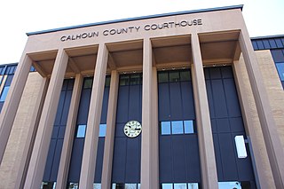
Calhoun County is a county located in the U.S. state of Florida. As of the 2020 census, the population was 13,648, making it the fifth-least populous county in Florida. Its county seat is Blountstown.

<span class="mw-page-title-main">Jackson County, Florida</span> County in Florida, United States

Jackson County is a county located in the U.S. state of Florida, on its northwestern border with Alabama. As of the 2020 census, the population was 47,319. Its county seat is Marianna.

<span class="mw-page-title-main">Jefferson County, Florida</span> County in Florida, United States

Jefferson County is a county located in the Big Bend region in the northern part of the U.S. state of Florida. As of the 2020 census, the population was 14,510. Its county seat is Monticello.

<span class="mw-page-title-main">Leon County, Florida</span> County in Florida, United States

Leon County is a county in the Panhandle of the U.S. state of Florida. It was named after the Spanish explorer Juan Ponce de León. As of the 2020 census, the population was 292,198.

<span class="mw-page-title-main">Liberty County, Florida</span> County in Florida, United States

Liberty County is a county located in the state of Florida. As of the 2020 census, the population was 7,974, making it the least populous county in Florida. Its county seat is Bristol. Liberty County is the only dry county in Florida. Lafayette County prohibits bars, but not retail sale of beer.

<span class="mw-page-title-main">Talbot County, Georgia</span> County in Georgia, United States

Talbot County is a county located in the west central portion of the U.S. state of Georgia. The 2020 census showed a population of 5,733. The county seat and largest city is Talbotton.

<span class="mw-page-title-main">Seminole County, Georgia</span> County in Georgia, United States

Seminole County is a county located in the southwestern corner of U.S. state of Georgia. As of the 2020 census, the population was 9,147. The county seat is Donalsonville.

<span class="mw-page-title-main">Early County, Georgia</span> County in Georgia, United States

Early County is a county located on the southwest border of the U.S. state of Georgia. As of the 2020 census, the population was 10,854. The county seat is Blakely, where the Early County Courthouse is located. Created on December 15, 1818, it was named for Peter Early, 28th Governor of Georgia. The county is bordered on the west by the Chattahoochee River, forming the border with Alabama.

<span class="mw-page-title-main">Apalachicola, Florida</span> City in Florida, United States of America

Apalachicola is a city and the county seat of Franklin County, Florida, United States, on the shore of Apalachicola Bay, an inlet of the Gulf of Mexico. The population was 2,341 at the 2020 census.

<span class="mw-page-title-main">Chattahoochee, Florida</span> City in Florida, United States

Chattahoochee is a city in Gadsden County, Florida, United States. Its history dates to the Spanish era. It is part of the Tallahassee, Florida Metropolitan Statistical Area. The population was 2,955 as of the 2020 census.

<span class="mw-page-title-main">Greensboro, Florida</span> Town in the state of Florida, United States

Greensboro is a town in Gadsden County, Florida, United States. The Town of Greensboro is part of the Tallahassee Metropolitan Statistical Area. The population was 461 at the 2020 US census, down from 602 at the 2010 US census.

<span class="mw-page-title-main">Gretna, Florida</span> City in Florida, United States

Gretna is a city in Gadsden County, Florida, United States. It is part of the Tallahassee, Florida Metropolitan Statistical Area. The majority of the population is African American, and as of the 2020 census, had 1,357 residents.

<span class="mw-page-title-main">Havana, Florida</span> Town in the state of Florida, United States

Havana is a town in Gadsden County, Florida, United States, and a suburb of Tallahassee. The population was 1,753 at the 2020 census. It is part of the Tallahassee Metropolitan Statistical Area. The town was named after Havana, Cuba, located about 530 miles (850 km) to the south.

<span class="mw-page-title-main">Midway, Gadsden County, Florida</span> City in Florida, United States of America

Midway is a city in Gadsden County, Florida, United States. It is part of the Tallahassee, Florida Metropolitan Statistical Area. According to the 2020 census, the population was 3,537.

<span class="mw-page-title-main">Quincy, Florida</span> City in Florida, United States of America

Quincy is a city in and the county seat of Gadsden County, Florida, United States. Quincy is part of the Tallahassee metropolitan area. The population was 7,970 as of the 2020 census.

<span class="mw-page-title-main">Florida State Road 12</span> Highway in Florida

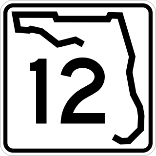
State Road 12 (SR 12) is an east–west route in the Florida Panhandle, running from SR 20 in Bristol to U.S. Route 27 (US 27) in Havana.

<span class="mw-page-title-main">Tallahassee metropolitan area</span> Metropolitan area in the United States

The Tallahassee Metropolitan Statistical area is the metropolitan area centered on Tallahassee, Florida.

<span class="mw-page-title-main">Mount Pleasant, Florida</span> Unincorporated community in Florida, U.S.

Mount Pleasant is an unincorporated community in Gadsden County, Florida, United States. It is located near the intersection of Blue Star Memorial Highway and Mt. Pleasant Road. Mt. Pleasant borders the city of Gretna and the St. John/Robertsville community. It also borders the city of Chattahoochee.

<span class="mw-page-title-main">Gadsden County School District</span>

Gadsden County School District (GCPS), or Gadsden County Schools (GCS), or Gadsden County Public Schools (GCPS), is a school district headquartered in the Max D. Walker School Administration Building in Quincy, Florida. It serves Gadsden County as its sole school district.

<span class="mw-page-title-main">West Gadsden High School</span> Defunct school in Florida, United States

West Gadsden High School was a public secondary school in unincorporated Gadsden County, Florida, operated by Gadsden County School District. It is adjacent to the city of Greensboro, and served grades 5–12. Its building now houses West Gadsden Middle School.

References

  1. "Gadsden County, Florida". United States Census Bureau . Retrieved January 30, 2022.
  2. "Find a County". National Association of Counties. Archived from the original on May 31, 2011. Retrieved June 7, 2011.
  3. Publications of the Florida Historical Society. Florida Historical Society. 1908. p. 31.
  4. Gannett, Henry (1905). The Origin of Certain Place Names in the United States. Govt. Print. Off. pp.  133.
  5. "US Gazetteer files: 2010, 2000, and 1990". United States Census Bureau. February 12, 2011. Retrieved April 23, 2011.
  6. "Annual Estimates of the Resident Population for Counties: April 1, 2020 to July 1, 2023". United States Census Bureau. Retrieved March 31, 2024.
  7. "Census of Population and Housing from 1790". US Census Bureau . Retrieved January 24, 2022.
  8. "Historical Census Browser". University of Virginia Library. Retrieved June 13, 2014.
  9. "Population of Counties by Decennial Census: 1900 to 1990". United States Census Bureau. Retrieved June 13, 2014.
  10. "Census 2000 PHC-T-4. Ranking Tables for Counties: 1990 and 2000" (PDF). United States Census Bureau. Retrieved June 13, 2014.
  11. 1 2 "P2: Hispanic or Latino, and Not Hispanic or Latino by Race – 2020: DEC Redistricting Data (PL 94-171) - Gadsden County, Florida". United States Census Bureau. Retrieved January 26, 2024.
  12. "P004: Hispanic or Latino, and Not Hispanic or Latino by Race – 2000: DEC Summary File 1 – Gadsden County, Louisiana". United States Census Bureau. Retrieved January 26, 2024.
  13. "P2: Hispanic or Latino, and Not Hispanic or Latino by Race – 2010: DEC Redistricting Data (PL 94-171) - Gadsden County, Florida". United States Census Bureau. Retrieved January 26, 2024.
  14. "U.S. Census website". United States Census Bureau . Retrieved May 14, 2011.
  15. "2020 CENSUS - SCHOOL DISTRICT REFERENCE MAP: Gadsden County, FL" (PDF). U.S. Census Bureau . Retrieved July 31, 2022. - Text list
  16. "SCHOOL MERGERS NOT POPULAR AT WEST GADSDEN". Havana Herald. March 3, 2017. Archived from the original on April 6, 2017. Retrieved April 6, 2017.
  17. Jiwanmall, Stephen (April 4, 2017). "Gadsden County Schools to Consolidate in 2017-18". WTXL . Retrieved April 6, 2017.
  18. Glenda Alice Rabby, The Pain and the Promise: The Struggle for Civil Rights in Tallahassee, Florida, Athens, Ga., University of Georgia Press, 1999, ISBN   082032051X, p. 255.
  19. Weigel, David; Tierney, Lauren (September 8, 2020). "Florida's political geography: Why races in this swing state are always so close". The Washington Post . Archived from the original on March 16, 2023.
  20. Sullivan, Robert David; ‘How the Red and Blue Map Evolved Over the Past Century’; America Magazine in The National Catholic Review; June 29, 2016
  21. David Leip’s Atlas of U.S. Presidential Elections; 1984 Presidential General Election Data Graphs – Florida by County
  22. "Voter Registration - Current by County - Division of Elections - Florida Department of State". Archived from the original on October 24, 2016. Retrieved October 27, 2016.
  23. Leip, David. "Dave Leip's Atlas of U.S. Presidential Elections". uselectionatlas.org. Retrieved June 14, 2018.
  24. "Gadsden County Supervisor of Elections > Elected Officials > Federal,State,Local-Officials".
  25. "Big Bend Transit | COORDINATED TRANSPORTATION SYSTEM OF GADSDEN COUNTY". www.bigbendtransit.org. Retrieved January 31, 2019.

Government links/Constitutional offices

Special districts

Judicial branch

30°35′N84°37′W / 30.58°N 84.61°W / 30.58; -84.61