East Florida

Last updated

East Florida
Territory of Great Britain (1763–1783), Spain (1783–1821), United States (1821–1822)
1763–1822
Red Ensign of Great Britain (1707-1800).svg
Flag of Cross of Burgundy.svg
Left: Red Ensign of Great Britain
Right: Flag of the Spanish Empire
Capital St. Augustine
Government
Governor  
 1763–1784
5 under Britain
 1784–1821
8 under Spain
 1821
1 U.S. military commissioner
History 
10 February, 1763
25 November 1783
1821
 Merged into Territory of Florida
30 March, 1822
Preceded by
Succeeded by
Flag of Spain (1785-1873, 1875-1931).svg Spanish Florida
Spanish Florida Flag of Spain (1785-1873, 1875-1931).svg

East Florida (Spanish : Florida Oriental) was a colony of Great Britain from 1763 to 1783 and a province of the Spanish Empire from 1783 to 1821. The British gained control over Spanish Florida in 1763 as part of the Treaty of Paris that ended the Seven Years' War. Deciding that the colony was too large to administer as a single unit, British officials divided Florida into two colonies separated by the Apalachicola River; the colony of East Florida, with its capital located in St. Augustine and West Florida, with its capital located in Pensacola. East Florida was much larger and comprised the bulk of the former Spanish colony and most of the current state of Florida. It had also been the most populated region of Spanish Florida, but before control was transferred to Britain, most residents – including virtually everyone in St. Augustine – left the territory, with most migrating to Cuba. [1]

Contents

Britain tried to attract settlers to the two Floridas without much success. The sparsely populated colonies were invited to send representatives to the Continental Congress but chose not to do so, and they remained loyal to Great Britain during the American Revolutionary War. However, as part of the 1783 treaty in which Britain officially recognized the independence of thirteen of its former colonies as the United States, it ceded both Floridas back to Spain, which maintained them as separate colonies while moving the boundary east to the Suwannee River.

By the early 1800s, Spain had proved uninterested in and incapable of organizing or defending either of the two Floridas much beyond the two small capital cities. American settlers moved into the territory without authorization, causing conflict with the Seminoles, a new Native American culture formed by indigenous refugees from the American Southeast. During the War of 1812, the American military invaded Florida, occupying West Florida while East Florida remained in Spanish hands. American settlers in East Florida further weakened Spanish control in 1812 when a group of Americans, mostly from Georgia, calling themselves the "Patriots," declared the short-lived Republic of East Florida at Amelia Island with semi-official support from the U.S. government.

Border disputes between the United States and Seminoles in Florida continued after the war. By 1817, much of Spanish West Florida had been occupied and annexed by the United States over Spanish objections, with the land eventually becoming portions of the states of Louisiana, Alabama, and Mississippi. After a decade of intensifying border disputes and American incursions, Spain ceded both Floridas to the U.S. in the Adams–Onís Treaty of 1819. The U.S. officially took possession in 1821; in 1822, all of East Florida and the few remaining portions of West Florida were combined into a single Florida Territory with borders that closely approximated those of the current state of Florida.

British period

Excerpt of 1803 map by John Cary showing East and West Florida, limited by the United States' claim to part of Spain-controlled West Florida. East and West Florida 1803 Cary Map.png
Excerpt of 1803 map by John Cary showing East and West Florida, limited by the United States' claim to part of Spain-controlled West Florida.

Under the terms of the 1763 Treaty of Paris, which ended the Seven Years' War (the French and Indian War), Spain ceded Spanish Florida to Britain. At the same time, Britain received all of French Louisiana east of the Mississippi River, with the exception of New Orleans, from France. Determining the new territory too large to administer as one unit, Britain divided its new southeastern acquisitions into two new colonies separated by the Apalachicola River: East Florida, with its capital in the old Spanish city of St. Augustine, and West Florida, with its capital at Pensacola. However, most of the Spanish population departed following the signing of the treaty, with the entirety of St. Augustine emigrating to Cuba. [1]

The settlement of East Florida was heavily linked in London to the same interests that controlled Nova Scotia. The East Florida Society of London and the Nova Scotia Society of London had many overlapping members, and Council frequently followed their suggestions on the granting of lands to powerful merchant interests in London.

Perhaps it is strange to think of such dissimilar geographic areas with such opposing climates as having much in common. But if one considers naval and military strategy, one can see that these areas have a common significance, especially when viewed from London by the ministry. Halifax (Nova Scotia) was the command post for both the admiral and general in charge of the American forces.... St. Augustine evoked the same strategic considerations. These posts have been described as the two centers of strength to which the British Army was withdrawn in the late 1760s. [2]

The apportionment of lands in the new colonies fell to the same group of English and Scottish entrepreneurs and merchant interests, led chiefly by the Englishman Richard Oswald, later a diplomat, and the British general James Grant, who would later become governor of East Florida. A list of the grantees in both Florida and Canada shows that the plums fell to a well-connected—and inter-connected—group. Lincoln's Inn barrister Levett Blackborne, grandson of Sir Richard Levett, a powerful merchant and Lord Mayor of London, came in for grants of 20,000 acres (81 km2) in both locales, for instance. Other aristocrats, nobles, and merchants did the same.

The most powerful lubricant between the East Florida speculators and the Nova Scotia speculators was Col. Thomas Thoroton of Flintham, Nottinghamshire. Thoroton, the stepbrother of Levett Blackborne, had married an illegitimate daughter of the Duke of Rutland and often lived at Belvoir Castle, where he acted as principal agent to the Duke, who, along with his son, the Marquis of Granby, were heavily involved in overseas ventures. Thoroton frequently acted as the go-between for Richard Oswald and James Grant, particularly after those two gave up their Nova Scotia Grants to focus on East Florida, where a drumbeat of steady speculation (particularly from Dr. Andrew Turnbull and Dr. William Stork) had fanned the flames of interest in London. [2] It was not until March 1781 that the Governor of East Florida, Patrick Tonyn, called elections for a provincial legislature. [3]

Both Floridas remained loyal to Great Britain during the American War of Independence. Britain used the territory as a temporary shelter for slaves as they attempted to remove all of them from the south. This slave removal was intended for dual purposes: firstly, it would provide labor for other British colonies, in particular holdings in the West Indies, and secondly, it would impact the wealth and economic capabilities of the American revolutionaries. [4]

Spain participated indirectly in the war as an ally of France and captured Pensacola from the British in 1781. In the 1783 Treaty of Paris, which ended the war, the British ceded both Floridas to Spain. The same treaty recognized the independence of the United States, directly to the north.

Demography

Racial demographics

During the period of British rule in East Florida, the black population came to outnumber the white population in the province by a ratio of 2 to 1. The ratio of blacks to whites in East Florida was lower than in British West Florida but higher than in the other southern British colonies. Those who were white in Florida generally served in the military or worked as overseers, artisans, or merchants. There were very few white yeomen farmers. White residents generally lived in or around St. Augustine with an exception being generally made for overseers and those who resided in New Smyrna. [5] Due to the poor treatment of Minorcans in New Smyrna, some left for St. Augustine, where a large number of them lived in a section of the city known as the "Minorcan Quarter" or the "Greek Quarter". [6]

Population and other characteristics

It is unclear what the population of East Florida was prior to the American Revolution but it is estimated to have had a population of close to 3,000, making it much larger in population than West Florida, which is believed to have had only several hundred residents. [7] The British tried to encourage settlement in East and West Florida, thinking it would take pressure off the proclamation line that colonists in the northern British colonies wanted to move beyond. However, this plan was generally unsuccessful as many of those who got land grants did not end up settling on those lands. [8] By 1783 the population of East Florida was about 17,000. [9]

During the American Revolution, East Florida sided with the British and became a loyalist haven. [10] With the end of the Revolution and the handing over of both Floridas to the Spanish, many loyalists were hesitant to leave. [11] In the end, most of the loyalist and British residents, approximately 10,000 people, left with most of these going to the Bahamas or West Indies and some going to Nova Scotia and England. Another 4,000 people "melted away into the wilderness", with some going as far away as the Mississippi River. [9]

A town named St. Johns Bluff or St. Johns Town was laid out in 1779 along the St. Johns River. The planned community was the first town to be established on the river. [12] Most of those who fled to Florida settled at that town and St. Augustine. St. Johns Bluff became a port and had 300 houses in it by the spring of 1783. [13] With the end of the British period, it was renamed as St. Vincent Ferrer before it was eventually abandoned. [12] A settlement named Rollestown was established by Denys Rolle 30 miles (48 km) southeast of St. Augustine, [14] on the east shore of the St. Johns River, south of Deep Creek. [15]

St. Augustine, the capital of the colony, was much smaller and less advanced than the capitals of the other Thirteen Colonies. [16]

Slavery and economics

East Florida did not establish a formal slave code until 1782. Those who were black or of mixed race of European and African origin and could not prove they were free were considered to be slaves. During the American Revolution, many Georgians and Carolinians moved to Florida along with their slaves. The colonial government, along with slave-owners, used slaves to construct defensive fortifications. A militia act that allowed for conscripting slaves as laborers and soldiers was passed in 1781. [13]

Goods produced and exported in East Florida included sugar, timber, indigo, rice, naval stores, and barrel staves; most of these goods came from plantations along the St. Marys and St. Johns rivers that used slave labor. [17]

Bernard Romans wrote the first account of Spanish fishing ranchos existing along Florida's southwest coast in 1770. [18] When the British took control of Florida, they monitored the fisherman but let them continue their activities. Governor James Grant was ordered to stop the fisherman from operating but did not enforce that order. At one point the fishing boats were suspected of being a threat to British control, but a complete review in 1767-68 found they were harmless. [19]

Media

Front page of the East Florida Gazette (Volume 1, no 16), a pro-loyalist newspaper. Front page of East Florida Gazette Vol. 1 (no.16).jpg
Front page of the East Florida Gazette (Volume 1, no 16), a pro-loyalist newspaper.

The East Florida Gazette was a pro-loyalist newspaper that was published weekly in St. Augustine from 1783 to 1784. It was founded by a loyalist printer, John Wells, and his brother, Dr. William Charles Wells, who had moved to St. Augustine from Charleston, South Carolina. [20] [21] [22] The paper was printed "'...at the Printing-office in Treasury-lane'" [23] Prior to the establishment of a newspaper, most news came into St. Augustine through gazettes that were published in Savannah, Georgia, and Charleston. [16]

The Wells brothers also published two books: Nature and the Principles of Public Credit, by Samuel Gale, along with The Case of the Inhabitants of East Florida, written by John Wells himself. [23] In 1783, another printer named David Zubly, who was a loyalist refugee from Savannah, Georgia, printed the first book in the colony, a copy of John Tobler's Almanack, at his home. [24]

Spanish period: Florida Oriental

Map of East and West Florida in 1819, the year that Spain ceded Florida to the United States by the Adams-Onis Treaty (ratified 1821) Map of East and West Florida in 1819.jpg
Map of East and West Florida in 1819, the year that Spain ceded Florida to the United States by the Adams–Onís Treaty (ratified 1821)

Under Spanish rule, the provinces of East Florida and West Florida initially remained divided by the Apalachicola River, the boundary established by the British. [25] [26] [27] However, Spain moved it eastward to the Suwanee River in 1785. [28] [29] [30]

"Under Spanish rule, Florida was divided by the natural separation of the Suwanee River into West Florida and East Florida."--University of Florida Historic Florida maps ("Territory of Florida Map 1 1820").gif
"Under Spanish rule, Florida was divided by the natural separation of the Suwanee River into West Florida and East Florida."—University of Florida

Spain continued to administer East and West Florida as separate provinces. The Spanish offered favorable terms for acquiring land, which attracted many settlers from the newly formed United States. There were several territorial disputes between the U.S. and Spain, some resulting in military action, including the Patriot War in 1812 and the filibuster at Amelia Island in 1817. [31] [32]

An American army under Andrew Jackson invaded East Florida during the First Seminole War. Jackson's forces captured San Marcos on 7 April 1818; as well as Fort Barrancas at West Florida's capital, Pensacola, on 24 May 1818.

James Monroe's Secretary of State, John Quincy Adams, defined the American position on this issue. Adams accused Spain of breaking Pinckney's Treaty by failing to control the Seminoles. Faced with the prospect of losing control, Spain formally ceded all of its Florida territory to the U.S. under the Adams–Onís Treaty in 1819 (ratified in 1821), in exchange for the U.S. ceding its claims on Texas and the U.S. paying any claims its citizens might have against Spain, up to $5,000,000.

In 1822, the U.S. Congress organized the Florida Territory, merging East Florida and the portion of West Florida that had remained under Spanish control until 1821. [33] In 1845, Florida was admitted as the 27th state of the United States.

Population and demographics

With the transfer of Florida to Spain, a number of former British subjects decided to stay while some Spaniards came to Florida. St. Augustine had a mix of both residents from the British period and newly arrived Spaniards. The rural areas settled by colonists were described as being "exclusively Anglo". [34] During the Spanish period, the population of St. Augustine "hovered" at about 3,000 people, with half of its population being black slaves. There were nine Native American towns in Florida, but those towns were not counted in the 1786 census. [35] In 1786, St. Augustine had a population of about 950 people. Three hundred of whom had some degree of African descent whether they were enslaved or not. [36]

Economics

With the return of the Spanish, the system of plantation agriculture developed in the colony during the British period remained. Although the production levels were not as high as other British colonies, cash crops like indigo, hemp, and rum made in Spanish East Florida led to economic growth there. As a result, St. Augustine became less dependent on the royal situado (royal financial payments for support). Trade became less restrictive during the second Spanish period as the Spanish monarchies enacted reforms allowing for trade between Spanish and non-Spanish areas, which benefited St. Augustine. [37]

St. Augustine was the largest port on the Atlantic Ocean south of Charleston. Ships would travel often to Charleston, South Carolina and Cap Français in Haiti where goods were traded and crews learned the latest news as well. [38] East Florida became economically dependent on the United States after Spain started to align with France and declared war on the British in 1796; as a result British trade largely stopped. Charleston began to surpass Havana as St. Augustine's biggest trading partner while Savannah, Philadelphia and New York City had become trading partners with the city. East Florida exported oranges, lumber and cotton to the United States while fish, grain and foodstuffs were imported from the United States. [39]

Spain was concerned about the Haitian Revolution, fearing that ideas of independence could be spread to their own colonies, including Florida, with Governor Quesada doing his best to follow the Spanish government's policy of prohibiting interactions with French possessions, "...forbidding the introduction of French ideas, books, citizens, or slaves originating from French possessions." [38]

Governors

List of governors of East Florida

NameTermNotes
John Hedges 20 Jul 1763 – 30 Jul 1763capital at St. Augustine (acting governor)
Francis Ogilvie 30 Jul 1763 – 29 Aug 1764acting governor
James Grant 29 Aug 1764 – 9 May 1771Considered the inaugural governor.
John Moultrie 9 May 1771 – 1 Mar 1774
Patrick Tonyn 1 Mar 1774 – 12 Jul 1784
Vicente Manuel de Céspedes y Velasco 12 July 1784 – July 1790capital at St. Augustine
Juan Nepomuceno de Quesada y Barnuevo July 1790 – March 1796
Bartolomé Morales March 1796 – June 1796acting governor
Enrique White June 1796 – March 1811
Juan José de Estrada March 1811 – June 1812 Patriot War with U.S.
Sebastián Kindelán y Oregón June 1812 – June 1815 Patriot War with U.S.
Juan José de Estrada June 1815 – January 1816
José María Coppinger January 1816 – 10 July 1821 First Seminole War with U.S.

See also

Related Research Articles

<span class="mw-page-title-main">St. Augustine, Florida</span> City in Florida, United States

St. Augustine is a city in and the county seat of St. Johns County located 40 miles south of downtown Jacksonville. The city is on the Atlantic coast of northeastern Florida. Founded in 1565 by Spanish explorers, it is the oldest continuously inhabited European-established settlement in what is now the contiguous United States.

The history of Florida can be traced to when the first Native Americans began to inhabit the peninsula as early as 14,000 years ago. They left behind artifacts and archeological evidence. Florida's written history begins with the arrival of Europeans; the Spanish explorer Juan Ponce de León in 1513 made the first textual records. The state received its name from that conquistador, who called the peninsula La Pascua Florida in recognition of the verdant landscape and because it was the Easter season, which the Spaniards called Pascua Florida.

<span class="mw-page-title-main">Treaty of Paris (1783)</span> Agreement ending the American Revolutionary War

The Treaty of Paris, signed in Paris by representatives of King George III of Great Britain and representatives of the United States on September 3, 1783, officially ended the American Revolutionary War and recognized the Thirteen Colonies, which had been part of colonial British America, to be free, sovereign and independent States.

<span class="mw-page-title-main">West Florida</span> Colony of Great Britain and a province of Spanish Florida

West Florida was a region on the northern coast of the Gulf of Mexico that underwent several boundary and sovereignty changes during its history. As its name suggests, it was formed out of the western part of former Spanish Florida, along with lands taken from French Louisiana; Pensacola became West Florida's capital. The colony included about two thirds of what is now the Florida Panhandle, as well as parts of the modern U.S. states of Louisiana, Mississippi, and Alabama.

<span class="mw-page-title-main">Florida Territory</span> Organized incorporated territory of the United States (1822–1845)

The Territory of Florida was an organized incorporated territory of the United States that existed from March 30, 1822, until March 3, 1845, when it was admitted to the Union as the State of Florida. Originally the major portion of the Spanish territory of La Florida, and later the provinces of East Florida and West Florida, it was ceded to the United States as part of the 1819 Adams–Onís Treaty. It was governed by the Florida Territorial Council.

<span class="mw-page-title-main">Castillo de San Marcos</span> United States historic place

The Castillo de San Marcos is the oldest masonry fort in the continental United States; it is located on the western shore of Matanzas Bay in the city of St. Augustine, Florida.

<span class="mw-page-title-main">Siege of Pensacola</span> 1781 battle of the American Revolutionary War

The siege of Pensacola, fought from March 9 to May 10, 1781, was the culmination of Spain's conquest of West Florida during the Gulf Coast Campaign of the American Revolutionary War.

<span class="mw-page-title-main">Spanish Florida</span> Former Spanish possession in North America (1513–1763; 1783–1821)

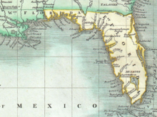
Spanish Florida was the first major European land-claim and attempted settlement-area in northern America during the European Age of Discovery. La Florida formed part of the Captaincy General of Cuba, the Viceroyalty of New Spain, and the Spanish Empire during Spanish colonization of the Americas. While its boundaries were never clearly or formally defined, the territory was initially much larger than the present-day state of Florida, extending over much of what is now the southeastern United States, including all of present-day Florida plus portions of Georgia, South Carolina, North Carolina, Alabama, Mississippi, and the Florida Parishes of Louisiana. Spain based its claim to this vast area on several wide-ranging expeditions mounted during the 16th century. A number of missions, settlements, and small forts existed in the 16th and to a lesser extent in the 17th century; they were eventually abandoned due to pressure from the expanding English and French colonial settlements, the collapse of the native populations, and the general difficulty in becoming agriculturally or economically self-sufficient. By the 18th century, Spain's control over La Florida did not extend much beyond a handful of forts near St. Augustine, St. Marks, and Pensacola, all within the boundaries of present-day Florida.

<span class="mw-page-title-main">British America</span> Former British territories in North America

British America comprised the colonial territories of the English Empire, and the successor British Empire, in the Americas from 1607 to 1783. These colonies were formally known as British America and the British West Indies immediately prior to thirteen of the colonies seceding in the American Revolutionary War (1775–1783) and forming the United States of America.

The history of Pensacola, Florida, begins long before the Spanish claimed founding of the modern city in 1698. The area around present-day Pensacola was inhabited by Native American peoples thousands of years before the historical era.

<span class="mw-page-title-main">Indian Reserve (1763)</span> Native North American Areas

"Indian Reserve" is a historical term for the largely uncolonized land in North America that was claimed by France, ceded to Great Britain through the Treaty of Paris (1763) at the end of the Seven Years' War—also known as the French and Indian War—and set aside for the First Nations in the Royal Proclamation of 1763. The British government had contemplated establishing an Indian barrier state in a portion of the reserve west of the Appalachian Mountains, bounded by the Ohio and Mississippi rivers and the Great Lakes. British officials aspired to establish such a state even after the region was assigned to the United States in the Treaty of Paris (1783) ending the American Revolutionary War, but abandoned their efforts in 1814 after losing military control of the region during the War of 1812.

<span class="mw-page-title-main">Panton, Leslie & Company</span> Scottish merchants in the Bahamas and Spanish Florida

Panton, Leslie & Company was a company of Scottish merchants active in trading in the Bahamas and with the Native Americans of what is now the Southeastern United States during the late 18th and early 19th centuries.

<span class="mw-page-title-main">Peace of Paris (1783)</span> 1783 treaties which ended the American Revolutionary War for all involved parties

The Peace of Paris of 1783 was the set of treaties that ended the American Revolutionary War. On 3 September 1783, representatives of King George III of Great Britain signed a treaty in Paris with representatives of the United States of America—commonly known as the Treaty of Paris (1783)—and two treaties at Versailles with representatives of King Louis XVI of France and King Charles III of Spain—commonly known as the Treaties of Versailles (1783). The previous day, a preliminary treaty had been signed with representatives of the States General of the Dutch Republic, but the final treaty which ended the Fourth Anglo-Dutch War was not signed until 20 May 1784; for convenience, however, it is included in the summaries below.

<span class="mw-page-title-main">British West Florida</span> Colony of the Kingdom of Great Britain

British West Florida was a colony of the Kingdom of Great Britain from 1763 until 1783, when it was ceded to Spain as part of the Peace of Paris.

Ahaya was the first recorded chief of the Alachua band of the Seminole tribe. European-Americans called him Cowkeeper, as he held a very large herd of cattle. Ahaya was the chief of a town of Oconee people near the Chattahoochee River. Around 1750 he led his people into Florida where they settled around Payne's Prairie, part of what the Spanish called tierras de la chua, "Alachua Country" in English. The Spanish called Ahaya's people cimarones, which eventually became "Seminoles" in English. Ahaya fought the Spanish, and sought friendship with the British, allying with them after Spain ceded Florida to Great Britain in 1763, and staying loyal to them through the American Revolutionary War. He died shortly after Britain returned Florida to Spain in 1783.

<span class="mw-page-title-main">The Floridas</span> Historical geopolitical term

The Floridas was a region of the southeastern United States comprising the historical colonies of East Florida and West Florida. They were created when England obtained Florida in 1763, and found it so awkward in geography that she split it in two. The borders of East and West Florida varied. In 1783, when Spain acquired West Florida and re-acquired East Florida from Great Britain through the Peace of Paris (1783), the eastern British boundary of West Florida was the Apalachicola River, but Spain in 1785 moved it eastward to the Suwannee River. The purpose was to transfer the military post at San Marcos de Apalachee and the surrounding district from East Florida to West Florida. From 1810 to 1813, the United States extended piecemeal control over the part of West Florida that comprised the modern-day Gulf coasts of Alabama and Mississippi and the Florida Parishes of Louisiana. After the ratification of the Adams-Onis Treaty in 1821 the United States combined East Florida and what had been the remaining Spanish-controlled rump of West Florida into the territory that comprised modern-day Florida.

<span class="mw-page-title-main">Spanish West Florida</span> Province of the Spanish Empire from 1783 to 1821

Spanish West Florida was a province of the Spanish Empire from 1783 until 1821, when both it and East Florida were ceded to the United States.

The Patriot War was an attempt in 1812 to foment a rebellion in Spanish East Florida with the intent of annexing the province to the United States. The invasion and occupation of parts of East Florida had elements of filibustering, but was also supported by units of the United States Army, Navy and Marines, and by militia from Georgia and Tennessee. The rebellion was instigated by General George Mathews, who had been commissioned by United States President James Madison to accept any offer from local authorities to deliver any part of the Floridas to the United States, and to prevent the reoccupation of the Floridas by Great Britain. The rebellion was supported by the Patriot Army, which consisted primarily of citizens of Georgia. The Patriot Army, with the aid of U.S. Navy gunboats, was able to occupy Fernandina and parts of northeast Florida, but never gathered enough strength to attack St. Augustine. United States Army troops and Marines were later stationed in Florida in support of the Patriots. The occupation of parts of Florida lasted over a year, but after United States military units were withdrawn and Seminoles entered the conflict, the Patriots dissolved.

The King's Road was a road built by the British in their colony of East Florida. It stretched from the St. Marys River, the border between East Florida and Georgia, to south of New Smyrna, and was mostly completed by 1773.

John Forbes (1767–1823) and his elder brother Thomas Forbes (d.1808) were Scottish traders who operated in East Florida, West Florida, Spanish Florida and the southeastern borderlands during the tail end of the eighteenth century. John Forbes & Company took control of the assets of its precursor trading firm, Panton, Leslie & Company, after William Panton died in 1801, followed by John Leslie in 1803.

References

  1. 1 2 "The British Period (1763–1784) – Fort Matanzas National Monument". U.S. National Park Service. Retrieved 5 January 2021.
  2. 1 2 The East Florida Society of London, Florida Historical Quarterly, Vol. LIV, No. 4, April 1976 Archived 14 January 2009 at the Wayback Machine
  3. The Impact of Loyalists in British East Florida Archived 10 April 2016 at the Wayback Machine , page 7
  4. Kirschke, James J. (May 2005). "Steps toward nationhood: Henry Laurens (1724–92) and the American Revolution in the South". Historical Research. 78 (200): 185. doi:10.1111/j.1468-2281.2005.00227.x . Retrieved 8 June 2022.
  5. Wright, J. Leitch Jr. (April 1976). "Blacks in British East Florida". The Florida Historical Quarterly. 54 (4): 3–4.
  6. Kotlik, George (2023). East Florida in the Revolutionary Era, 1763–1785. University of Georgia Press. pp. 67 & 68. ISBN   978-1-58838-538-3 via Google Books.
  7. Bauer, Deborah (Fall 2010). ""... in a strange place...": The Experiences of British Women during the Colonization of East & West Florida". The Florida Historical Quarterly. 89 (2): 145–185.
  8. Mowat, Charles (April 1940). "The Land Policy in British East Florida". Agricultural History. 14 (2). Agricultural History Society: 75–77. JSTOR   3739336 via JSTOR.
  9. 1 2 Peters, Thelma (October 1961). "The Loyalist Migration from East Florida to the Bahama Islands". The Florida Historical Quarterly. 40 (2). Florida Historical Society: 131.
  10. Peters 1961, p. 123
  11. Troxler, Carole (October 1989). "Refuge, Resistance, and Reward: The Southern Loyalists' Claim on East Florida". The Journal of Southern History. 55 (4): 563–596. doi:10.2307/2209041. JSTOR   2209041 via JSTOR.
  12. 1 2 "History of the St. Johns River". The Jacksonville Historical Society. Retrieved 19 May 2022.
  13. 1 2 Wright, J. Jr. (April 1976). "Blacks in British East Florida". The Florida Historical Quarterly. 54 (4): 6 & 9–10.
  14. Bauer, Deborah L. (2019). Trial & Error: Royal Authority & Families in the Colonization in the British Floridas, 1763-1784 (Thesis). University of South Florida.
  15. Schafer, Daniel L. (ed.). "Denys Rolle Plantation and Rollestown – Florida History Online". Florida History Online. University of North Florida. Retrieved 12 January 2024.
  16. 1 2 McCrady, James Waring; Bragg, C. L. (2020). Patriots in Exile: Charleston Rebels in St. Augustine during the American Revolution. Univ of South Carolina Press. p. 39. ISBN   978-1-64336-080-5.
  17. Wright Jr., J (April 1976). "Blacks in British East Florida". The Florida Historical Quarterly. 54 (4): 425–442.
  18. Stack, Margaret (2011). "Chapter 2: Background History". An Archaeological and Archival Appraisal of "Spanish Indians" on the West Coast of Florida in the Eighteenth and Nineteenth Centuries. pp. 10–13.
  19. Covington, James (1959). "Trade Relations Between Southwestern Florida and Cuba, 1600-1840". Florida Historical Quarterly. 38 (2). Florida Historical Society: 119. Retrieved 17 July 2022 via STARS.
  20. Wroth, Lawrence C. (1994). The Colonial Printer. Courier Corporation. pp. 51–52. ISBN   978-0-486-28294-7.
  21. "THE EAST FLORIDA GAZETTE, 1783–1784". Journal of the American Revolution. 26 February 2020. Retrieved 19 May 2022.
  22. Jasanoff, Maya (2012). Liberty's Exiles: American Loyalists in the Revolutionary World. Vintage Books. p. 380. ISBN   978-1-4000-7547-8.
  23. 1 2 McMurtrie, Douglas C. (1944). "The Beginnings of Printing in Florida". Florida Historical Quarterly. 23 (2) via STARS.
  24. Williams, Linda K. (1975). "East Florida as a Loyalist Haven" (PDF). Florida Historical Quarterly. 54 (4) via STARS.
  25. Bernard Romans (15 November 1999) [1775]. A Concise Natural History of East and West Florida. University of Alabama Press. p. 43. ISBN   978-0-8173-0876-6.
  26. James Grant Forbes (1821). Sketches, Historical and Topographical, of the Floridas: More Particularly of East Florida. C.S. Van Winkle. p.  120.
  27. A Journal of the Proceedings of the Senate of the Territory of Florida at its Second Session. publisher not identified. 1840. p. 81.
  28. Wright, J. Leitch (1972). "Research Opportunities in the Spanish Borderlands: West Florida, 1781–1821". Latin American Research Review. 7 (2). Latin American Studies Association: 24–34. doi: 10.1017/S0023879100041340 . JSTOR   2502623. S2CID   253149047. When Spain acquired West Florida in 1783, the eastern British boundary was the Apalachicola River, but Spain in 1785 moved it eastward to the Suwanee River. [at Footnote 1:"It was some time after 1785 before it was clearly established that Suwannee was the new eastern boundary of the province of Apalachee."] (Few maps indicate this eastward shift.) The purpose was to transfer San Marcos and the district of Apalachee from East Florida to West Florida.
  29. Weber, David J. (1992). The Spanish Frontier in North America. New Haven, Connecticut: Yale University Press. p. 275. ISBN   978-0-300-05917-5. Spain never drew a clear line to separate the two Floridas, but West Florida extended easterly to include Apalachee Bay, which Spain shifted from the jurisdiction of St. Augustine to more accessible Pensacola.
  30. "Territory of Florida Map 1". Historical Florida County Maps. University of Florida. 1936. Archived from the original on 3 February 2016. Under Spanish rule, Florida was divided by the natural separation of the Suwanee River into West Florida and East Florida. Upon the purchase of Florida, (1819) by the United States of America, West Florida and East Florida became two counties: Escambia County and St Johns County, so named and so ordained as counties with respective county governments by Andrew Jackson, Military Governor of the Territory of Florida.
  31. Cusick, James G. (2007). The other War of 1812 : the Patriot War and the American invasion of Spanish East Florida. Athens. pp. 293–294. ISBN   978-0820329215.{{cite book}}: CS1 maint: location missing publisher (link)
  32. Lowe, Richard G. (July 1966). "American Seizure of Amelia Island". The Florida Historical Quarterly. 45 (1): 19. Retrieved 27 December 2022.
  33. ""An Act for the establishment of a territorial government in Florida"". pp. 654–655. Archived from the original on 24 January 2016. Retrieved 30 March 2021.
  34. Parker, Susan R. (October 1990). "Men without God or King: Rural Settlers of East Florida, 1784-1790". The Florida Historical Quarterly. 69 (2): 135–155. JSTOR   30148603 . Retrieved 16 December 2022 via JSTOR.
  35. Mirow, M.C. (January 2015). "Law in East Florida 1783-1821". The American Journal of Legal History. 55 (1). Oxford University Press: 89–130. doi:10.1093/ajlh/55.1.89. JSTOR   24465375 . Retrieved 16 December 2022 via JSTOR.
  36. Johnson, Erica (2017). "Becoming Spanish in Florida: Georges Biassou and his "Family" in St. Augustine" (PDF). Journal of Transnational American Studies. 8 (1). doi:10.5070/T881036609 . Retrieved 21 December 2023 via escholarship.org.
  37. Velasquez, Daniel (2015). Persons, Houses, and Material Possessions: Second Spanish Period St. Augustine Society. University of Central Florida.
  38. 1 2 Landers, Jane (2017). "Franco/Spanish Entanglements in Florida and the Circumatlantic" (PDF). Journal of Transnational American Studies. 8 (1). doi:10.5070/T881036608 . Retrieved 21 December 2023 via escholarship.org.
  39. Marley, David (2005). Historic Cities of the Americas [2 Volumes]: An Illustrated Encyclopedia [2 Volumes]. Bloomsbury Publishing. p. 636. ISBN   9781576075746 . Retrieved 21 December 2005 via Google Books.

Further reading