
Gilchrist County is a county located in the north central part of the U.S. state of Florida. Organized in 1925 from the western part of Alachua, it is the last county to be formed in the state. As of the 2020 census, the population was 17,864. The county seat is Trenton.
In the United States, a metropolitan statistical area (MSA) is a geographical region with a relatively high population density at its core and close economic ties throughout the region. Such regions are not legally incorporated as a city or town would be and are not legal administrative divisions like counties or separate entities such as states. As a result, sometimes the precise definition of a given metropolitan area will vary between sources. The statistical criteria for a standard metropolitan area were defined in 1949 and redefined as a metropolitan statistical area in 1983.

The Blacksburg-Christiansburg Metropolitan Statistical Area, formerly the Blacksburg-Christiansburg-Radford Metropolitan Statistical Area, is a Metropolitan Statistical Area (MSA) as defined by the United States Office of Management and Budget (OMB) located in the New River Valley of Southwest Virginia. As of the 2020 census, the MSA had a population of 181,863.
Combined statistical area (CSA) is a United States Office of Management and Budget (OMB) term for a combination of adjacent metropolitan (MSA) and micropolitan statistical areas (μSA) across the 50 U.S. states and the territory of Puerto Rico that can demonstrate economic or social linkage. CSAs were first designated in 2003. OMB defines a CSA by various combinations of adjacent metropolitan and micropolitan areas with economic ties measured by commuting patterns. CSAs retain their own designations as metropolitan or micropolitan statistical areas in their respective larger combined statistical areas.

Pennsylvania has 14 U.S. Census Bureau-designated metropolitan statistical areas (MSAs) and four combined statistical areas (CSAs). As of 2020, Philadelphia, the seventh-largest United States metropolitan area, is the state's largest metropolitan area followed by Pittsburgh and Allentown.

The Sarasota metropolitan area is a metropolitan area located in Southwest Florida. The metropolitan area is defined by the Office of Management and Budget (OMB) as the North Port–Bradenton–Sarasota Metropolitan Statistical Area, a metropolitan statistical area (MSA) consisting of Manatee County and Sarasota County. The principal cities listed by the OMB for the MSA are North Port, Bradenton, Sarasota, Lakewood Ranch, and Venice. At the 2020 census, the MSA had a population of 833,716. The Census Bureau estimates that its population was 891,411 in 2022.
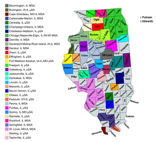
The U.S. State of Illinois currently has 43 statistical areas that have been delineated by the Office of Management and Budget (OMB). On March 6, 2020, the OMB delineated 11 combined statistical areas, 13 metropolitan statistical areas, and 19 micropolitan statistical areas in Illinois.
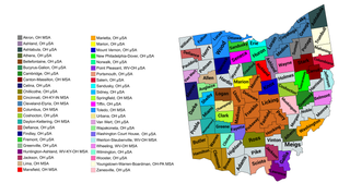
The U.S. State of Ohio currently has 55 statistical areas that have been delineated by the Office of Management and Budget (OMB). On July 21, 2023, the OMB delineated 11 combined statistical areas, 15 metropolitan statistical areas, and 29 micropolitan statistical areas in Ohio.
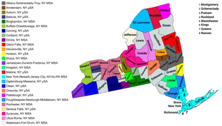
The U.S. state of New York currently has 34 statistical areas that have been delineated by the Office of Management and Budget (OMB). On March 6, 2020, the OMB delineated seven combined statistical areas, 14 metropolitan statistical areas, and 13 micropolitan statistical areas in New York.

The U.S. State of Arizona currently has 13 statistical areas that have been delineated by the Office of Management and Budget (OMB). On March 6, 2020, the OMB delineated two combined statistical areas, seven metropolitan statistical areas, and four micropolitan statistical areas in Arizona. The most populous of these statistical areas is the Phoenix-Mesa, AZ Combined Statistical Area with a 2020 Census population of 4,899,104.

The U.S. State of Alaska currently has four statistical areas that have been delineated by the Office of Management and Budget (OMB). On July 21, 2023, the OMB delineated two metropolitan statistical areas and two micropolitan statistical areas in Alaska. The most populous of these statistical areas is the Anchorage, AK Metropolitan Statistical Area with a 2020 Census population of 398,328.

The U.S. State of California currently has 39 statistical areas that have been delineated by the federal Office of Management and Budget (OMB). On March 6, 2020, the OMB delineated five combined statistical areas, 26 metropolitan statistical areas, and eight micropolitan statistical areas in California.

The U.S. State of Arkansas currently has 27 statistical areas that have been delineated by the Office of Management and Budget (OMB). On March 6, 2020, the OMB delineated four combined statistical areas, eight metropolitan statistical areas, and 15 micropolitan statistical areas in Arkansas.

The U.S. State of Florida currently has 35 statistical areas that have been delineated by the Office of Management and Budget (OMB). On July 21, 2023, the OMB delineated 7 combined statistical areas, 22 metropolitan statistical areas, and 6 micropolitan statistical areas in Florida.

The U.S. State of Georgia currently has 46 statistical areas that have been delineated by the Office of Management and Budget (OMB). On July 21, 2023, the OMB delineated 4 combined statistical areas, 14 Georgia-based metropolitan statistical areas, and 24 micropolitan statistical areas within Georgia.

The U.S. State of Nevada currently has 11 statistical areas that have been delineated by the Office of Management and Budget (OMB). On March 6, 2020, the OMB delineated two combined statistical areas, three metropolitan statistical areas, and six micropolitan statistical areas in Nevada.

The U.S. State of New Hampshire currently has eight statistical areas that have been delineated by the Office of Management and Budget (OMB). On July 21, 2023, the OMB delineated two combined statistical areas, two metropolitan statistical areas, and four micropolitan statistical areas in New Hampshire.

The Dothan–Enterprise–Ozark Combined Statistical Area was a CSA made up of five counties in the southeastern corner of the U.S. state of Alabama. The once statistical area includes one metropolitan area and originally one micropolitan area which then was split off as two. As of the 2010 census, the CSA had a population of 245,838. Currently an updated area called the Dothan-Ozark Combined Statistical area is used instead and Enterprise micropolitan area is now split as its own statistical area.
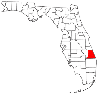
The Port St. Lucie, FL Metropolitan Statistical Area (MSA) includes St. Lucie and Martin counties in the Treasure Coast region of Florida.
The United States federal government defines and delineates the nation's metropolitan areas for statistical purposes, using a set of standard statistical area definitions. As of 2023, the U.S. Office of Management and Budget (OMB) defined and delineated 393 metropolitan statistical areas (MSAs) and 542 micropolitan statistical areas (μSAs) in the United States and Puerto Rico. Many of these 935 MSAs and μSAs are, in turn, components of larger combined statistical areas (CSAs) consisting of adjacent MSAs and μSAs that are linked by commuting ties; as of 2023, 582 metropolitan and micropolitan areas are components of the 184 defined CSAs. A collective term for MSAs, μSAs, and CSAs is primary statistical areas (PSAs), though that term is not used by OMB.


