Suwannee County, Florida

Last updated

Suwannee County
Suwannee County Courthouse01.jpg
Seal of Suwannee County, Florida.svg
Map of Florida highlighting Suwannee County.svg
Location within the U.S. state of Florida
Florida in United States.svg
Florida's location within the U.S.
Coordinates: 30°11′N82°59′W / 30.19°N 82.99°W / 30.19; -82.99
CountryFlag of the United States.svg United States
StateFlag of Florida.svg  Florida
FoundedDecember 21, 1858
Named for Suwannee River
Seat Live Oak
Largest cityLive Oak
Area
  Total692 sq mi (1,790 km2)
  Land689 sq mi (1,780 km2)
  Water3.7 sq mi (10 km2)  0.5%
Population
 (2020)
  Total43,474 [1]
Time zone UTC−5 (Eastern)
  Summer (DST) UTC−4 (EDT)
Congressional district 3rd
Website suwanneecountyfl.gov

Suwannee County is a county located in the north central portion of the state of Florida. As of the 2020 census, the population was 43,474, [1] up from 41,551 in 2010. [2] Its county seat is Live Oak. [3] Suwannee County was a dry county until August 2011, when the sale of alcoholic beverages became legal in the county. [4]

Contents

History

Suwannee County was created in 1858, [5] as railways were constructed through the area connecting it to Jacksonville, Tallahassee, and points north. It was named after the Suwannee River, which forms the county's northern, western, and much of its southern border. The word "Suwannee" may either be a corruption of the Spanish San Juan ("Saint John") or from the Cherokee sawani ("echo river").

During the American Civil War, Company K of the 3rd Florida Infantry Regiment was composed almost entirely of men from Suwannee County. In 1884, Florida's volunteer militia was reorganized and the Suwanee Rifles were established. The Rifles were among the twelve companies from Florida that were activated for service during the Spanish–American War. [6]

The rural areas supported numerous lumber and turpentine camps. In the 1930s, anthropologist Zora Neale Hurston did research in North Florida timber camps.

Geography

According to the U.S. Census Bureau, the county has a total area of 692 square miles (1,790 km2), of which 689 square miles (1,780 km2) is land and 3.7 square miles (9.6 km2) (0.5%) is water. [7]

Adjacent counties

Demographics

Historical population
CensusPop.Note
1860 2,303
1870 3,55654.4%
1880 7,161101.4%
1890 10,52447.0%
1900 14,55438.3%
1910 18,60327.8%
1920 19,7896.4%
1930 15,731−20.5%
1940 17,0738.5%
1950 16,986−0.5%
1960 14,961−11.9%
1970 15,5594.0%
1980 22,28743.2%
1990 26,78020.2%
2000 34,84430.1%
2010 41,55119.2%
2020 43,4744.6%
2023 (est.)46,130 [8] 6.1%
U.S. Decennial Census [9]
1790-1960 [10] 1900-1990 [11]
1990-2000 [12] 2010-2019 [2] 2020 [1]
Suwannee County racial composition as of 2020
(NH = Non-Hispanic) [lower-alpha 1]
RacePop 2010 [15] Pop 2020 [16] % 2010% 2020
White (NH)32,30031,66477.74%72.83%
Black or African American (NH)4,6964,92011.3%11.32%
Native American or Alaska Native (NH)1621670.39%0.38%
Asian (NH)2232700.54%0.62%
Pacific Islander (NH)11160.03%0.04%
Some Other Race (NH)371430.09%0.33%
Mixed/Multi-Racial (NH)5261,5091.27%3.47%
Hispanic or Latino 3,5964,7858.65%11.01%
Total41,55143,474100.00%100.00%

As of the 2020 United States census, there were 43,474 people, 15,149 households, and 10,655 families residing in the county.

As of the census [17] of 2000, there were 34,844 people, 13,460 households, and 9,691 families residing in the county. The population density was 51 people per square mile (20 people/km2). There were 15,679 housing units at an average density of 23 per square mile (8.9/km2). The racial makeup of the county was 84.53% White, 12.11% Black or African American, 0.39% Native American, 0.51% Asian, 0.04% Pacific Islander, 1.12% from other races, and 1.29% from two or more races. 4.89% of the population were Hispanic or Latino of any race.

There were 13,460 households, out of which 29.50% had children under the age of 18 living with them, 56.50% were married couples living together, 11.20% had a female householder with no husband present, and 28.00% were non-families. 23.30% of all households were made up of individuals, and 11.00% had someone living alone who was 65 years of age or older. The average household size was 2.54 and the average family size was 2.96.

In the county, the population was spread out, with 24.00% under the age of 18, 8.50% from 18 to 24, 25.10% from 25 to 44, 25.40% from 45 to 64, and 16.90% who were 65 years of age or older. The median age was 40 years. For every 100 females there were 95.40 males. For every 100 females age 18 and over, there were 92.90 males.

The median income for a household in the county was $29,963, and the median income for a family was $34,032. Males had a median income of $26,256 versus $21,136 for females. The per capita income for the county was $14,678. About 14.80% of families and 18.50% of the population were below the poverty line, including 21.90% of those under age 18 and 12.40% of those age 65 or over.

In March 2016, the county's unemployment rate was 4.8%.

Libraries

Suwannee County is served by the Suwannee River Regional Library System, which contains eight branches and also serves Hamilton and Madison counties.

Suwannee River Regional Library was first formed by a contractual agreement between Suwannee and Lafayette counties, making it the first regional library in Florida. [18] In 1957, the local Library Board learned that they might get a grant for a new library if they joined with another county. The Suwannee Board convinced the Mayo Woman's Club in Lafayette County to have their county join with Suwannee County and organize the first library region in Florida. With the formation of the duo-county, Suwannee-Lafayette Library Region, it immediately received $28,224 in funds. A small library was established at Mayo in Lafayette County in October 1957. The library started as a 3,100 book collection but soon grew to some 10,000 titles, some loaned from the State Library. A bookmobile was also added and put on the road.

After being successful with its new library, the Suwannee River Regional Library System was approached by a number of nearby counties interested in the project, and in 1959 Columbia, Gilchrist, Hamilton, Madison and Taylor counties qualified for membership and became a part of the system. Greenville, Jasper, Lake City, Madison, and Perry had small libraries operated by a Woman's Club that were also absorbed into the organization. By 1960, the library system now had 23,500 books in its collection, 3,000 of which were a gift from the Miami Public Library. On August 2 of that year, Dixie County became the last one to be invited to join in. Later, the Cross City library observed its official opening December 1, 1960. In May 1990 Madison County expanded by establishing a small satellite branch library in the Town of Lee. The Suwannee County library in Live Oak is the headquarters of the organization, as it has been since the establishment of the Suwannee River Regional Library System. [19]

Transportation

Airports

Suwannee County is accessed by air from Suwannee County Airport, located two miles west of Live Oak. It is a publicly operated airport run by the county government that has a paved runway in excess of 4,000 feet, major aircraft maintenance, training, car rental, as well as selling 100LL aviation fuel from a manned FBO. There are also many private airparks scattered throughout the county.

Railroads

Suwannee County has one surviving railroad line. The primary one is a Florida Gulf & Atlantic Railroad line formerly owned by CSX, Seaboard System Railroad, Seaboard Coast Line Industries and Seaboard Air Line Railroad that served Amtrak's Sunset Limited until it was truncated to New Orleans in 2005 by Hurricane Katrina. Union Depot and Atlantic Coast Line Freight Station was Suwannee County's premiere railroad station on the corner of US 129 & SR 136 in Live Oak, and served both the Atlantic Coast Line Railroad and Seaboard Air Line Railroad but has not been in use since 1971, with the termination of the Louisville and Nashville and Seaboard Coast Line's Gulf Wind (New Orleans - Jacksonville). The Seaboard Air Line operated two passenger trains a day in each direction until 1966 or 1967. [20] Various abandoned lines also exist within the county, one of which was converted into the Suwannee River Greenway Trail, along the southeastern part of the county.

Major roads

Communities

Towns

Unincorporated communities

Politics

Until 1964, Suwannee County, as part of the Solid South, voted with the Democratic presidential candidate every time. Since then, the only Democratic candidate to carry the county was Jimmy Carter, although he carried it both times in 1976 and 1980 despite losing the state and nationally in the latter.

United States presidential election results for Suwannee County, Florida [21]
Year Republican Democratic Third party
No.%No.%No.%
2020 16,41077.84%4,48521.27%1880.89%
2016 14,28776.05%3,96421.10%5362.85%
2012 12,67271.63%4,75126.85%2691.52%
2008 12,53470.77%4,91627.76%2611.47%
2004 11,15370.58%4,52228.62%1270.80%
2000 8,00964.27%4,07632.71%3763.02%
1996 5,74247.28%4,47936.88%1,92315.83%
1992 4,57640.23%3,98835.06%2,81024.71%
1988 5,86364.27%3,12934.30%1301.43%
1984 6,08268.57%2,78831.43%00.00%
1980 3,89946.22%4,34551.51%1922.28%
1976 2,40532.49%4,71863.74%2793.77%
1972 4,43580.77%1,02718.70%290.53%
1968 84514.13%1,18219.76%3,95566.12%
1964 3,00255.64%2,39344.36%00.00%
1960 1,53635.51%2,78964.49%00.00%
1956 1,04624.85%3,16375.15%00.00%
1952 1,61136.30%2,82763.70%00.00%
1948 3989.40%3,03371.62%80418.98%
1944 48316.05%2,52683.95%00.00%
1940 40112.27%2,86687.73%00.00%
1936 2026.59%2,86393.41%00.00%
1932 1637.13%2,12392.87%00.00%
1928 60631.68%1,28667.22%211.10%
1924 1119.50%97783.65%806.85%
1920 38218.65%1,48672.56%1808.79%
1916 563.94%1,20985.14%15510.92%
1912 545.26%71469.59%25825.15%
1908 15014.25%59756.70%30629.06%
1904 12516.23%58475.84%617.92%

See also

Notes

  1. Note: the US Census treats Hispanic/Latino as an ethnic category. This table excludes Latinos from the racial categories and assigns them to a separate category. Hispanics/Latinos can be of any race. [13] [14]

Related Research Articles

<span class="mw-page-title-main">Columbia County, Florida</span> County in Florida, United States

Columbia County is a county located in the north central portion of the U.S. state of Florida. As of the 2020 census, the population was 69,698, up from 67,531 at the 2010 census. Its county seat is Lake City.

<span class="mw-page-title-main">Dixie County, Florida</span> County in Florida, United States

Dixie County is a county located in the Big Bend region of the northern part of the U.S. state of Florida. As of the 2020 census, the population was 16,759. Its county seat is Cross City.

<span class="mw-page-title-main">Gilchrist County, Florida</span> County in Florida, United States

Gilchrist County is a county located in the north central part of the U.S. state of Florida. Organized in 1925 from the western part of Alachua, it is the last county to be formed in the state. As of the 2020 census, the population was 17,864. The county seat is Trenton.

<span class="mw-page-title-main">Hamilton County, Florida</span> County in Florida, United States

Hamilton County is a county located in the north central portion of the U.S. state of Florida. As of the 2020 census, the population was 14,004, down from 14,799 at the 2010 census. Its county seat is Jasper.

<span class="mw-page-title-main">Lafayette County, Florida</span> County in Florida, United States

Lafayette County is a county located in the north central portion of the state of Florida. As of the 2020 census, the population was 8,226, making it the second-least populous county in Florida. The county seat is Mayo. Lafayette County is a prohibition or partially dry county, allowing retail sales of beer.

<span class="mw-page-title-main">Jefferson County, Florida</span> County in Florida, United States

Jefferson County is a county located in the Big Bend region in the northern part of the U.S. state of Florida. As of the 2020 census, the population was 14,510. Its county seat is Monticello.

<span class="mw-page-title-main">Levy County, Florida</span> County in Florida, United States

Levy County is a county located on the Gulf coast in the northwestern part of the U.S. state of Florida. As of the 2020 census, the population was 42,915. Its county seat is Bronson.

<span class="mw-page-title-main">Madison County, Florida</span> County in Florida, United States

Madison County is a county located in the north central portion of the state of Florida, and borders the state of Georgia to the north. As of the 2020 census, the population was 17,968. Its county seat is also called Madison.

<span class="mw-page-title-main">Taylor County, Florida</span> County in Florida, United States

Taylor County is a county located in the Big Bend region in the northern part of the U.S. state of Florida. As of the 2020 census, the population was 21,796. Its county seat is Perry. The county hosts the annual Florida Forest Festival and has been long known as the "Tree Capital of the South" since a 1965 designation from then-Governor W. Haydon Burns.

<span class="mw-page-title-main">Fort White, Florida</span> Town in the state of Florida, United States

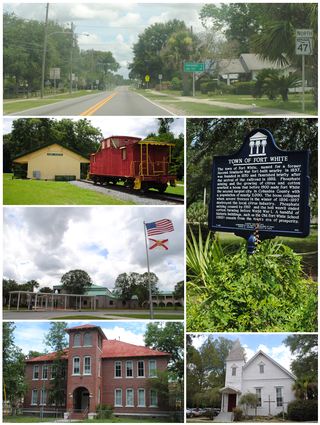
Fort White is a town in Columbia County, Florida, United States, named after a military fort built in the 1830s. It is the closest town to Ichetucknee Springs State Park. Fort White High School and the Fort White Public School Historic District are located within the town's borders. The original school building was constructed in 1915. As of the 2020 census, the population of Fort White was 618.

<span class="mw-page-title-main">Jasper, Florida</span> City in Florida, United States

Jasper is a city and the county seat of Hamilton County, Florida, United States. The population was 4,546 at the 2020 census.

<span class="mw-page-title-main">White Springs, Florida</span> Town in the state of Florida, United States

White Springs is a town in North Florida on the Suwannee River. The population was 740 at the 2020 census. Home of the annual Florida Folk Festival, it is a tourist destination noted for historic charm, antique shops, and river recreation.

<span class="mw-page-title-main">Plant City, Florida</span> City in Florida, United States

Plant City is an incorporated city in Hillsborough County, Florida, United States, approximately midway between Brandon and Lakeland along Interstate 4. It is part of the Tampa Bay area. The population was 39,764 at the 2020 census.

<span class="mw-page-title-main">Madison, Florida</span> City in Florida, United States

Madison is a city in and the county seat of Madison County, on the central northern border of Florida, United States. The population was 2,912 at the 2020 census.

<span class="mw-page-title-main">Branford, Florida</span> Town in Florida, United States

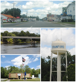
Branford is a town in Suwannee County, Florida, United States. The Town of Branford was officially incorporated as a municipality in 1961, although it has been settled since 1886. The population was 711 at the 2020 census.

<span class="mw-page-title-main">Live Oak, Florida</span> City in Florida, United States

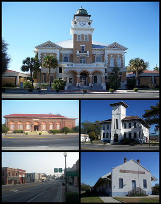
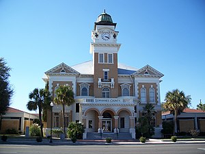
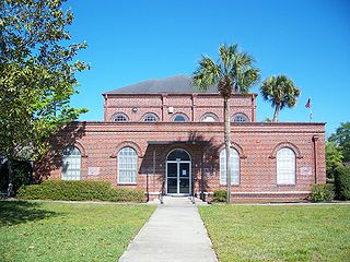
Live Oak is a city and the county seat of Suwannee County, Florida, United States. The city is located at the midpoint between Tallahassee and Jacksonville. As of 2020, the population recorded by the U.S. Census Bureau was 6,735.

<span class="mw-page-title-main">U.S. Route 27 in Florida</span> Section of U.S. Highway in Florida, United States

U.S. Highway 27 (US 27) in Florida is a north–south United States Numbered Highway. It runs 496.352 miles (798.801 km) from the Miami metropolitan area northwest to the Tallahassee metropolitan area. Throughout the state, US 27 has been designated the Claude Pepper Memorial Highway by the Florida Legislature. It was named after long-time Florida statesperson Claude Pepper, who served in both the U.S. Senate and House of Representatives. The stretch running from Miami to South Bay was originally designated the Thomas E. Will Memorial Highway by the Florida Legislature in 1937 when that portion was known as State Road 26 (SR 26). Thomas E. Will, the founder of Okeelanta, had worked for almost 20 years to get the state to build a road from Miami to the area south of Lake Okeechobee. For most of its length in the state, US 27 is a divided highway.

<span class="mw-page-title-main">U.S. Route 129 in Florida</span> Segment of American highway

U.S. Route 129 (US 129) in Florida is a north–south United States Highway. It runs 88 miles (142 km) from Chiefland north to the Georgia State Line in Levy, Gilchrist, Suwannee, and Hamilton Counties.

<span class="mw-page-title-main">Florida State Road 249</span> State highway in Florida, United States

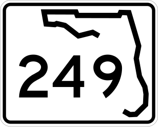
State Road 249 is the state designation for U.S. Route 129 between US 27(SR 20) in Branford and US 90(SR 10) in Live Oak. It also includes a bi-county extension in Suwannee County, Florida from Live Oak across the Suwannee River to Jasper in Hamilton County.

The Live Oak, Tampa and Charlotte Harbor Railroad was a historic railroad in Florida chartered by railroad tycoon Henry B. Plant. It was built as an extension of Plant's Live Oak and Rowlands Bluff Railroad. Together, the two lines ran from Live Oak, Florida to Gainesville via High Springs. The lines were completed in 1884.

References

  1. 1 2 3 "QuickFacts:Suwannee County, Florida". United States Census Bureau. Retrieved May 8, 2022.
  2. 1 2 "State & County QuickFacts". United States Census Bureau. Retrieved February 15, 2014.
  3. "Find a County". National Association of Counties. Retrieved June 7, 2011.
  4. "Suwannee Votes Wet", Suwannee Democrat
  5. Publications of the Florida Historical Society. Florida Historical Society. 1908. p. 34.
  6. Hawk, Robert (1986). Florida's Army : Militia, State Troops, National Guard, 1565-1985 (1st ed.). Englewood, Fla.: Pineapple Press. p. xxiii. ISBN   9780910923347.
  7. "US Gazetteer files: 2010, 2000, and 1990". United States Census Bureau. February 12, 2011. Retrieved April 23, 2011.
  8. "Annual Estimates of the Resident Population for Counties: April 1, 2020 to July 1, 2023". United States Census Bureau. Retrieved March 31, 2024.
  9. "U.S. Decennial Census". United States Census Bureau. Retrieved June 16, 2014.
  10. "Historical Census Browser". University of Virginia Library. Retrieved June 16, 2014.
  11. "Population of Counties by Decennial Census: 1900 to 1990". United States Census Bureau. Retrieved June 16, 2014.
  12. "Census 2000 PHC-T-4. Ranking Tables for Counties: 1990 and 2000" (PDF). United States Census Bureau. Retrieved June 16, 2014.
  13. https://www.census.gov/ [ not specific enough to verify ]
  14. "About the Hispanic Population and its Origin". www.census.gov. Retrieved May 18, 2022.
  15. "Explore Census Data". data.census.gov. Retrieved May 27, 2022.
  16. "Explore Census Data". data.census.gov. Retrieved May 27, 2022.
  17. "U.S. Census website". United States Census Bureau . Retrieved May 14, 2011.
  18. Nistendirk, Verna (1962). "Ten Years of Florida Library Progress". ALA Bulletin. 56 (5): 413–415. ISSN   0364-4006. JSTOR   25696429.
  19. "Suwannee River Regional Library". Digital Collections.
  20. Official Guide of the Railways, June 1966, Seaboard Air Line section
  21. Leip, David. "Dave Leip's Atlas of U.S. Presidential Elections". uselectionatlas.org.

Government links/Constitutional offices

Special districts

Judicial branch

Environmental

30°11′N82°59′W / 30.19°N 82.99°W / 30.19; -82.99