Transportation in Florida

Last updated

Transportation in Florida includes a variety of options, including Interstate Highways, U.S. Highways, and Florida State Roads; Amtrak and commuter rail services; airports, public transportation, and sea ports, in a number of the state's counties and regions.

Contents

Highways

Florida's interstates, U.S. Highways, and state highways are maintained by the Florida Department of Transportation, with the exception of a few highways in Miami, which are maintained by the Miami-Dade Expressway Authority (MDX).

Florida's interstate highway system contains 1,473 miles (2,371 km) of highway, and there are 9,934 miles (15,987 km) of non-interstate highway in the state, such as Florida state highways and U.S. Highways.[ citation needed ]

State highways are numbered according to convention. The first digits of state highways with some exceptions (such as State Road 112 (SR 112) connecting Interstate 95 (I-95) to the Miami International Airport) are numbered with the first digit indicating what area of the state the road is in, from 1 in the north and east to 9 in the south and west. Major north-south state roads generally have one- or two-digit odd route numbers that increase from east to west, while major east-west state roads generally have one- or two-digit even route numbers that increase from north to south. Roads of secondary importance usually have three-digit route numbers. The first digit x of their route number is the same as the first digit of the road with two-digit number x0 to the immediate north. The three-digit route numbers also increase from north to south for even numbers and east to west for odd numbers.

Following this convention, SR 907, or Alton Road on Miami Beach, is farther east than SR 997, which is Krome Avenue, or the farthest west north-south road in Miami–Dade County. One notable exception to the convention is SR 826, or the Palmetto Expressway (pictured at the right heading north) which, although even numbered, is signed north-south. State roads can have anywhere from one to four digits depending on the importance and location of the road. [1] County roads often follow this same system.

A law introduced on January 1, 2013, required all non US drivers to possess an International Driving License to drive within the state. The Florida Department for Highway Safety and Motor Vehicles issued a statement on February 14, 2013, announcing that the law would not be enforced. [2]

Railways

Intercity rail

Intercity heavy rail transport in Florida
Sunset Limited
to Los Angeles (suspended)
BSicon exCONTg cerulean.svg
Pensacola
BSicon exHST cerulean.svg
Crestview
BSicon exHST cerulean.svg
Chipley
BSicon exHST cerulean.svg
Tallahassee
BSicon exBHF cerulean.svg
Madison
BSicon exHST cerulean.svg
Lake City
BSicon exHST2 cerulean.svg
BSicon exSTRc3 cerulean.svg
BSicon CONTg cerulean.svg
BSicon exSTRc1 cerulean.svg
BSicon eABZg+4 cerulean.svg
BSicon BHF cerulean.svg
Jacksonville
Bus-logo.svg
BSicon HST cerulean.svg
Palatka
Bus-logo.svg
(Under construction)
SunRail logo.png
BSicon HST cerulean.svg
BSicon exlBHF orange.svg
BSicon LOGO Amtrak2.svg DeLand
BSicon KHSTa orange.svg
BSicon KSTRe cerulean.svg
DeBary
Bus-logo.svg
BSicon HST orange.svg
SunRail logo.png Sanford
LYNX Transportation Logo (Symbol Only).svg
BSicon STR orange.svg
BSicon lHST~L cerulean.svg
BSicon STRl cerulean.svg
BSicon lHST~R cerulean.svg
BSicon LOGO Amtrak2.svg Sanford (Auto Train)
BSicon HST orange.svg
Lake Mary
LYNX Transportation Logo (Symbol Only).svg
BSicon HST orange.svg
Longwood
LYNX Transportation Logo (Symbol Only).svg
BSicon HST orange.svg
Altamonte Springs
LYNX Transportation Logo (Symbol Only).svg
BSicon HST orange.svg
Maitland
LYNX Transportation Logo (Symbol Only).svg
BSicon BHF orange.svg
BSicon LOGO Amtrak2.svg Winter Park
LYNX Transportation Logo (Symbol Only).svg
BSicon HST orange.svg
AdventHealth
LYNX Transportation Logo (Symbol Only).svg
BSicon HST orange.svg
Lynx Central
LYNX Transportation Logo (Symbol Only).svg
BSicon HST orange.svg
Church Street
LYNX Transportation Logo (Symbol Only).svg
BSicon BHF orange.svg
BSicon LOGO Amtrak2.svg Orlando Health/Amtrak
LYNX Transportation Logo (Symbol Only).svg
BSicon HST orange.svg
Sand Lake Road
LYNX Transportation Logo (Symbol Only).svg
BSicon STR orange.svg
BSicon exSTR+l yellow.svg
BSicon exSTR+r yellow.svg
BSicon HST orange.svg
BSicon exSTR yellow.svg
Meadow Woods
LYNX Transportation Logo (Symbol Only).svg
BSicon exSTRc2 yellow.svg
BSicon STR orange.svg
BSicon exSTR3 yellow.svg
BSicon KINTxa yellow.svg
BSicon MONO.svg
BSicon FLUG.svg LYNX Transportation Logo (Symbol Only).svg
(proposed)
Walt Disney World
BSicon exSTRc2 yellow.svg
BSicon exBHF3+1 yellow.svg
BSicon exSTRc4 yellow.svg
BSicon HST orange.svg
BSicon STR yellow.svg
Tupperware
LYNX Transportation Logo (Symbol Only).svg
BSicon exSTR+1 yellow.svg
BSicon exSTRc4 yellow.svg
BSicon BHF orange.svg
BSicon STR yellow.svg
BSicon LOGO Amtrak2.svg Kissimmee
Greyhound no dog.svg LYNX Transportation Logo (Symbol Only).svg
BSicon exSTR yellow.svg
BSicon KHSTe orange.svg
BSicon KSTRa cerulean.svg
BSicon STR yellow.svg
Poinciana
LYNX Transportation Logo (Symbol Only).svg
(proposed)
Lakeland Brightlineicon.png
BSicon exBHF yellow.svg
BSicon HST+l cerulean.svg
BSicon ABZgr+r cerulean.svg
BSicon STR yellow.svg
BSicon LOGO Amtrak2.svg Lakeland
Bus-logo.svg
(proposed)
Tampa Brightlineicon.png
BSicon exKBHFe yellow.svg
BSicon KBHFe cerulean.svg
BSicon STR cerulean.svg
BSicon STR yellow.svg
BSicon LOGO Amtrak2.svg Tampa Gnome-searchtool.svg
BSicon BUS3.svg
BSicon lDAMPF.svg Willow
BSicon KHSTa.svg
BSicon BHF cerulean.svg
BSicon STR yellow.svg
Winter Haven
BSicon lDAMPF.svg Parrish
BSicon KHSTe.svg
BSicon BHF cerulean.svg
BSicon STR yellow.svg
Sebring
BSicon HST cerulean.svg
BSicon STR yellow.svg
Okeechobee
Bus-logo.svg
Mangonia Park
BSicon KHSTa lime.svg
BSicon KHSTe cerulean.svg
BSicon STR yellow.svg
Bus-logo.svg Greyhound no dog.svg BSicon FLUG.svg
West Palm Beach Tri-Rail.svg BSicon LOGO Amtrak2.svg
BSicon BHF lime.svg
BSicon BHF yellow.svg
Brightlineicon.png West Palm Beach
Bus-logo.svg
Bus-logo.svg
Lake Worth
BSicon HST lime.svg
BSicon STR yellow.svg
Bus-logo.svg
Boynton Beach
BSicon HST lime.svg
BSicon STR yellow.svg
Bus-logo.svg
Delray Beach BSicon LOGO Amtrak2.svg
BSicon BHF lime.svg
BSicon STR yellow.svg
Bus-logo.svg
Boca Raton Tri-Rail.svg
BSicon HST lime.svg
BSicon BHF yellow.svg
Brightlineicon.png Boca Raton
Bus-logo.svg
Deerfield Beach BSicon LOGO Amtrak2.svg
BSicon BHF lime.svg
BSicon STR yellow.svg
Bus-logo.svg
Pompano Beach
BSicon HST lime.svg
BSicon STR yellow.svg
Bus-logo.svg
Cypress Creek
BSicon HST lime.svg
BSicon STR yellow.svg
Bus-logo.svg Logo Miami-Dade County.svg
Fort Lauderdale Tri-Rail.svg BSicon LOGO Amtrak2.svg
BSicon BHF lime.svg
BSicon BHF yellow.svg
Brightlineicon.png Fort Lauderdale
Bus-logo.svg
Bus-logo.svg BSicon FLUG.svg
Fort Lauderdale Airport
BSicon BHF lime.svg
BSicon STR yellow.svg
Bus-logo.svg Logo Miami-Dade County.svg Greyhound no dog.svg
Sheridan Street
BSicon HST lime.svg
BSicon STR yellow.svg
Bus-logo.svg
Hollywood BSicon LOGO Amtrak2.svg
BSicon BHF lime.svg
BSicon BHF yellow.svg
Brightlineicon.png Aventura
Bus-logo.svg Logo Miami-Dade County.svg Greyhound no dog.svg
Golden Glades
BSicon STRc2 lime.svg
BSicon HST3 lime.svg
BSicon STR yellow.svg
Logo Miami-Dade County.svg
Opa-locka
BSicon HST+1 lime.svg
BSicon STRc4 lime.svg
BSicon STR yellow.svg
BSicon STR lime.svg
BSicon STRl cerulean.svg
BSicon KBHFeq cerulean.svg
BSicon STR yellow.svg
BSicon LOGO Amtrak2.svg Miami
Logo Miami-Dade County.svg
Tri-Rail/Metrorail Transfer MDTMetro.svg
BSicon INT lime.svg
BSicon STRc2 yellow.svg
BSicon STR3 yellow.svg
BSicon STR lime.svg
BSicon exKRWl.svg
BSicon STR+1 yellow.svg
BSicon exKRW+r.svg
BSicon STRc4 yellow.svg
Tri-Rail Downtown Miami Link
(opens 2023)
Logo Miami-Dade County.svg
Hialeah Market
BSicon HST lime.svg
BSicon STR yellow.svg
Logo Miami-Dade County.svg Greyhound no dog.svg
Gnome-searchtool.svg Miami Int'l Airport MDTMetro.svg
BSicon KINTe lime.svg
BSicon lhSTRa@f.svg
BSicon eABZgl yellow.svg
BSicon exKBHFeq yellow.svg
Brightlineicon.png PortMiami
(planned)
BSicon hKINTe yellow.svg
Brightlineicon.png MDTMetro.svg BSicon MONO.svg MiamiCentral Gnome-searchtool.svg
Logo Miami-Dade County.svg Bus-logo.svg
Services
SunRail logo.png
BSicon STRq orange.svg
SunRail
Brightlineicon.png
BSicon STRq yellow.svg
Brightline only
Tri-Rail.svg
BSicon STRq lime.svg
Tri-Rail
BSicon LOGO Amtrak2.svg
BSicon STRq cerulean.svg
Amtrak only
BSicon DAMPF.svg
Florida Railroad Museum

Amtrak service exists in Florida. Sanford, in Greater Orlando, is the southern terminus of the Amtrak Auto Train, which originates at Lorton, Virginia, south of Washington, DC. Orlando is also the eastern terminus of the Sunset Limited, which travels across the southern United States via New Orleans, Houston, and San Antonio to its western terminus of Los Angeles; however, service to Florida has been suspended indefinitely in the aftermath of Hurricane Katrina. Florida is served by two additional Amtrak trains (the Silver Star and the Silver Meteor), which operate between New York City and Miami. In 2015, Amtrak had a total of 1,027,196 boardings and alightings in the state of Florida. [3]

Brightline is a higher-speed service connecting Miami, Aventura, Ft. Lauderdale, Boca Raton, West Palm Beach, and Orlando. There are plans for Brightline to reach Tampa in the future via Disney Springs at Walt Disney World. [4]

High Speed Intercity Rail

The Florida Department of Transportation was preparing to build a high-speed rail between Tampa, Lakeland and Orlando. This is the first phase of the Florida High Speed Rail system. Soil work began in July 2010 with the federal government expecting full construction to begin in 2011. However, Governor Rick Scott declined the federal funding.

Florida voters approved a state constitutional amendment in 2000 for the construction of a high-speed rail network. Due to public skepticism about the multibillion-dollar price, voters repealed this amendment. [5] The first segment of this network, projected to have opened in 2009, would have connected Tampa and Orlando, in hopes of alleviating traffic on the busy Interstate 4 corridor. Later segments would have connected Miami, Fort Myers, Jacksonville, Tallahassee, and Pensacola.

Airports

Florida has 131 public airports. [6] Florida's seven large hub and medium hub airports, as classified by the FAA, are the following:

Florida large and medium hub airports
City servedCodeAirport nameFAA
Category
Enplanements
Miami MIA Miami International Airport Large Hub17,017,654
Orlando MCO Orlando International Airport Large Hub17,017,491
Fort Lauderdale FLL Fort Lauderdale–Hollywood Int'l Airport Large Hub10,829,810
Tampa TPA Tampa International Airport Large Hub8,137,222
Fort Myers RSW Southwest Florida International Airport Medium Hub3,714,157
West Palm Beach PBI Palm Beach International Airport Medium Hub2,958,416
Jacksonville JAX Jacksonville International Airport Medium Hub2,755,719

Major international airports in Florida which processed more than 15 million passengers each in 2005 are Orlando International Airport (34,128,048 est. 2006), Miami International Airport (32,533,974 est. 2006), Fort Lauderdale-Hollywood International Airport(22,390,285 est. 2006) and Tampa International Airport (19,045,390 est. 2006).

Secondary airports, with annual passenger traffic exceeding 5 million each in 2005, include Southwest Florida International Airport (Fort Myers) (7,518,169 est. 2006), Palm Beach International Airport (West Palm Beach) (7,014,237 est. 2006), Jacksonville International Airport (5,741,652).

Regional Airports which processed over one million passengers each in 2005 are Pensacola (1,638,605), Sarasota-Bradenton (1,337,571), and Tallahassee (1,129,947) and Sanford (1,649,237) which is primarily served by international charter airlines. [7]

Other smaller, regional airports with commercial service (with passengers served in 2005, where available) include those at Daytona Beach (615,841), Fort Walton Beach (520,000), Gainesville (345,788), Key West, Marathon Key, Melbourne (466,367), Naples, Panama City (382,551), and St. Petersburg-Clearwater (596,510).

Canals

Florida is part of the Intracoastal Waterway, a 3,000 mile (4,800 km) inland waterway. Florida has the Okeechobee Waterway, St. Lucie Canal (C-44), Miami Canal and the Cross Florida Barge Canal.

Public transportation

Miami's public transportation is served by Miami-Dade Transit, which runs Metrorail, a heavy rail rapid transit system; Metromover, a people mover train system in Downtown Miami; and Metrobus, Miami-Dade's bus system. Metrorail runs throughout Miami-Dade County and has 23 stations on a 24.4-mile (39.3 km) track connecting to Downtown Miami's Metromover and Tri-Rail. Metromover has three lines and 21 stations on a 4.4-mile (7.1 km) track connecting Uptown and the Brickell Financial District inside of Downtown Miami. Outside of Miami-Dade County, public transit in the South Florida metropolitan area is served by Broward County Transit and Palm Tran; intercounty heavy rail service is provided by Tri-Rail, with 18 stations including the region's three international airports.

Tampa and its surrounding area is served by buses run by Hillsborough Area Regional Transit, or HART for short. In addition, HART runs continuous trolley services in downtown Tampa in the form of the TECO Line Streetcar, a heritage streetcar line sponsored by Tampa Electric Company. Pinellas County and St. Petersburg provide similar services through the Pinellas Suncoast Transit Authority, or PSTA for short. The beaches of Pinellas County have their own bus system run by PSTA called the Suncoast Beach Trolley. Downtown St. Petersburg also has a separate bus system, known as The Looper. The Cross-Bay Ferry has connected Tampa's Channelside District to Downtown St. Petersburg since 2016. [8]

Greater Orlando utilizes the Lynx bus system, which also operates a free bus rapid transit service in downtown Orlando. [9] A commuter rail service – SunRail – also serves the Metro Orlando area. The Walt Disney World Resort is also located in this area and is served by Disney Transport, its own internal transportation system consisting of buses, watercraft, parking lot trams, and the Walt Disney World Monorail System. The latter is one of the busiest mass transit rail systems in North America, with over 150,000 riders served each day. [10]

Public transportation in Jacksonville is provided by Jacksonville Transportation Authority (JTA), operating bus service, trolleys, paratransit, and a people mover. The people mover, known as the JTA Skyway is located in downtown Jacksonville, and operates 8 stations along a 2.5 miles (4.0 km) track. Bus service as well as paratransit service is provided around Duval County and partially in Clay County. JTA operates three trolley lines in three different neighborhoods: Downtown, Riverside, and Jacksonville Beach. The entire JTA system has a daily ridership of over 42,000. [11]

In Volusia County, VoTran provides bus transportation throughout the entire county. Express service to Orlando was provided between 1998 and 2014 and has since been replaced by SunRail.

In Polk County, the Citrus Connection and Winter Haven Area Transit (WHAT) provide regional transportation in the cities of Lakeland, Bartow, Winter Haven, Auburndale and smaller surrounding municipalities and unincorporated areas. WHAT connects with the Lynx system at Haines City.

The Gainesville metropolitan area is served by the fourth largest public transit system in the state of Florida. Gainesville Regional Transit System or RTS presently serves 40 city routes (19 on Saturdays, 16 on Sundays), 10 campus routes, and five "Later Gator" routes. Paratransit (ADA) service is also provided to anyone with a Gainesville address. RTS has a daily ridership of approximately 25,000 riders.

On April 1, 2016, Florida governor Rick Scott signed a video surveillance bill that was to be used in public Transit systems throughout the state. Public Transits may release their video surveillance to local, state or federal agencies in furtherance of civic duty and responsibility; They may release video footage upon showing good cause to a court of competent jurisdiction. [12]

Intercity Bus

Bus service between cities and towns in Florida is provided by a number of private companies. Amtrak Thruway service is offered connecting Amtrak trains to cities off of train routes, including Fort Myers and St Augustine, but tickets cannot be purchased for the bus alone, only a combined bus-rail itinerary.

List of Florida roads

Interstates

Road nameSouth or west terminusNorth or east terminusNotes
I-4.svg I-4 Tampa Daytona Beach Has junctions with I-75 in Tampa and I-95 in Daytona Beach.
I-10.svg I-10 Alabama state line, near Pensacola Jacksonville Has junctions with I-75 near Lake City and I-95 in Jacksonville.
I-75.svg I-75 Hialeah/Miami Lakes Georgia state line, near Lake City Has junctions with I-10 in Lake City and I-4 in Tampa.
I-95.svg I-95 Downtown Miami Georgia state line, near Jacksonville Has junctions with I-10 in Jacksonville and I-4 in Daytona Beach.

Auxiliary Interstates

Road nameNotes
I-110.svg I-110 A spur from I-10 into downtown Pensacola.
I-175.svg I-175 Connects I-275 to southern downtown St. Petersburg.
I-195.svg I-195 An extension of Miami's Airport Expressway (SR 112); a spur eastward from I-95 to Miami Beach.
I-275.svg I-275 A 60 miles (97 km) [13] westward half-loop from I-75 north of Ellenton, over the Sunshine Skyway Bridge, through St. Petersburg, to Tampa International Airport and downtown Tampa, reconnecting with I-75 in Tampa's northern suburbs.
I-295.svg I-295 A beltway around Jacksonville.
I-375.svg I-375 Connects I-275 to northern downtown St. Petersburg.
I-395.svg I-395 An extension of Miami's Dolphin Expressway (SR 836); a spur eastward from I-95 to Miami Beach.
I-595.svg I-595 Connects I-75, I-95, Fort Lauderdale-Hollywood International Airport, and Port Everglades.

Toll roads

Florida has several toll roads, totaling 515 miles (829 km) of the state highway system. Major toll roads include:

U.S. Routes

Funding

Federal, state and local governments pay for road construction and maintenance. In 2015, the federal government approved $12 billion over the next five years. $10 Billion will be used for the highway program. $2 billion will be used for mass transit systems. [14]

See also

Related Research Articles

<span class="mw-page-title-main">Interstate 4</span> Interstate Highway in Florida, United States

Interstate 4 (I-4) is an Interstate Highway located entirely within the US state of Florida, maintained by the Florida Department of Transportation (FDOT). Spanning 132.30 miles (212.92 km) along a generally southwest–northeast axis, I-4 is entirely concurrent with State Road 400 (SR 400). In the west, I-4 begins at an interchange with I-275 in Tampa. I-4 intersects with several major expressways as it traverses Central Florida, including US Highway 41 (US 41) in Tampa; US 301 near Riverview; I-75 near Brandon; US 98 in Lakeland; US 27 in unincorporated Davenport; US 192 in Celebration; Florida's Turnpike in Orlando; and US 17 and US 92 in multiple junctions. In the east, I-4 ends at an interchange with I-95 in Daytona Beach, while SR 400 continues for roughly another four miles (6.4 km) and ends at an intersection with US 1 on the city line of Daytona Beach and South Daytona.

<span class="mw-page-title-main">Tri-Rail</span> Commuter rail service in South Florida

Tri-Rail is a commuter rail line linking Miami, Fort Lauderdale and West Palm Beach in Florida, United States. The Tri prefix in the name refers to the three counties served by the railroad: Palm Beach, Broward, and Miami-Dade. Tri-Rail is managed by the South Florida Regional Transportation Authority (SFRTA) along CSX Transportation's former Miami Subdivision; the line is now wholly owned by the Florida DOT. The 70.9-mile-long (114.1 km) system has 18 stations along the Southeast Florida coast, and connects directly to Amtrak at numerous stations, and to Metrorail at the Tri-Rail and Metrorail Transfer station and at Miami Intermodal Center.

<span class="mw-page-title-main">Florida High-Speed Corridor</span> Canceled state-sponsored electric rail service between Tampa and Miami

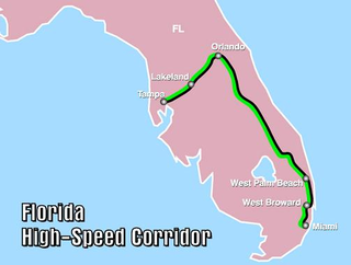
The Florida High-Speed Corridor is a canceled high-speed rail project in the U.S. state of Florida. Initial service would have run between the cities of Tampa and Orlando, with plans to then extend service to South Florida, terminating in Miami. Trains with a top speed of 168 mph (270 km/h) to 186 mph (300 km/h) would run on dedicated rail lines alongside the state's existing highway network.

<span class="mw-page-title-main">Government Center station (Miami)</span> Miami-Dade Transit metro station

Government Center station is an intermodal transit hub in the Government Center district of Downtown Miami, Florida. It is operated by Miami-Dade Transit and serves as a transfer station for the Metrorail and Metromover rapid transit systems and as a bus station for Metrobus, Paratransit, and Broward County Transit buses. The station is located near the intersection of Northwest First Street and First Avenue, a part of the Stephen P. Clark Government Center Building. It opened to service May 20, 1984, next to the site of a former FEC railway station which is now MiamiCentral.

<span class="mw-page-title-main">Central Florida</span> Region in Florida, United States

Central Florida is a region of the U.S. state of Florida. Different sources give different definitions for the region, but as its name implies it is usually said to comprise the central part of the state, including the Tampa Bay area and the Greater Orlando area, though in recent times the Tampa Bay area has often been described as its own region, with "central Florida" becoming more synonymous with the Orlando area.

<span class="mw-page-title-main">Transportation in Virginia</span> Overview of land sea and air transport systems in Virginia

Transportation in the Commonwealth of Virginia is by land, sea and air. Virginia's extensive network of highways and railroads were developed and built over a period almost 400 years, beginning almost immediately after the founding of Jamestown in 1607, and often incorporating old established trails of the Native Americans.

<span class="mw-page-title-main">Interstate 95 in Florida</span> Highway in Florida

Interstate 95 (I-95) is the main Interstate Highway of Florida's Atlantic Coast. It begins at a partial interchange with US Highway 1 (US 1) just south of downtown Miami and heads north through Jacksonville, and to the Georgia state line at the St. Marys River near Becker. The route also passes through the cities of Fort Lauderdale, West Palm Beach, Port St. Lucie, Titusville, and Daytona Beach.

<span class="mw-page-title-main">Miami Intermodal Center</span> Ground transportation hub for Miami International Airport

Miami Intermodal Center (MIC) is an intermodal rapid transit, commuter rail, intercity rail, local bus, and intercity bus transportation hub in Miami-Dade County, Florida, just outside the Miami city limits near the Grapeland Heights neighborhood. The facility was constructed by the Florida Department of Transportation and is owned by the Miami-Dade Expressway Authority.

<span class="mw-page-title-main">Cityscape of Tampa, Florida</span>

The cityscape of Tampa includes historic and architecturally noteworthy structures in its downtown and residential areas. The Seminole Heights and Hyde Park neighborhoods are two of the largest historic preservation districts in Tampa.

There have been plans in Florida for expressways, but some were never constructed due to financial problems, community opposition and environmental issues.

The following is an alphabetical list of articles related to the U.S. state of Florida.

The transportation system of Georgia is a cooperation of complex systems of infrastructure comprising over 1,200 miles (1,900 km) of interstates and more than 120 airports and airbases serving a regional population of 59,425 people.

<span class="mw-page-title-main">SunRail</span> Commuter rail system in the Greater Orlando, Florida, area

SunRail is a commuter rail system in the Greater Orlando, Florida, area. Services began on May 1, 2014. The system comprises 16 stations along a former CSX Transportation line connecting Volusia County and Osceola County through Downtown Orlando. The SunRail system is financed by the state and federal governments and the counties it serves. SunRail is Florida's second commuter rail system after South Florida's Tri-Rail.

<span class="mw-page-title-main">Transportation in Hampton Roads</span>

Historically, the harbor was the key to the Hampton Roads area's growth, both on land and in water-related activities and events. Ironically, the harbor and its tributary waterways were both important transportation conduits and obstacles to other land-based commerce and travel. For hundreds of years, state and community leaders have worked to develop solutions to accommodate both.

<span class="mw-page-title-main">Transportation in New Jersey</span> Overview of the transportation in New Jersey

Transportation in New Jersey utilizes a combination of road, rail, air, and water modes. New Jersey is situated between Philadelphia and New York City, two major metropolitan centers of the Boston-Washington megalopolis, making it a regional corridor for transportation. As a result, New Jersey's freeways carry high volumes of interstate traffic and products. The main thoroughfare for long distance travel is the New Jersey Turnpike, the nation's fifth-busiest toll road. The Garden State Parkway connects the state's densely populated north to its southern shore region. New Jersey has the 4th smallest area of U.S. states, but its population density of 1,196 persons per sq. mi causes congestion to be a major issue for motorists.

<span class="mw-page-title-main">Transportation in Jacksonville, Florida</span> Overview of transportation in Jacksonville, Florida

The Jacksonville transportation network includes ground, air, and sea options for passenger and freight transit. The Jacksonville Port Authority (Jaxport) operates the Port of Jacksonville, which includes container shipping facilities at Blount Island Marine Terminal, the Talleyrand Marine Terminal and the Dames Point Marine Terminal. Jacksonville Aviation Authority managers Jacksonville International Airport in Northside, as well as several smaller airports. The Jacksonville Transportation Authority (JTA) operates bus, people mover, and park-n-ride services throughout the city and region. A major bus terminal at the intermodal Rosa Parks Transit Station serves as JTA's main transit hub. Various intercity bus companies terminate near Central Station. Amtrak operates passenger rail service to and from major cities throughout North America. The city is bisected by major highways, I-95 and I-10, I-295 creates a full beltway around the city.

This article is intended to give an overview of transportation in North Carolina.

<span class="mw-page-title-main">Transportation in South Florida</span> Overview of transportation in South Florida

The Greater Miami area, composed of the three counties of Miami-Dade, Broward, and Palm Beach, also known collectively as South Florida, is home to a wide variety of public and private transportation systems. These include heavy rail mass transit (Metrorail), commuter rail (Tri-Rail), automated guideway transit (Metromover), highways, two major airports and seaports, as well as three county-wide bus networks, which cover the entire urbanized area of South Florida. Census and ridership data show that Miami has the highest public transportation usage of any city in Florida, as about 17% of Miamians use public transportation on a regular basis, compared to about 4% of commuters in the South Florida metropolitan area. The majority of public transportation in Miami is operated by Miami-Dade Transit (MDT), which is currently the largest transit system in Florida and was the 14th largest transit system in the United States in 2011.

<span class="mw-page-title-main">Brightline</span> Intercity rail route in Florida

Brightline is an inter-city rail route in the United States that runs between Miami and Orlando, Florida. Part of the route runs on track owned and shared by the Florida East Coast Railway.

<span class="mw-page-title-main">Seaboard–All Florida Railway</span>

The Seaboard–All Florida Railway was a subsidiary of the Seaboard Air Line Railroad that oversaw two major extensions of the system in the early 1920s to southern Florida on each coast during the land boom. One line extended the Seaboard's tracks on the east coast from West Palm Beach down to Fort Lauderdale and Miami, while the other extension on the west coast extended the tracks from Fort Ogden south to Fort Myers and Naples, with branches from Fort Myers to LaBelle and Punta Rassa. These two extensions were heavily championed by Seaboard president S. Davies Warfield, and were constructed by Foley Brothers railroad contractors. Both extensions also allowed the Seaboard to better compete with the Florida East Coast Railway and the Atlantic Coast Line Railroad, who already served the lower east and west coasts of Florida respectively.

References

  1. FHP State Road Listings Archived August 22, 2008, at the Wayback Machine . Retrieved March 29, 2009.
  2. Florida's International Driving Permit Guidelines,
  3. "Amtrak Fact Sheet, Fiscal Year 2015 – State of Florida" (PDF). Amtrak. Retrieved September 9, 2016.
  4. Spear, Kevin. "Brightline, Disney announce plans for Disney Springs train station". orlandosentinel.com. Retrieved 2020-12-12.
  5. "Derailed: Florida Amendment for $25B Bullet Train Bites Dust in Vote - Site Selection Online". www.siteselection.com.
  6. "Florida Drug Threat Assessment-Overview". National Drug Intelligence Center. Archived from the original on August 31, 2009. Retrieved July 18, 2007.
  7. 2005 North America Airports Traffic Statistics Archived January 3, 2008, at the Wayback Machine URL retrieved September 15, 2006
  8. Cross-Bay Ferry – official website
  9. Solodev (6 February 2018). "LYMMO - Public Transportation Services for Orange, Seminole". www.golynx.com.
  10. "Webster: D.C. Metro should be more like Disney World monorail". Orlando Sentinel . Retrieved September 20, 2016.
  11. "Archived copy" (PDF). Archived from the original (PDF) on 2014-12-28. Retrieved 2013-01-28.{{cite web}}: CS1 maint: archived copy as title (link)
  12. "Archived copy" (PDF). Archived from the original (PDF) on 2021-03-02. Retrieved 2016-06-15.{{cite web}}: CS1 maint: archived copy as title (link)
  13. "Interstate 275". Kurumi.
  14. "Florida to get $12 billion for transportation projects". news-press.com.