Wildwood, Florida

Last updated

Wildwood, Florida
City of Wildwood
Wildwood city hall01.jpg
Wildwood City Hall
Sumter County Florida Incorporated and Unincorporated areas Wildwood Highlighted.svg
Location in Sumter County and the state of Florida
Coordinates: 28°51′31″N82°2′19″W / 28.85861°N 82.03861°W / 28.85861; -82.03861
Country Flag of the United States.svg  United States
State Flag of Florida.svg  Florida
County   Sumter
Area
[1]
  Total57.37 sq mi (148.59 km2)
  Land56.28 sq mi (145.77 km2)
  Water1.09 sq mi (2.82 km2)
Elevation
66 ft (20 m)
Population
 (2020)
  Total15,730
  Density279.50/sq mi (107.91/km2)
Time zone UTC-5 (Eastern (EST))
  Summer (DST) UTC-4 (EDT)
ZIP code
34785
Area code 352
FIPS code 12-77675 [2]
GNIS feature ID0293301 [3]
Website www.wildwood-fl.gov

Wildwood is a city in Sumter County, Florida, United States. The population was 15,730 at the 2020 census.

Contents

History

A post office called Wildwood has been in operation since 1881. [4] The city was named for its remote location in the woods. [5]

In April 2015, The Villages petitioned the city of Wildwood with plans to build 785 new homes on County Road 466A, across from Pinellas Plaza. Wildwood leaders rejected the expansion efforts citing concerns of the city losing its identity when it was to become overwhelmed by The Villages. On April 27, 2015, The Villages formally withdrew their plans for expansion, indicating that the City of Wildwood officials made too many requests that would be a “disservice to our residents and business partners". There are no known plans for further expansion of The Villages into the city of Wildwood. [6]

The city also includes the historic community of Orange Home.

Geography

Wildwood is located at 28°51′31″N82°2′19″W / 28.85861°N 82.03861°W / 28.85861; -82.03861 (28.858610, –82.038499). [7]

According to the United States Census Bureau, the city has a total area of 13.4 km2 (5.2 mi2).

Demographics

Historical population
CensusPop.Note
1890 419
1900 244−41.8%
1910 32934.8%
1920 48045.9%
1930 1,409193.5%
1940 1,346−4.5%
1950 2,01950.0%
1960 2,1707.5%
1970 2,082−4.1%
1980 2,66528.0%
1990 3,42128.4%
2000 3,92414.7%
2010 6,70971.0%
2020 15,730134.5%
U.S. Decennial Census [8]
Wildwood racial composition
(Hispanics excluded from racial categories)
(NH = Non-Hispanic)
RacePop 2010 [9] Pop 2020 [10] % 2010% 2020
White (NH)4,75412,21070.86%77.62%
Black or African American (NH)1,3781,48920.54%9.47%
Native American or Alaska Native (NH)27210.40%0.13%
Asian (NH)754121.12%2.62%
Pacific Islander or Native Hawaiian (NH)330.04%0.02%
Some other race (NH)16390.24%0.25%
Two or more races/Multiracial (NH)834621.24%2.94%
Hispanic or Latino (any race)3731,0945.56%6.95%
Total6,70915,730100.00%100.00%

As of the 2020 United States census, there were 15,730 people, 3,293 households, and 1,893 families residing in the city. [11]

As of the 2010 United States census, there were 6,709 people, 2,542 households, and 1,752 families residing in the city. [12]

2000 census

As of the census [2] of 2000, there were 3,924 people, 1,640 households, and 1,074 families residing in the city. The population density was 759.7 inhabitants per square mile (293.3/km2). There were 2,062 housing units at an average density of 399.2 per square mile (154.1/km2). The racial makeup of the city was 64.76% White, 32.93% African American, 0.13% Native American, 0.13% Asian, 0.97% from other races, and 1.10% from two or more races. Hispanic or Latino of any race were 2.42% of the population.

In 2000, there were 1,640 households, out of which 23.0% had children under the age of 18 living with them, 44.6% were married couples living together, 17.2% had a female householder with no husband present, and 34.5% were non-families. 30.8% of all households were made up of individuals, and 20.2% had someone living alone who was 65 years of age or older. The average household size was 2.28 and the average family size was 2.81.

In 2000, in the city the population was spread out, with 22.3% under the age of 18, 6.5% from 18 to 24, 18.4% from 25 to 44, 19.0% from 45 to 64, and 33.8% who were 65 years of age or older. The median age was 48 years. For every 100 females, there were 83.2 males. For every 100 females age 18 and over, there were 79.2 males.

In 2000, the median income for a household in the city was $23,357, and the median income for a family was $27,247. Males had a median income of $23,250 versus $18,103 for females. The per capita income for the city was $11,758. About 17.3% of families and 21.7% of the population were below the poverty line, including 39.6% of those under age 18 and 8.1% of those age 65 or over.

Transportation

Crossroads of Florida

Old railroad station Wildwood Amtrak station pano01.jpg
Old railroad station

Wildwood is located at the juncture of Interstate 75, Florida's Turnpike, State Road 44, and U.S. Route 301. For many years Wildwood was the northern control city on Turnpike road signs however this was replaced with Ocala, Florida beginning in 2007. Because of its centralized location and easy access to both coasts, it is often referred to as "The Crossroads of Florida". Wildwood station operates as a CSX maintenance yard, and until 2004, was served by Amtrak's Palmetto between New York City and Tampa. Amtrak's Amtrak Thruway bus service makes a stop in Wildwood. The bus travels from Jacksonville to Dade City, and is timed to meet arrivals and departures of the Silver Star train in Jacksonville. [13] The Florida Midland Railroad owns an abandoned railroad spur that once led to Leesburg, but now solely serves as a home for several abandoned freight cars along County Road 44A.

In the latter 20th century, Wildwood served as a division point and rail yard for the Seaboard Air Line Railroad (SAL), and later the Seaboard Coast Line (SCL) and Seaboard System Railroads. SAL, SCL and Amtrak passenger trains from New York City and the Midwest were split and combined here to serve St. Petersburg and Miami until the 1990's. [14] Wildwood continues to host Wildwood Yard, which is now used by CSX Transportation, a successor to the Seaboard.

Notable people

Related Research Articles

<span class="mw-page-title-main">Plant City, Florida</span> City in Florida, United States

Plant City is an incorporated city in Hillsborough County, Florida, United States, approximately midway between Brandon and Lakeland along Interstate 4. It is part of the Tampa Bay area. The population was 39,764 at the 2020 census.

<span class="mw-page-title-main">Tavares, Florida</span> City in Florida

Tavares is a city and the county seat of Lake County, Florida. The population at the 2020 census was 19,003, and in 2019 the population was estimated to be 17,749. It is part of the Orlando–Kissimmee–Sanford Metropolitan Statistical Area.

<span class="mw-page-title-main">Estero, Florida</span> Village in Florida, United States

Estero is an incorporated village in Lee County, Florida, United States, located directly beside the first aquatic nature preserve established in Florida: The Estero Bay Aquatic Preserve, otherwise referred to as Estero Bay Preserve State Park which is within Estero Bay, Florida. During the 2010 census, Estero was a former unincorporated community and former census-designated place, but incorporated as a village in 2014. It is part of the Cape Coral-Fort Myers, Florida Metropolitan Statistical Area. As of the 2020 census, the population was 36,939.

<span class="mw-page-title-main">Brownsville, Florida</span> Census-designated place in Florida

Brownsville is an unincorporated community and census-designated place (CDP) that is part of the Miami metropolitan area of South Florida. As of the 2020 US census, the population was 16,583, up from 15,313 in 2010. After three decades of population loss, Brownsville gained population for the first time in over 40 years in the 2010 US Census.

<span class="mw-page-title-main">Coral Terrace, Florida</span> Census-designated place in Florida

Coral Terrace is a suburban unincorporated community and census-designated place (CDP) in Miami-Dade County, Florida, United States. It is part of the Miami metropolitan area of South Florida. The population was 23,142 at the 2020 census, down from 24,376 in 2010.

<span class="mw-page-title-main">Country Club, Florida</span> Census-designated place in Florida

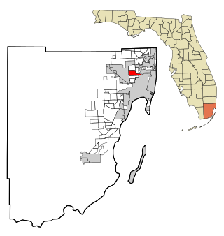
Country Club is a census-designated place and a suburban unincorporated community located in northwest Miami-Dade County, Florida, United States. It is located in the Miami metropolitan area of South Florida. The CDP is named after the Country Club of Miami, which was established in 1961 in what was then an unpopulated and undeveloped section of the county. The population was 49,967 at the 2020 census, up from 3,408 in 1990.

<span class="mw-page-title-main">Gladeview, Florida</span> Census-designated place in Florida

Gladeview is a census-designated place (CDP) in Miami-Dade County, Florida, United States. It is part of the Miami metropolitan area of South Florida. The population was 14,927 at the 2020 census, up from 11,535 in 2010.

<span class="mw-page-title-main">Goulds, Florida</span> Census-designated place in Florida

Goulds is an unincorporated community and census-designated place (CDP) in Miami-Dade County, Florida, United States. The area was originally populated as the result of a stop on the Florida East Coast Railroad. The railroad depot was located near the current Southwest 224th Street. The community was named after its operator, Lyman Gould, who cut trees for railroad ties. It is part of the Miami metropolitan area of South Florida. As of the 2020 US census, the population stood at 11,446, up from 10,103 in 2010 US census.

<span class="mw-page-title-main">Homestead Base, Florida</span> Census-designated place in Florida

Homestead Base is a census-designated place (CDP) in Miami-Dade County, Florida, United States. The CDP comprises the extent of Homestead Air Reserve Base plus some surrounding land. It is part of the Miami metropolitan area of South Florida. The population was 999 at the 2020 census.

<span class="mw-page-title-main">Leisure City, Florida</span> Census-designated place in Florida

Leisure City is an unincorporated community and census-designated place (CDP) in Miami-Dade County, Florida, United States, that includes the smaller, older community of Modello in its northwestern section. The CDP is most notable for the Coral Castle Museum, located in the Modello area. It is located in the Miami metropolitan area of South Florida. The population was 26,324 at the 2020 census, up from 22,655 in 2010.

<span class="mw-page-title-main">Palmetto Estates, Florida</span> Census-designated place in Florida

Palmetto Estates is an unincorporated area and census-designated place (CDP) in Miami-Dade County, Florida, United States. It is part of the Miami metropolitan area of South Florida. The population was 13,498 at the 2020 census.

<span class="mw-page-title-main">Pinewood, Florida</span> Census-designated place in Florida

Pinewood is an unincorporated community and census-designated place (CDP) in Miami-Dade County, Florida, United States. It is part of the Miami metropolitan area of South Florida. The population was 17,246 at the 2020 census.

<span class="mw-page-title-main">Princeton, Florida</span> Census-designated place in Florida

Princeton is a census-designated place (CDP) and unincorporated community in Miami-Dade County, Florida, United States. It is part of the Miami metropolitan area of South Florida. The population was 39,208 at the 2020 census, up from 22,038 at the 2010 census.

<span class="mw-page-title-main">Richmond West, Florida</span> Census-designated place in Florida

Richmond West is a census-designated place (CDP) in Miami-Dade County, Florida, United States. It is part of the Miami metropolitan area of South Florida. The population was 35,884 at the 2020 census, up from 31,973 at the 2010 census.

<span class="mw-page-title-main">West Little River, Florida</span> CDP in Miami-Dade County, Florida, US

West Little River is a census-designated place (CDP) in Miami-Dade County, Florida, United States. It is part of the Miami metropolitan area of South Florida. The population was 34,128 at the 2020 census.

<span class="mw-page-title-main">West Perrine, Florida</span> Census-designated place in Florida

West Perrine is a census-designated place (CDP) in Miami-Dade County, Florida, United States. It is part of the Miami metropolitan area of South Florida. The population was 10,602 at the 2020 census, up from 9,460 in 2010.

<span class="mw-page-title-main">Niceville, Florida</span> City in Florida, United States

Niceville is a city in Okaloosa County, Florida, United States, located near Eglin Air Force Base on Boggy Bayou that opens into Choctawhatchee Bay. It is part of the Fort Walton Beach–Crestview–Destin Metropolitan Statistical Area. The population was 15,772 at the 2020 census.

<span class="mw-page-title-main">Meadow Woods, Florida</span> Census-designated place in Florida, United States

Meadow Woods is a census-designated place (CDP) and an unincorporated suburban development area located in southern Orange County, Florida, United States, between Orlando International Airport and Kissimmee. It is part of the Orlando–Kissimmee–Sanford, Florida Metropolitan Statistical Area. As of 2020, the population was 43,790.

<span class="mw-page-title-main">Safety Harbor, Florida</span> City in Florida, United States of America

Safety Harbor is a city on the west shore of Tampa Bay in Pinellas County, Florida, United States. It was settled in 1823 and incorporated in 1917. The population was 17,072 at the 2020 census.

<span class="mw-page-title-main">Auburndale, Florida</span> City in Florida, United States of America

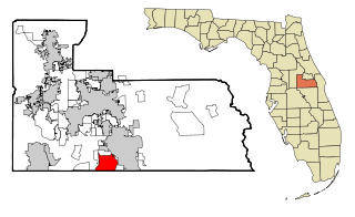
Auburndale is a city in Polk County, Florida, United States. It is part of the Lakeland-Winter Haven, Florida Metropolitan Statistical Area. The population was 15,616 at the 2020 census.

References

  1. "2020 U.S. Gazetteer Files". United States Census Bureau. Retrieved December 2, 2021.
  2. 1 2 "U.S. Census website". United States Census Bureau . Retrieved January 31, 2008.
  3. "US Board on Geographic Names". United States Geological Survey. October 25, 2007. Retrieved January 31, 2008.
  4. "Sumter County". Jim Forte Postal History. Retrieved November 1, 2015.
  5. Blackstone, Lillian (March 23, 1952). "Into center of state". St. Petersburg Times. p. 19. Retrieved November 1, 2015.
  6. "The Villages withdraws plan for 800 new homes in Wildwood". Villages-News. April 28, 2015. Retrieved April 28, 2015.
  7. "US Gazetteer files: 2010, 2000, and 1990". United States Census Bureau. February 12, 2011. Retrieved April 23, 2011.
  8. "Census of Population and Housing". Census.gov. Retrieved June 4, 2015.
  9. "P2 HISPANIC OR LATINO, AND NOT HISPANIC OR LATINO BY RACE - 2010: DEC Redistricting Data (PL 94-171) - Wildwood city, Florida". United States Census Bureau .
  10. "P2 HISPANIC OR LATINO, AND NOT HISPANIC OR LATINO BY RACE - 2020: DEC Redistricting Data (PL 94-171) - Wildwood city, Florida". United States Census Bureau .
  11. "S1101 HOUSEHOLDS AND FAMILIES - 2020: Wildwood city, Florida". United States Census Bureau .
  12. "S1101 HOUSEHOLDS AND FAMILIES - 2010: Wildwood city, Florida". United States Census Bureau .
  13. http://www.trainweb.org/usarail/wildwood.htm Wildwood Amtrak Station (USA RailGuide -- TrainWeb)
  14. Seaboard Coast Line Railroad timetable, December 15, 1967, Tables 18, 20