
The United States Virgin Islands (USVI) is the only place under United States jurisdiction where the rule of the road is to drive on the left. However, virtually all passenger vehicles are left hand drive due to imports of U.S. vehicles.
The United States Virgin Islands (USVI) is the only place under United States jurisdiction where the rule of the road is to drive on the left. However, virtually all passenger vehicles are left hand drive due to imports of U.S. vehicles.
Cars drive on the left hand side of the road, but nearly all the automobiles on the island have left-side steering columns. Due to the terrain, roads are often narrow, steep, and take with sharp turns. They tend to be poorly surfaced.
The USVI have 1,230 mi (1,980 km) of roadways, about 750 mi (1,210 km) of public roads and 490 mi (790 km) of private roads. Most public roads are two-lane and are paved with asphalt or concrete. There are few shoulders. Guts (culverts) and retaining walls help prevent flooding and landslides. Private roads are often unpaved or semi-paved. [1]

Virgin Islands Transit (VITRAN) public buses run between the main towns and areas of local interest (not tourist destinations). Bus fare is $1 or less. [2] [3] Privately owned "dollar ride" or "dollar run" taxi buses stop at or near many bus stops. They follow a predefined route, but do not follow a regular schedule. It is often possible to get off anywhere along their route. These buses charge a flat rate for the trip, either $1 or $2. [4]


Nearly all taxis are shared taxis, either enclosed vans or open-air "safaris", that go to destinations that are most convenient for tourists (e.g., hotels, beaches, docks, airports, sightseeing tours). They are not metered and are required by law to charge a flat fare that varies by destination. However, private taxis can be booked online to avoid delays or shared space. [5] [6]
Many flights connect the islands to the U.S. mainland. Flights also operate between Saint Thomas and Saint Croix, and from both of them to other islands in the Caribbean.
Two international airports serve the islands: [7]
There are no airports on Saint John or Water Island.
There are also two seaplane bases:
About two million people visit the U.S. Virgin Islands by cruise ship each year. [7]
On Saint Thomas, large cruise ships dock at the West Indian Company Dock (WICO), Havensight and the Austin "Babe" Monsanto Marine Facility in Crown Bay (Subbase). Cruise ships can also anchor in the Charlotte Amalie Harbor and tender to Waterfront; mini-cruise ships can dock at the Waterfront. [8]
On Saint Croix, cruise ships arrive at the Ann E. Abramson Marine Facility in Frederiksted. Mini-cruise ships can also dock at Gallows Bay near Christiansted. [8]
The two main ferry terminals on Saint Thomas are The Edward Wilmoth Blyden IV Marine Terminal in Charlotte Amalie and the Urman Victor Fredericks Marine Terminal in Red Hook. [1]
The ferry terminal for Saint Croix is at The Gallows Bay Dock. [1]
On Saint John, passenger ferries enter at The Loredon Lawrence Boynes Sr. Dock while The Theovald Eric Moorehead Dock and Terminal at Enighed Pond.[ clarification needed ] [1]
Water Island has a small dock at Phillips Landing. [10]
There are many and frequent inter-island ferries. Cruz Bay, Saint John can be reached from Charlotte Amalie and Red Hook on Saint Thomas. Car barges also run between Cruz Bay and Red Hook. Water Island can be reached from Crown Bay, Saint Thomas. There is a once daily ferry between Charlotte Amalie and Gallows Bay, Saint Croix. International ferries also run between Saint Thomas, Saint John, and the neighboring British Virgin Islands. [10]
On Saint Thomas, cargo vessels are served by the Crown Bay Cargo Port. [8]
On Saint Croix, cargo vessels are served by The Gallows Bay Dock near Christiansted and the Wilfred "Bomba" Allick Port and Transshipment Center (Containerport) in Krause Lagoon. [8]
On Saint John, cargo vessels are served by the Victor William Sewer Marine Facility (The Creek) and the Theovald Eric Moorehead Dock and Terminal. [8]
There are numerous marinas and anchorages in the USVI. Vessels entering the islands must proceed directly to a port of entry for clearance before passengers and crew go ashore. [11]
Additional ports, marinas, and anchorage sites include:
Although a U.S. territory, the USVI are maintained as a "free port" in a separate customs zone. Travelers to the continental United States and Puerto Rico need to pre-clear U.S. customs and present a passport or proof of U.S. citizenship or nationality. The immigration status of non-U.S. citizens may be checked during this process as well.
Transport in Saint Christopher and Nevis includes normal road traffic, public buses, taxis, ferries, airports, and one railway.

The United States Virgin Islands are a group of several dozen islands and cays located in the Caribbean, about 1,100 miles (1,770 km) southeast of Florida, 600 miles (966 km) north of Venezuela, 40 miles (64 km) east of Puerto Rico, and immediately west and south of the British Virgin Islands.

Politics of the United States Virgin Islands takes place in a framework of a presidential representative democratic dependency, whereby the Governor is the head of the territory's government, and of a multi-party system. United States Virgin Islands are an unincorporated and organized territory of the United States, administered by the Office of Insular Affairs of the United States Department of the Interior. Executive power is exercised by the local government of the Virgin Islands. The judiciary is independent of the executive and the legislature.

Basseterre is the capital and largest city of Saint Kitts and Nevis with an estimated population of 14,000 in 2018. Geographically, the Basseterre port is located at 17°18′N62°44′W, on the south western coast of Saint Kitts Island, and it is one of the chief commercial depots of the Leeward Islands. The city lies within Saint George Basseterre Parish.

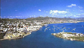
Charlotte Amalie, located on St. Thomas, is the capital and the largest city of the United States Virgin Islands. It was founded in 1666 as Taphus. In 1691, the town was renamed to Charlotte Amalie after the Danish queen Charlotte Amalie of Hesse-Kassel (1650–1714). It has a deep-water harbor that was once a haven for pirates and is now one of the busiest ports of call for cruise ships in the Caribbean, with about 1.5 million-plus cruise ship passengers landing there annually. Protected by Hassel Island, the harbor has docking and fueling facilities, machine shops, and shipyards and was a U.S. submarine base until 1966. The Town has been inhabited for centuries. When Christopher Columbus arrived in 1493, the area was inhabited by Caribs, Arawaks, Ciboney and Taíno native peoples. It is on the southern shore at the head of Saint Thomas Harbor. In 2010 the City had a population of 18,481, which makes it the largest city in the Virgin Islands Archipelago. Hundreds of ferries and yachts pass by the Town each week.
Saint Croix is an island in the Caribbean Sea, and a county and constituent district of the United States Virgin Islands (USVI), an unincorporated territory of the United States.

Saint Thomas is one of the Virgin Islands in the Caribbean Sea, and a constituent district of the United States Virgin Islands (USVI), an unincorporated territory of the United States. Along with surrounding minor islands, it is one of three county-equivalents in the USVI. Together with Saint John, it forms one of the districts of the USVI. The territorial capital and port of Charlotte Amalie is located on the island.

Saint John is one of the Virgin Islands in the Caribbean Sea and a constituent district of the United States Virgin Islands (USVI), an unincorporated territory of the United States.

Road Town, located on Tortola, is the capital and largest town of the British Virgin Islands. It is situated on the horseshoe-shaped Road Harbour in the centre of the island's south coast. The population was about 15,000 in 2018.
Christiansted is the largest town on Saint Croix, one of the main islands composing the United States Virgin Islands, a territory of the United States of America. The town is named after King Christian VI of Denmark.
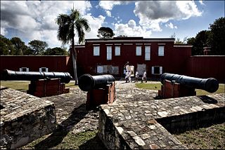
Frederiksted is both a town and one of the two administrative districts of St. Croix, U.S. Virgin Islands. It is a grid-planned city, designed by surveyor Jens Beckfor, originally to 14x14 blocks but built 7x7 to enhance the island commerce in the 1700s. Fewer than 1,000 people live in Frederiksted proper, but nearly 10,000 live on the greater western side of the island. Christiansted is about 30 years older, but commerce was limited by its natural, shallow protective reef. Frederiksted was built in the leeward side of the island for calm seas and a naturally deep port. It is home to Fort Frederik, constructed to protect the town from pirate raids and attacks from rival imperialist nations and named after Frederick V of Denmark, who purchased the Danish West Indies in 1754.

Cyril E. King Airport is a public airport located two miles (3 km) west of the central business district of Charlotte Amalie on the island of St. Thomas in the United States Virgin Islands. It is currently the busiest airport in the United States Virgin Islands, and one of the busiest in the eastern Caribbean, servicing 1,403,000 passengers from July 2015 through June 2016. The airport also serves the island of St. John and is additionally often used by those travelling to the nearby British Virgin Islands.
WTJX-TV is a PBS member television station serving the United States Virgin Islands that is licensed to Charlotte Amalie, Saint Thomas. Owned by the Virgin Islands Public Broadcasting System, it is sister to NPR member WTJX-FM (93.1 MHz). The two stations share studios on Haypiece Hill in Charlotte Amalie; WTJX-TV's transmitter is located on Signal Hill.
Charlotte Amalie Harbor Seaplane Base, also known as St. Thomas Seaplane Base, is located in the harbor by Charlotte Amalie, Saint Thomas, U.S. Virgin Islands. This private-use airport is owned by the Virgin Islands Port Authority.
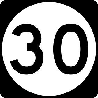
Highway 30 is a major road on St. Thomas, USVI.

The Frederiksted Pier is the 1,526-foot, deep water, cruise ship pier located in Frederiksted, U.S. Virgin Islands. It is located at the west end of Saint Croix, U.S. Virgin Islands and accommodate two Eagle-class vessels, of a maximum of 142,000 gross tons each with drafts up to 29 feet and two mini-cruise vessels with drafts of 18 feet. Anchorage is also available in the outer harbor for larger ships. The platform of the pier is equipped with a fendering system that is designed for submarines.

East End is an administrative subdistrict of the island of St. Thomas in the United States Virgin Islands. The largest community is Red Hook, while smaller communities include Benner, Nazareth, Nadir, Frydendal, and Smith Bay. The subdistrict includes the offshore islands of Great Saint James, Little Saint James, Bovoni Cay, Patricia Cay, Cas Cay, Rotto Cay, Thatch Cay, Shark Island, and Dog Island.

Shekou Cruise Center, also known as the Shekou Ferry Terminal and the Shekou Prince Bay Cruise Homeport, is a cruise terminal located in Shekou, Nanshan District, Shenzhen, China. It runs direct ferry connections from Shenzhen to destinations across the Pearl River Delta. It is operated by China Merchants Shekou Ferry Terminal Service Co., Ltd. Ferry operations are operated by Xunlong Ferries, TurboJET and CKS Ferries. It can also handle cruise ships docking and replenishment, and is the first cruise terminal in China. This facility replaces the former Shekou Passenger Terminal and is part of a larger urban renewal and redevelopment along Shenzhen Bay.

U.S. Virgin Islands Governor's Mansion may refer to any one of the three official residences owned by the government of the U.S. Virgin Islands and provided to the Governor of the United States Virgin Islands. One residence is located on each of the three largest inhabited islands of this U.S. territory in the Caribbean. The U.S. Virgin Islands maintains more official gubernatorial residences than any other state or territory of the United States.
