
Cruz Bay, U.S. Virgin Islands is the main town on the island of Saint John in the United States Virgin Islands. According to the 2000 census, Cruz Bay had a population of 2,743.
Cruz Bay, U.S. Virgin Islands is the main town on the island of Saint John in the United States Virgin Islands. According to the 2000 census, Cruz Bay had a population of 2,743.

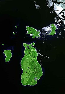
Cruz Bay, located on the west coast of Saint John, is the island's largest commercial center and the location of the main port on Saint John. The primary access to Saint John is through Cruz Bay Harbor. Frequent barge and ferry, including car ferry, service connects Saint John to the neighboring more-developed island of Saint Thomas. Ferries also run regularly between Cruz Bay and Tortola, Virgin Gorda, and Jost Van Dyke in the British Virgin Islands.
Cruz Bay is home to numerous shops and restaurants which are frequented by tourists and locals alike. The Virgin Islands National Park Visitor Center, the Elaine Sprauve Library, and a United States Post Office are also located in Cruz Bay.
Cruz Bay beach is lined with beach bars and shops. There is also a casino. The beach has soft white sand, a designated swimming area, and space for day boaters to anchor.
The National Park Service has its headquarters near the waterfront in Cruz Bay as does U.S. Customs and Immigration.
The Cruz Bay Town Historic District was listed on the U.S. National Register of Historic Places in 2016. [1]
According to the Köppen Climate Classification system, Cruz Bay has a tropical monsoon climate, abbreviated "Am" on climate maps. [2] On 31 July 1988, Cruz Bay recorded a temperature of 37.2 °C (99.0 °F), which is the highest temperature to have ever been recorded in the United States Virgin Islands. [3]
| Climate data for Cruz Bay, United States Virgin Islands | |||||||||||||
|---|---|---|---|---|---|---|---|---|---|---|---|---|---|
| Month | Jan | Feb | Mar | Apr | May | Jun | Jul | Aug | Sep | Oct | Nov | Dec | Year |
| Average high °F (°C) | 83.8 (28.8) | 84.0 (28.9) | 84.1 (28.9) | 84.9 (29.4) | 86.4 (30.2) | 88.0 (31.1) | 88.9 (31.6) | 89.2 (31.8) | 89.0 (31.7) | 88.2 (31.2) | 86.7 (30.4) | 84.6 (29.2) | 86.5 (30.3) |
| Average low °F (°C) | 69.6 (20.9) | 69.5 (20.8) | 69.7 (20.9) | 71.7 (22.1) | 74.0 (23.3) | 75.8 (24.3) | 75.9 (24.4) | 75.9 (24.4) | 75.1 (23.9) | 74.2 (23.4) | 72.7 (22.6) | 70.6 (21.4) | 72.9 (22.7) |
| Average precipitation inches (mm) | 2.7 (69) | 1.9 (48) | 2.0 (51) | 3.5 (89) | 4.0 (100) | 2.5 (64) | 3.3 (84) | 4.3 (110) | 6.0 (150) | 4.9 (120) | 6.3 (160) | 3.2 (81) | 44.7 (1,140) |
| Source: Weatherbase [4] | |||||||||||||


The United States Virgin Islands are a group of several dozen islands and cays located in the Caribbean, about 1,100 miles (1,770 km) southeast of Florida, 600 miles (966 km) north of Venezuela, 40 miles (64 km) east of Puerto Rico, and immediately west and south of the British Virgin Islands.

Newport Beach is a coastal city in South Orange County, California, United States. Newport Beach is known for swimming and sandy beaches. Newport Harbor once supported maritime industries, but today, it is used mostly for recreation. Balboa Island draws visitors with a waterfront path and easy access from the ferry to the shops and restaurants.

Watford City, founded in 1914, is a city in and the county seat of McKenzie County, North Dakota, United States. The population was 6,207 at the 2020 census, making it the thirteenth largest city in North Dakota. Because Watford City is part of the Bakken field, the North Dakota oil boom has significantly increased population and construction since the 2010 census.
Saint Croix is an island in the Caribbean Sea, and a county and constituent district of the United States Virgin Islands (USVI), an unincorporated territory of the United States.

Saint Thomas is one of the Virgin Islands in the Caribbean Sea which, together with Saint John, Water Island, Hassel Island, and Saint Croix, form a county-equivalent and constituent district of the United States Virgin Islands (USVI), an unincorporated territory of the United States. The territorial capital and port of Charlotte Amalie is located on the island. In the 2010 census, the population of Saint Thomas was 51,634, about 48.5% of the US Virgin Islands total. As of the 2020 census, the population of Saint Thomas is 42,461. The district has a land area of 32 square miles (83 km2).
Beaver Island is an island in Lake Michigan in the U.S. state of Michigan. At 55.8 sq mi (145 km2), it is the largest island in Lake Michigan and the third largest island in Michigan after Isle Royale and Drummond Island. The island is located approximately 32 miles (51 km) from the city of Charlevoix. Beaver Island had a total population of 657 at the 2010 census.

George Town is the capital and largest city in the Cayman Islands, located on Grand Cayman. As of 2021, the city had a population of 34,921, making it the largest city of all the British Overseas Territories.

Tamuning, also known as Tamuning-Tumon-Harmon is a village located on the western shore of the United States territory of Guam. The village of Tamuning is the economic center of Guam, containing tourist center Tumon, Harmon Industrial Park, and other commercial districts. Its central location along Marine Corps Drive, the island's main thoroughfare, has aided in its development.

Sooke is a district municipality on the southern tip of Vancouver Island, Canada, 38 kilometres (24 mi) by road from Victoria, the capital of British Columbia. Sooke, the westernmost of Greater Victoria's Western Communities, is to the north and west of the Sooke Basin.
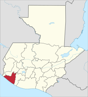
Retalhuleu is a department located in the south-west of Guatemala, extending from the mountains to the Pacific Ocean coast. It has an area of 1856 km². In 2018 the population of the Department of Retalhuleu was 326,828. Its capital, Retalhuleu City, mixes ancient and modern architecture, and it is also known for being a commercial city.

The Virgin Islands National Park is an American national park preserving about 60% of the land area of Saint John in the United States Virgin Islands, as well as more than 5,500 acres of adjacent ocean, and nearly all of Hassel Island, just off the Charlotte Amalie, Saint Thomas harbor.

Freeport is a city, district and free trade zone on the island of Grand Bahama of the northwest Bahamas. In 1955, Wallace Groves, a Virginian financier with lumber interests in Grand Bahama, was granted 20,000 hectares of pineyard with substantial areas of swamp and scrubland by the Bahamian government with a mandate to economically develop the area. Freeport has grown to become the second most populous city in the Bahamas.

Saint John is one of the Virgin Islands in the Caribbean Sea and a constituent district of the United States Virgin Islands (USVI), an unincorporated territory of the United States.

Diriamba is a city and a municipality in the Carazo department of Nicaragua, with a population of 64,757. It is located 41 km south of Managua, the capital of Nicaragua.
Key Vaca is an island in the middle Florida Keys, located entirely within the borders of the city of Marathon, Florida.

St. Mary is an unincorporated community on the western border of the Blackfeet Indian Reservation adjacent to Glacier National Park in Glacier County, Montana, United States. The village is the eastern terminus of the Going-to-the-Sun Road which bisects the park east to west, a distance of 53 mi (85 km).
Anna's Retreat is a town in the administrative subdistrict of Tutu in St. Thomas, U.S. Virgin Islands. As of 2006, the population was 7,600, making Anna's Retreat the second-largest town in the U.S. Virgin Islands after the territorial capital, Charlotte Amalie.

Marigot is the main town and capital in the French Collectivity of Saint Martin.

The climate of Los Angeles is mild to hot year-round, and mostly dry. It is classified as a Mediterranean climate, which is a type of dry subtropical climate. It is characterized by seasonal changes in rainfall—with a dry summer and a winter rainy season. Under the modified Köppen climate classification, the coastal areas are classified as Csb, and the inland areas as Csa.
Capurganá is a town of the municipality of Acandí on the northwestern coast of the Gulf of Urabá in the Colombian department of Chocó, adjacent to the border between Colombia and Panama. Previously a base site for eco-tourists, since 2010 the town's main source of income has been migrants preparing to hike into Panama, across the Darién Gap. In 2019 it was described as a "smugglers' town".
| General | |
|---|---|
| National libraries | |
| Other | |
