Glades County, Florida

Last updated

Glades County
Gladesctycourthousefl01.jpg
Glades County Courthouse
Map of Florida highlighting Glades County.svg
Location within the U.S. state of Florida
Florida in United States.svg
Florida's location within the U.S.
Coordinates: 26°57′N81°11′W / 26.95°N 81.19°W / 26.95; -81.19
CountryFlag of the United States.svg United States
StateFlag of Florida.svg  Florida
FoundedApril 23, 1921
Named for Florida Everglades
Seat Moore Haven
Largest cityMoore Haven
Area
  Total987 sq mi (2,560 km2)
  Land806 sq mi (2,090 km2)
  Water181 sq mi (470 km2)  18.3%
Population
 (2020)
  Total12,126
  Density16/sq mi (6/km2)
Time zone UTC−5 (Eastern)
  Summer (DST) UTC−4 (EDT)
Congressional district 17th
Website www.myglades.com

Glades County is a county located in the Florida Heartland region of the U.S. state of Florida. As of the 2020 census, the population was 12,126, [1] making it the fourth-least populous county in Florida. Its county seat is Moore Haven. [2]

Contents

Glades County is in the Clewiston micropolitan area, a Micropolitan statistical area (μSA) which also includes Hendry County. [3] These two counties, along with the Cape Coral-Fort Myers (Lee County) MSA and the Naples-Marco Island (Collier County) MSA, constitute the Cape Coral- Fort Myers- Naples Combined Statistical Area (CSA).

Awards

History

Indigenous people lived in this area for thousands of years. Due to warfare and exposure to infectious diseases after European contact, native tribes became depopulated. In the eighteenth century, when the area was under Spanish rule, Native American peoples of Creek and other tribes migrated into present-day Florida from Georgia. Africans and African Americans who escaped from slavery and shipwrecks also migrated to the area, where they created maroon communities. Some were given freedom by the Spanish in exchange for serving with their militias. Gradually the Seminole nation formed out of these multi-ethnic people. Some African-descended people set up communities near the Seminole and became known as Black Seminole. In the nineteenth century, most of the Seminole and many blacks were removed to Indian Territory after the Seminole Wars, a result of pressure from increasing Anglo-American settlement.

Glades County was created, in 1921, from Desoto County. It was named for the Florida Everglades, though most of the county is prairie and pinelands. [6]

It is one of five counties surrounding Lake Okeechobee and the Lake Okeechobee Scenic Trail.

Glades County sponsors one of Florida's oldest recurring festivals. Chalo Nitka Festival is a celebration of local history and culture, similar to a county fair. The festival also draws attention to the long and friendly relationship between the local Seminole groups and Glades County settlers. Brighton Seminole Indian Reservation is located in the county.

Geography

According to the U.S. Census Bureau, the county has a total area of 987 square miles (2,560 km2), of which 806 square miles (2,090 km2) is land and 181 square miles (470 km2) (18.3%) is water. [7]

Fisheating Creek is a stream that flows into Lake Okeechobee in Florida. It is the only remaining free-flowing watercourse feeding into the lake and the second-largest natural source for the lake.

Glades was added to the Clewiston micropolitan area (μSA) in July 2023. [8]

Adjacent counties

Climate

Climate data for Glades County, Florida (1980-2010)
MonthJanFebMarAprMayJunJulAugSepOctNovDecYear
Mean daily maximum °F (°C)73.7
(23.2)
76.3
(24.6)
80.0
(26.7)
84.1
(28.9)
89.3
(31.8)
91.1
(32.8)
91.8
(33.2)
91.8
(33.2)
90.1
(32.3)
86.1
(30.1)
80.2
(26.8)
75.1
(23.9)
84.1
(29.0)
Mean daily minimum °F (°C)47.8
(8.8)
50.9
(10.5)
54.6
(12.6)
58.0
(14.4)
64.6
(18.1)
70.2
(21.2)
71.8
(22.1)
72.4
(22.4)
71.4
(21.9)
65.2
(18.4)
57.3
(14.1)
51.1
(10.6)
61.3
(16.3)
Average precipitation inches (mm)1.9
(48)
2.5
(64)
3.3
(84)
2.3
(58)
3.3
(84)
8.6
(220)
7.7
(200)
7.9
(200)
6.7
(170)
2.7
(69)
2.0
(51)
1.9
(48)
50.8
(1,296)
Source: USA.com [9]

Demographics

Historical population
CensusPop.Note
1930 2,762
1940 2,745−0.6%
1950 2,199−19.9%
1960 2,95034.2%
1970 3,66924.4%
1980 5,99263.3%
1990 7,59126.7%
2000 10,57639.3%
2010 12,88421.8%
2020 12,126−5.9%
2023 (est.)12,786 [10] 5.4%
U.S. Decennial Census [11]
1790-1960 [12] 1900-1990 [13]
1990-2000 [14] 2010-2019 [1]
Glades County racial composition as of 2020
(NH = Non-Hispanic) [lower-alpha 1]
RacePop 2010 [17] Pop 2020 [18] % 2010% 2020
White (NH)7,9477,13261.68%58.82%
Black or African American (NH)1,5381,43411.94%11.83%
Native American or Alaska Native (NH)5181934.02%1.59%
Asian (NH)46340.36%0.28%
Pacific Islander (NH)200.02%0.0%
Some Other Race (NH)10450.08%0.37%
Mixed/Multi-Racial (NH)1032380.8%1.96%
Hispanic or Latino 2,7203,05021.11%25.15%
Total12,88412,126

As of the 2020 United States census, there were 12,126 people, 4,859 households, and 3,247 families residing in the county.

As of the census [19] of 2000, there were 10,576 people, 3,852 households, and 2,765 families residing in the county. The population density was 14 people per square mile (5.4 people/km2). There were 5,790 housing units at an average density of 8 per square mile (3.1/km2). The racial makeup of the county was 76.99% White, 10.53% Black or African American, 4.93% Native American, 0.33% Asian, 0.02% Pacific Islander, 5.63% from other races, and 1.58% from two or more races. 15.07% of the population were Hispanic or Latino of any race.

In 2005 the population was 67.0% non-Hispanic white, 17.6% Latino, 10.5% African-American and 4.9% Native American. [20]

There were 3,852 households, out of which 25.80% had children under the age of 18 living with them, 58.30% were married couples living together, 8.60% had a female householder with no husband present, and 28.20% were non-families. 22.70% of all households were made up of individuals, and 11.40% had someone living alone who was 65 years of age or older. The average household size was 2.51 and the average family size was 2.91.

In the county, the population was spread out, with 22.10% under the age of 18, 7.60% from 18 to 24, 27.00% from 25 to 44, 24.50% from 45 to 64, and 18.80% who were 65 years of age or older. The median age was 40 years. For every 100 females, there were 121.50 males. For every 100 females age 18 and over, there were 125.40 males.

The median income for a household in the county was $30,774, and the median income for a family was $34,223. Males had a median income of $29,196 versus $20,987 for females. The per capita income for the county was $15,338. About 10.70% of families and 15.20% of the population were below the poverty line, including 18.20% of those under age 18 and 11.20% of those age 65 or over.

Education

Politics

United States presidential election results for Glades County, Florida [23]
Year Republican Democratic Third party
No.%No.%No.%
2020 3,78272.69%1,38526.62%360.69%
2016 2,99668.37%1,27129.01%1152.62%
2012 2,34458.54%1,60340.03%571.42%
2008 2,53359.45%1,67439.29%541.27%
2004 2,44358.33%1,71841.02%270.64%
2000 1,84154.71%1,44242.85%822.44%
1996 1,36139.67%1,53044.59%54015.74%
1992 1,18535.12%1,30538.68%88426.20%
1988 1,54759.66%1,03439.88%120.46%
1984 1,98765.00%1,07035.00%00.00%
1980 1,09845.96%1,20350.36%883.68%
1976 62431.76%1,31166.72%301.53%
1972 1,01978.81%25319.57%211.62%
1968 26123.92%23021.08%60055.00%
1964 54155.09%44144.91%00.00%
1960 31444.35%39455.65%00.00%
1956 30947.69%33952.31%00.00%
1952 26439.70%40160.30%00.00%
1948 15027.03%27449.37%13123.60%
1944 16430.54%37369.46%00.00%
1940 18027.95%46472.05%00.00%
1936 23531.00%52369.00%00.00%
1932 14821.89%52878.11%00.00%
1928 33153.73%28145.62%40.65%
1924 8323.92%21261.10%5214.99%

Voter registration

According to the Secretary of State's office, Republicans are a majority of registered voters in Glades County.

Glades County Voter Registration & Party Enrollment as of July 31, 2022 [24]
Political PartyTotal VotersPercentage
Republican 3,50650.88%
Democratic 1,95928.43%
No party affiliation1,30318.91%
Minor parties1221.77%
Total6,890100.00%

Energy and environment

Florida Public Service Commission voted unanimously to deny a request by Florida Power and Light to build a huge coal-fired power plant in Glades County, that was to be located several miles to the west of Lake Okeechobee. [25] The Glades County Commission also allowed the construction in 2007 of a 200-acre (0.81 km2) landfill on the southwest shore of Lake Okeechobee.

Libraries

Glades County is part of the Heartland Library Cooperative which serves Glades County and some of the surrounding counties, including Okeechobee, Highlands, Hardee, and DeSoto. The seven-branch library system has one branch in Moore Haven.

Communities

Indian reservation

County Seat

Census-designated places

Other unincorporated communities

Memorials

See also

Notes

  1. Note: the US Census treats Hispanic/Latino as an ethnic category. This table excludes Latinos from the racial categories and assigns them to a separate category. Hispanics/Latinos can be of any race. [15] [16]

Related Research Articles

<span class="mw-page-title-main">Collier County, Florida</span> County in Florida, United States

Collier County is a county in the U.S. state of Florida. As of the 2020 census, its population was 375,752; an increase of 16.9% since the 2010 United States Census. Its county seat is East Naples, where the county offices were moved from Everglades City in 1962.

<span class="mw-page-title-main">DeSoto County, Florida</span> County in Florida, United States

DeSoto County is a county located in the Florida Heartland region of the U.S. state of Florida. As of the 2020 census, the population was 33,976. Its county seat is Arcadia.

<span class="mw-page-title-main">Hardee County, Florida</span> County in Florida, United States

Hardee County is a county located in the Florida Heartland of the Central Florida region in the U.S. state of Florida. As of the 2020 census, the population was 25,327. Its county seat is Wauchula.

<span class="mw-page-title-main">Hendry County, Florida</span> County in Florida, United States

Hendry County is a county in the Florida Heartland region of the U.S. state of Florida. As of the 2020 census, the population was 39,619, down from 42,022 at the 2010 census. Its county seat is LaBelle.

<span class="mw-page-title-main">Highlands County, Florida</span> County in Florida, United States

Highlands County is a county located in the Florida Heartland region of the U.S. state of Florida. As of the 2020 census, the population was 101,235. Its county seat is Sebring.

<span class="mw-page-title-main">Indian River County, Florida</span> County in Florida, United States

Indian River County is a county located in the southeastern and east-central portions of the U.S. state of Florida. As of the 2020 census, the population was 159,788. Its seat is Vero Beach. It is Florida's 7th richest county and in 2000 was the 87th richest county in the U.S. by per capita income.

<span class="mw-page-title-main">Okeechobee County, Florida</span> County in Florida, United States

Okeechobee County is a county located in the Florida Heartland region of the state of Florida. As of the 2020 census, the population was 39,644. The county seat is Okeechobee.

<span class="mw-page-title-main">Polk County, Florida</span> County in Florida

Polk County is located in the central portion of the U.S. state of Florida. The county population was 725,046, as of the 2020 census, and estimated to be 818,330, as of July 1, 2023. Its county seat is Bartow, and its largest city is Lakeland.

<span class="mw-page-title-main">Sumter County, Florida</span> County in Florida, United States

Sumter County is a county located in the central portion of the U.S. state of Florida. As of the 2020 census, the population is 129,752. It has the oldest median age of any US county and the highest percentage of residents aged 65 and older—at 55.6% in 2014–2018. Its county seat is Bushnell, and the largest city is Wildwood. Although the community of The Villages has more residents, it is a part of unincorporated Sumter County.

<span class="mw-page-title-main">Everglades City, Florida</span> City in Florida

Everglades City is a city in Collier County, Florida, United States, of which it was once the county seat. The City of Everglades City is part of the Naples–Marco Island Metropolitan Statistical Area, which is included in the Cape Coral-Fort Myers-Naples Combined Statistical Area. The Gulf Coast Visitor Center for Everglades National Park is located in Everglades City. As of the 2020 US census, the population was 352, down from 400 in the 2010 US census.

<span class="mw-page-title-main">Buckhead Ridge, Florida</span> CDP in Florida, United States

Buckhead Ridge is a census-designated place (CDP) in Glades County, Florida, United States. The population was 1,509 at the 2020 census, up from 1,450 at the 2010 census. It is part of the Clewiston, Florida Micropolitan Statistical Area (μSA). The community consists of a few small commercial developments and a large mobile home park. Most residential lots in the community abut canals that feed into Lake Okeechobee.

<span class="mw-page-title-main">Moore Haven, Florida</span> City in Florida, United States

Moore Haven is a city in, and the county seat of, Glades County, Florida, United States. It is part of the Florida Heartland region. The population was 1,566 at the 2020 census, down from 1,680 at the 2010 census. Moore Haven is located on the southwest shoreline of Lake Okeechobee. It is part of the Clewiston, Florida Micropolitan Statistical Area (μSA).

<span class="mw-page-title-main">Clewiston, Florida</span> City in Florida, United States

Clewiston is a city in Hendry County, Florida, United States. Its location is 80 miles (130 km) northwest of Fort Lauderdale on the Atlantic coastal plain. The population was 7,327 at the 2020 census, up from 7,155 at the 2010 census. It is the principal city in the Clewiston, Florida Micropolitan Statistical Area (μSA).

<span class="mw-page-title-main">Port LaBelle, Florida</span> Census-designated place in Florida, United States

Port LaBelle is a census-designated place (CDP) in Hendry and Glades counties, Florida, United States. The population was 5,450 at the 2020 census, up from 3,530 at the 2010 census. It is part of the Clewiston, Florida Micropolitan Statistical Area (μSA).

<span class="mw-page-title-main">Okeechobee, Florida</span> City in Florida, United States

Okeechobee is a city in and the county seat of Okeechobee County, Florida, United States. As of the 2020 US census, the city's population was 5,254.

<span class="mw-page-title-main">Canal Point, Florida</span> CDP in Florida, United States

Canal Point is a census-designated place (CDP) and unincorporated community in Palm Beach County, Florida, United States. It is part of the Miami metropolitan area of South Florida despite its local culture and location being way more similar to the Florida Heartland. Canal Point has a population of 344 people counted in the 2020 US census.

<span class="mw-page-title-main">Lake Harbor, Florida</span> CDP in Florida, United States

Lake Harbor is a census-designated place (CDP) in Palm Beach County, Florida, United States. It is part of the Miami metropolitan area of South Florida despite being physically and culturally closer to the Florida Heartland. The population was 49 at the 2020 US census.

<span class="mw-page-title-main">Miami metropolitan area</span> Metropolis in the U.S. state of Florida

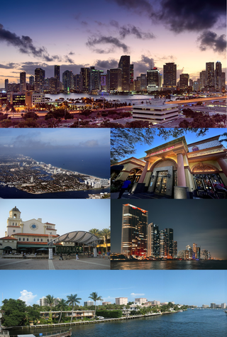
The Miami metropolitan area, also known as South Florida, SoFlo, SoFla, the Gold Coast, the Tri-County Area, or Greater Miami, and officially the Miami–Fort Lauderdale–West Palm Beach Metropolitan Statistical Area, is a coastal metropolitan area in southeastern Florida. It is the ninth-largest metropolitan statistical area (MSA) in the United States, the fifth-largest metropolitan area in the Southern United States, and the largest metropolitan area in Florida. With a population of 6.18 million, its population exceeds 31 of the nation's 50 states as of 2023. It comprises the three most populated counties in the state, Miami-Dade County, Broward County, and Palm Beach County, which rank as the first, second, and third-most populous counties in the state, respectively. Miami-Dade County, with 2,701,767 people in 2020, is the seventh-most populous county in the United States.

<span class="mw-page-title-main">Florida Heartland</span> Region in Florida

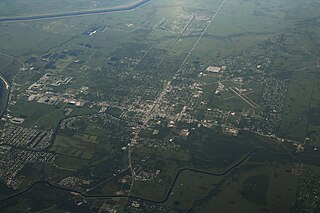
The Florida Heartland is a region of Florida located to the north and west of Lake Okeechobee, composed of six inland, non-metropolitan counties—DeSoto, Glades, Hardee, Hendry, Highlands, and Okeechobee. In 2000, The US Census Bureau recorded the population of the region at 229,509. In 2010, The US Census Bureau recorded the population of the region at 253,399, a growth rate of 11.0%. The most populous county in the region is Highlands County, and the region's largest cities are Avon Park and Sebring, both with slightly more than 10,000 people. Unlike the coastal areas to the east and west, the rural nature of the Florida Heartland is culturally closer to the Deep South than the rest of South Florida and has traditionally been inhabited by Americans of predominantly English ancestry. While located in Palm Beach County, the nearby rural cities of South Bay, Belle Glade and Pahokee as well as the census-designated place of Lake Harbor, located on the southeastern shore of Lake Okeechobee, are more associated with the Florida Heartland than the remainder of South Florida. The same could also apply to the Collier County communities of Immokalee, Ave Maria and Harker as well as to the Martin County community of Port Mayaca. Occasionally included are the southern Polk County communities of Fort Meade, Frostproof and River Ranch as well as Yeehaw Junction in Osceola County.

<span class="mw-page-title-main">LaBelle, Florida</span> City in Florida, United States

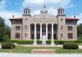
LaBelle is a city in and the county seat of Hendry County, Florida, United States. The population was 4,966 at the 2020 census, up from 4,640 at the 2010 census. It is part of the Clewiston, FL Micropolitan Statistical Area (μSA).

References

  1. 1 2 "State & County QuickFacts". United States Census Bureau. Archived from the original on June 7, 2011. Retrieved February 12, 2014.
  2. "Find a County". National Association of Counties. Archived from the original on May 31, 2011. Retrieved June 7, 2011.
  3. "Revised Delineations of Metropolitan Statistical Areas, Micropolitan Statistical Areas, and Guidance on the Uses of the Delineations of These Areas" (PDF). Executive Office of the President. July 21, 2023. p. 91. Retrieved July 27, 2023.
  4. Kinner, Derek L. (January 25, 2003). "Pool Effort Makes a Big Splash". The Florida Times Union.
  5. Browne, Don (October 6, 2014). "Muse Community Recognized For Fire Prevention Efforts". Southwest Florida Online - Sunday Morning News.
  6. "Florida Memory: History of Glades County". Florida Memory. 1939.
  7. "US Gazetteer files: 2010, 2000, and 1990". United States Census Bureau. February 12, 2011. Retrieved April 23, 2011.
  8. "Revised Delineations of Metropolitan Statistical Areas, Micropolitan Statistical Areas, and Guidance on the Uses of the Delineations of These Areas" (PDF). Executive Office of the President. July 21, 2023. p. 91. Retrieved July 27, 2023.
  9. "Climatological Information for Glades County, Florida", USA.com, 2003. Web: .
  10. "Annual Estimates of the Resident Population for Counties: April 1, 2020 to July 1, 2023". United States Census Bureau. Retrieved March 31, 2024.
  11. "U.S. Decennial Census". United States Census Bureau. Retrieved June 13, 2014.
  12. "Historical Census Browser". University of Virginia Library. Retrieved June 13, 2014.
  13. "Population of Counties by Decennial Census: 1900 to 1990". United States Census Bureau. Retrieved June 13, 2014.
  14. "Census 2000 PHC-T-4. Ranking Tables for Counties: 1990 and 2000" (PDF). United States Census Bureau. Retrieved June 13, 2014.
  15. https://www.census.gov/ [ not specific enough to verify ]
  16. "About the Hispanic Population and its Origin". www.census.gov. Retrieved May 18, 2022.
  17. "Explore Census Data". data.census.gov. Retrieved May 27, 2022.
  18. "Explore Census Data". data.census.gov. Retrieved May 27, 2022.
  19. "U.S. Census website". United States Census Bureau . Retrieved May 14, 2011.
  20. Source: https://web.archive.org/web/20110607002848/http://quickfacts.census.gov/qfd/states/12/12043.html
  21. 1 2 3 4 "Glades County School District". Glades County School District. Retrieved October 1, 2018.
  22. "Pemayetv Emahakv Charter School". Pemayetv Emahakv Charter School.
  23. Leip, David. "Dave Leip's Atlas of U.S. Presidential Elections". uselectionatlas.org.
  24. "Voter Registration - By County and Party". www.dos.myflorida.com. Retrieved August 22, 2022.
  25. "Coal Plant Near Everglades Denied :: Sierra Club". Archived from the original on October 10, 2008. Retrieved September 11, 2008.
  26. "Jim J. Greer - Muse, Florida, USA - Specific Veteran Memorials".

Government links/Constitutional offices

Special districts

Judicial branch

26°57′N81°11′W / 26.95°N 81.19°W / 26.95; -81.19