
The Forgotten Coast refers to a largely undeveloped and sparsely populated coastline in the panhandle of the US state of Florida. The trademarked term was first used in 1992, but the Forgotten Coast's exact extent is not agreed upon.
The Forgotten Coast refers to a largely undeveloped and sparsely populated coastline in the panhandle of the US state of Florida. The trademarked term was first used in 1992, but the Forgotten Coast's exact extent is not agreed upon.
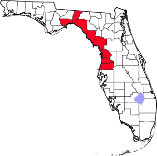
The Forgotten Coast is a trademark first used by the Apalachicola Bay Chamber of Commerce on September 1, 1992. [1] The name is most commonly used to refer to a relatively quiet, undeveloped and sparsely populated section of coastline stretching from Mexico Beach on the Gulf of Mexico to St. Marks on Apalachee Bay in the U.S. state of Florida. [2] The nearest major cities are Tallahassee, about 90 miles northeast of Apalachicola, and Panama City, home of Tyndall Air Force Base, about 60 miles to the northwest.
The Tourist Development Council of Franklin County defines the Forgotten Coast as Franklin County itself. They add that the Forgotten Coast got its name "because it’s the last remaining stretch of unspoiled, pristine Gulf Coast beaches that haven’t been overrun by high rises and strip malls." [3] In the council's definition of the Forgotten Coast, there are 200 miles of coastline, 5 islands, and nearly 100 historic sites, and it is a part of the Big Bend geographic region. [3]
In addition to the endpoints, it encompasses the coastal communities of (west to east):
These communities are located in the following counties, which by extension may be included in references to the Forgotten Coast by some writers:
The area is renowned for its oyster and shrimp production, marine wildlife, and fine white-sand beaches. Peninsulas and barrier islands along the coast include:
Protected natural and historic areas include:

Franklin County is a county along the Gulf of Mexico in the panhandle of the U.S. state of Florida. As of the 2020 census, the population was 12,451, making it the third-least populous county in Florida. The county seat is Apalachicola.

Wakulla County is a county located in the Big Bend region in the northern portion of the U.S. state of Florida. As of the 2020 census, the population was 33,764. Its county seat is Crawfordville.

St. Marks is a city in Wakulla County, Florida, United States. It is part of the Tallahassee metropolitan area. St. Marks is located on the Florida Panhandle in North Florida, along the Gulf of Mexico. As of 2020, the population according to the U.S. Census Bureau is 274.

The Florida panhandle is the northwestern part of the U.S. state of Florida. It is a salient roughly 200 miles (320 km) long, bordered by Alabama on the north and the west, Georgia on the north, and the Gulf of Mexico to the south. Its eastern boundary is arbitrarily defined. It is defined by its southern culture and rural geography relative to the rest of Florida, as well as closer cultural links to French-influenced Louisiana, Mississippi, and Alabama. Its major communities include Pensacola, Navarre, Destin, Panama City Beach, and Tallahassee.
The Nature Coast is an informal, unofficial region of the U.S. state of Florida. The broadest definition of the Nature Coast includes the eight counties that abut the Gulf of Mexico along the Big Bend Coast defined by geologists: from west to east, Wakulla, Jefferson, Taylor, Dixie, Levy, Citrus, Hernando, and Pasco counties. The name "Nature Coast" was originally devised as part of a marketing campaign to promote tourism in Levy, Citrus, Hernando, and parts of Marion and Pasco counties.
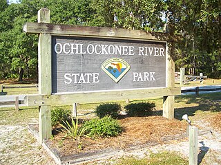
Ochlockonee River State Park is a Florida State Park located in Wakulla County, Florida, south of the town of Sopchoppy in the Florida Panhandle. Located off of U.S. 319 on the Ochlockonee River, just north of the Gulf of Mexico coast, it is surrounded by the Apalachicola National Forest and the St. Marks National Wildlife Refuge and provides important habitat for the endangered red-cockaded woodpecker.

St. George Island is an island and Census-designated place (CDP) off the Florida Panhandle in the northern Gulf of Mexico. It is in Franklin County, Florida, United States.

The Apalachicola National Forest is the largest U.S. National Forest in the state of Florida. It encompasses 632,890 acres and is the only national forest located in the Florida Panhandle. The National Forest provides water and land-based outdoors activities such as off-road biking, hiking, swimming, boating, hunting, fishing, horse-back riding, and off-road ATV usage.

The Cape St. George Light is a 72-foot (22 m) high brick lighthouse which had originally stood for 153 years on St. George Island, Florida, until toppling into the Gulf of Mexico October 22, 2005. The pieces of the lighthouse were retrieved, and in April 2008, the light's restoration was completed.
St. Vincent Island is the westernmost of four barrier islands in the northwestern Florida Gulf coast which include Cape St. George Island, St. George Island and Dog Island. The island is located just offshore in Franklin County, Florida south southeast of Cape San Blas and north of Cape St. George Island close to the mouth of the Apalachicola River and the town of Apalachicola on the Florida Panhandle.
St. Marks National Wildlife Refuge, in Wakulla County, Florida, is one of the oldest wildlife refuges in the United States. Established in 1931 as a wintering ground for migratory birds, it encompasses more than 83,000 acres spread between Wakulla, Jefferson, and Taylor Counties in the state of Florida.
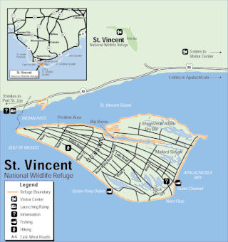
The St. Vincent National Wildlife Refuge is part of the United States National Wildlife Refuge System, located in the Gulf of Mexico off the coast of Apalachicola, on the barrier island of St. Vincent. The refuge includes Pig Island, located in the southwest corner of St. Joseph Bay, nearly 9 miles west of St. Vincent and 86 acres of mainland Florida along Franklin County Road 30A. The 12,490 acre (51 km2) refuge was established in 1968.
Great Florida Birding and Wildlife Trail (GFBWT) is a 2,000 mile (3200 km) long collection of more than 500 locations in the U.S. state of Florida where the state's bird habitats are protected. The trail promotes birdwatching, environmental education and ecotourism. The GFBWT is a program of the Florida Fish and Wildlife Conservation Commission, supported in part by the Florida Department of Transportation and the Wildlife Foundation of Florida. It is modeled after the successful Great Texas Coastal Birding Trail. Trail sites area identifiable by prominent road signs bearing the Swallow-tailed kite logo.

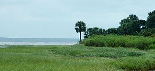
Alligator Point is an unincorporated community on St. James Island in Franklin County, Florida, United States. It is located along U.S. 98, south of Bald Point State Park, along the Gulf of Mexico. Alligator Point is a small beach community made up of mostly beach homes and the Alligator Point Yacht Basin. Located on Florida's "Forgotten Coast", nearby attractions include Bald Point State Park and the St. Marks Wildlife Refuge. Alligator Harbor is known for its clam harvesting and was featured on Discovery Channel's "Dirty Jobs."

The Big Bend of Florida, United States, is an informally named geographic region of North Florida where the Florida Panhandle transitions to the Florida Peninsula south and east of Tallahassee. The region is known for its vast woodlands and marshlands and its low population density relative to much of the state. The area is home to the largest single spring in the United States, the Alapaha Rise, and the longest surveyed underwater cave in the United States, the 32-mile (51 km) Wakulla-Leon Sinks cave system.
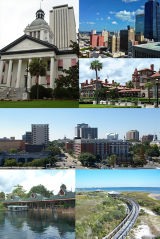
The following is an alphabetical list of articles related to the U.S. state of Florida.
North Florida, sometimes shortened to NorFlo, is a region of the U.S. state of Florida comprising the northernmost part of the state. Along with South Florida and Central Florida, it is one of Florida's three most common "directional" regions. It includes Jacksonville and nearby localities in Northeast Florida, an interior region known as North Central Florida, and the Florida Panhandle.
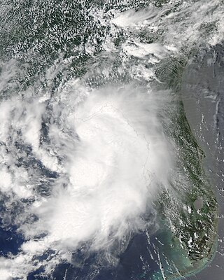
Tropical Storm Claudette was the third named storm of the 2009 Atlantic hurricane season and the first tropical cyclone of 2009 to affect the United States. Forming out of a tropical wave and an upper-level low pressure system on August 16, Claudette quickly intensified into a tropical storm offshore south of Tallahassee, Florida. By the afternoon, the storm had attained winds of 60 mph (97 km/h) and steadily tracked towards the Florida Panhandle. Early on August 17, the center of Claudette made landfall on Santa Rosa Island. Several hours after landfall, the storm weakened to a tropical depression and the Hydrometeorological Prediction Center took over primary responsibility of the storm. Later on August 17, the final public advisory was issued on the system as it dissipated over Alabama.

Tropical Storm Debby was a tropical cyclone that caused extensive flooding in North Florida and Central Florida during late June 2012. The fourth tropical cyclone and named storm of the 2012 Atlantic hurricane season, Debby developed from a trough of low pressure in the central Gulf of Mexico on June 23. At the time, Debby was the earliest fourth named storm to form within the Atlantic basin on record. Despite a projected track toward landfall in Louisiana or Texas, the storm headed the opposite direction, moving slowly north-northeast and northeastward. The storm slowly strengthened, and at 1800 UTC on June 25, attained its peak intensity with maximum sustained winds of 65 mph (100 km/h). Dry air, westerly wind shear, and upwelling of cold waters prevented further intensification over the next 24 hours. Instead, Debby weakened, and by late on June 26, it was a minimal tropical storm. At 2100 UTC, the storm made landfall near Steinhatchee, Florida with winds of 40 mph (65 km/h). Once inland, the system continued to weaken while crossing Florida, and dissipated shortly after emerging into the Atlantic on June 27.

Hurricane Michael was a powerful and destructive tropical cyclone that became the first Category 5 hurricane to make landfall in the contiguous United States since Andrew in 1992. It was the third-most intense Atlantic hurricane to make landfall in the contiguous United States in terms of pressure, behind the 1935 Labor Day hurricane and Hurricane Camille in 1969. Michael was the first Category 5 hurricane on record to impact the Florida Panhandle, the fourth-strongest landfalling hurricane in the contiguous United States, in terms of wind speed, and the most intense hurricane on record to strike the United States in the month of October.
| Topics |  Map of North Florida | |
|---|---|---|
| Counties | ||
| Major cities | ||
| Cities and towns 50k–100k | ||
| Cities and towns 10k–40k | ||
| Metro areas | ||
| Regions | ||