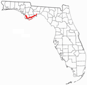
Franklin County is a county along the Gulf of Mexico in the panhandle of the U.S. state of Florida. As of the 2020 census, the population was 12,451, making it the third-least populous county in Florida. The county seat is Apalachicola.

Carrabelle is a city in Franklin County along Florida's Panhandle, United States. The population was 2,778 as of the 2010 census. Carrabelle is located east of Apalachicola at the mouth of the Carrabelle River on the Gulf of Mexico.

Biscayne Bay is a lagoon, with characteristics of an estuary, located on the Atlantic coast of South Florida, United States. The northern end of the lagoon is surrounded by the densely developed heart of the Miami metropolitan area, while the southern end is largely undeveloped, with a large portion of the lagoon included in Biscayne National Park. Sources differ on the extent of the lagoon. The part of the lagoon that is traditionally called "Biscayne Bay" is approximately 35 miles (56 km) long and up to 8 miles (13 km) wide, with a surface area of 221 square miles (570 km2). Various definitions may include Dumfoundling Bay, Card Sound, and Barnes Sound in a larger "Biscayne Bay", which is 60 miles (97 km) long, with a surface area of about 271 square miles (700 km2).

Key Biscayne is an island located in Miami-Dade County, Florida, United States, between the Atlantic Ocean and Biscayne Bay. It is the southernmost of the barrier islands along the Atlantic coast of Florida, and lies south of Miami Beach and southeast of Miami. The key is connected to Miami via the Rickenbacker Causeway, originally built in 1947.

The Florida Panhandle is the northwestern part of the U.S. state of Florida; it is a strip of land roughly 200 miles (320 km) long and 50 to 100 miles wide, lying between Alabama on the north and the west, Georgia on the north, and the Gulf of Mexico to the south. Its eastern boundary is arbitrarily defined. In terms of population, major communities include Tallahassee, Pensacola, and Panama City.
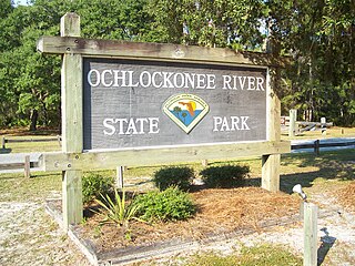
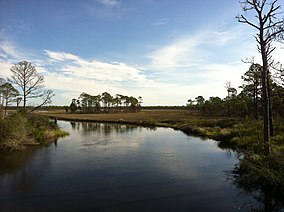
Ochlockonee River State Park is a Florida State Park located in Wakulla County, Florida, south of the town of Sopchoppy in the Florida Panhandle. Located off of U.S. 319 on the Ochlockonee River, just north of the Gulf of Mexico coast, it is surrounded by the Apalachicola National Forest and the St. Marks National Wildlife Refuge and provides important habitat for the endangered red-cockaded woodpecker.

St. George Island is an island and Census-designated place (CDP) off the Florida Panhandle in the northern Gulf of Mexico. It is in Franklin County, Florida, United States.
St. Joseph was a boomtown that briefly became the largest community in Florida, United States, before being abandoned less than eight years after it was founded. St. Joseph was founded in 1835 on the shores of St. Joseph Bay. A brief period of prosperity was ended by a yellow fever epidemic in 1841, and the abandoned remnants of the town were destroyed by a storm surge in 1844. The town site is in Gulf County, Florida, near the city of Port St. Joe.

Tate's Hell State Forest is 202,000 acres (819 km²) of land in Franklin and Liberty counties in Florida. The forest is located near Carrabelle off US 98 along the Gulf coast and on St. James Island. At one time, Tate's Hell supported at least 12 major habitats including: wet flatwoods, wet prairie, seepage slope, baygall, floodplain forest, floodplain swamp, basin swamp, upland hardwood forest, sandhill, pine ridges, dense titi swamp thickets and scrub. Tate's Hell State Forest is an important hydrologic area and includes a section of the New River. The park's watershed provides fresh water into the Apalachicola Bay, the Carrabelle River and the Ochlockonee River.
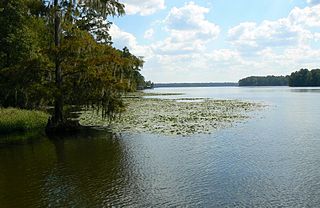
Lake Talquin is a reservoir located on the Ochlockonee River between Leon County and Gadsden County in north Florida. The lake, located about 10 miles (15 km) west of Tallahassee, is south of Interstate 10 and bordered by State Road 20 on the east and State Road 267 on the west.
The Forgotten Coast refers to a largely untouched and uninhabited area of coastline in the panhandle of the US state of Florida. The term, also a trademark, was first used in 1992, but the Forgotten Coast's exact location is not agreed upon.
The Ochlockonee River is a fast running river, except where it has been dammed to form Lake Talquin in Florida, originating in Georgia and flowing for 206 miles (332 km) before terminating in Florida.

Tropical Storm Edouard was the first of eight named storms to form in September 2002, the most such storms in the North Atlantic for any month at the time. The fifth tropical storm of the 2002 Atlantic hurricane season, Edouard developed into a tropical cyclone on September 1 from an area of atmospheric convection associated with a cold front east of Florida. Under weak steering currents, Edouard drifted to the north and executed a clockwise loop to the west. Despite moderate to strong levels of wind shear, the storm reached a peak intensity of 65 mph (100 km/h) on September 3, but quickly weakened as it tracked westward. Edouard made landfall on northeastern Florida on September 5, and after crossing the state it dissipated on September 6 while becoming absorbed into the larger circulation of Tropical Storm Fay.

The Tiger Bay State Forest is in the U.S. state of Florida. The 27,330-acre (11,060 ha) forest is located in Volusia County, Florida, between Daytona Beach and DeLand.
Erie MetroParks was formed as the "Erie County Metropolitan Park District" in 1968 and adopted its current name in 1991. It consists of 13 individual park areas located throughout Erie County in the US state of Ohio covering approximately 3,254 acres (1,317 ha).
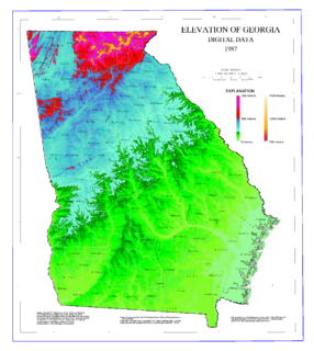
The geography of Georgia describes a state in the Southeastern United States in North America. The Golden Isles of Georgia lie off the coast of the state. The main geographical features include mountains such as the Ridge-and-valley Appalachians in the northwest, the Blue Ridge Mountains in the northeast, the Piedmont plateau in the central portion of the state and Coastal Plain in the south. The highest area in Georgia is Brasstown Bald which is 1,458 m (4,783 ft) above sea level, while the lowest is at sea level, at the Atlantic Ocean. Georgia is located at approximately 33° N 83.5° W. The state has a total area of 154,077 km2 (59,489 sq mi) and the geographic center is located in Twiggs County.
The Little River is a minor river in the Florida Big Bend. A tributary of the Ochlockonee River, it is approximately 14 miles (23 km) in length and is located entirely within Gadsden County.

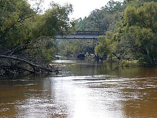
Crooked River is a waterway in Franklin County, Florida, that connects the tidal estuary of the Ochlockonee River to a junction with the tidal Carrabelle River and the New River above the town of Carrabelle, Florida. The Crooked River channel is 41 kilometres (25 mi) long, while its ends are 24 kilometres (15 mi) apart.
St. James Island is an inhabited area along the Florida Panhandle surrounded by the Carrabelle River, Crooked River, Ochlockonee River, and St. George Sound in Franklin County, Florida. It is more than 20 miles (32 km) long and averages 4 miles (6.4 km) wide. It is separated from the mainland by the tidal Crooked River. The highest elevation on St. James Island is 70 feet (21 m) above sea level, the highest on the Gulf coast of Florida between Pensacola and Tampa.
Galop Island is an uninhabited island in the Saint Lawrence River located in St. Lawrence County, northeast of Ogdensburg, New York. The 675-acre (2.73 km2) island is owned by the New York Power Authority and managed by the New York State Office of Parks, Recreation and Historic Preservation as the undeveloped Galop Island State Park.