
A subterranean river is a river that runs wholly or partly beneath the ground surface – one where the riverbed does not represent the surface of the Earth. It is distinct from an aquifer, which may flow like a river but is contained within a permeable layer of rock or other unconsolidated materials. A river flowing below ground level in an open gorge is not classed as subterranean.

Natural Bridge Battlefield State Historic Site is a Florida State Park in Leon County, Florida. It is located roughly between the city of Tallahassee and the town of St. Marks. During the American Civil War, the Battle of Natural Bridge was fought here on March 6, 1865. The site is named for a natural bridge over the St. Marks River. The Civil War Trust, a division of the American Battlefield Trust, and its partners have acquired and preserved 110 acres of the battlefield park.
Tarkiln Bayou Preserve State Park is a 4,290-acre (17.4 km2) preserve, a unit of Florida State Park located 10 miles (16 km) southwest of Pensacola, in northwestern Florida. It is home to four species of endangered pitcher plants, as well as other rare and endangered plant species. The rare, carnivorous white–top pitcher plant is unique to the Gulf Coast and found only between the Apalachicola and Mississippi rivers. Almost 100 other rare plants and animals depend on the wet prairie habitat, including the alligator snapping turtle, sweet pitcher plant, and Chapman's butterwort. Tarkiln Bayou Preserve State Park is located in Escambia County about 1.5 miles (2.4 km) south of the intersection of U.S. Hwy. 98 and State Road 293.
Yellow River Marsh Preserve State Park is a Florida State Park located on Garcon Point, south of Milton, in northwestern Florida. A small parking area, gazebo, and public access point are located on Dickerson City Road. Located on County Road 191, approximately one mile north of the intersection with County Road 281 and along both sides of the highway on Blackwater Bay.

Crystal River Preserve State Park is a Florida State Park, originally known as the Crystal River Buffer Preserve. The Preserve comprises 27,500 acres of salt marsh, tidal creeks, mangrove islands, hardwood forests, coastal scrub and pine flat woods.

The Little Manatee River flows 51 miles (82 km), from east of Fort Lonesome, Florida South of Hwy 674 and Earl Reynolds Rd In Hillsborough County through southern Hillsborough County, Florida including towns such as Sun City, Florida, and Gulf City, Florida and northern Manatee County, Florida into Tampa Bay. It has a drainage basin of 222 square miles (570 km2). It flows along the Little Manatee River State Park for part of its route. Portions of the river Such as Hayes Bayou and Mills Bayou have been designated as an Outstanding Florida Water and are part of the Cockroach Bay Aquatic Preserve.
O'Leno State Park is a Florida State Park located on the Santa Fe River six miles north of High Springs on U.S. 441. Many facilities at the park were built by the Civilian Conservation Corps in the 1930s.
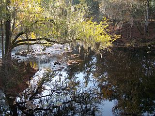
The St. Marks River is a river in the Big Bend region of Florida. It has been classified by the Florida Department of Environmental Protection as an Outstanding Florida Water, and is the easternmost river within the Northwest Florida Water Management District.
Waccasassa Bay Preserve State Park is a 30,784-acre (124.58 km2) salt marsh that stretches from Cedar Key and Yankee Town, and is only accessible by boat. It includes the part of Gulf Hammock wetlands area that is closest to the Gulf.
Pumpkin Hill Creek Preserve State Park is a Florida State Park, located 12 miles north of Jacksonville, west of Big and Little Talbot Islands.
St. Sebastian River Preserve State Park is a Florida State Park, located three miles north of Fellsmere.

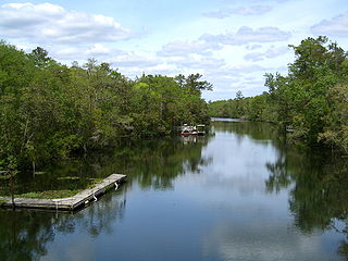
The Santa Fe River is a 75-mile (121 km) river in northern Florida. The watershed of the river is approximately 1,380 square miles (3,574 km2) and spreads across southern Columbia, southern Suwannee, western Bradford, far southern Baker, Union, northern and eastern Gilchrist, and northern Alachua counties. The headwaters of the river are Lake Santa Fe, near Keystone Heights. The Santa Fe River is usually a slow-flowing river. This slow speed, combined with the abundant leaf-drop from nearby trees, especially Bald Cypress, leads to a very dark-brown river due to dissolved tannins.

The Myakka River is a river in southwestern Florida. It arises near the Hardee-Manatee county line and flows southwest and then southeast through Manatee, Sarasota and Charlotte counties to Charlotte Harbor, an arm of the Gulf of Mexico. The river is 72 miles (116 km) long and has a drainage basin of 314.7 square miles (815 km2). The last 20 miles (32 km) of the river is tidal and brackish.

The Tomoka River is a north-flowing river in Volusia County, Florida, United States. It drains an area of about 110 square miles (280 km2) and has a length of 19.6 miles (31.5 km).

The Loxahatchee River is a 7.6 mile river near the southeast coast of Florida. It is a National Wild and Scenic River, one of only two in the state, and received its federal designation on May 17, 1985. The source of the Loxahatchee River is in Riverbend Park on the south side of Indiantown Road about 1.5 miles west of I-95 and Florida's Turnpike in Jupiter, Florida. The Loxahatchee River flows out of the Jupiter Inlet and into the Atlantic Ocean. This river was the inspiration for Florida film producer Elam Stoltzfus' 2005 project "Our Signature: the Wild and Scenic Loxahatchee River," a film done in conjunction with the Loxahatchee River Preservation Initiative.

The Seminole State Forest is in the U.S. state of Florida. The 25,812-acre (10,446 ha) forest is located in Central Florida, near Eustis. Access to the forest is available from Florida State Road 44, Lake County Road 46A and Florida State Road 46. Surrounding parks and preserved areas include Lower Wekiva River Preserve State Park, Rock Springs Run State Reserve, Lake Norris Conservation Area, and the Ocala National Forest. The Florida National Scenic Trail runs through the from southeast to northwest.

North Florida is a region of the U.S. state of Florida comprising the northernmost part of the state. Along with South Florida and Central Florida, it is one of Florida's three most common "directional" regions. It includes Jacksonville and nearby localities in Northeast Florida, an interior region known as North Central Florida, and the Florida Panhandle.

The Nature Coast State Trail (NCST) is a 31.7-mile long segment of Florida's Statewide System of Greenways and Trails System built along abandoned railroad tracks, and designated by the U.S. Department of the Interior as a National Recreation Trail. It has two primary sections following unused rail lines that were originally built by the Atlantic Coast Line Railroad. It includes historic sites such as an old train trestle bridge over the Suwannee River near Old Town and train stations in Trenton, Cross City, and Chiefland. At Wilcox Junction abandoned rail tracks cross and connect with several communities. The trail is available to hikers, cyclists, and horse riders.

