Hurricane Charley was the first of four separate hurricanes to impact or strike Florida during 2004,along with Frances,Ivan and Jeanne,as well as one of the strongest hurricanes ever to strike the United States. It was the third named storm,the second hurricane,and the second major hurricane of the 2004 Atlantic hurricane season. Charley lasted from August 9 to 15,and at its peak intensity it attained 150mph (240km/h) winds,making it a strong Category4 hurricane on the Saffir–Simpson scale. It made landfall in Southwest Florida at maximum strength,making it the strongest hurricane to hit the United States since Hurricane Andrew struck Florida in 1992 and tied with Hurricane Ian as the strongest hurricane to hit southwest Florida in recorded history.
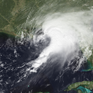
After moving slowly through the Caribbean,Charley crossed Cuba on Friday,August 13 as a Category 3 hurricane,causing heavy damage and four deaths. That same day,it crossed over the Dry Tortugas,just 22hours after Tropical Storm Bonnie had struck northwestern Florida. It was the first time in history that two tropical cyclones struck the same state in a 24-hour period.[1] At its peak intensity of 150mph (240km/h),Hurricane Charley struck the northern tip of Captiva Island and the southern tip of North Captiva Island,before crossing over Bokeelia causing severe damage.[2] Charley then continued to produce severe damage as it made landfall on the peninsula in Punta Gorda. It continued to the north-northeast along the Peace River corridor,devastating Punta Gorda,Port Charlotte,Cleveland,Fort Ogden,Nocatee,Arcadia,Zolfo Springs,Sebring,Lake Placid,and Wauchula. Zolfo Springs was isolated for nearly two days as masses of large trees,power poles,power lines,transformers,and debris filled the streets. Wauchula sustained gusts to 147mph (237km/h);buildings in the downtown areas caved onto Main Street.
Ultimately,the storm passed through the central and eastern parts of the Orlando metropolitan area,still carrying winds gusting up to 106mph (171km/h). The city of Winter Park,north of Orlando,also sustained considerable damage since its many old,large oak trees had not experienced high winds. Falling trees tore down power utilities and smashed cars,and their huge roots lifted underground water and sewer utilities. The storm slowed as it exited the state over Ormond Beach just north of Daytona Beach. The storm was ultimately absorbed by a front in the Atlantic Ocean shortly after sunrise on August 15,near southeastern Massachusetts.[3][4]
Charley was initially expected to hit further north in Tampa,and caught many Floridians off-guard due to a sudden change in the storm's track as it approached the state. Along its path,Charley caused 10deaths and $16.9billion in damage to insured residential property,making it the second costliest hurricane in United States history at the time.[5] Charley was a compact,fast-moving storm,which limited the scope and severity of the damage.
Meteorological history
Map plotting the storm's track and intensity,according to the Saffir–Simpson scale
Charley began as a tropical wave that moved off the west coast of Africa on August 4.[3] It moved quickly westward and steadily organized over the open Atlantic Ocean, with convection developing in curved bands.[3] The wave continued to develop as it approached the Lesser Antilles, and became Tropical Depression Three on August 9 while 115mi (185km) south-southeast of Barbados, near the island of Grenada, however, the threat to Barbados was short-lived.[3][6] Low upper-level wind shear and well-defined outflow contributed to further intensification, and the depression strengthened on August 10, despite being located in the eastern Caribbean, which is an area not particularly suited to tropical cyclogenesis.[4] At this time, the National Hurricane Center in Miami designated the name "Charley".[3]
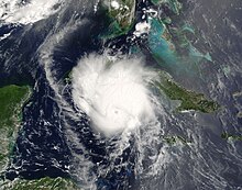
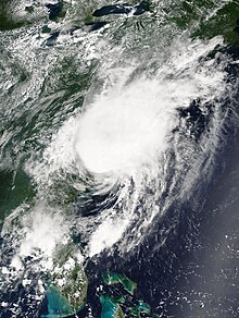
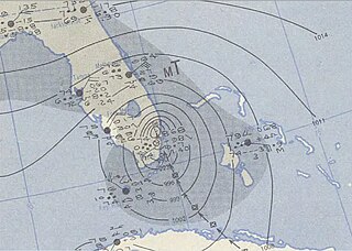
Hurricane Charley approaching Cuba on August 12
A strong ridge of high pressure to the system's north forced Charley to change track quickly to the west-northwest. It continued to strengthen and became a Category 1 hurricane on August 11, while 90mi (140km) south of Kingston, Jamaica.[3][6] The storm was being steered around the periphery of the high pressure area, and as a result, Charley changed direction toward the northwest. The following day, the core passed 40mi (64km) southwest of Jamaica, affecting the island on August 11 and 12.[4][6] The storm then passed 15mi (24km) northeast of Grand Cayman, reaching Category2 status just after passing the island.[3][4] The hurricane continued to strengthen as it turned to the northwest and rounded the southwest portion of the subtropical ridge, becoming a major hurricane—a storm classified as a Category 3 hurricane or higher—just before making landfall on southern Cuba.[3] Charley came ashore near Punta Cayamas with maximum sustained winds of 120mph (190km/h) and gusts of up to 133mph (214km/h), at about 0430 UTC on August 13.[6] It crossed the island, passing about 15mi (24km) west of downtown Havana before weakening to 110mph (180km/h).[3]
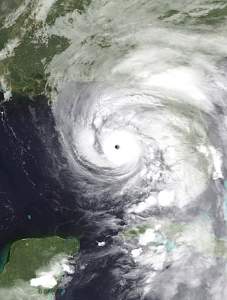
Charley rapidly intensifying as it approached Florida on August 13
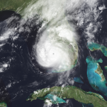
After crossing Cuba near Menelao Mora, Hurricane Charley accelerated to the north-northeast, toward the southwest coast of Florida in response to the approach of an unseasonal mid-tropospheric trough.[6] Charley passed over the Dry Tortugas at 1200 UTC on August 13, with maximum winds of about 110mph (175km/h).[3][4] The strike occurred only 22hours after Tropical Storm Bonnie made landfall on St. Vincent Island, marking the first time two tropical cyclones hit the same state within a 24-hour period.[1]Then Charley rapidly intensified, strengthening from a 110mph (175km/h) hurricane with a minimum central barometric pressure of 965mbar (965hPa; 28.5inHg) to a 145mph (235km/h) hurricane with a pressure of 947mbar (947hPa; 28.0inHg) in just threehours. It continued to strengthen as it turned more to the northeast, and made landfall near the island of Cayo Costa, Florida as a 150mph (240km/h)Category 4 hurricane with a pressure of 941mbar (941hPa; 27.8inHg) at approximately 1945 UTC on August 13.[4][7] An hour later, the hurricane struck Punta Gorda as a 145mph (235km/h) storm and then passed up through Port Charlotte and the Charlotte Harbor.[3] However, the eye had shrunk before landfall, limiting the most powerful winds to an area within 7mi (11km) of the center.[3]
Charley weakened considerably due to its passage over land, but still retained sustained winds of about 85mph (135km/h) as it passed directly over Orlando between 0020 and 0140 UTC August 14; gusts of up to 106mph (171km/h) were recorded at Orlando International Airport.[4] It cut a swath of destruction across Florida, also passing near Kissimmee.[3] The hurricane reemerged into the Atlantic Ocean after crossing directly over New Smyrna Beach as a Category1 hurricane, but restrengthened slightly over open waters.[3][4] Continuing to move rapidly to the north-northeast, Charley struck near Cape Romain National Wildlife Refuge, South Carolina as an 80mph (130km/h) hurricane, moved offshore briefly, and made its final landfall near North Myrtle Beach as a minimal hurricane, with winds of 75mph (120km/h).[4] Charley then began interacting with an approaching frontal boundary, becoming a tropical storm over southeastern North Carolina.[4] After moving back into the Atlantic Ocean near Virginia Beach on August 15, the storm became extratropical and became embedded in the frontal zone.[3][4] The extratropical storm continued to move rapidly to the northeast, and was completely absorbed by the front shortly after sunrise on August 15, near southeastern Massachusetts.[3][4]
On August 10, two days before the hurricane passed near the island, Jamaican officials issued a tropical storm warning, which was upgraded to a hurricane warning a day later.[3] In Jamaica, the threat of the storm forced the country's two airports to close, and also forced two cruise ships to reroute.[8] The Cayman Islands issued a hurricane warning on August 11, a day before the hurricane passed near the archipelago.[3]
Cuban government officials issued a hurricane watch for the southern coastline on August 11, two days before the hurricane struck the island. This was upgraded to a hurricane warning on the 12th, 13 ½ hours before Charley made landfall.[3] Because of the threat, the government issued a mandatory evacuation for 235,000citizens and 159,000animals in the area of the expected impact.[9] An additional 3,800residents were evacuated from offshore islands, while 47,000 in Havana were transported from old, unsafe buildings to safer areas.[10] The people were transported to shelters provisioned with supplies. In addition, the power grid in southern Cuba was turned off to avoid accidents.[9]
On August 11, Florida governorJeb Bush issued a state of emergency declaration due to the impending threat Charley presented to the state while the storm was still located south of Jamaica.[11] The National Hurricane Center issued hurricane warnings for the Florida Keys and from Cape Sable to the mouth of the Suwannee River a day prior to Charley's passage through the state, while tropical storm warnings were issued elsewhere throughout Florida.[3] Because of the threat, 1.9million people along the Florida west coast were urged to evacuate, including 380,000residents in the Tampa Bay area, and 11,000 in the Florida Keys.[12][13][14] It was the largest evacuation order for Pinellas County history,[14] and the largest evacuation request in Florida since Hurricane Floyd five years before. Many Floridians remained despite the evacuation order, as authorities estimated that up to a million people would not go to shelters;[15] instead, these residents boarded up their homes and bought supplies to ride out the storm.[13] However, about 1.42million people evacuated their homes in Florida, and approximately 50,000residents were placed in shelters throughout the state.[16][17] Power companies mobilized workers to prepare for the expected widespread power outages. MacDill Air Force Base, home of U.S. Central Command (USCENTCOM) and the U.S. military center for the Iraq War, severely limited its staff on base, shifting most of its operations to its forward headquarters in Doha, Qatar.[13] Similarly, Kennedy Space Center, which usually counts with 13,000on-site personnel, reduced its staff to only 200people in preparation for the hurricane, and secured all Space Shuttles by sealing them in their hangars. Many amusement parks in the Orlando area closed early, and Walt Disney World's Animal Kingdom remained closed. This was only the second time in history that a Disney park was closed due to a hurricane, with the other occurrence being after Hurricane Floyd.[18] The approaching hurricane also forced several cruise ships to reroute their paths,[13] and forced rail service between Miami and New York to shut down.[19]
The rapid strengthening of Charley in the eastern Gulf of Mexico caught many by surprise. Around five hours before its Florida landfall, Charley was a strong Category2 hurricane predicted to strengthen its strongest winds to 115mph (185km/h) upon its landfall in the Tampa–Saint Petersburg area.[20] About two hours before landfall, the National Hurricane Center issued a special advisory, notifying the public that Charley had become a 145mph (235km/h) Category4 hurricane, with a predicted landfall location in the Port Charlotte area.[21] As a result of this change in forecast, numerous people in the Charlotte County area were unprepared for the hurricane, although the new track prediction was well within the previous forecast's margin of error. National Hurricane Center forecasting intern Robbie Berg publicly blamed the media for misleading residents into believing that a Tampa landfall was inevitable. He also stated that residents of Port Charlotte had ample warning,[22] as a hurricane warning had been issued for the landfall area 23hours before, and a hurricane watch had existed for 35hours.[3]
Several local meteorologists, however, did depart from the official predictions of a Tampa Bay landfall as early as the morning of August 13. Jim Farrell[23] of WINK, Robert Van Winkle WBBH, Steve Jerve of WFLA in Tampa, Jim Reif of WZVN in Fort Myers, and Tom Terry of WFTV in Orlando all broke with their national news forecasts and stated at around 1500 UTC that Charley was going to turn early, striking around Charlotte Harbor and traveling over Orlando, as would prove to be the case.[24]
Following the Florida landfall, Georgia GovernorSonny Perdue declared a state of emergency as a precaution against a 4–7ft (1.2–2.1m) storm surge and price gouging.[25] In South Carolina, GovernorMark Sanford declared a state of emergency as Charley approached its final landfall. Two coastal counties were forced to evacuate, with state troopers redirecting traffic further inland from Myrtle Beach.[18] In all, 180,000 evacuated from the Grand Strand area.[26]
One death in Jamaica, four deaths in Cuba, and ten deaths in the United States were directly attributed to Charley.[3] Numerous injuries were reported, as well as 25 indirect deaths in the U.S.[3]
Property damage from Charley in the United States was estimated by the NHC to be $16billion.[27] At the time, this figure made Charley the second costliest hurricane in United States history, behind 1992's Hurricane Andrew's $27.3billion.[citation needed]
In Jamaica, strong winds caused moderate damage to the agricultural sector, with crop and livestock damage totaling to $1.44million.[28] As the storm traveled along the southwest coast of Jamaica, it caused heavy wind and rain damage.[6] Damage was heaviest in Saint Elizabeth Parish, where 100people had to be housed in six shelters. Strong winds downed trees and power lines, causing power outages and blocking roads.[29] Throughout the country, Charley caused $4.1million in damage and one fatality.[6] In spite of the close approach that Charley made on the Cayman Islands, the islands were mostly spared, and were subjected to little damage.[29] Rainfall was light, peaking at 0.9 inches (23mm) in Grand Cayman, while Cayman Brac reported tropical storm force winds.[3]
Operationally, forecasters estimated that Charley struck southern Cuba as a 105mph (170km/h) Category2 hurricane on the Saffir–Simpson scale.[30] In post-hurricane-season analysis, Charley was determined to have struck southern Cuba as a 120mph (195km/h) hurricane; the original estimate was revised based on a report of a 118mph (190km/h) sustained wind measurement in Playa Baracoa, and meant that Charley was a major hurricane at landfall.[6] The hurricane produced a storm surge of up to 13.1ft (4.0m) in Playa Cajio;[3] on the other hand, Charley's quick passage caused precipitation amounts to be small, with the largest total, 5.87 inches (149mm) occurring in Mariel.[6]
Strong wind gusts downed nearly 1,500power lines and knocked over 28 large high tension wire towers at a power plant in Mariel. As a result, more than half of the electricity customers in Havana Province were left without power for 12days after the storm, and all of Pinar del Río Province was without power for over 11days. Blackouts continued in areas where power returned. The power outages resulted in lack of drinking water for numerous people, including no potable water in the city of Havana for four days. As a result, the Cuban government sent water tanks to satisfy the short term need. Similarly, there was a lack of gas for cooking for over a week. However, one Cuban government official stated that it could take up to two months for basic utilities to be returned to many isolated villages.[10]
Near its landfall location, Charley destroyed 290 of the 300houses in the village, while over 70,000homes in Havana were either damaged or destroyed. Numerous hotels reported damage, potentially impacting the important tourism industry in the country. Agricultural damage was heavy, with the hurricane damaging more than 3,000 agricultural institutions. Citrus officials estimated a loss of 15,000metric tons of grapefruit on the Isle of Youth, while strong winds ruined 66,000metric tons of citrus trees in the Havana area. Charley also destroyed around 57,000acres (230km2) of fruit trees in the Havana area.[10] Approximately 95% of the sugar cane, bean, and banana crops were affected in Cuban territory.[31] In all, Charley was directly responsible for four deaths in Cuba, and was responsible for $923million in property damage, primarily from agricultural losses.[6]
Hurricane Charley severely affected the state of Florida. There were nine direct fatalities, 20indirect fatalities, and numerous injuries attributed to the storm.[3] Property damage was estimated at $5.4billion, and approximately $285million in agricultural damage.[17] However, due to Charley's speed (it crossed the Florida peninsula in approximately seven hours) and small size, rainfall along the eyewall was mostly limited to 4–6 inches (10–15 centimetres).[17]
While moving northward to the west of the Florida Keys, Charley produced moderate winds of 48mph (77km/h) with gusts to 60mph (95km/h) in Key West.[3] The winds toppled a few trees, power lines, and unreinforced signs. A boat, knocked loose by strong waves, struck a power transmission line, causing widespread power outages from Marathon to Key West. On Fort Jefferson in the Dry Tortugas, the hurricane produced an estimated storm surge of up to 6ft (1.8m). The surge, combined with incoming waves, caused extensive flooding in the park and damaged numerous docks. In spite of this, property damage was minimal in the area, totaling $160,000.[12]
Hurricane Charley passed directly over Captiva Island near Cayo Costa with peak winds of 150mph (240km/h).[3] The Category4hurricane produced an estimated storm surge of up to 6.5ft (2.0m) on the island, which is lower than expected for a storm of its intensity. The decrease in the height of the surge was due to the hurricane's small size and its rapid intensification just prior to landfall. Furthermore, the storm surge, combined with the strong pressure gradient, produced a 450-meter-wide (0.28mi) inlet on North Captiva Island,[33] known as Charley's Cut. Strong waves and storm surge caused severe beach erosion and dune damage at various locations. The storm severely damaged five houses, lightly damaged many others, and downed many trees on Gasparilla Island. At least half of the 300homes on North Captiva Island were substantially damaged, including ten that were destroyed. On Captiva Island, the strong winds severely damaged most houses, as well as several recreational buildings.[34]
The city of Arcadia in DeSoto County saw extreme damage, in spite of being relatively further inland.[35] About 95% of the buildings in the downtown area saw some sort of damage. The only shelter in the town had its roof torn open by the wind, leaving 3,500 evacuees inside unprotected from the onslaught of the storm.[36]
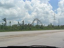
Damage caused to a gas station by Hurricane Charley in Kissimmee, Florida.
Hardee County saw property damage estimated at $750million, along with six injuries, but no deaths were reported. Charley caused blackouts in the entire county, as well as damage to3,600homes and the destruction of1,400. A radio tower near Sebring was toppled, along with numerous trees and power poles along the north and east side of Highlands County. Additionally, there were several reports of severely damaged homes in Polk County near Babson Park and Avon Park. In Lake Wales, Florida, a sand mine lake encroached into State Road 60 due to wave action and swallowed a car. Additionally, Lake Wales saw 23,000buildings damaged, as well as the destruction of 739structures. Seven deaths were reported in the county, one of them determined to be direct.[37]
Throughout the rest of the islands in Sarasota, Charlotte, Lee, and Collier counties, strong winds from Hurricane Charley caused severe damage to hundreds of buildings and trees.[34] Lee County also endured an 8-foot (2.4m)storm surge.[17] These counties were exposed to Charley's eyewall, so they saw the most damage. Due to its small size, the area of most intense damage was located within a 10-mi (16-km) band centered on Charley's track, with additional heavy damage forming an outer band extending 7.5mi (12.1km) to each side of the inner swath of damage.[38] In Charlotte County, 80% of buildings were damaged.[39]
On mainland Florida, Charley produced a peak storm surge of 10–13 feet (3.0–4.0 metres) at Vanderbilt Beach near Naples, along with a much lower surge at its Punta Gorda landfall.[33] The hurricane dropped generally light rainfall across Florida, with the maximum amount of 9.88 inches (251mm) occurring in Bud Slough in Manatee County, east of Myakka River State Park.[4] In Punta Gorda's airport, where the hurricane made landfall, wind speeds of up to 90mph (140km/h) were measured, alongside gusts of up to 111mph (179km/h), before the instrument was blown apart, along with most of the planes and the airport itself.[3][38] The Charlotte Regional Medical Center recorded an unofficial peak wind gust of 172mph (277km/h).[3]Port Charlotte's Saint Joseph's Hospital had its roof blown away by Charley's strong winds.[38] Due to the compact nature of the hurricane, the storm's radius of maximum sustained winds only extended a short distance from its center. In comparison, Fort Myers, which is only 25mi (40km) from where Charley made landfall, experienced sustained winds of only 61mph (98km/h) with gusts of 78mph (126km/h).[3] In South Florida, Charley spawned several tornadoes, including a long-lived F2 that struck Clewiston,[40] and five weak tornadoes near the point where the hurricane made landfall.[41]
The most severe damage from Hurricane Charley occurred in Charlotte County. In Boca Grande, numerous houses sustained extensive roof damage, while thousands of trees and power lines were uprooted or snapped. In Port Charlotte and Punta Gorda, many buildings, RVs, and mobile homes were completely destroyed, while other buildings suffered roofing damage due to the powerful winds.[41]
Charley devastated Southwest Florida, causing $14.6billion in property damage on the peninsula of Florida alone. Many towns such as Punta Gorda and Port Charlotte were leveled by the hurricane. Trees were downed and trailer parks were obliterated as far as Ormond Beach.[42]
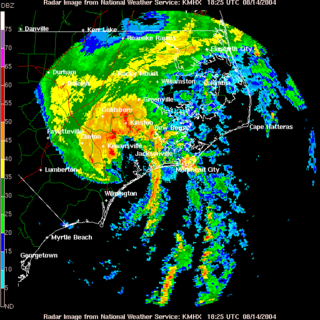
Charley also caused considerable damage in the central and eastern parts of the state. Several possible tornadoes occurred, with severe thunderstorms during the duration of the storm. Winds were estimated to be at 80mph (130km/h) sustained near, and to the north of Okeechobee, while winds at Orlando International Airport topped out around 110mph (175km/h) in a gust.[43] At Orlando International Airport, debris littered two runways and lashing winds tore the roofs off three terminals and shattered two giant glass panels in the main terminal.[44] The winds also ripped the roof right off of Brookside Elementary in Winter Park, leaving damage to the school, as well as the school's cafeteria.[45] The storm caused 2million customers to lose electricity in Florida.[38] In some areas, power was not restored for weeks: 136,000 residents had no electricity a week after Charley's landfall,[46] and 22,000customers, primarily from cooperatives, were still waiting for their service to be restored on August 26.[47] Citizens in Daytona Beach, New Smyrna Beach, and Port Orange in Southeastern Volusia County also dealt with storm surge from the St. Johns River and Halifax River, and Intracoastal Waterway as Charley passed over before re-emerging into the Atlantic Ocean. Further inland, Seminole County experienced some of the highest winds ever recorded from a hurricane in the area, with a gust of 97mph (156km/h) in Longwood at 0407 UTC on August 14 and 101mph (163km/h) in Altamonte Springs. Power was out in these areas for up to 12 days after the storm in some locations.[citation needed]
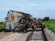
Empty railroad hopper cars toppled over as a result of high winds from Hurricane Charley in Fort Meade
Public schools in some counties in the path of the hurricane were scheduled to be closed for two weeks.[48] In some areas this was necessary because the school buildings were damaged or destroyed: all 59of Osceola County's schools were damaged, and one-third of Charlotte County's were destroyed by Charley's impact. DeSoto County schools saw $6million in damage, while Orange County Public Schools saw $9million in damage to their educational infrastructure.[49]
Agricultural losses were heavy. In Florida, the second-largest producer of oranges in the world, damage to the citrus crop was estimated at $200million, and caused a 50% increase in the price of grapefruit juice. Charley, along with the other storms that hit Florida during 2004, caused a total agricultural loss of $2.2billion. Other crops, nurseries, buildings, and agricultural equipment also suffered.[50]
Due to its track being directly over Interstate 4, Charley is sometimes referred to as the I-4 hurricane.[51]
Upon making landfall on northeastern South Carolina, Charley produced a storm tide that was unofficially measured to up to 7.19ft (2.19m) in Myrtle Beach. Wind gusts were moderate, peaking at 60mph (97km/h) in North Myrtle Beach, though there were several unofficial records of hurricane-force gusts.[3] Charley produced moderate rainfall along its path, peaking at over 7in (178mm).[4] Moderate winds knocked down numerous trees.[52] Flash flooding occurred in Charleston County, causing drainage problems.[53] Damage in South Carolina totaled to $20million.[3]
In North Carolina, Charley produced an estimated storm surge of 2–3ft (0.61–0.91m), along with waves of up to 8ft (2.4m) in height. This produced minor beach erosion along the coastline. Winds gusted from 60 to 70mph (97 to 113km/h), causing minor wind damage. Rainfall amounts in the state were moderate, ranging from 4 to 6in (100 to 150mm), but still caused flooding across seven North Carolina counties. The hurricane spawned five weak tornadoes across the state,[54] including an F1 tornado in Nags Head that damaged twenty structures.[55] Charley destroyed 40houses and damaged 2,231, 231 severely, including 221 damaged beach homes in Sunset Beach. Damage was the greatest in Brunswick County, where wind gusts peaked at 85mph (137km/h). Crop damage was also heavy in Brunswick County, with 50% of the tobacco crop lost and 30% of the corn and vegetable fields destroyed. Strong winds downed trees and power lines, leaving 65,000 without power.[56] Damage in North Carolina totaled to $25million.[3]
Tropical Storm Charley produced wind gusts of up to 72mph (116km/h) at Chesapeake Light in Virginia, causing scattered power outages. Rainfall was light, ranging from 2 to 3.7in (51 to 94mm).[57] Charley produced one tornado in Chesapeake and one in Virginia Beach. In Rhode Island, one man drowned in a rip current.[3]
Aftermath
Congressman Mark Foley checks out the travel trailers that FEMA provided as temporary housing in Port Charlotte
United States
President George W. Bush declared Florida a federal disaster area. He later reflected on the government response to Charley:
...the job of the federal government and the state government is to surge resources as quickly as possible to disaster areas. And that's exactly what's happening now. We choppered over and saw the devastation of this area. A lot of people's lives are turned upside down. We've got ice and water moving in, trailers for people...are moving in. The state is providing security...There's a lot of compassion moving in the area, the Red Cross is here.[58]
U.S. Health and Human Services Secretary Tommy Thompson released $11million in additional aid and other assistance to Florida, with $10million to be earmarked to Head Start facilities that need repair or new supplies, another $1million was provided to the DeSoto Memorial Hospital in Arcadia and Osceola Regional Medical Center in Kissimmee, and $200,000 would be spent to provide services to senior citizens. Across Florida, 114 food service operations and eight comfort stations were set up. FEMA opened four disaster recovery centers.[59]
Cuba
In Cuba, Hurricane Charley had disconnected the entirety Pinar del Río province from the Sistema Eléctrico Nacional (SEN).[60]:4 This damage to Cuba's electricity infrastructure became part of the impetus for Cuba's Energy Revolution campaign, which decentralized the country's electricity infrastructure, promoted renewable energy sources, and drastically decarbonized its economy.[60]:4–18
Because of the hurricane's effects in the United States, the name Charley was retired from the rotating lists of tropical cyclone names in the spring of 2005 by the World Meteorological Organization, and will never again be used for an Atlantic basin tropical cyclone.[61] The name was replaced with Colin for the 2010 season.[62]
Hurricane Donna (1960) – Another Category 4hurricane that crossed Florida from southwest to northeast
Hurricane Irma (2017) – A hurricane that made landfall as a Category 3hurricane on the southwest side of Florida
Hurricane Ian (2022) – A hurricane that also made landfall as a Category 4hurricane at the same location
Related Research Articles
The 2004 Atlantic hurricane season was a very deadly, destructive, and active Atlantic hurricane season, with over 3,200 deaths and more than $61 billion in damage. More than half of the 16 tropical cyclones brushed or struck the United States. Due to the development of a Modoki El Niño – a rare type of El Niño in which unfavorable conditions are produced over the eastern Pacific instead of the Atlantic basin due to warmer sea surface temperatures farther west along the equatorial Pacific – activity was above average. The season officially began on June 1 and ended on November 30, though the season's last storm, Otto, dissipated on December 3, extending the season beyond its traditional boundaries. The first storm, Alex, developed offshore of the Southeastern United States on July 31, one of the latest dates on record to see the formation of the first system in an Atlantic hurricane season. It brushed the Carolinas and the Mid-Atlantic, causing one death and $7.5 million (2004 USD) in damage. Several storms caused only minor damage, including tropical storms Bonnie, Earl, Hermine, and Matthew. In addition, hurricanes Danielle, Karl, and Lisa, Tropical Depression Ten, Subtropical Storm Nicole and Tropical Storm Otto had no effect on land while tropical cyclones. The season was the first to exceed 200 units in accumulated cyclone energy (ACE) since 1995, mostly from Hurricane Ivan, the storm produced the highest ACE. Ivan generated the second-highest ACE in the Atlantic, only behind 1899 San Ciriaco Hurricane.
Tropical Storm Bonnie was a tropical storm that made landfall on Florida in August 2004. The second storm of the 2004 Atlantic hurricane season, Bonnie developed from a tropical wave on August 3 to the east of the Lesser Antilles. After moving through the islands, its fast forward motion caused it to dissipate. However, Bonnie later regenerated into a tropical storm near the Yucatán Peninsula. Bonnie attained its peak intensity with maximum 1-minute sustained winds of 65 miles per hour (105 km/h) and a minimum central pressure of 1,001 mbar on August 11 while located over the Gulf of Mexico. Afterwards, the storm turned to the northeast and hit Florida with winds of 45 miles per hour (72 km/h). The storm accelerated to the northeast and became an extratropical cyclone to the east of New Jersey. Bonnie was the first of five tropical systems in the 2004 season to make landfall in Florida, coming ashore the day before Hurricane Charley struck. Bonnie was also the second of a record eight storms to reach tropical storm strength during the month of August.
Hurricane Jeanne was a Category 3 hurricane that struck the Caribbean and the Eastern United States in September 2004. It was the deadliest hurricane in the Atlantic basin since Mitch in 1998. It was the tenth named storm, the seventh hurricane, and the fifth major hurricane of the season, as well as the third hurricane and fourth named storm of the season to make landfall in Florida. After wreaking havoc on Hispaniola, Jeanne struggled to reorganize, eventually strengthening and performing a complete loop over the open Atlantic. It headed westwards, strengthening into a Category 3 hurricane and passing over the islands of Great Abaco and Grand Bahama in the Bahamas on September 25. Jeanne made landfall later in the day in Florida just two miles from where Hurricane Frances had struck a mere three weeks earlier.
Hurricane Dennis was an early-forming major hurricane in the Caribbean and Gulf of Mexico during the record-breaking 2005 Atlantic hurricane season. Dennis was the fourth named storm, second hurricane, and first major hurricane of the season. Forming in July, the hurricane became the strongest Atlantic hurricane ever to form before August at the time, a title it held for only six days before being surpassed by Hurricane Emily. It also became the second wettest tropical cyclone in the state of Kentucky only behind the 1960 Texas tropical storm.
Hurricane Irene produced somewhat heavy damage across southern Florida in October 1999. The ninth named storm and the sixth hurricane of the season, Irene developed in the western Caribbean Sea on October 13 from a tropical wave. It moved northward, hitting western Cuba before attaining hurricane status. Irene struck Florida on October 15 as a Category 1 on the Saffir–Simpson Hurricane Scale, first at Key West and later near Cape Sable. The storm moved across the state and tracked northward over the Gulf Stream. It approached the Carolinas but remained offshore. Irene turned eastward and significantly intensified into a strong Category 2 hurricane on October 18. By the following day, the system became extratropical due to cooler waters to the southeast of Newfoundland and was quickly absorbed by another extratropical low.
Hurricane Kate was the final in a series of tropical cyclones to impact the United States during 1985. It was the eleventh named storm, seventh hurricane, and third major hurricane of the 1985 Atlantic hurricane season, Kate originated from the interaction of an upper-level trough and tropical wave northeast of Puerto Rico on November 15. Though the system tracked erratically during the first hours of its existence, the intensification of a region of high pressure to the cyclone's north caused Kate to turn westward. A favorable atmospheric pattern allowed the newly developed system to intensify to hurricane intensity on November 16, and further to Category 2 intensity three days later.
Hurricane Allison was the first named storm and first hurricane of the 1995 Atlantic hurricane season. It was an early season hurricane that delivered heavy rains and caused minor damage, primarily across Cuba, Florida and Georgia.
Hurricane Earl was an atypical, disorganized, and short-lived Category 2 hurricane that caused moderate damage throughout the Southeast United States. It formed out of a poorly organized tropical disturbance over the southwest Gulf of Mexico late on August 31, 1998. Tracking towards the northeast, the storm quickly intensified into a hurricane on September 2 and made landfall early the next day near Panama City, Florida. Rapidly tracking towards Atlantic Canada, the extratropical remnants of Earl significantly intensified before passing over Newfoundland on September 6. The remnants were absorbed by former Hurricane Danielle two days later.
Hurricane King was the most severe hurricane to strike the city of Miami, Florida, since the 1926 Miami hurricane. It was the eleventh tropical storm and the last of six major hurricanes in the 1950 Atlantic hurricane season. The cyclone formed in the western Caribbean Sea on October 13, and initially moved northeastward, slowly strengthening. Hurricane King crossed Cuba on October 17, causing seven deaths and $2 million in damage (1950 USD). It reached its peak intensity of 130 mph (215 km/h) and subsequently made landfall on downtown Miami. The hurricane damaged 20,861 houses in southern Florida, 580 of them severely, and destroyed a further 248. Further inland, King caused heavy crop damage, particularly to the Citrus industry. After weakening to a tropical storm, King moved across Georgia, where it caused isolated power outages and minor damage. Across the United States, the hurricane left four fatalities and $30 million in damage.
Tropical Storm Barry was a strong tropical storm that made landfall on the Florida Panhandle during August 2001. The third tropical cyclone and second named storm of the 2001 Atlantic hurricane season, Barry developed from a tropical wave that moved off the coast of Africa on July 24. The wave entered the Caribbean on July 29 and spawned a low-pressure area, which organized into Tropical Storm Barry on August 3. After fluctuations in intensity and track, the storm attained peak winds of 70 mph (110 km/h) over the Gulf of Mexico. Barry headed northward and moved ashore along the Gulf Coast before degenerating into a remnant low on August 7. On the next day, Barry's remnants dissipated over Missouri.
Tropical Storm Alberto was the first tropical storm of the 2006 Atlantic hurricane season. Forming on June 10 in the northwestern Caribbean, the storm moved generally to the north, reaching a maximum intensity of 70 mph (110 km/h) before weakening and moving ashore in the Big Bend area of Florida on June 13. Alberto then moved through eastern Georgia, North Carolina, and Virginia as a tropical depression before becoming extratropical on June 14.
The effects of Hurricane Ivan in Florida in mid-to-late September 2004 were quite destructive, with over 14 direct deaths being caused by the storm, and at least $113 million in damage. After Ivan was a Category 5 at three separate points, the storm weakened to a Category 3 before making landfall in nearby Alabama. However, neighboring Florida still saw destructive impacts from Ivan.
The effects of Hurricane Charley in North Carolina were minor to moderate and included $25 million (2004 USD) in damage. Hurricane Charley lasted from August 9 to August 15, 2004, and at peak intensity it attained 150 miles per hour (240 km/h) winds, making it a strong Category 4 hurricane on the Saffir-Simpson Hurricane Scale. The storm made landfall in southwestern Florida at maximum strength, and moved northward, parallel to the U.S. East Coast before moving ashore on northeastern South Carolina.
The effects of Hurricane Charley in South Carolina included $20 million (2004 USD) in damage and 135,000 power outages. Hurricane Charley lasted from August 9 to August 15, 2004, and at its peak attained 150 mph (240 km/h) winds, making it a strong Category 4 hurricane on the Saffir-Simpson Hurricane Scale. The storm made landfall in southwestern Florida at peak strength, making it the strongest hurricane to hit the United States since Hurricane Andrew struck Florida twelve years before, in 1992.
The effects of Hurricane Georges in Florida lasted for more than a week in late September and early October in 1998. After developing from a tropical wave to the south of Cape Verde on September 15, Georges moved steadily west-northwestward and peaked as a strong Category 4 hurricane on the Saffir–Simpson scale on September 20. After weakening slightly to a Category 3, the cyclone proceeded to strike Antigua, Saint Kitts and Nevis, Puerto Rico, Dominican Republic, and Cuba. Georges emerged into the Straits of Florida as a Category 1, but re-strengthened slightly to a Category 2 before making landfall in Key West, Florida, on September 25. The hurricane continued northwestward into the Gulf of Mexico and struck near Biloxi, Mississippi, on September 28. After moving inland, Georges turned eastward and crossing into the Florida Panhandle on the next day. By October 1, the system dissipated near the northeast Florida–southeast Georgia coast.
↑ Claudia Kienzle (November 10, 2004). "Going With Their Gut". TVTechnology.com. Archived from the original on August 16, 2006. Retrieved August 3, 2006.
↑ Eric S. Blake; Jerry D. Jarrell; Max Mayfield; Edward N. Rappaport; Christopher W. Landsea (July 28, 2005). "Costliest U.S. Hurricanes 1900–2004 (adjusted)". NOAA Technical Memorandum NWS TPC-1: The Deadliest, Costliest, and Most Intense United States Tropical Cyclones from 1851 to 2004 (And Other Frequently Requested Hurricane Facts). National Hurricane Center. Archived from the original on May 24, 2012. Retrieved October 10, 2007.
1 2 Cederlöf, Gustav (2023). The Low-Carbon Contradiction: Energy Transition, Geopolitics, and the Infrastructural State in Cuba. Critical environments: nature, science, and politics. Oakland, California: University of California Press. ISBN978-0-520-39313-4.
↑ National Hurricane Operations Plan(PDF) (Report). Washington, D.C.: NOAA Office of the Federal Coordinator for Meteorological Services and Supporting Research. May 2010. p.3-7. Retrieved April 11, 2024.
This page is based on this Wikipedia article Text is available under the CC BY-SA 4.0 license; additional terms may apply. Images, videos and audio are available under their respective licenses.