Cleveland, Florida

Last updated

Cleveland, Florida
Charlotte County Florida Incorporated and Unincorporated areas Cleveland Highlighted.svg
Location in Charlotte County and the state of Florida
Coordinates: 26°57′21″N81°59′49″W / 26.95583°N 81.99694°W / 26.95583; -81.99694
CountryFlag of the United States.svg  United States
State Flag of Florida.svg  Florida
County   Charlotte
Area
[1]
  Total5.72 sq mi (14.81 km2)
  Land5.25 sq mi (13.61 km2)
  Water0.47 sq mi (1.21 km2)
Elevation
7 ft (2 m)
Population
 (2020)
  Total3,435
  Density653.79/sq mi (252.45/km2)
Time zone UTC-5 (Eastern (EST))
  Summer (DST) UTC-4 (EDT)
FIPS code 12-12950 [2]
GNIS feature ID0280565 [3]

Cleveland is a census-designated place (CDP) in Charlotte County, Florida, United States. The population was 3,435 at the 2020 census, up from 2,990 at the 2010 census. It is part of the Punta Gorda, FL Metropolitan Statistical Area, part of the North Port-Bradenton, Florida Combined Statistical Area.

Contents

Geography

Cleveland is located in north-central Charlotte County at 26°57′21″N81°59′49″W / 26.95583°N 81.99694°W / 26.95583; -81.99694 (26.955877, -81.996827). [4] It is bordered on the north by the Peace River and on the west by the community of Solana. Punta Gorda, the Charlotte County seat, is 4 miles (6 km) to the southwest via U.S. Route 17. Interstate 75 separates Cleveland from Solana and serves both communities from Exit 164.

According to the United States Census Bureau, the Cleveland CDP has a total area of 5.7 square miles (14.8 km2), of which 5.2 square miles (13.5 km2) is land and 0.50 square miles (1.3 km2), or 9.03%, is water. [5]

Demographics

Historical population
CensusPop.Note
1990 2,896
2000 3,26812.8%
2010 2,990−8.5%
2020 3,43514.9%
U.S. Decennial Census [6]

As of the census [2] of 2000, there were 3,268 people, 1,571 households, and 1,007 families residing in the CDP. The population density was 594.7 inhabitants per square mile (229.6/km2). There were 1,978 housing units at an average density of 359.9 per square mile (139.0/km2). The racial makeup of the CDP was 97.83% White, 0.40% African American, 0.34% Native American, 0.21% Asian, 0.03% Pacific Islander, 0.49% from other races, and 0.70% from two or more races. Hispanic or Latino of any race were 1.44% of the population.

There were 1,571 households, out of which 14.8% had children under the age of 18 living with them, 54.6% were married couples living together, 6.3% had a female householder with no husband present, and 35.9% were non-families. 29.9% of all households were made up of individuals, and 17.3% had someone living alone who was 65 years of age or older. The average household size was 2.08 and the average family size was 2.52.

In the CDP, the population was spread out, with 14.3% under the age of 18, 5.5% from 18 to 24, 17.7% from 25 to 44, 26.8% from 45 to 64, and 35.6% who were 65 years of age or older. The median age was 54 years. For every 100 females, there were 100.0 males. For every 100 females age 18 and over, there were 96.8 males.

The median income for a household in the CDP was $31,537, and the median income for a family was $37,208. Males had a median income of $30,778 versus $20,667 for females. The per capita income for the CDP was $21,468. About 5.9% of families and 8.4% of the population were below the poverty line, including 3.9% of those under age 18 and 6.3% of those age 65 or over.

Related Research Articles

<span class="mw-page-title-main">Charlotte County, Florida</span> County in Florida, United States

Charlotte County is a U.S. county located in southwestern Florida. As of the 2020 census, the population was 186,847. Its county seat is Punta Gorda.

<span class="mw-page-title-main">Ferry, Alaska</span> Census-designated place in Alaska, United States

Ferry is a census-designated place (CDP) in Denali Borough, Alaska, United States. The population was 17 at the 2020 census, down from 33 in 2010.

<span class="mw-page-title-main">Charlotte Park, Florida</span> Census-designated place in Florida, United States

Charlotte Park is a census-designated place (CDP) in Charlotte County, Florida, United States. The population was 2,667 at the 2020 census, up from 2,325 at the 2010 census. It is part of the Punta Gorda, Florida Metropolitan Statistical Area, included in the North Port-Bradenton, Florida Combined Statistical Area.

<span class="mw-page-title-main">Grove City, Florida</span> Census-designated place in Florida, United States

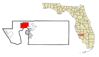
Grove City is an unincorporated community and census-designated place (CDP) in Charlotte County, Florida, United States. The population was 2,174 at the 2020 census, up from 1,804 at the 2010 census. It is part of the Punta Gorda, FL Metropolitan Statistical Area, included in the North Port-Bradenton, Florida Combined Statistical Area.

<span class="mw-page-title-main">Harbour Heights, Florida</span> Census-designated place in Florida, United States

Harbour Heights is a census-designated place (CDP) in Charlotte County, Florida, United States. The population was 3,428 at the 2020 census, up from 2,987 at the 2010 census. It is part of the Punta Gorda, Florida Metropolitan Statistical Area, included in the North Port-Bradenton, Florida Combined Statistical Area.

<span class="mw-page-title-main">Manasota Key, Florida</span> Census-designated place in Florida, United States

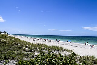
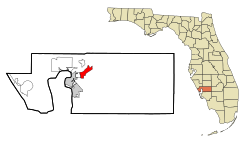
Manasota Key is a census-designated place (CDP) consisting mainly of the community of Englewood Beach in Charlotte County, Florida, United States. The population of the CDP was 1,326 at the 2020 census, up from 1,229 at the 2010 census. It is part of the Punta Gorda, Florida Metropolitan Statistical Area, included in the North Port-Bradenton, Florida Combined Statistical Area.

<span class="mw-page-title-main">Port Charlotte, Florida</span> Census-designated place in Florida, United States

Port Charlotte is an unincorporated community and census-designated place (CDP) in Charlotte County, Florida, United States. The population was 60,625 at the 2020 census, up from 54,392 at the 2010 census. It is part of the Punta Gorda, Florida Metropolitan Statistical Area, included in the North Port-Bradenton, Florida Combined Statistical Area.

<span class="mw-page-title-main">Solana, Florida</span> Census-designated place in Florida, United States

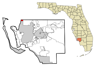
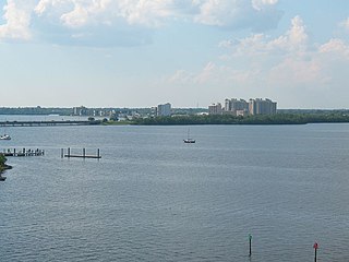
Solana is an unincorporated community and census-designated place (CDP) in Charlotte County, Florida, United States. The population was 671 at the 2020 census, down from 742 at the 2010 census. It is part of the Punta Gorda, Florida Metropolitan Statistical Area, included in the North Port-Bradenton, Florida Combined Statistical Area.

<span class="mw-page-title-main">Burnt Store Marina, Florida</span> Census-designated place in Florida, United States

Burnt Store Marina is an unincorporated community and census-designated place (CDP) in Lee County, Florida, United States. The population was 1,890 at the 2020 census, up from 1,793 at the 2010 census. It is part of the Cape Coral-Fort Myers, Florida Metropolitan Statistical Area.

<span class="mw-page-title-main">Iona, Florida</span> Census-designated place in Florida, United States

Iona is an unincorporated community and census-designated place (CDP) in Lee County, Florida, United States. The population was 16,908 at the 2020 census, up from 15,404 at the 2010 census. It is part of the Cape Coral-Fort Myers, Florida Metropolitan Statistical Area.

<span class="mw-page-title-main">North Fort Myers, Florida</span> Census-designated place in Florida, United States

North Fort Myers is an unincorporated area and census-designated place (CDP) in Lee County, Florida, United States. The population was 42,719 at the 2020 census, up from 39,407 at the 2010 census. It is part of the Cape Coral-Fort Myers, Florida Metropolitan Statistical Area.

<span class="mw-page-title-main">Fairview Shores, Florida</span> Census-designated place in Florida, United States

Fairview Shores is a census-designated place and an unincorporated area in Orange County, Florida, United States. The population was 10,239 at the 2010 census. It is part of the Orlando–Kissimmee–Sanford, Florida Metropolitan Statistical Area.

<span class="mw-page-title-main">South Haven, Indiana</span> Census-designated place in Indiana, United States

South Haven is a census-designated place in Portage Township, Porter County, in the U.S. state of Indiana. The population was 5,282 at the 2010 census.

<span class="mw-page-title-main">Brookmont, Maryland</span> Census-designated place in Maryland, United States

Brookmont is a census-designated place and unincorporated area in Montgomery County, Maryland, United States. As of the 2020 census, it had a population of 3,751. Brookmont is often considered part of neighboring Bethesda because it falls within Bethesda's 20816 zip code.

<span class="mw-page-title-main">Mattapoisett Center, Massachusetts</span> Census-designated place in Massachusetts, United States

Mattapoisett Center is a census-designated place (CDP) in the town of Mattapoisett in Plymouth County, Massachusetts. The population was 2,915 at the 2010 census.

<span class="mw-page-title-main">Castle Point, Missouri</span> Place in Missouri, United States

Castle Point is an unincorporated community and census-designated place (CDP) in St. Louis County, Missouri, United States. The population was 3,962 at the 2010 census.

<span class="mw-page-title-main">Leavittsburg, Ohio</span> Census-designated place in Ohio, United States

Leavittsburg is a census-designated place in Trumbull County, Ohio, United States. The population was 1,571 at the 2020 census. Located directly west of Warren, Ohio, it is part of the Youngstown–Warren metropolitan area.

Wade Hampton is a census-designated place (CDP) in Greenville County, South Carolina, United States. The population was 20,622 at the 2010 census. It is named for American Civil War general and South Carolina governor Wade Hampton.

<span class="mw-page-title-main">South Willard, Utah</span> CDP in Utah, United States

South Willard is a census-designated place (CDP) in Box Elder County, Utah, United States. The population was 1,571 at the 2010 census.

Enfield is a census-designated place (CDP) and the main village in the town of Enfield in Grafton County, New Hampshire, United States. The population of the CDP was 1,571 at the 2020 census, out of 4,465 in the entire town.

References

  1. "2020 U.S. Gazetteer Files". United States Census Bureau. Retrieved October 31, 2021.
  2. 1 2 "U.S. Census website". United States Census Bureau . Retrieved January 31, 2008.
  3. "US Board on Geographic Names". United States Geological Survey. October 25, 2007. Retrieved January 31, 2008.
  4. "US Gazetteer files: 2010, 2000, and 1990". United States Census Bureau. February 12, 2011. Retrieved April 23, 2011.
  5. "Geographic Identifiers: 2010 Demographic Profile Data (G001): Cleveland CDP, Florida". U.S. Census Bureau, American Factfinder. Archived from the original on February 12, 2020. Retrieved June 25, 2014.
  6. "Census of Population and Housing". Census.gov. Retrieved June 4, 2016.