The 1967 Atlantic hurricane season was the first Atlantic hurricane season to be part of the modern-day satellite era. With 13 named storms, it was an above average season in terms of named storms, slightly above average in terms of hurricanes (6), and below average in terms of major hurricanes, with only one; Beulah. The season began on June 1, 1967, and ended on November 30, 1967, which delimits the time boundaries when tropical cyclones in the North Atlantic Ocean typically form. The first depression originated on June 10, and the final storm – Heidi – lost tropical characteristics on October 31.
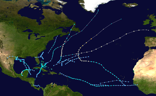
The 1973 Atlantic hurricane season was the first season to use the Saffir–Simpson hurricane scale, a scale developed in 1971 by Herbert Saffir and Robert Simpson to rate the intensity of tropical cyclones. The season produced 24 tropical and subtropical cyclones, of which only 8 reached storm intensity, 4 became hurricanes, and only 1 reached major hurricane status. Although more active than the 1972 season, 1973 brought few storms of note. Nearly half of the season's storms affected land, one of which resulted in severe damage.

Hurricane Charley was the second hurricane to threaten the East Coast of the United States within a year's timeframe, after Hurricane Gloria of 1985. The third tropical storm and second hurricane of the season, Charley formed as a subtropical low on August 13 along the Florida panhandle. After moving off the coast of South Carolina, the system transitioned into a tropical cyclone and intensified into a tropical storm on August 15. Charley later attained hurricane status before moving across eastern North Carolina. It gradually weakened over the north Atlantic Ocean before transitioning into an extratropical cyclone on August 20. Charley's remnants remained identifiable for over a week, until after crossing Ireland and Great Britain they dissipated on August 30.

Tropical Storm Nicholas was a long-lived tropical storm in October and November of the 2003 Atlantic hurricane season. Forming from a tropical wave on October 13 in the central tropical Atlantic Ocean, Nicholas developed slowly due to moderate levels of wind shear throughout its lifetime. Deep convection slowly organized, and Nicholas attained a peak intensity of 70 mph (110 km/h) on October 17. After moving west-northwestward for much of its lifetime, it turned northward and weakened due to increasing shear. The storm again turned to the west and briefly restrengthened, but after turning again to the north Nicholas transitioned to an extratropical cyclone on October 24. As an extratropical storm, Nicholas executed a large loop to the west, and after moving erratically for a week and organizing into a tropical low, it was absorbed by a non-tropical low. The low continued westward, crossed Florida, and ultimately dissipated over the Gulf Coast of the United States on November 5.

Hurricane Florence was the first North Atlantic hurricane to produce hurricane-force winds on the island of Bermuda since Hurricane Fabian in September 2003. The seventh tropical storm and second hurricane of the 2006 Atlantic hurricane season, Florence developed from a tropical wave in the eastern Atlantic Ocean on September 3. Due to unfavorable conditions, the system failed to organize initially, and as a result, the storm grew to an unusually large size. After several days, Florence encountered an area of lesser wind shear and intensified into a hurricane on September 10. It passed just west of Bermuda while recurving northeastward, and on September 13 it transitioned into an extratropical cyclone.

Hurricane Gordon was the first tropical cyclone since 1992 to affect the Azores while retaining tropical characteristics. The eighth tropical storm, third hurricane, and first major hurricane of the 2006 Atlantic hurricane season, Gordon formed on September 10 in the tropical Atlantic Ocean. It gradually matured into a hurricane as it tracked northward, reaching its peak intensity with winds of 195 km/h (121 mph) early on September 14 while located about 925 km (575 mi) southeast of Bermuda. After becoming nearly stationary, Gordon weakened to minimal hurricane status, although it re-intensified after accelerating to the east. It weakened again after moving over cooler waters, and passed through the Azores on September 20. Shortly thereafter, it became an extratropical cyclone and subsequently affected Spain, Ireland, and the United Kingdom.

Hurricane Karen was a hurricane of non-tropical origin that formed in October of the 2001 Atlantic hurricane season. It developed out of the interaction between a cold front and an upper level trough on October 10 located to the south of Bermuda, and quickly strengthened as an extratropical storm. The storm passed near Bermuda on October 12, producing hurricane-force winds on the island. It then organized, becoming a subtropical cyclone on October 12 and a tropical cyclone on October 13. Karen strengthened to reach 80 mph (130 km/h) winds as a Category 1 hurricane on the Saffir-Simpson Hurricane Scale, and after weakening over cooler waters, it made landfall on Nova Scotia as a tropical storm. It quickly became extratropical.

Tropical Storm Dean was a strong tropical storm that affected at least twelve islands along its path from the tropical Atlantic Ocean to east of Atlantic Canada in August 2001. Dean developed from a tropical wave on August 22 over the Lesser Antilles, and was initially predicted to intensify further to reach hurricane status. However, strong wind shear quickly weakened Dean to cause it to dissipate on August 23. The remnants turned northward, and redeveloped on August 26 to the north of Bermuda. Located over warm waters and in an area of favorable conditions, Dean steadily strengthened while moving to the northeast, and peaked just below hurricane status on August 27 about 465 miles (748 km) southwest of Newfoundland. The storm subsequently weakened over cooler waters, and became extratropical on August 28.

Hurricane Michael of the 2000 Atlantic hurricane season caused widespread, but relatively minor damage in Atlantic Canada. The seventeenth tropical cyclone, thirteenth named storm, and eighth hurricane of the season, Michael developed from a non-tropical system to the southwest of Bermuda on October 15. The system was initially subtropical, but rapidly acquired tropical characteristics by October 17. Michael quickly strengthened into a hurricane later that day. By October 20, Michael peaked as a Category 2 hurricane on the Saffir-Simpson hurricane wind scale at a relatively high latitude of 44°N. The storm weakened slightly to a Category 1 hurricane and became extratropical shortly before making landfall in Newfoundland on October 20.
The 2005 Azores subtropical storm was the 19th nameable storm and only subtropical storm of the extremely active 2005 Atlantic hurricane season. It was not named by the National Hurricane Center as it was operationally classified as an extratropical low. It developed in the eastern Atlantic Ocean, an unusual region for late-season tropical cyclogenesis. Nonetheless, the system was able to generate a well-defined centre convecting around a warm core on 4 October. The system was short-lived, crossing over the Azores later on 4 October before becoming extratropical again on 5 October. No damages or fatalities were reported during that time. Its remnants were soon absorbed into a cold front. That system went on to become Hurricane Vince, which affected the Iberian Peninsula.

Tropical Storm Chantal was a short-lived tropical storm that affected Bermuda in its formative stages and caused flooding and gusty winds in Newfoundland while extratropical. The third named storm of the 2007 Atlantic hurricane season, Chantal developed on July 31 from non-tropical origins between Bermuda and Cape Cod, and with favorable conditions, the storm rapidly attained peak winds of 50 mph (80 km/h). The storm accelerated northeastward over an area of progressively colder water temperatures, and after a decrease in convection the National Hurricane Center ceased issuing advisories as Chantal began undergoing extratropical transition early on August 1. Shortly thereafter, the extratropical remnant crossed over southeastern Newfoundland before tracking into the open waters of the north Atlantic Ocean. Prior to forming, the storm dropped moderate rainfall on Bermuda. Subsequent to becoming extratropical, the remnants of Chantal produced gusty winds and heavy precipitation across the Avalon Peninsula of Newfoundland, causing flooding and wind damage; insured damage totaled $25 million.
The 2006 Central Pacific cyclone, also known as Invest 91C or Storm 91C, was an unusual weather system that formed in 2006. Forming on October 30 from a mid-latitude cyclone in the north Pacific mid-latitudes, it moved over waters warmer than normal. The system acquired some features more typical of subtropical and even tropical cyclones. However, as it neared the western coastline of North America, the system fell apart, dissipating soon after landfall, on November 4. Moisture from the storm's remnants caused substantial rainfall in British Columbia and the Pacific Northwest. The exact status and nature of this weather event is unknown, with meteorologists and weather agencies having differing opinions.

Hurricane Florence attained Category 1 intensity on three separate occasions in mid-September 2000. The tenth tropical cyclone, sixth named storm, and third hurricane of the 2000 Atlantic hurricane season, Florence developed on September 10 from a cold front to the southwest of Bermuda. Initially a subtropical cyclone, it quickly organized, attaining hurricane status twice in a two-day period before weakening while remaining nearly stationary. Florence accelerated northeastward, reaching peak winds as a hurricane after passing near Bermuda. On September 17, the storm was absorbed by a larger extratropical cyclone. Hurricane Florence threatened Bermuda during its third time at hurricane intensity, bringing tropical storm force winds to the island but causing no reported damage. However, three deaths in North Carolina were blamed on rip currents triggered by the hurricane on September 12.

Tropical Storm Grace holds the record for being the farthest northeast forming tropical cyclone in the Atlantic basin. The seventh named storm of the slightly below average 2009 Atlantic hurricane season, Grace formed from an extratropical cyclone over the Azores on 4 October. It strengthened to attain peak sustained winds of 65 mph (100 km/h) and developed an eye-like feature, although cold sea surface temperatures inhibited the development of thunderstorm activity near the center. The storm lost its tropical characteristics on 6 October, and the storm's remnants merged with a separate system near the British Isles on 7 October.

The 1970 Canada hurricane was an unnamed tropical cyclone that brought impact to Bermuda and Newfoundland. The fourth hurricane and ninth tropical storm of the annual hurricane season, this system developed northeast of the Bahamas as a subtropical depression on October 12. While tracking northeastward, the system intensified, becoming a subtropical storm on the following day. The subtropical storm transitioned into a tropical cyclone on October 16, and strengthened into a hurricane about twelve hours later. The hurricane later bypassed Bermuda, before further intensifying into a Category 2 hurricane on the Saffir–Simpson hurricane wind scale. Thereafter, the hurricane accelerated rapidly northeastward, and made landfall on the Avalon Peninsula of Newfoundland as a Category 1 hurricane. It transitioned into an extratropical cyclone early on October 17.

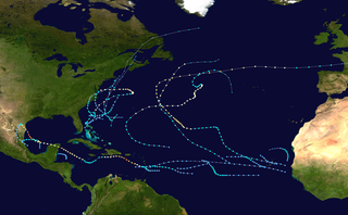
The 2016 Atlantic hurricane season was the deadliest Atlantic hurricane season since 2008, and the first above-average hurricane season since 2012, producing 15 named storms, 7 hurricanes and 4 major hurricanes. The season officially started on June 1 and ended on November 30, though the first storm, Hurricane Alex which formed in the Northeastern Atlantic, developed on January 12, being the first hurricane to develop in January since 1938. The final storm, Otto, crossed into the Eastern Pacific on November 25, a few days before the official end. Following Alex, Tropical Storm Bonnie brought flooding to South Carolina and portions of North Carolina. Tropical Storm Colin in early June brought minor flooding and wind damage to parts of the Southeastern United States, especially Florida. Hurricane Earl left 94 fatalities in the Dominican Republic and Mexico, 81 of which occurred in the latter. In early September, Hurricane Hermine, the first hurricane to make landfall in Florida since Hurricane Wilma in 2005, brought extensive coastal flooding damage especially to the Forgotten and Nature coasts of Florida. Hermine was responsible for five fatalities and about $550 million (2016 USD) in damage.

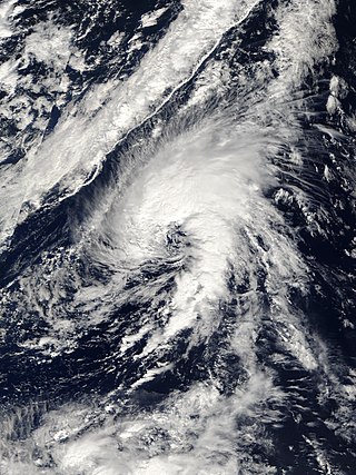
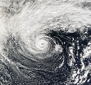
Hurricane Alex was the first Atlantic hurricane to occur in January since Hurricane Alice of 1954–55. Alex originated as a non-tropical low near the Bahamas on January 7, 2016. Initially traveling northeast, the system passed by Bermuda on January 8 before turning southeast and deepening. It briefly acquired hurricane-force winds by January 10, then weakened slightly before curving towards the east and later northeast. Acquiring more tropical weather characteristics over time, the system transitioned into a subtropical cyclone well south of the Azores on January 12, becoming the first North Atlantic tropical or subtropical cyclone in January since Tropical Storm Zeta of 2005–2006. Alex continued to develop tropical features while turning north-northeast, and transitioned into a fully tropical cyclone on January 14. The cyclone peaked in strength as a Category 1 hurricane on the Saffir–Simpson scale (SSHWS), with maximum sustained winds of 85 mph and a central pressure of 981 mbar. Alex weakened to a high-end tropical storm before making landfall on Terceira Island on January 15. By that time, the storm was losing its tropical characteristics; it fully transitioned back into a non-tropical cyclone several hours after moving away from the Azores. Alex ultimately merged with another cyclone over the Labrador Sea on January 17.


