The 2002 Atlantic hurricane season was a near-average Atlantic hurricane season. It officially started on June 1, 2002, and ended on November 30, dates which conventionally limit the period of each year when most tropical cyclones develop in the Atlantic Ocean. The season produced fourteen tropical cyclones, of which twelve developed into named storms; four became hurricanes, and two attained major hurricane status. While the season's first cyclone did not develop until July 14, activity quickly picked up: eight storms developed in the month of September. It ended early however, with no tropical storms forming after October 6—a rare occurrence caused partly by El Niño conditions. The most intense hurricane of the season was Hurricane Isidore with a minimum central pressure of 934 mbar, although Hurricane Lili attained higher winds and peaked at Category 4 whereas Isidore only reached Category 3. However, Lili had a minimum central pressure of 938 mbar.

The 2005 Atlantic hurricane season was the second-most active Atlantic hurricane season in history, with it being the most active until the record was broken 15 years later in 2020. The season broke numerous records at the time, with 28 tropical or subtropical storms recorded. The United States National Hurricane Center named 27 storms, exhausting the annual pre-designated list and resulting in the usage of six Greek letter names, and also identified an additional unnamed storm during a post-season re-analysis. A record 15 storms attained hurricane status, with maximum sustained winds of at least 74 miles per hour (119 km/h); of those, a record seven became major hurricanes, which are a Category 3 or higher on the Saffir–Simpson scale. Four storms of this season became Category 5 hurricanes, the highest ranking on the scale.

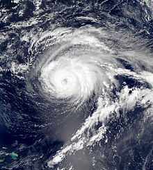
Hurricane Ophelia was a long-lived tropical cyclone in September 2005 that moved along an erratic path off the East Coast of the United States for much of its existence. The fifteenth named storm and the eighth hurricane of the record-breaking 2005 Atlantic hurricane season, Ophelia originated from a complex set of systems across the Atlantic in early September. An area of low pressure consolidated near the Bahamas and was classified as Tropical Depression Sixteen on September 6. Stuck in a region of meager steering currents, largely dominated by a lull between two ridges to the north and east, this system moved along a looping course with a general northward trajectory. The following day it organized into Tropical Storm Ophelia and soon reached hurricane status on September 8. Over the next week, Ophelia's intensity oscillated between tropical storm and hurricane levels due to intrusions of dry air, varying levels of wind shear, and gradual upwelling of cooler waters along its meandering path. Gradually growing in size, the system reached hurricane strength for the fourth time and its peak strength on September 14, with maximum sustained winds of 85 mph (140 km/h). By this time Ophelia had completed a second loop and was moving northwest toward North Carolina. Changing direction once again, the system turned away from the state though its eyewall scraped the coastline for two days. The system degraded to tropical storm strength for a final time on September 16 as it began accelerating northeast. Becoming embedded within the westerlies, Ophelia transitioned into an extratropical cyclone the next day. Remaining on a steady east-northeast to northeast path for the next week, Ophelia traversed Atlantic Canada and the northern Atlantic Ocean before dissipating on September 23 over the Norwegian Sea.

Tropical Storm Ana was the first named storm of the 2003 Atlantic hurricane season. A pre-season storm, it developed initially as a subtropical cyclone from a non-tropical low on April 20 to the west of Bermuda. It tracked east-southeastward and organized, and on April 21 it transitioned into a tropical cyclone with peak winds of 60 mph (97 km/h). Tropical Storm Ana turned east-northeastward, steadily weakening due to wind shear and an approaching cold front, and on April 24 it became an extratropical cyclone. The storm brushed Bermuda with light rain, and its remnants produced precipitation in the Azores and the United Kingdom. Swells generated by the storm capsized a boat along the Florida coastline, causing two fatalities.

Hurricane Gert was the fourth of five major hurricanes in the moderately active 1999 Atlantic hurricane season. A Cape Verde hurricane, Gert formed on September 11 off the coast of Africa before heading west-northwest. It reached a peak wind speed of 150 mph (240 km/h) by September 15 over the open central Atlantic east-northeast of the Leeward Islands. It gradually curved to the northwest and later to the north, due to a weakness in the subtropical ridge created by Hurricane Floyd. Hurricane Gert passed east of Bermuda on September 21 and began a steady weakening trend at that time. It turned to the northeast, and on September 23, Gert transitioned into an extratropical cyclone to the southeast of Atlantic Canada before being absorbed by a larger storm.

Hurricane Florence was the first North Atlantic hurricane to produce hurricane-force winds on the island of Bermuda since Hurricane Fabian in September 2003. The seventh tropical storm and second hurricane of the 2006 Atlantic hurricane season, Florence developed from a tropical wave in the eastern Atlantic Ocean on September 3. Due to unfavorable conditions, the system failed to organize initially, and as a result, the storm grew to an unusually large size. After several days, Florence encountered an area of lesser wind shear and intensified into a hurricane on September 10. It passed just west of Bermuda while recurving northeastward, and on September 13 it transitioned into an extratropical cyclone.

Tropical Storm Dean was a strong tropical storm that affected at least twelve islands along its path from the tropical Atlantic Ocean to east of Atlantic Canada in August 2001. Dean developed from a tropical wave on August 22 over the Lesser Antilles, and was initially predicted to intensify further to reach hurricane status. However, strong wind shear quickly weakened Dean to cause it to dissipate on August 23. The remnants turned northward, and redeveloped on August 26 to the north of Bermuda. Located over warm waters and in an area of favorable conditions, Dean steadily strengthened while moving to the northeast, and peaked just below hurricane status on August 27 about 465 miles (748 km) southwest of Newfoundland. The storm subsequently weakened over cooler waters, and became extratropical on August 28.

Hurricane Erin was the longest-lived hurricane in the 2001 Atlantic hurricane season. The sixth tropical depression, fifth tropical storm, and first hurricane of the season, Erin developed from a tropical wave on September 1. After strengthening to a 60 mph (97 km/h) tropical storm as it moved to the west-northwest, wind shear weakened Erin and caused it to degenerate into a remnant low on September 5. The remnants re-organized into a tropical depression the next day, and Erin strengthened into a hurricane on September 9 while moving northwestward. This was the latest date for the first hurricane of the season since Hurricane Diana on September 10, 1984. Erin quickly intensified and reached peak winds of 120 mph (190 km/h) later on September 9. At its closest approach, Erin passed 105 miles (169 km) east-northeast of Bermuda near peak intensity, and subsequently weakened as it turned to the east. A trough turned Erin to the northeast, and after passing just east of Cape Race, Newfoundland it became extratropical on September 15. The extratropical remnant continued northeastward and was absorbed into another extratropical storm near Greenland on September 17.

Tropical Storm Edouard was the first of eight named storms to form in September 2002, the most such storms in the North Atlantic for any month at the time. The fifth tropical storm of the 2002 Atlantic hurricane season, Edouard developed into a tropical cyclone on September 1 from an area of atmospheric convection associated with a cold front east of Florida. Under weak steering currents, Edouard drifted to the north and executed a clockwise loop to the west. Despite moderate to strong levels of wind shear, the storm reached a peak intensity of 65 mph (105 km/h) on September 3, but quickly weakened as it tracked westward. Edouard made landfall on northeastern Florida on September 5, and after crossing the state it dissipated on September 6 while becoming absorbed into the larger circulation of Tropical Storm Fay.
Hurricane Daniel was the second strongest hurricane of the 2006 Pacific hurricane season. The storm affected Hawaii late in its lifetime, causing moderate rainfall and minor damage. The fourth named storm, third hurricane, and second major hurricane of the season, Daniel originated on July 16 from a tropical wave off the coast of Mexico. It tracked westward, intensifying steadily to reach peak winds of 150 mph (240 km/h) on July 22. At the time, the characteristics of the cyclone resembled those of an annular hurricane. Daniel gradually weakened as it entered an area of cooler water temperatures and increased wind shear, and after crossing into the Central Pacific Ocean, it quickly degenerated into a remnant low on July 26, before dissipating two days later.

Hurricane Olga was the largest tropical cyclone by diameter of gale-force winds on record in the Atlantic at the time. The fifteenth named storm, ninth and final hurricane of the 2001 Atlantic hurricane season, Olga formed as a subtropical cyclone on November 24. After acquiring tropical characteristics later that day, Olga meandered westward, and eventually reached hurricane status on November 26. Olga peaked as a 90 mph (140 km/h) Category 1 hurricane before the storm turned southwestward and weakening back into a tropical storm. On November 30 it deteriorated further to a tropical depression, although it re-intensified two days later to tropical storm intensity. Olga then dissipated as a tropical cyclone on December 4 east of the Bahamas. Its damaging effects were limited to ships at sea. The cyclone's remnants produced heavy rainfall across the Bahamas and Florida. It was a relatively rare storm to exist in December, which is outside of the normal Atlantic hurricane season.

Tropical Storm Gabrielle was a short-lived tropical cyclone that passed over North Carolina before tracking out to sea. The seventh named storm of the 2007 Atlantic hurricane season, Gabrielle developed as a subtropical cyclone on September 8 about 385 miles (620 km) southeast of Cape Lookout, North Carolina. Unfavorable wind shear impacted the storm for much of its duration, although a temporary decrease in the shear allowed the cyclone to become a tropical storm. On September 9, Gabrielle made landfall at Cape Lookout National Seashore in the Outer Banks of North Carolina with winds of 60 mph (97 km/h). Turning to the northeast, the storm quickly weakened and dissipated on September 11.

Hurricane Isaac was a large and powerful Cape Verde hurricane that lasted through late September and early October 2000. The thirteenth tropical cyclone, ninth named storm, and the fifth hurricane of 2000 Atlantic hurricane season, Isaac developed from a tropical wave south of Cape Verde on September 21. The depression intensified, and on the following day, it was upgraded to Tropical Storm Isaac. Due to conductive atmospheric conditions, Isaac continued to strengthen, and attained hurricane intensity on September 23. Isaac managed to become a Category 3 hurricane on September 24, before steadily weakening shortly thereafter. By September 26, the storm had deteriorated to a Category 1 hurricane. However, it again encountered favorable conditions, which caused Isaac to re-intensify.

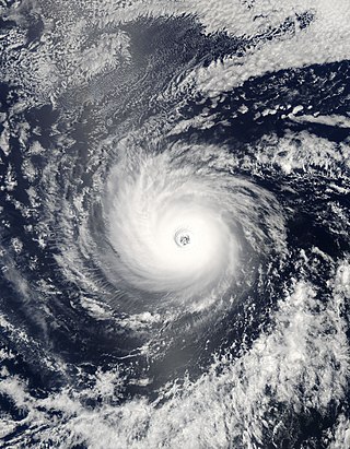
Hurricane Bertha was the longest-lived Atlantic tropical cyclone on record during July, as well as the furthest east system to attain tropical storm intensity during the month. The second named storm, first hurricane, and first major hurricane of the active 2008 season, Bertha developed into a tropical depression on July 3 from a tropical wave that departed western Africa two days prior. On a west-northwest to northwest track, the depression intensified into Tropical Storm Bertha six hours formation and ultimately attained hurricane intensity on July 7. A period of rapid deepening brought the cyclone to its peak as a Category 3 hurricane with winds of 125 mph (205 km/h) late that afternoon. Changes in wind shear and the storm's internal structure allowed Bertha to fluctuate in intensity over the next week as it passed very near Bermuda, but a track over cooler waters eventually caused the system to become an extratropical cyclone by July 20. It continued northeast and was absorbed by another low near Iceland the following day. Rough surf propelled by Bertha killed three people along the East Coast of the United States; hundreds of other swimmers were injured and/or required rescuing. In Bermuda, some streets were flooded and strong gusts cut power to approximately 7,500 homes; only minor damage was observed.

The 2006 Pacific hurricane season was the first above-average season since 1997 which produced twenty-five tropical cyclones, with nineteen named storms, though most were rather weak and short-lived. Only eleven hurricanes formed and six major hurricanes. Following the inactivity of the previous seasons, forecasters predicted that season would be only slightly above active. It was also the first time since 2003 in which at least one cyclone of tropical storm intensity made landfall. The season officially began on May 15 in the East Pacific Ocean, and on June 1 in the Central Pacific; they ended on November 30. These dates conventionally delimit the period of each year when most tropical cyclones form in the Pacific basin. However, the formation of tropical cyclones is possible at any time of the year.
The 2011 Atlantic hurricane season was the second in a group of three very active Atlantic hurricane seasons, each with 19 named storms. The above-average activity was mostly due to a La Niña that persisted during the previous year. Of the season's 19 tropical storms, only seven strengthened into hurricanes, and only four of those became major hurricanes: Irene, Katia, Ophelia, and Rina. The season officially began on June 1 and ended on November 30, dates which conventionally delimit the period during each year in which most tropical cyclones develop in the Atlantic Ocean. However, the first tropical storm of the season, Arlene, did not develop until nearly a month later. The final system, Tropical Storm Sean, dissipated over the open Atlantic on November 11.

Hurricane Maria was a Category 1 hurricane that made landfall on the island of Newfoundland during September 2011. Originating from a tropical wave over the central Atlantic on September 6, Maria moved toward the west and slowly strengthened. While approaching the northern Leeward Islands, however, the system entered a region of higher vertical wind shear and cooler sea surface temperatures, causing it to degenerate into a low-pressure area. It slowly curved toward the north and northeast around the western periphery of the subtropical ridge, and regained tropical storm status on September 10. Maria further strengthened to attain hurricane status while making its closest approach to Bermuda. The cyclone attained peak winds of 80 mph (130 km/h) on September 16, but weakened thereafter because of an increase in wind shear and cooler sea surface temperatures. Maria made landfall on the southeastern coast of Newfoundland during the afternoon hours of September 16 before becoming absorbed by a frontal system later on that same day.

Hurricane Nadine was an erratic Category 1 hurricane that became the fourth-longest-lived Atlantic hurricane on record. As the fourteenth tropical cyclone and named storm of the 2012 Atlantic hurricane season, Nadine developed from a tropical wave traveling west of Cape Verde on September 10. On the following day, it had strengthened into Tropical Storm Nadine. After initially tracking northwestward, Nadine turned northward, well away from any landmass. Early on September 15, Nadine reached hurricane status as it was curving eastward. Soon after, an increase in vertical wind shear weakened Nadine and by September 16 it was back to a tropical storm. On the following day, the storm began moving northeastward and threatened the Azores but late on September 19, Nadine veered east-southeastward before reaching the islands. Nonetheless, the storm produced tropical storm force winds on a few islands. On September 21, the storm curved south-southeastward while south of the Azores. Later that day, Nadine transitioned into a extratropical low pressure area.

The 2017 Atlantic hurricane season was a devastating, extremely active Atlantic hurricane season and the costliest on record, with a damage total of at least $294.92 billion (USD). The season featured 17 named storms, 10 hurricanes, and 6 major hurricanes. Most of the season's damage was due to hurricanes Harvey, Irma, and Maria. Another notable hurricane, Nate, was the worst natural disaster in Costa Rican history. These four storm names were retired following the season due to the number of deaths and amount of damage they caused.

Hurricane Alex was the first Atlantic hurricane to occur in January since Hurricane Alice of 1954–55. Alex originated as a non-tropical low near the Bahamas on January 7, 2016. Initially traveling northeast, the system passed by Bermuda on January 8 before turning southeast and deepening. It briefly acquired hurricane-force winds by January 10, then weakened slightly before curving towards the east and later northeast. Acquiring more tropical weather characteristics over time, the system transitioned into a subtropical cyclone well south of the Azores on January 12, becoming the first North Atlantic tropical or subtropical cyclone in January since Tropical Storm Zeta of 2005–2006. Alex continued to develop tropical features while turning north-northeast, and transitioned into a fully tropical cyclone on January 14. The cyclone peaked in strength as a Category 1 hurricane on the Saffir–Simpson scale (SSHWS), with maximum sustained winds of 85 mph and a central pressure of 981 mbar. Alex weakened to a high-end tropical storm before making landfall on Terceira Island on January 15. By that time, the storm was losing its tropical characteristics; it fully transitioned back into a non-tropical cyclone several hours after moving away from the Azores. Alex ultimately merged with another cyclone over the Labrador Sea on January 17.