The 1999 Atlantic hurricane season was a fairly active season, mostly due to a persistent La Niña that developed in the latter half of 1998. It had five Category 4 hurricanes – the highest number recorded in a single season in the Atlantic basin, previously tied in 1933 and 1961, and later tied in 2005 and 2020. The season officially began on June 1, and ended on November 30. These dates conventionally delimit the period of each year when most tropical cyclones form in the Atlantic basin. The first storm, Arlene, formed on June 11 to the southeast of Bermuda. It meandered slowly for a week and caused no impact on land. Other tropical cyclones that did not affect land were Hurricane Cindy, Tropical Storm Emily, and Tropical Depression Twelve. Localized or otherwise minor damage occurred from Hurricanes Bret, Gert, and Jose, and tropical storms Harvey and Katrina.

The 1993 Atlantic hurricane season was a below average Atlantic hurricane season that produced ten tropical cyclones, eight tropical storms, four hurricanes, and one major hurricane. It officially started on June 1 and ended on November 30, dates which conventionally delimit the period during which most tropical cyclones form in the Atlantic Ocean. The first tropical cyclone, Tropical Depression One, developed on May 31, while the final storm, Tropical Depression Ten, dissipated on September 30, well before the average dissipation date of a season's last tropical cyclone; this represented the earliest end to the hurricane season in ten years. The most intense hurricane, Emily, was a Category 3 on the Saffir–Simpson Hurricane Scale that paralleled close to the North Carolina coastline causing minor damage and a few deaths before moving out to sea.

Hurricane Diana was a deadly tropical cyclone which landfall Mexico in August 1990. The fourth named storm and second hurricane of the season, Diana developed from a tropical wave in the southwestern Caribbean on August 4. Forming as a tropical depression, the system brushed Honduras before intensifying into a tropical storm the following day. Continuing to gradually strengthen, Diana made its first landfall in Mexico's Yucatán Peninsula as a strong tropical storm late on August 5. The cyclone weakened slightly due to land interaction, before emerging into the Bay of Campeche on August 6. Once over water, warm sea surface temperatures allowed Diana to quickly become a hurricane and later peak as a Category 2 on the Saffir–Simpson hurricane scale on August 7. Shortly thereafter, the storm made landfall near Tampico, Tamaulipas, with winds of 100 mph (160 km/h). Rapid weakening ensued once the storm moved over the high terrain of Mexico, with Diana diminishing to a tropical depression roughly 24 hours after moving onshore. The cyclone later emerged into the Gulf of California on August 9 shortly before dissipating. The remnant disturbance was monitored until losing its identity over Arizona on August 14.

The 2005 Atlantic hurricane season was the second-most active Atlantic hurricane season in history, with it being the most active until the record was broken 15 years later in 2020. The season broke numerous records at the time, with 28 tropical or subtropical storms recorded. The United States National Hurricane Center named 27 storms, exhausting the annual pre-designated list and resulting in the usage of six Greek letter names, and also identified an additional unnamed storm during a post-season re-analysis. A record 15 storms attained hurricane status, with maximum sustained winds of at least 74 miles per hour (119 km/h); of those, a record seven became major hurricanes, which are a Category 3 or higher on the Saffir–Simpson scale. Four storms of this season became Category 5 hurricanes, the highest ranking on the scale.

The 2003 Pacific hurricane season was the first season to feature no major hurricanes – storms of Category 3 intensity or higher on the Saffir–Simpson hurricane wind scale (SSHWS) – since 1977. The dates conventionally delimiting the period when most tropical cyclones form in the Pacific Ocean are May 15 in the Eastern Pacific Ocean and June 1 in the Central Pacific, with both seasons ending on November 30. The 2003 season featured 16 tropical storms between May 19 and October 26; 7 of these became hurricanes, which was then considered an average season. Damage across the basin reached US$129 million, and 23 people were killed by the storms.
The 2005 Atlantic hurricane season was an event in the annual tropical cyclone season in the north Atlantic Ocean. It was the second most active Atlantic hurricane season in recorded history, and the most extreme in the satellite era. Officially, the season began on June 1, 2005 and ended on November 30, 2005. These dates, adopted by convention, historically delimit the period in each year when most tropical systems form. The season's first storm, Tropical Storm Arlene, developed on June 8. The final storm, Tropical Storm Zeta, formed in late December and persisted until January 6, 2006. Zeta is only the second December Atlantic storm in recorded history to survive into January, joining Hurricane Alice in 1955.

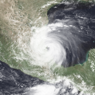
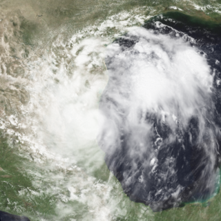
Hurricane Bret was the first of five Category 4 hurricanes that developed during the 1999 Atlantic hurricane season and the first tropical cyclone since Hurricane Jerry in 1989 to make landfall in Texas at hurricane intensity. Forming from a tropical wave on August 18, Bret slowly organized within weak steering currents in the Bay of Campeche. By August 20, the storm began to track northward and underwent rapid intensification on August 21. After this period of strengthening, Bret attained its peak intensity with winds of 145 miles per hour (233 km/h) and a barometric pressure of 944 mbar (hPa; 27.9 inHg). Later that day, the storm weakened to a Category 3 hurricane and made landfall on Padre Island, Texas. Shortly thereafter, the storm weakened further, becoming a tropical depression 24 hours after moving inland. The remnants of the storm eventually dissipated early on August 26 over northern Mexico.
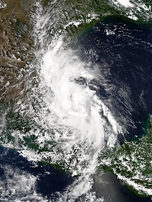
Hurricane Gert was a large tropical cyclone that caused extensive flooding and mudslides throughout Central America and Mexico in September 1993. The seventh named storm and third hurricane of the annual hurricane season, Gert originated as a tropical depression from a tropical wave over the southwestern Caribbean Sea on September 14. The next day, the cyclone briefly attained tropical storm strength before moving ashore in Nicaragua and proceeding through Honduras. It reorganized into a tropical storm over the Gulf of Honduras on September 17, but weakened back to a depression upon crossing the Yucatán Peninsula. Once over the warm waters of the Bay of Campeche, Gert quickly strengthened into a Category 2 hurricane by September 20. The hurricane made a final landfall on the Gulf Coast of Mexico near Tuxpan, Veracruz, with peak winds of 100 mph (160 km/h). The rugged terrain disrupted the cyclone's structure; Gert entered the Pacific Ocean as a depression near the state of Nayarit on September 21, where it briefly redeveloped a few strong thunderstorms before dissipating at sea five days later.

Tropical Storm Bret was a short-lived tropical storm in June 2005 that had damaging effects in Veracruz, Mexico. The second named storm of the season, Bret quickly developed from a tropical wave on June 28 in the Bay of Campeche. Failing to intensify beyond minimal tropical storm intensity, the system made landfall in Veracruz the following day. It rapidly weakened once onshore, dissipating early on June 30. The storm brought heavy rainfall to Veracruz, San Luis Potosí, and Tamaulipas with the former suffering the brunt of the impacts. Approximately 11,000 people were adversely affected by widespread flooding. A total of 2,129 homes were damaged and 25 were destroyed, mostly in the city of Naranjos. Three people were killed in storm-related incidents and total losses exceeded 100 million pesos (US$9.3 million). The Government of Veracruz declared emergencies for nine municipalities and released tens of millions of pesos in relief aid in conjunction with national agencies.
Tropical Storm Jose was a short-lived tropical storm which made landfall in central Mexico during August 2005. Jose was the tenth named storm of the 2005 Atlantic hurricane season and the fourth of six tropical cyclones to make landfall in Mexico in that year.
Hurricane Dolly caused flooding throughout Mexico in August 1996. The fourth named storm and third hurricane of the season, Dolly developed from a tropical wave to the west-southwest of Jamaica on August 19. Initially a tropical depression, the system strengthened into a tropical storm about twelve hours later. Dolly headed westward and intensified into a Category 1 hurricane late on August 20. It then made landfall near Chetumal, Quintana Roo. The system weakened to a tropical depression on August 21. Later that day or early on August 22, Dolly emerged into the Bay of Campeche and quickly re-strengthened into a tropical storm. The storm deepened further and was upgraded to a hurricane again by midday on August 23; Dolly simultaneously peaked with winds of 80 mph (130 km/h). Around that time, it struck between Tuxpan, Veracruz, and Tampico, Tamaulipas. Dolly quickly weakened to a tropical depression early on August 24, but remained intact while crossing Mexico and dissipated over the eastern Pacific Ocean on August 25.
Tropical Storm Gabrielle caused moderate flooding in northeastern Mexico and southern Texas in August 1995. The eighth tropical cyclone and seventh named storm of the 1995 Atlantic hurricane season, Gabrielle developed from a tropical wave in the west-central Gulf of Mexico on August 9. Initially a tropical depression, the system gradually intensified and by the following day, it became a tropical storm. Favorable conditions caused Gabrielle to continue to strengthen, with the storm nearly reaching hurricane status late on August 11. However, it soon made landfall near La Pesca, Tamaulipas, thus halting further intensification. Once inland, Gabrielle rapidly weakened and dissipated by early on August 12.

Hurricane Dolly was a strong tropical cyclone that made landfall in Deep South Texas in July 2008. Dolly was the fourth tropical cyclone and second hurricane to form during the 2008 Atlantic hurricane season. Dolly developed on July 20 from an area of disturbed weather in association with a strong tropical wave. It was named at the same time it formed, as the precursor wave already had tropical storm-force winds. This marked the earliest time a fourth named cyclone formed since the 2005 season, which used to hold the record until it was surpassed by the 2012 season, the 2016 season, and the 2020 season.
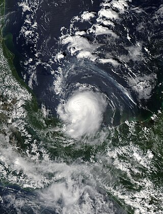
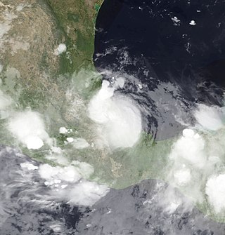
Tropical Storm Marco was the smallest tropical cyclone on record by radius of winds from center. The thirteenth named storm of the 2008 Atlantic hurricane season, Marco developed out of a broad area of low pressure over the northwestern Caribbean during late September 2008. Influenced by a tropical wave on October 4, a small low-level circulation center developed over Belize. After crossing the southern end of the Yucatán Peninsula and emerging into the Bay of Campeche, the low was declared Tropical Depression Thirteen early on October 6. The depression quickly intensified into a tropical storm and was given the name Marco later that day. Marco reached its peak intensity with winds of 65 mph (100 km/h) early on October 7. Around this time, tropical storm force winds extended 11.5 miles (18.5 km) from the center of the storm, making Marco the smallest tropical cyclone on record. Around 1200 UTC, Marco made landfall near Misantla, Veracruz. The storm rapidly weakened after landfall, dissipating later that day.

The 1983 Atlantic hurricane season was an event in the annual tropical cyclone season in the north Atlantic Ocean. It was the least active Atlantic hurricane season in 53 years, during which four storms formed. The season officially began on June 1, 1983 and ended November 30, 1983. These dates, adopted by convention, historically describe the period in each year when most systems form. The first named storm, Hurricane Alicia, formed on August 15. The last storm of the season, Tropical Storm Dean, dissipated on September 30.

The 2013 Atlantic hurricane season was a well below average Atlantic hurricane season in terms of the number of hurricanes. It was the first since 1994 with no major hurricanes, Category 3 or higher on the Saffir–Simpson scale, and the first in the satellite era where no hurricanes reached Category 2 strength. Altogether, the season produced 15 tropical cyclones, of which all but one became a named storm. The season officially began on June 1, 2013, and ended on November 30, 2013. These dates historically describe the period in each year when most tropical cyclogenesis occurs in the North Atlantic and are adopted by convention. The first storm of the season, Andrea, developed on June 5, while the last, an unnamed subtropical storm, dissipated on December 7. Throughout the year, only two storms, Humberto and Ingrid, reached hurricane strength; this was the lowest seasonal total since 1982.
The 2013 Atlantic hurricane season was an event in the annual hurricane season in the north Atlantic Ocean. It featured below-average tropical cyclone activity, with the fewest hurricanes since the 1982 season. The season officially began on June 1, 2013 and ended on November 30, 2013. These dates, adopted by convention, historically delimit the period in each year when most tropical systems form. The season's first storm, Tropical Storm Andrea formed on June 5, and its final storm, an unnamed subtropical storm, dissipated on December 7. Altogether, there were 13 named tropical storms during the season. Two of which attained hurricane strength, but neither intensified into a major hurricane, the first such occurrence since the 1994 season.

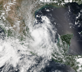
Hurricane Ingrid was one of two tropical cyclones, along with Hurricane Manuel, to strike Mexico within a 24-hour period, the first such occurrence since 1958. Ingrid was the ninth named storm and second hurricane of the 2013 Atlantic hurricane season. It formed on September 12 in the Gulf of Mexico from a broad disturbance that also spawned Manuel in the eastern Pacific. After initially moving westward toward Veracruz, Ingrid turned northeastward away from the coast. Favorable conditions allowed it to attain hurricane status on September 14, and the next day Ingrid attained peak winds of 140 km/h (85 mph). Subsequently, increased wind shear weakened the convection as the storm turned more to the northwest and west. On September 16, Ingrid made landfall just south of La Pesca, Tamaulipas in northeastern Mexico as a strong tropical storm, and dissipated the next day. The hurricane was also the last one to form in the Gulf of Mexico until Hurricane Hermine in 2016.
Tropical Storm Dolly was a short-lived and disorganized tropical cyclone that caused moderate damage across Tamaulipas, Mexico, in early September 2014. Originating from a tropical wave, the system first became a tropical depression late on September 1 while situated over the Bay of Campeche. Dolly struggled against strong wind shear for the duration of its existence. The large system featured multiple circulations, sometimes becoming a new dominant center and other times simply rotating around a mean vortex. As a result, multiple center relocations occurred along its general west-northwest track. Dolly eventually made landfall in Tamaulipas on September 3 before degenerating into a remnant low. The system subsequently dissipated the following day.

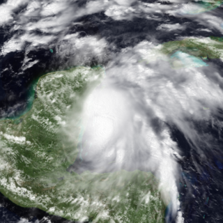
Hurricane Katia was a strong Atlantic hurricane which became the most intense storm to hit the Bay of Campeche since Karl in 2010. The eleventh named storm and sixth hurricane of the exceptionally active 2017 Atlantic hurricane season, Katia originated on September 5, out of a broad low-pressure area that formed in the Bay of Campeche. Located in an area of weak steering currents, Katia meandered around in the region, eventually intensifying into a hurricane on September 6. The nascent storm eventually peaked as a 105 mph (165 km/h) Category 2 hurricane on the Saffir–Simpson scale while it began to move southwestward. However, land interaction began to weaken the hurricane as it approached the Gulf Coast of Mexico. Early on September 9, Katia made landfall near Tecolutla at minimal hurricane intensity. The storm quickly dissipated several hours later, although its mid-level circulation remained intact and later spawned what would become Hurricane Otis in the Eastern Pacific.