The 2004 Atlantic hurricane season was a very deadly, destructive, and active Atlantic hurricane season, with over 3,200 deaths and more than $61 billion in damage. More than half of the 16 tropical cyclones brushed or struck the United States. Due to the development of a Modoki El Niño – a rare type of El Niño in which unfavorable conditions are produced over the eastern Pacific instead of the Atlantic basin due to warmer sea surface temperatures farther west along the equatorial Pacific – activity was above average. The season officially began on June 1 and ended on November 30, though the season's last storm, Otto, dissipated on December 3, extending the season beyond its traditional boundaries. The first storm, Alex, developed offshore of the Southeastern United States on July 31, one of the latest dates on record to see the formation of the first system in an Atlantic hurricane season. It brushed the Carolinas and the Mid-Atlantic, causing one death and $7.5 million (2004 USD) in damage. Several storms caused only minor damage, including tropical storms Bonnie, Earl, Hermine, and Matthew. In addition, hurricanes Danielle, Karl, and Lisa, Tropical Depression Ten, Subtropical Storm Nicole and Tropical Storm Otto had no effect on land while tropical cyclones. The season was the first to exceed 200 units in accumulated cyclone energy (ACE) since 1995, mostly from Hurricane Ivan, the storm produced the highest ACE. Ivan generated the second-highest ACE in the Atlantic, only behind 1899 San Ciriaco Hurricane.
The 2000 Atlantic hurricane season was a fairly active hurricane season, but featured the latest first named storm in a hurricane season since 1992. The hurricane season officially began on June 1, and ended on November 30. It was slightly above average due to a La Niña weather pattern although most of the storms were weak. It was also the only season to have two of the storms affect Ireland. The first cyclone, Tropical Depression One, developed in the southern Gulf of Mexico on June 7 and dissipated after an uneventful duration. However, it would be almost two months before the first named storm, Alberto, formed near Cape Verde; Alberto also dissipated with no effects on land. Several other tropical cyclones—Tropical Depression Two, Tropical Depression Four, Chris, Ernesto, Nadine, and an unnamed subtropical storm—did not impact land. Five additional storms—Tropical Depression Nine, Florence, Isaac, Joyce, and Leslie—minimally affected land areas.

The 1999 Atlantic hurricane season was a fairly active season, mostly due to a persistent La Niña that developed in the latter half of 1998. It had five Category 4 hurricanes – the highest number recorded in a single season in the Atlantic basin, previously tied in 1933 and 1961, and later tied in 2005 and 2020. The season officially began on June 1, and ended on November 30. These dates conventionally delimit the period of each year when most tropical cyclones form in the Atlantic basin. The first storm, Arlene, formed on June 11 to the southeast of Bermuda. It meandered slowly for a week and caused no impact on land. Other tropical cyclones that did not affect land were Hurricane Cindy, Tropical Storm Emily, and Tropical Depression Twelve. Localized or otherwise minor damage occurred from Hurricanes Bret, Gert, and Jose, and tropical storms Harvey and Katrina.

The 1981 Atlantic hurricane season featured direct or indirect impacts from nearly all of its 12 tropical or subtropical storms. Overall, the season was fairly active, with 22 tropical depressions, 12 of which became a namable storm, while 7 of those reached hurricane status and 3 intensified into major hurricanes. The season officially began on June 1, 1981, and lasted until November 30, 1981. These dates conventionally delimit the period of each year when most tropical cyclones form in the Atlantic basin. However, tropical cyclogenesis can occur before these dates, as demonstrated with the development of two tropical depressions in April and Tropical Storm Arlene in May. At least one tropical cyclone formed in each month between April and November, with the final system, Subtropical Storm Three, becoming extratropical on November 17, 1981.

The 1982 Atlantic hurricane season was an extremely inactive Atlantic hurricane season with five named tropical storms and one subtropical storm. Two storms became hurricanes, one of which reached major hurricane status. The season officially began on June 1, 1982, and lasted until November 30, 1982. These dates conventionally delimit the period of each year when most tropical cyclones form in the Atlantic basin. Activity started early with Hurricane Alberto forming on the first day of the season. Alberto threatened the Southwestern Florida coast as a tropical storm, meadering offshore in the southeastern Gulf of Mexico and causing 23 fatalities in Cuba. The next system, a subtropical storm, formed later in June and affected the same area as Alberto, causing $10 million in damage.

The 1986 Atlantic hurricane season was a very inactive season that produced 10 depressions, 6 named storms, 4 hurricanes, and no major hurricanes. The season officially began on June 1, 1986, and lasted until November 30, 1986. These dates conventionally delimit the period of each year when most tropical cyclones form in the Atlantic basin. During the 1986 season, the first subtropical depression formed in the first week of June, while the last tropical cyclone dissipated at the end of the third week of November. The 1986 season had lower than average activity because of an ongoing El Niño event, and was the least active season in the North Atlantic since the 1983 Atlantic hurricane season. This was also the first season since 1972 to have no major hurricanes.

The 2006 Atlantic hurricane season was the least active in the basin since 1997, with nine named storms as well as an additional unnamed tropical storm identified by the National Hurricane Center. 2006 was the first season since 2001 in which no hurricanes made landfall in the United States, and was the first since 1994 in which no tropical cyclones formed during October. Following the intense activity of 2003, 2004, and 2005, forecasters predicted that the 2006 season would be only slightly less active. Instead, it turned out to be a below average season, as activity was slowed by a rapidly forming moderate El Niño event, the presence of the Saharan Air Layer over the tropical Atlantic, and the steady presence of a robust secondary high-pressure area to the Azores High centered on Bermuda. There were no tropical cyclones after October 2.

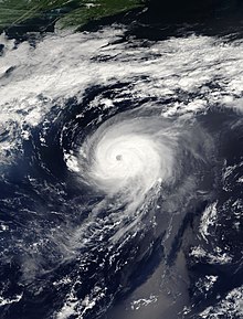
Hurricane Maria was an Atlantic hurricane which formed in September 2005 during the annual hurricane season. Maria was the thirteenth named storm, sixth hurricane, and fourth major hurricane of the record-breaking season. Maria formed in the central Atlantic on September 1 and tracked to the northwest, strengthening as it moved over warm waters. The storm reached its peak intensity on September 5 east of Bermuda and gradually weakened before becoming extratropical on September 10. Maria did not affect any land as a tropical cyclone, but Maria brought tropical storm-force winds to Iceland as an extratropical cyclone and produced heavy rain and three fatalities in Norway.
The 2006 Atlantic hurricane season was a cycle of the annual tropical cyclone season in the Atlantic Ocean in the Northern Hemisphere. The season officially began on June 1, 2006, and ended on November 30, 2006. These dates, adopted by convention, historically describe the period in each year when most subtropical or tropical cyclogenesis occurs in the Atlantic Ocean. The first storm to form in 2006 was Tropical Storm Alberto on June 10; the last, Hurricane Isaac, dissipated on October 2.

The 2003 Atlantic hurricane season was an active Atlantic hurricane season with tropical activity before and after the official bounds of the season – the first such occurrence in 33 years. The season officially began on June 1, 2003 and ended on November 30. However, a pre-season storm, Tropical Storm Ana, led to the season starting on April 20, and storm activity continued through December 11. The timeline includes information which was not operationally released, meaning that information from post-storm reviews by the National Hurricane Center, such as information on a storm that was not operationally warned upon, has been included. This timeline documents tropical cyclone formations, strengthening, weakening, landfalls, extratropical transitions, as well as dissipations during the season.

The 1983 Atlantic hurricane season was an event in the annual tropical cyclone season in the north Atlantic Ocean. It was the least active Atlantic hurricane season in 53 years, during which four storms formed. The season officially began on June 1, 1983 and ended November 30, 1983. These dates, adopted by convention, historically describe the period in each year when most systems form. The first named storm, Hurricane Alicia, formed on August 15. The last storm of the season, Tropical Storm Dean, dissipated on September 30.
The 1982 Atlantic hurricane season was an event in the annual tropical cyclone season in the north Atlantic Ocean. It was an inactive Atlantic hurricane season, during which only five tropical cyclones formed. The season officially began on June 1, 1982 and ended November 30, 1982. These dates, adopted by convention, historically describe the period in each year when most systems form. this year, however, most tropical activity was constrained to the month of September.

Hurricane Humberto was a moderately powerful hurricane that briefly affected Bermuda in September 2001. It was the eighth named storm of the season, as well as the fourth hurricane. It formed on September 21 between Puerto Rico and Bermuda, partially related to previous Hurricane Gabrielle. Humberto passed about 140 miles (230 km) west of Bermuda, which spared the island with its strongest winds. After weakening and believed to be on the verge of dissipating, Humberto unexpectedly restrengthened to the southeast of Atlantic Canada. The intensification was short-lived and the storm dissipated on September 27. There were a series of significant observational flights into the hurricane that produced a wealth of data on the structure of hurricanes.

The 2009 Atlantic hurricane season was an event in the annual tropical cyclone season in the north Atlantic Ocean. It was below-average Atlantic hurricane season with nine named storms, the fewest since the 1997 season. The season officially began on June 1, 2009, and ended on November 30, 2009, dates that conventionally delimit the period of each year when most tropical cyclones develop in the Atlantic basin. The first storm to form was Tropical Depression One on May 28, 2009, while the last storm, Hurricane Ida, dissipated on November 10.

The 1987 Atlantic hurricane season was an event in the annual Atlantic hurricane season in the north Atlantic Ocean. It was a below-average season, having fewer named storms than in a normal year, that resulted in little impact throughout the Atlantic basin; the United States recorded no hurricane-related fatalities, making the 1987 season the fourth to do so since 1976. The season officially began on June 1, 1987 and ended November 30, 1987. These dates, adopted by convention, historically describe the period in each year when most systems form. Even so, a pre-season storm, Tropical Depression One, led to the season's starting on May 25. Storm activity ended several weeks early; the final storm of the season, Tropical Depression Fourteen, dissipated on November 4.
The 2009 Atlantic hurricane season was a near-average Atlantic hurricane season that produced eleven tropical cyclones, nine named storms, three hurricanes, and two major hurricanes. It officially began on June 1 and ended on November 30, dates that conventionally delimit the period of each year when most tropical cyclones develop in the Atlantic basin. The season's first tropical cyclone, Tropical Depression One, developed on May 28, while the final storm, Hurricane Ida, dissipated on November 10. The most intense hurricane, Bill, was a powerful Cape Verde-type hurricane that affected areas from the Leeward Islands to Newfoundland. The season featured the lowest number of tropical cyclones since the 1997 season, and only one system, Claudette, made landfall in the United States. Forming from the interaction of a tropical wave and an upper-level low, Claudette made landfall on the Florida Panhandle with maximum sustained winds of 45 mph (70 km/h) before quickly dissipating over Alabama. The storm killed two people and caused $228,000 in damage.

The 2015 Atlantic hurricane season was the last of three consecutive below average Atlantic hurricane seasons. It produced twelve tropical cyclones, eleven named storms, four hurricanes, and two major hurricanes. The Accumulated Cyclone Energy (ACE) for the season was 68% of the long-term median value. The hurricane season officially began on June 1, 2015, and ended on November 30, 2015. These dates historically describe the period each year when most tropical cyclones form in the North Atlantic basin. However, the first named storm, Ana, developed on May 8, nearly a month before the official start of the season, the first pre-season cyclone since Beryl in 2012 and the earliest since Ana in 2003. The formation of Ana marked the start of a series of seven consecutive seasons with pre-season activity, spanning from 2015 to 2021. The season concluded with Kate transitioning into an extratropical cyclone on November 11, almost three weeks before the official end.
The 2011 Atlantic hurricane season was an event in the annual hurricane season in the north Atlantic Ocean. It was well above average, with 19 tropical storms forming. Even so, it was the first season on record in which the first eight storms failed to attain hurricane strength. The season officially began on June 1, 2011, and ended on November 30, 2011, dates that conventionally delimit the period of each year when most tropical cyclones develop in the Atlantic basin. The season's first storm, Tropical Storm Arlene did not form until June 28. The final storm to develop, Tropical Storm Sean, dissipated on November 11.

The 2012 Atlantic hurricane season was an event in the annual hurricane season in the north Atlantic Ocean. For the third year in a row there were 19 named storms. The season officially began on June 1, 2012, and ended on November 30, 2012, dates that conventionally delimit the period of each year when most tropical cyclones develop in the Atlantic basin. Surprisingly, two preseason storms formed: Alberto on May 19, and Beryl on May 26. This was the first such occurrence since the 1951 season. The final storm to dissipate was Sandy, on October 29. Altogether, ten storms became hurricanes, of which two intensified into major hurricanes.

The 2013 Atlantic hurricane season was an event in the annual hurricane season in the north Atlantic Ocean. It featured below-average tropical cyclone activity, with the fewest hurricanes since the 1982 season. The season officially began on June 1, 2013 and ended on November 30, 2013. These dates, adopted by convention, historically delimit the period in each year when most tropical systems form. The season's first storm, Tropical Storm Andrea formed on June 5, and its final storm, an unnamed subtropical storm, dissipated on December 7. Altogether, there were 13 named tropical storms during the season. Two of which attained hurricane strength, but neither intensified into a major hurricane, the first such occurrence since the 1994 season.