1881 Atlantic hurricane season

Last updated

1881 Atlantic hurricane season
1881 Atlantic hurricane season summary map.png
Season summary map
Seasonal boundaries
First system formedAugust 1, 1881
Last system dissipatedSeptember 24, 1881
Strongest storm
NameFive
  Maximum winds105 mph (165 km/h)
(1-minute sustained)
  Lowest pressure970 mbar (hPa; 28.64 inHg)
Seasonal statistics
Total storms7
Hurricanes4
Major hurricanes
(Cat. 3+)
0
Total fatalities700
Total damageUnknown
Atlantic hurricane seasons
1879, 1880, 1881, 1882, 1883

The 1881 Atlantic hurricane season ran through the summer and early fall of 1881. This is the period of each year when most tropical cyclones form in the Atlantic basin. In the 1881 Atlantic season there were three tropical storms and four hurricanes, none of which became major hurricanes (Category 3+). However, in the absence of modern satellite and other remote-sensing technologies, only storms that affected populated land areas or encountered ships at sea were recorded, so the actual total could be higher. An undercount bias of zero to six tropical cyclones per year between 1851 and 1885 and zero to four per year between 1886 and 1910 has been estimated. [1] Of the known 1881 cyclones, Hurricane Three and Tropical Storm Seven were both first documented in 1996 by Jose Fernandez-Partagas and Henry Diaz. They also proposed changes to the known tracks of Hurricane Four and Hurricane Five. [2]

Contents

Season Summary

The Atlantic hurricane database (HURDAT) recognizes seven tropical cyclones for the 1881 season. In the 1881 Atlantic season there were three tropical storms, two Category 1 hurricanes and two Category 2 hurricanes. Five of these storms were active in August and two in September. No major hurricanes, Category 3 or greater, are known for this year. Tropical Storm One impacted Mississippi in the first week of August. Later that month, Tropical Storm Two hit Corpus Christi, Texas. At the same time in mid-August, Hurricane Three, a Category 1 hurricane was active in the tropical Atlantic without making a landfall anywhere. A tropical storm developed into Hurricane Four, a Category 1 hurricane, on August 19 north-east of the Bahamas. It became extratropical on August 21. [3] Hurricane Five was the most destructive storm of 1881. It impacted the Georgia coast on August 27 as a Category 2 hurricane and was responsible for a large loss of life. Hurricane Six was a Category 2 hurricane that uprooted trees and demolished several buildings across North Carolina and Virginia in September. The last storm of the year was Tropical Storm Seven. It was active between September 18 and September 24, to the northwest of Bermuda, without making landfall.

Timeline

Saffir–Simpson Hurricane Scale1881 Atlantic hurricane season

Systems

Tropical Storm One

Tropical storm (SSHWS)
1881 Atlantic tropical storm 1 track.png  
DurationAugust 1 – August 4
Peak intensity60 mph (95 km/h) (1-min);

Observations suggest the presence of a tropical storm over the southern Gulf of Mexico on August 1. [2] The storm moved generally north-northwestward across the Gulf of Mexico before striking Dauphin Island, Alabama, and then near the Alabama-Mississippi state line on August 3 with winds of 60 mph (95 km/h). [3] An assessment of the storm by the Atlantic hurricane reanalysis project estimated that it weakened to a tropical depression early the following day, shortly before dissipating over east-central Mississippi. [4]

Heavy rains fell along the Gulf Coast of the United States, including up to 15.8 in (400 mm) from August 2 to August 5 in Pensacola, Florida. [2] Floodwaters reached 3 ft (0.91 m) above ground in the nearby community of Millview, forcing residents to evacuate. The storm also beached a few fishing smacks and the schooner Ella, which was loaded with a cargo of lumber. [5]

Tropical Storm Two

Tropical storm (SSHWS)
1881 Atlantic tropical storm 2 track.png  
DurationAugust 11 – August 14
Peak intensity45 mph (75 km/h) (1-min);

A tropical storm hit Corpus Christi, Texas in the middle of August, but caused no reported deaths. Signals were blown down at the harbor, and one boat was lost. [6] Climate researcher Michael Chenoweth could not confirm the existence of this system as a tropical cyclone, noting "No storm in Texas press accounts" and that Gordon E. Dunn and Banner I. Miller's 1960 reanalysis misdated a hurricane in 1880. [7]

Hurricane Three

Category 1 hurricane (SSHWS)
1881 Atlantic hurricane 3 track.png  
DurationAugust 11 – August 18
Peak intensity90 mph (150 km/h) (1-min);

From August 11 to August 16, a Category 1 hurricane existed in the tropical Atlantic before turning northward and weakening. It continued northward as a tropical storm throughout August 17 and 18. [3]

Hurricane Four

Category 1 hurricane (SSHWS)
1881 Atlantic hurricane 4 track.png  
DurationAugust 16 – August 21
Peak intensity80 mph (130 km/h) (1-min);

A tropical storm developed on August 16 off the eastern coast of the Yucatán Peninsula. It tracked northeastward throughout its lifetime, passing through Cuba, the Florida Keys, and the Bahamas before becoming a hurricane on August 19. It weakened to a tropical storm on August 21 and became extratropical the same day. [3]

Hurricane Five

Category 2 hurricane (SSHWS)
1881 Atlantic hurricane 5 track.png  
DurationAugust 21 – August 29
Peak intensity105 mph (165 km/h) (1-min);
970  mbar  (hPa)

The Georgia Hurricane of 1881

The Atlantic hurricane best track begins the path for this storm just east of the Lesser Antilles on August 21, one day before the cyclone passed north of the islands. Moving northwestward, the system intensified, reaching hurricane status early on August 24. The hurricane passed northeast of the Abaco Islands in the Bahamas two days later and strengthened into a Category 2 hurricane on the present-day Saffir–Simpson scale, peaking with maximum sustained winds of 105 mph (165 km/h). After moving north-northwestward late on August 26 and early the next day, the storm then turned west-northwestward. Around 02:00 UTC on August 28, the hurricane made landfall in Georgia between St. Simons Island and Savannah, likely at the same intensity. [3] Upon the cyclone moving ashore, the Atlantic hurricane reanalysis project estimated that it had a barometric pressure of 970 mbar (29 inHg). [4] Thereafter, the storm briefly moved westward and quickly weakened to a tropical storm within 10 hours of moving inland. By early on August 29, the system turned northwestward and weakened to a tropical depression later that day, before dissipating near the Arkansas-Mississippi state line. [3]

Between August 26 and August 27, the ship Sandusky encountered the storm, with the loss of all but two people, while most of the crew of the Hannah M. Lallis also drowned. [2] Landfall coincided with high tide and proved very destructive as several barrier islands were completely submerged by storm surge. [8] In Savannah, Georgia, few structures escaped damage, with the Monthly Weather Review noting that "nearly every house received a copious supply of salt water." in the Bohanville section of the city. A number of streets were blocked, especially by large trees and the remnants of tin roofs. Property damage in the city reached about $1.5 million. Approximately 100 ships capsized in the vicinity of Savannah. [9] A barometric recorded a pressure of 984.76 mbar (29.08 inHg), while a wind speed of 80 mph (130 km/h) was observed before the anemometer was destroyed. At least 335 people died in Savannah alone. [8] Tybee Island was also among the localities severely impacted. There, the storm demolished rows of cottages and even some of the sturdiest homes. Additionally, South Carolina experienced extensive coastal flooding. In Charleston, several feet of water submerged areas east of East Bay Street and inundated many properties in the southwest sections of city. Substantial damage to businesses, fences, roofs, telegraph wires, and trees were also reported. Damage in the city ranged from $200,000 to $300,000. [9] Overall, the storm caused an estimated 700 fatalities, making the hurricane among the deadliest to strike the United States. [10]

Deadliest United States hurricanes
RankHurricaneSeasonFatalities
1 4  "Galveston" 1900 8,000–12,000
2 4  "San Ciriaco" 1899 3,400
3 4  Maria 2017 2,981
4 5  "Okeechobee" 1928 2,823
5 4  "Cheniere Caminada" 1893 2,000
6 3  Katrina 2005 1,392
7 3  "Sea Islands" 1893 1,000–2,000
8 3  "Indianola" 1875 771
9 4  "Florida Keys" 1919 745
10 2  "Georgia" 1881 700
Reference: NOAA, GWU [11] [12] [nb 1]

Hurricane Six

Category 2 hurricane (SSHWS)
1881 Atlantic hurricane 6 track.png  
DurationSeptember 7 – September 11
Peak intensity105 mph (165 km/h) (1-min);
≤975  mbar  (hPa)

The Anne J. Palmer first encountered this storm on September 7 before capsizing in rough seas that day. [2] Thus, the track for this cyclone begins at that time to the northeast of the Turks and Caicos Islands as a Category 1 hurricane. Moving northeastward, the storm intensified slightly, becoming a Category 2 hurricane with winds of 105 mph (165 km/h) early on September 9, several hours prior to making landfall in present-day Oak Island, North Carolina. [3] The Atlantic hurricane reanalysis project estimated that upon landfall, the storm had a barometric pressure of 975 mbar (28.8 inHg). [4] Rapidly weakening to a tropical storm by early on September 10, the cyclone then turned northeastward, passing close to WilmingtonWrightsville Beach area and later near Norfolk, Virginia, before re-emerging into the Atlantic that day. The cyclone was last noted only 50 mi (80 km) offshore Massachusetts on September 11. [3]

An unknown number of deaths occurred when the Anne J. Palmer capsized, with only one person surviving. [2] In North Carolina, the storm uprooted trees and demolished buildings at both Smithville (present-day Southport) and Wilmington. An anemometer at Wilmington indicate sustained windspeeds of 90 mph (150 km/h) before it was destroyed. [13] At least 600 bushels of peanuts suffered damage after a warehouse lost its roof. Wilmington also entirely lost communications outside the city after winds toppled many telephone and telegraph wires. [14] Damage in North Carolina totaled approximately $100,000. [13] The hurricane weakened to a tropical storm over land, bringing heavy, yet beneficial, precipitation to other states, including the first rainfall in Washington, D.C. in 33 days. [15]

Tropical Storm Seven

Tropical storm (SSHWS)
1881 Atlantic tropical storm 7 track.png  
DurationSeptember 18 – September 22
Peak intensity70 mph (110 km/h) (1-min);

A tropical storm was first seen on September 18 to the northwest of Bermuda. It tracked to the northeast, reaching a peak of 70 mph (113 km/h) on the 19th while southeast of the Canadian Maritimes. It weakened over the north Atlantic, becoming extratropical on the 22nd and finally dissipating by September 24. [3]

See also

Notes

    1. The storm category color indicates the intensity of the hurricane when landfalling in the U.S.

    Related Research Articles

    <span class="mw-page-title-main">1929 Atlantic hurricane season</span>

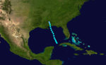
    The 1929 Atlantic hurricane season was among the least active Atlantic hurricane seasons on record, with only five tropical cyclones forming. Three of them intensified into a hurricane, with one strengthening further into a major hurricane. The first tropical cyclone of the season developed in the Gulf of Mexico on June 27. Becoming a hurricane on June 28, the storm struck Texas, bringing strong winds to a large area. Three fatalities were reported, while damage was conservatively estimated at $675,000 (1929 USD).

    <span class="mw-page-title-main">1909 Atlantic hurricane season</span>

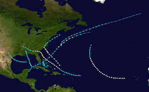
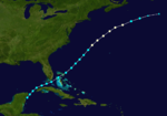
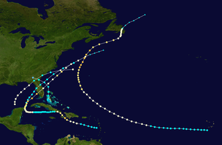
    The 1909 Atlantic hurricane season was an average Atlantic hurricane season. The season produced thirteen tropical cyclones, twelve of which became tropical storms; six became hurricanes, and four of those strengthened into major hurricanes. The season's first storm developed on June 15 while the last storm transitioned into an extratropical cyclone on November 14. The most notable storm during the season formed in late August, while east of the Lesser Antilles. The hurricane devastated the Lesser Antilles, the Greater Antilles, and Mexico, leaving around 4,000 fatalities and more than $50 million (1909 USD) in damage.

    <span class="mw-page-title-main">1899 Atlantic hurricane season</span>

    The 1899 Atlantic hurricane season featured the longest-lasting tropical cyclone in the Atlantic basin on record. There were nine tropical storms, of which five became hurricanes. Two of those strengthened into major hurricanes, which are Category 3 or higher on the modern day Saffir–Simpson scale. The first system was initially observed in the northeastern Gulf of Mexico on June 26. The tenth and final system dissipated near Bermuda on November 10. These dates fall within the period with the most tropical cyclone activity in the Atlantic. In post-season analysis, two tropical cyclones that existed in October were added to HURDAT – the official Atlantic hurricane database. At one point during the season, September 3 through the following day, a set of three tropical cyclones existed simultaneously.

    <span class="mw-page-title-main">1898 Atlantic hurricane season</span>

    The 1898 Atlantic hurricane season marked the beginning of the Weather Bureau operating a network of observation posts across the Caribbean Sea to track tropical cyclones, established primarily due to the onset of the Spanish–American War. A total of eleven tropical storms formed, five of which intensified into a hurricane, according to HURDAT, the National Hurricane Center's official database. Further, one cyclone strengthened into a major hurricane. However, in the absence of modern satellite and other remote-sensing technologies, only storms that affected populated land areas or encountered ships at sea were recorded, so the actual total could be higher. An undercount bias of zero to six tropical cyclones per year between 1851 and 1885 and zero to four per year between 1886 and 1910 has been estimated. The first system was initially observed on August 2 near West End in the Bahamas, while the eleventh and final storm dissipated on November 4 over the Mexican state of Veracruz.

    <span class="mw-page-title-main">1895 Atlantic hurricane season</span>

    The 1895 Atlantic hurricane season was a fairly inactive one, featuring only six known tropical cyclones, although each of them made landfall. Of those six systems, only two intensified a hurricane, while none of those strengthened into a major hurricane. However, in the absence of modern satellite and other remote-sensing technologies, only storms that affected populated land areas or encountered ships at sea were recorded, so the actual total could be higher. An undercount bias of zero to six tropical cyclones per year between 1851 and 1885 and zero to four per year between 1886 and 1910 has been estimated.

    <span class="mw-page-title-main">1893 Atlantic hurricane season</span>

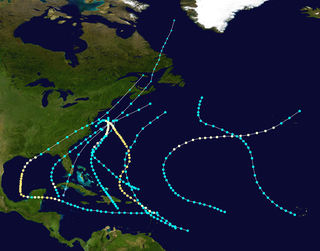
    The 1893 Atlantic hurricane season ran through the summer and the first half of fall in 1893. The 1893 season was fairly active, with 12 tropical storms forming, 10 of which became hurricanes. Of those, five became major hurricanes. This season proved to be a very deadly season, with two different hurricanes each causing over 2,000 deaths in the United States; at the time, the season was the deadliest in U.S. history. The season was one of two seasons on record to see four Atlantic hurricanes active simultaneously, along with the 1998 Atlantic hurricane season. Additionally, August 15, 1893 was the only time since the advent of modern record keeping that three storms have formed on the same day until 2020 saw Wilfred, Alpha, and Beta forming on the same day; and for the first time, there were two high-intensity hurricanes simultaneously in one month of August, and this was not repeated until the year 2023.

    <span class="mw-page-title-main">1891 Atlantic hurricane season</span>

    The 1891 Atlantic hurricane season began during the summer and ran through the late fall of 1891. The season had ten tropical cyclones. Seven of these became hurricanes; one becoming a major Category 3 hurricane.

    <span class="mw-page-title-main">1889 Atlantic hurricane season</span>

    The 1889 Atlantic hurricane season ran through the summer and the first half of fall in 1889. In the 1889 Atlantic season there were nine tropical storms and six hurricanes. However, due to scarce technology and the fact that only storms that affected populated land or ships were recorded, the actual total could be higher.

    <span class="mw-page-title-main">1884 Atlantic hurricane season</span>

    The 1884 Atlantic hurricane season was one of only three Atlantic hurricane seasons, along with 1852 and 1858, in which every known tropical cyclone attained hurricane status. Overall, four tropical cyclones developed, three of which made landfall. The first system was initially observed over the northwestern Atlantic Ocean on September 1. It struck Newfoundland the following day, but impact there is unknown. On September 3, the next hurricane developed, though it did not affect land in its duration. The third hurricane struck Georgia, accompanied by damaging waves in north Florida.

    <span class="mw-page-title-main">1880 Atlantic hurricane season</span>

    The 1880 Atlantic hurricane season ran through the summer and fall of 1880. This is the period of each year when most tropical cyclones form in the Atlantic basin. In the 1880 Atlantic season there were two tropical storms, seven hurricanes, and two major hurricanes (Category 3+). However, in the absence of modern satellite and other remote-sensing technologies, only storms that affected populated land areas or encountered ships at sea were recorded, so the actual total could be higher. An undercount bias of zero to six tropical cyclones per year between 1851 and 1885 and zero to four per year between 1886 and 1910 has been estimated. Of the known 1880 cyclones, Hurricane Six was first documented in 1995 by José Fernández-Partagás and Henry Díaz. They also proposed large changes to the known tracks of several other storms for this year and 're-instated' Hurricane Ten to the database. A preliminary reanalysis by Michael Chenoweth, published in 2014, found thirteen storms, nine hurricanes, and four major hurricanes.

    <span class="mw-page-title-main">1887 Atlantic hurricane season</span>

    The 1887 Atlantic hurricane season was the most active Atlantic hurricane season on record at the time in terms of the number of known tropical storms that had formed, with 19. This total has since been equaled or surpassed multiple times. The 1887 season featured five off-season storms, with tropical activity occurring as early as May, and as late as December. It is also worthy of note that the volume of recorded activity was documented largely without the benefit of modern technology. Tropical cyclones during this era did not approach populated areas or shipping lanes, especially if they were relatively weak and of short duration, may have remained undetected. Because technologies such as satellite monitoring were not available until the 1960s, historical data on tropical cyclones from this period may not be comprehensive. An undercount bias of zero to six tropical cyclones per year between 1851 and 1885 and zero to four per year between 1886 and 1910 has been estimated. Of the known 1887 cyclones, Tropical Storm One and Tropical Storm Three were first documented in 1996 by Jose Fernandez-Partagas and Henry Diaz. They also proposed large alterations to the known tracks of several of the other 1887 storms. Later re-analysis led to the known duration of Hurricane Six, and also that of Hurricane Fifteen, being increased.

    <span class="mw-page-title-main">1883 Atlantic hurricane season</span>

    The 1883 Atlantic hurricane season ran through the summer and the first half of fall in 1883. This is the period of each year when most tropical cyclones form in the Atlantic basin. In the 1883 Atlantic season there was one tropical storm, one Category 1 hurricane, and two major hurricanes. However, in the absence of modern satellite monitoring and remote-sensing technologies, only storms that affected populated land areas or encountered ships at sea were recorded, so the actual total could be higher. An undercount bias of zero to six tropical cyclones per year between 1851 and 1885 and zero to four per year between 1886 and 1910 has been estimated.

    <span class="mw-page-title-main">1854 Atlantic hurricane season</span>

    The 1854 Atlantic hurricane season featured five known tropical cyclones, three of which made landfall in the United States. At one time, another was believed to have existed near Galveston, Texas in September, but HURDAT – the official Atlantic hurricane database – now excludes this system. The first system, Hurricane One, was initially observed on June 25. The final storm, Hurricane Five, was last observed on October 22. These dates fall within the period with the most tropical cyclone activity in the Atlantic. No tropical cyclones during this season existed simultaneously. One tropical cyclone has a single known point in its track due to a sparsity of data.

    <span class="mw-page-title-main">1853 Atlantic hurricane season</span>

    The 1853 Atlantic hurricane season featured eight known tropical cyclones, none of which made landfall. Operationally, a ninth tropical storm was believed to have existed over the Dominican Republic on November 26, but HURDAT – the official Atlantic hurricane database – now excludes this system. The first system, Tropical Storm One, was initially observed on August 5. The final storm, Hurricane Eight, was last observed on October 22. These dates fall within the period with the most tropical cyclone activity in the Atlantic. At two points during the season, pairs of tropical cyclones existed simultaneously. Four of the cyclones only have a single known point in their tracks due to a sparsity of data, so storm summaries for those systems are unavailable.

    <span class="mw-page-title-main">1876 Atlantic hurricane season</span>

    The 1876 Atlantic hurricane season featured the first hurricane landfall in North Carolina since 1861. Overall, the season was relatively quiet, with five tropical storms developing. Four of these became a hurricane, of which two intensified into major hurricanes. However, due to the absence of remote-sensing satellite and other technology, only storms that affected populated land areas or encountered ships at sea were recorded; therefore, the actual total could be higher. An undercount bias of zero to six tropical cyclones per year between 1851 and 1885 and zero to four per year between 1886 and 1910 has been estimated.

    <span class="mw-page-title-main">1875 Atlantic hurricane season</span>

    The 1875 Atlantic hurricane season featured three landfalling tropical cyclones. However, in the absence of modern satellite and other remote-sensing technologies, only storms that affected populated land areas or encountered ships at sea were recorded, so the actual total could be higher. An undercount bias of zero to six tropical cyclones per year between 1851 and 1885 has been estimated. There were five recorded hurricanes and one major hurricane – Category 3 or higher on the modern-day Saffir–Simpson scale.

    <span class="mw-page-title-main">1871 Atlantic hurricane season</span>

    The 1871 Atlantic hurricane season lasted from mid-summer to late-fall. Records show that 1871 featured two tropical storms, four hurricanes and two major hurricanes. However, in the absence of modern satellite and other remote-sensing technologies, only storms that affected populated land areas or encountered ships at sea were recorded, so the actual total could be higher. According to a study in 2004, an undercount bias of zero to six tropical cyclones per year between 1851 and 1885 and zero to four per year between 1886 and 1910 is possible. A later study in 2008 estimated that eight or more storms may have been missed prior to 1878.

    <span class="mw-page-title-main">1873 Atlantic hurricane season</span>

    The 1873 Atlantic hurricane season was quiet, featuring only five known tropical cyclones, but all of them made landfall, causing significant impacts in some areas of the basin. Of these five systems, three intensified into a hurricane, while two of those attained major hurricane status. However, in the absence of modern satellite and other remote-sensing technologies, only storms that affected populated land areas or encountered ships at sea were recorded, so the actual total could be higher. An undercount bias of zero to six tropical cyclones per year between 1851 and 1885 and zero to four per year between 1886 and 1910 has been estimated.

    <span class="mw-page-title-main">1872 Atlantic hurricane season</span>

    The 1872 Atlantic hurricane season included a storm whose track became one of the first to be published by the United States Army Signal Service, a predecessor of the National Weather Service. The season was quiet, with only five documented tropical cyclones, of which four attained hurricane status. None of them intensified into a major hurricane. However, in the absence of modern satellite and other remote-sensing technologies, only storms that affected populated land areas or encountered ships at sea were recorded, so the actual total could be higher. An undercount bias of zero to six tropical cyclones per year between 1851 and 1885 and zero to four per year between 1886 and 1910 has been estimated.

    <span class="mw-page-title-main">1863 Atlantic hurricane season</span>

    The 1863 Atlantic hurricane season featured five landfalling tropical cyclones. In the absence of modern satellite and other remote-sensing technologies, only storms that affected populated land areas or encountered ships at sea were recorded, so the actual total could be higher. An undercount bias of zero to six tropical cyclones per year between 1851 and 1885 has been estimated. There were seven recorded hurricanes and no major hurricanes, which are Category 3 or higher on the modern day Saffir–Simpson scale. Of the known 1863 cyclones, seven were first documented in 1995 by José Fernández-Partagás and Henry Diaz, while the ninth tropical storm was first documented in 2003. These changes were largely adopted by the National Oceanic and Atmospheric Administration's Atlantic hurricane reanalysis in their updates to the Atlantic hurricane database (HURDAT), with some adjustments.

    References

    1. Landsea, C. W. (2004). "The Atlantic hurricane database re-analysis project: Documentation for the 1851–1910 alterations and additions to the HURDAT database". In Murname, R. J.; Liu, K.-B. (eds.). Hurricanes and Typhoons: Past, Present and Future. New York: Columbia University Press. pp. 177–221. ISBN   0-231-12388-4.
    2. 1 2 3 4 5 6 Partagas, J.F. and H.F. Diaz, 1996a "A reconstruction of historical Tropical Cyclone frequency in the Atlantic from documentary and other historical sources Part III: 1881–1890" Climate Diagnostics Center, NOAA, Boulder, Colorado
    3. 1 2 3 4 5 6 7 8 9 "Atlantic hurricane best track (HURDAT version 2)" (Database). United States National Hurricane Center. April 5, 2023. Retrieved June 2, 2024.PD-icon.svg This article incorporates text from this source, which is in the public domain.
    4. 1 2 3 Christopher W. Landsea; et al. (May 2015). "Documentation of Atlantic Tropical Cyclones Changes in HURDAT". National Hurricane Center, Hurricane Research Division. Retrieved April 3, 2024.
    5. "Storm at Pensacola". The Daily Picayune. New Orleans, Louisiana. August 6, 1881. p. 1. Retrieved April 22, 2024 via Newspapers.com. Lock-green.svg
    6. David Roth (2010-02-04). "Texas Hurricane History" (PDF). National Weather Service. Retrieved 2011-06-22.
    7. Chenoweth, Michael (December 2014). "A New Compilation of North Atlantic Tropical Cyclones, 1851–98". Journal of Climate . 27 (12). American Meteorological Society: 8682. Bibcode:2014JCli...27.8674C. doi: 10.1175/JCLI-D-13-00771.1 . Retrieved April 29, 2024.
    8. 1 2 Al Sandrik; Christopher W. Landsea (2003). "Chronological Listing of Tropical Cyclones affecting North Florida and Coastal Georgia 1565-1899". Hurricane Research Division. Archived from the original on December 6, 2006. Retrieved April 3, 2024.
    9. 1 2 "Barometric Pressure" (PDF). Monthly Weather Review. 9 (8). August 1881. Bibcode:1881MWRv....9RR..1.. doi:10.1175/1520-0493(1881)98[1b:BP]2.0.CO;2. Archived from the original (PDF) on March 3, 2017. Retrieved April 3, 2024.
    10. Edward N. Rappaport; José Fernández-Partagás (1996). "The Deadliest Atlantic Tropical Cyclones, 1492–1996: Cyclones with 25+ deaths". National Hurricane Center. Retrieved April 3, 2024.
    11. Blake, Eric S; Landsea, Christopher W; Gibney, Ethan J (August 10, 2011). The deadliest, costliest and most intense United States tropical cyclones from 1851 to 2010 (and other frequently requested hurricane facts) (PDF) (NOAA Technical Memorandum NWS NHC-6). National Oceanic and Atmospheric Administration. p. 47. Archived (PDF) from the original on May 17, 2024. Retrieved August 10, 2011.
    12. "Ascertainment of the Estimated Excess Mortality from Hurricane María in Puerto Rico" (PDF). Milken Institute of Public Health. August 27, 2018. Archived (PDF) from the original on August 29, 2018. Retrieved August 28, 2018.
    13. 1 2 Hudgins, James E. (April 2000). Tropical cyclones affecting North Carolina since 1586: An historical perspective. National Weather Service (Report). Blacksburg, Virginia: National Oceanic and Atmospheric Administration. p. 15-16. Retrieved April 21, 2023.
    14. "Yesterday's Hurricanes". The Morning Star. Wilmington, North Carolina. September 10, 1881. p. 1. Retrieved April 21, 2024 via Newspapers.com. Lock-green.svg
    15. Roth, David; Cobb, Hugh (July 16, 2001). "Late Nineteenth Century Virginia Hurricanes". Virginia Hurricane History (Report). National Oceanic and Atmospheric Administration. Archived from the original on January 8, 2008. Retrieved April 21, 2024.