Oak Island, North Carolina

Last updated

Oak Island, North Carolina
Oak Island NC (Early Morning).jpg
Oak Island Beach
Oak Island, NC Town Seal.jpg
Motto: 
"A Place to Coast"
USA North Carolina location map.svg
Red pog.svg
Oak Island
Location within the state of North Carolina
Usa edcp location map.svg
Red pog.svg
Oak Island
Oak Island (the United States)
Coordinates: 33°54′48″N78°05′29″W / 33.91333°N 78.09139°W / 33.91333; -78.09139
Country United States
State North Carolina
County Brunswick
Government
  MayorElizabeth White
Area
[1]
  Total20.63 sq mi (53.43 km2)
  Land19.27 sq mi (49.91 km2)
  Water1.36 sq mi (3.52 km2)
Elevation
[2]
16 ft (5 m)
Population
 (2020)
  Total8,396
  Estimate 
(2022) [3]
9,322
  Density435.66/sq mi (168.21/km2)
Time zone UTC-5 (Eastern (EST))
  Summer (DST) UTC-4 (EDT)
ZIP code
28465
Area codes 910, 472
FIPS code 37-48345
GNIS feature ID2407020 [2]
Website www.oakislandnc.com

Oak Island is a seaside town located in the southeastern corner of North Carolina, United States. Part of Brunswick County, the major portion of the town is on Oak Island which it shares with Caswell Beach. Founded in 1999 as the result of the consolidation of two existing towns, Oak Island's main industry is tourism. Per the 2020 census, the town has a permanent population of 8,396 while its summer population is near 50,000. [4] [5] It along with the town of Caswell Beach is part of the Wilmington, NC, Metropolitan Statistical Area. [6] [7]

Contents

History

Oak Island, on which much of the town sits, has been inhabited since the early 19th century when Fort Caswell was constructed on its east end in 1838. The island developed slowly, but by the late 1930s it began attracting people from nearby Southport with fox hunting popular in the areas along the Intracoastal Waterway (ICW). In 1954, Hurricane Hazel struck, leaving only five buildings standing on the west end of the island [8] The island recovered quickly however, and the towns of Long Beach and Yaupon Beach were incorporated. Along with this increasing level of development came strident demands for a reliable crossing of the ICW to provide access to the island.

Swain's Cut Bridge Swain's Cut Bridge.png
Swain's Cut Bridge

When the ICW was completed in the late 1930s, a swingbridge initially provided this service. Destroyed by a barge strike in 1971, construction of the high rise Barbee Bridge began almost immediately; it opened for traffic in 1975 (interim service included a ferry and pontoon bridge). [9] A second high rise structure, the Swain's Cut Bridge, was built over the ICW to the island in 2010. [10] In 1999, Long Beach and Yaupon Beach, decided to consolidate into the Town of Oak Island, and while Caswell Beach considered the matter, it opted to stay independent. [11] Immediately after the new town got up and running, it began to either incorporate or obtain Extra Territorial Jurisdiction (ETJ) on properties located to its north on the mainland. [12]

Geography

Oak Island Growth since 1999 Osk Island Land Use Plan (2017).jpg
Oak Island Growth since 1999

Oak Island is located in southeastern Brunswick County. According to the United States Census Bureau, the town has a total area of 19.9 square miles (51.6 km2), of which 18.5 square miles (48.0 km2) is land and 1.4 square miles (3.6 km2) (7.02%) is water. It is bordered to the south by the Atlantic Ocean, to the east by Caswell Beach, to the north across the ICW in part by the town of St. James, and to the west by the town of Holden Beach across the Lockwood Folly Inlet. Additions to the town in the 20 years since it was formed in 1999, located on the mainland, consist of the following: [12]

•Property on both sides of Long Beach Rd. (NC 133) to include the Cape Fear Regional Jetport, and South Harbour Village with its nine-hole golf course and marina. [13]

• Land mostly west of Middleton Blvd. (NC 906) either planned for or under development, the largest of which was the ill-fated Seawatch complex (1738 of the planned 4171 lots are in Oak Island). [14]

• Parcels north of Southport-Supply Rd. (NC 211), the most prominent being Midway Commons Shopping Center. [15]

Climate

Hurricane Hazel Marker Hurricane Hazel Historic Marker.png
Hurricane Hazel Marker

Summers in the town are hot and humid with an average temperature of 85˚, although the beach front is cooled much of the time by sea breezes (the prevailing winds are from the southwest). Ocean water temperatures range from the 50s in winter to the mid 80s in summer. Winters are moderate with an average temperature in the 50s (°F), albeit with brief cold periods. Rain occurs throughout the year with average annual rainfall approximately 57", 45% of this falling between June and September. [16] [17]

Tropical storms are a continuing source of concern with Hurricane Hazel being the most devastating. In the 1996-1999 period, four major hurricanes (Bertha, Fran, Bonnie, and Floyd) made landfall with Hurricane Floyd having significant effect on the town. [18] More recently, in October 2016, the eye of Hurricane Matthew passed almost directly over the town inflicting extensive damage to the dune system, [19] and in September 2018, Hurricane Florence caused severe flooding and wind damage in addition to washing away large amounts of beach sand. [20]

In the early morning hours of August 4, 2020, Hurricane Isaias hit Oak Island as a Category 1 hurricane; the storm surge was around 9 feet, increased by a corresponding high tide. The fishing pier and its hotel, many businesses, and hundreds of homes were damaged, and in many places sand from shoreside dunes was pushed inland for 3 blocks. An estimated 75-100 vehicles were damaged; floating cars were a common sight at the height of the storm. Power was finally cut off as a safety precaution. In the succeeding weeks, a mandatory evacuation order and damage to rental properties prevented tourism, which is a major source of income for many residents. [21]

Government

Oak Island Town Hall Oak Island Police Dept. & Town Hall.png
Oak Island Town Hall

The town government operates under a Council-Manager type system where various officials have authority to make decisions on services, revenues and expenditures in accordance with a state issued charter. The council is Oak Island's governing body and consists of five Commissioners and the Mayor. It sets the Town's policy, enacts ordinances and adopts the annual budget. The actual operation of the town's government is accomplished by the Town Manager who is hired by the council. [22] Town Hall is collocated in the center of the island with the Oak Island Police Department, while units of the Oak Island Fire Department and Brunswick County EMS are deployed in various areas of the Town to respond to emergencies [23]

Attractions

Oak Island Golf Club 18th green Oak Island Golf Club-18th Hole.png
Oak Island Golf Club 18th green
Ocean Crest Fishing Pier Oak Island NC-Fishing Pier.jpg
Ocean Crest Fishing Pier

Primarily a family beach type locale, the island also provides many other types of recreational activity. The Oak Island Golf Club course and its related practice facilities are open to the public and an outdoor swimming pool is available for its members' use during the summer. [24] Two public fishing piers jut out into the Atlantic Ocean [25] [26] while motor/sail boats moored to piers dot the ICW as well as the Davis Canal and Montgomery Slough. South Harbour Village has a nine-hole public golf course and a marina on the ICW with 1,000 linear feet of alongside dockage. [27] All these waterways also attract a large number of kayakers.

The Oak Island Recreation Center located mid-island provides both indoor and outdoor exercise facilities and rents out sports equipment and amenities like balloon tire, beach wheelchairs. [28] Popular sporting events include the "Run Oak Island" Marathon held in February which also features a half-marathon along with a 5K and one mile run. [29] And then in April, the Southport/Oak Island Chamber of Commerce sponsors the Oak Island Lighthouse Run which includes a half marathon, 10K, 5K and a one-mile fun run. [30]

As for other activities, the town puts on an ocean front fireworks display as part of its Fourth of July festivities, and a parade down Oak Island Drive just before Christmas, while the Oak Island Library hosts a wide variety of events to include "Socrates Cafe" and "Meet the Author" programs. [31]

Major highways

Demographics

Historical population
CensusPop.Note
2000 6,571
2010 6,7833.2%
2020 8,39623.8%
2021 (est.)8,878 [32] 5.7%
U.S. Decennial Census [33]

2020 census

Oak Island racial composition [34]
RaceNumberPercentage
White (non-Hispanic)7,78292.69%
Black or African American (non-Hispanic)680.81%
Native American 340.4%
Asian 430.51%
Pacific Islander 30.04%
Other/Mixed 3203.81%
Hispanic or Latino 1461.74%

As of the 2020 United States census, there were 8,396 people, 3,662 households, and 2,395 families residing in the town.

2017

As of 2017, the Census Bureau estimated 7,789 people lived in the town, roughly a 14% increase from 2010. The town's racial makeup was 97% White, 0.4% African American, 0.4% Native American, 2% Hispanic or Latino and 0.2% from two or more races. There were 3,605 households with the average size 2.05 persons. As for household income, the Census Bureau's 2017 estimate was $57,670, with the per capita income being $38,176. About 8.6% of the population were below the poverty line. That same year, the town's estimated population by age is as shown in the chart below. The ratio of women to men is 52.3% to 47.7%. [35]

Age GroupPercent of Population By Age
< 1812.5%
18 to 6556.8%
> 6530.7%

The fourth novel of North Carolina novelist Wiley Cash, When Ghosts Come Home, is a murder mystery set in Oak Island. [36]

Related Research Articles

<span class="mw-page-title-main">Brunswick County, North Carolina</span> County in North Carolina, United States

Brunswick County is a county located in the U.S. state of North Carolina. It is the southernmost county in the state. As of the 2020 census, the population was 136,693. Its population was only 73,143 in 2000, making it one of the fastest-growing counties in the state. With a nominal growth rate of approximately 47% in ten years, much of the growth is centered in the eastern section of the county in the suburbs of Wilmington such as Leland, Belville and Southport. The county seat is Bolivia, which at a population of around 150 people is among the least populous county seats in the state.

<span class="mw-page-title-main">Boiling Spring Lakes, North Carolina</span> City in North Carolina, United States

Boiling Spring Lakes is a city in Brunswick County, North Carolina, United States. The population was 5,943 at the 2020 census, up from 5,372 in 2010.

<span class="mw-page-title-main">Caswell Beach, North Carolina</span> Town in North Carolina, United States

Caswell Beach is a small seaside town located on the Atlantic Ocean at the mouth of the Cape Fear River in Southeastern North Carolina, United States. Occupying the eastern part of Oak Island in Brunswick County, its population was listed at 395 in the 2020 census. Prominent features include the Civil War era Fort Caswell, the Oak Island Lighthouse co-located with the Oak Island Coast Guard Station, and the Oak Island Golf Club, the sole business in town and one of the few eighteen-hole courses located on a North Carolina barrier island. Along with the Town of Oak Island which occupies the central and west parts of the island, Caswell Beach is part of the Wilmington, NC Metropolitan Statistical Area.

<span class="mw-page-title-main">Holden Beach, North Carolina</span> Seaside town in North Carolina, United States

Holden Beach is a seaside town in Brunswick County, North Carolina. The population was 575 at the time of the 2010 census. It is part of the Wilmington, NC Metropolitan Statistical Area.

<span class="mw-page-title-main">Ocean Isle Beach, North Carolina</span> Town in North Carolina, United States

Ocean Isle Beach is a small seaside town in Brunswick County, North Carolina, United States. It was incorporated as a town in 1959 and is part of the Wilmington, NC Metropolitan Statistical Area. The population was 867 at the 2020 census. Located at the southern end of North Carolina's Atlantic coastline, along the Atlantic Intracoastal Waterway, Ocean Isle Beach has private homes, seasonal rentals, and tourist attractions.

<span class="mw-page-title-main">Southport, North Carolina</span> City in North Carolina, United States

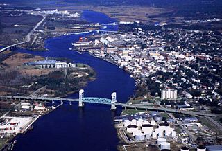
Southport is a city in Brunswick County, North Carolina, United States, near the mouth of the Cape Fear River. Its population was 3,828 as of the 2018 census. The current mayor, Rich Alt, was elected to a two-year term in November 2023.

<span class="mw-page-title-main">Sunset Beach, North Carolina</span> Town in North Carolina, United States

Sunset Beach is a seaside town in Brunswick County, North Carolina, United States. The population was 3,572 at the 2010 census, up from 1,824 in 2000 census. It is part of the Wilmington, NC Metropolitan Statistical Area.

<span class="mw-page-title-main">Yanceyville, North Carolina</span> Town in North Carolina, United States

Yanceyville is a town in and the county seat of Caswell County, North Carolina, United States. Located in the Piedmont Triad region of the state, the town had a population of 1,937 at the 2020 census.

<span class="mw-page-title-main">Nags Head, North Carolina</span> Town in North Carolina, United States

Nags Head is a town in Dare County, North Carolina, United States. It is a busy vacation spot because of its beaches and sand dunes of Jockey's Ridge. The population was 3,146 at the 2020 census.

<span class="mw-page-title-main">Wrightsville Beach, North Carolina</span> Town in North Carolina, United States

Wrightsville Beach is a town in New Hanover County, North Carolina, United States. Wrightsville Beach is just east of Wilmington and is part of the Wilmington Metropolitan Statistical Area. The population was 2,477 at the 2010 census. The town consists of a 4-mile (6 km) long beach island, an interior island called Harbor Island, and pockets of commercial property on the mainland. It served as a filming location of Dawson's Creek.

<span class="mw-page-title-main">Rodanthe, North Carolina</span> Census-designated place in North Carolina, United States

Rodanthe is an unincorporated community and census-designated place (CDP) located in Dare County, North Carolina, United States, on Hatteras Island, part of North Carolina's Outer Banks. As of the 2020 census it had a population of 213. Rodanthe, along with Waves and Salvo, are part of the settlement of Chicamacomico. Rodanthe includes the original Chicamacomico Life-Saving Station, decommissioned in 1954, but now a museum.

<span class="mw-page-title-main">Oak Island (North Carolina)</span>

Oak Island is located on the Atlantic Ocean coast in Brunswick County, North Carolina near the South Carolina border. A barrier island, it contains the towns of Oak Island and Caswell Beach, Fort Caswell and the Oak Island Coast Guard Station which is co-located with the Oak Island Lighthouse. Almost 13 miles long, the island averages about one mile wide. Approximately 7000 people live on it year-round, a number which can balloon to over 40,000 during the summer

<span class="mw-page-title-main">North Carolina Baptist Assembly</span>

The North Carolina Baptist Assembly is a Christian retreat owned and operated by the Baptist State Convention of North Carolina, the state's largest denomination. The grounds of the retreat, located adjacent to Caswell Beach on the eastern end of Oak Island, is the former site of Fort Caswell, a military base that was occupied by various branches of the U.S. armed forces for most of the period between 1836 and 1945. Most people still refer to the Baptist Assembly as Fort Caswell.

<span class="mw-page-title-main">Supply, North Carolina</span> Unincorporated community in North Carolina, United States

Supply is a small unincorporated community in Brunswick County, North Carolina, United States, located around the intersection of US 17 and NC 211. Its name is derived from the use of the Lockwoods Folly River as a trade route in the 18th and 19th centuries. Residents of the nearby beach communities of Holden Beach, Oak Island, Ocean Isle, Caswell Beach, and Sunset Beach often formerly commuted to Supply for goods and other materials. This practice is still common, but development in the town of Southport and in the Intracoastal Waterway commercial districts has made traveling to Supply unnecessary.

<span class="mw-page-title-main">Cape Fear (region)</span> Wilmington metropolitan area

Cape Fear is a coastal plain and Tidewater region of North Carolina centered about the city of Wilmington. The region takes its name from the adjacent Cape Fear headland, as does the Cape Fear River which flows through the region and empties into the Atlantic Ocean near the cape. Much of the region's populated areas are found along the Atlantic beaches and the Atlantic Intracoastal Waterway, while the rural areas are dominated by farms and swampland like that of the Green Swamp. The general area can be also identified by the titles "Lower Cape Fear", "Wilmington, NC Metropolitan Statistical Area", "Southeastern North Carolina", and "Azalea Coast". The latter name is derived from the North Carolina Azalea Festival held annually in Wilmington. Municipalities in the area belong to the Cape Fear Council of Governments.

Smithville Township is one of six townships within Brunswick County, North Carolina, United States. As of the 2000 Census, Smithville Township had a population of 12,019 and a population density of 152 inhabitants per square mile (59/km2). It is a part of the Wilmington, NC Metropolitan Statistical Area.

<span class="mw-page-title-main">Fort Caswell Historic District</span> Historic district in North Carolina, United States

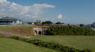
Located in North Carolina on the Atlantic Coast, the Fort Caswell Historic District encompasses 2 sites, 43 buildings, and 23 structures; it was added to the National Register of Historic Places in 2013. The fort itself was occupied by various branches of the U.S. armed forces for most of the period between 1836 and 1945 and is now a part of the North Carolina Baptist Assembly, a Christian retreat, owned and operated by the Baptist State Convention of North Carolina. It is accessible by the public to a limited extent per the conditions set forth by the Assembly’s Director.

<span class="mw-page-title-main">Oak Island Golf Club</span>

The Oak Island Golf Club (OIGC) is located in Caswell Beach NC on the south side of Oak Island looking out at the Atlantic Ocean. Part of the Lower Cape Fear region in Brunswick County, Southeast North Carolina, it is one of the few 18 holes golf courses built on a barrier island. The privately owned 6,720 yard, par 72 course is open to the public and has 37 bunkers with water in play on 11 holes. Laid out with five sets of tees which present a wide range of playability, the back (blue) tees are course rated at 73.1 with a slope of 139. A pro shop/pub/snack bar along with a full practice facility to include a sand trap, both putting and pitching greens, and a driving range is also available to the public.

<span class="mw-page-title-main">Coast Guard Station Oak Island</span> US Coast Guard station in North Carolina

Coast Guard Station Oak Island referred to locally as the Oak Island Coast Guard Station (OICGS) is located in the Town of Caswell Beach on Oak Island in Brunswick County, North Carolina. A part of the Cape Fear region, the station is in the United States Coast Guard 5th District which is charged with ensuring the safety and security of the oceans, coastal areas, and marine transportation system within the Mid-Atlantic Region. The district encompasses some 156,000 square miles of ocean, bays, rivers, wetlands and tidal marshes, geographic waterways, several major mid-Atlantic ports, and the Nation's capital. They also patrol the mouth of the Cape Fear River in Southport, North Carolina and the Intracoastal Waterway (ICW)

We're Crabby About Drilling is an advocacy group formed by citizens living on Oak Island, North Carolina, focused on preventing off-shore drilling and seismic testing. Known locally as the "Oak Island Crabbies" the group is opposed to the federal government's proposed plan for ocean drilling and seismic blasting in the Cape Fear littoral as set forth in the Bureau of Ocean Energy Management (BOEM) Draft Proposed Program for 2019-2104.

References

  1. "ArcGIS REST Services Directory". United States Census Bureau. Retrieved September 20, 2022.
  2. 1 2 U.S. Geological Survey Geographic Names Information System: Oak Island, North Carolina
  3. "QuickFacts: Oak Island town, North Carolina". United States Census Bureau. Retrieved May 21, 2023.
  4. "Residents & Visitors | Oak Island, NC". www.oakislandnc.gov. Retrieved April 11, 2023.
  5. "'Significant step forward': OKI chooses vendor for paid parking". Port City Daily. December 15, 2022.
  6. "U.S. Census website". US Census.gov. Retrieved February 4, 2019.
  7. Still, Johanna F. (July 21, 2023). "Brunswick back in Wilmington MSA". WilmingtonBiz. Retrieved July 26, 2023.
  8. Gifford, Jim (2004). Hurricane Hazel: Canada's Storm of the Century. Toronto: Dundurn Press. p. 22. ISBN   1-55002-526-0.
  9. Furstenau, Wolfgang (1995). Long Beach. Long Beach, NC: Furstenau. ISBN   978-09648233-0-3.
  10. "Swain's Cut Bridge". StarNews.com. Retrieved January 17, 2019.
  11. "Oak Island Consolidation" (PDF). NC.gov. Retrieved January 15, 2019.
  12. 1 2 "Oak Island Land Use Plan" (PDF). Oak Island.com. Retrieved February 4, 2019.
  13. "South Harbour". SouthHarbourVillage.com. Retrieved January 16, 2019.
  14. "Oak Island Expansion". Southeast Discovery.com. Retrieved January 16, 2019.
  15. "Midway Commons". CapeFearCommercial.com. Retrieved January 16, 2019.
  16. "NOAA Weather Data". Weather.gov. Retrieved February 1, 2019.
  17. Average Weather in Oak Island
  18. Barnes, Jay (2013). North Carolina's Hurricane History: Fourth Edition. UNC Press Books. ISBN   978-1469606521.
  19. "Hurricane Matthew". NWS.gov. Retrieved February 1, 2019.
  20. "Hurricane Florence". National Weather Service . Retrieved January 17, 2019.
  21. ""Oak Island struggles with Recovery from Hurricane Isaias"". stateportpilot.com. Retrieved September 13, 2020.
  22. "Town Manager". UNC.edu. Retrieved January 16, 2019.
  23. "Brunswick County". Brunsco.com. Retrieved January 30, 2019.
  24. "Oak Island Golf Club". OakIslandGolf.com. Retrieved February 1, 2019.
  25. "Ocean Crest Fishing Pier". OceanCrestFishing Pier.com. Retrieved February 1, 2019.
  26. "Oak Island Pier". OakIslandPier.com. Retrieved February 1, 2019.
  27. "South Harbour Marina". South Harbour Marina.com. Retrieved January 17, 2019.
  28. "Oak Island Recreation Center". OakIslandRecDesk.com. Retrieved February 1, 2019.
  29. "Oak Island Road Races". Runsignup.com. Retrieved February 1, 2019.
  30. "Lighthouse Run". CoastalRaceProd.comD. Retrieved February 1, 2019.
  31. "Oak Island Library". BrunsCo.gov. Retrieved February 1, 2019.
  32. "QuickFacts: Oak Island town, North Carolina". United States Census Bureau. Retrieved April 11, 2023.
  33. "Census of Population and Housing". Census.gov. Retrieved June 4, 2015.
  34. "Explore Census Data". data.census.gov. Retrieved December 22, 2021.
  35. "Quick Facts". Census.gov. Retrieved January 18, 2019.
  36. Kloer, Phil (September 13, 2021). "Book review: Wiley Cash spins a web of deceit in 'When Ghosts Come Home'". Atlanta Journal-Constitution . Retrieved January 6, 2024.

Commons-logo.svg Media related to Oak Island, North Carolina at Wikimedia Commons