The Gold Coast is a coastal city in the state of Queensland, Australia, approximately 66 kilometres (41 mi) south-southeast of the centre of the state capital Brisbane. With a population over 600,000, the Gold Coast is the sixth-largest city in Australia, the nation's largest non-capital city, and Queensland's second-largest city after Brisbane. The city's Central Business District is located roughly in the centre of the Gold Coast in the suburb of Southport, with the suburb holding more corporate office space than anywhere else in the city. The urban area of the Gold Coast is concentrated along the coast sprawling almost 60 kilometers, joining up with the Greater Brisbane Metropolitan Area to the north and to the state border with New South Wales to the south.

Chesapeake is an independent city in the Commonwealth of Virginia, United States. At the 2020 census, the population was 249,422, it is the second-most populous independent city in Virginia, tenth-largest in the Mid-Atlantic, and the 90th most populous city in the United States.

Horry County is the easternmost county in the U.S. state of South Carolina. As of the 2020 census, its population was 351,029. It is the fourth-most populous county in South Carolina. The county seat is Conway.

Columbus County is a county located in the U.S. state of North Carolina, on its southeastern border. Its county seat is Whiteville. The 2020 census showed a loss of 12.9% of the population from that of 2010. As of the 2020 census, the population is 50,623. This included inmate prison population of approximately 2500.

Brunswick County is the southernmost county in the U.S. state of North Carolina. As of the 2020 census, the population was 136,693. Its population was only 73,143 in 2000, making it one of the fastest-growing counties in the state. With a nominal growth rate of approximately 47% in ten years, much of the growth is centered in the eastern section of the county in the suburbs of Wilmington such as Leland, Belville and Southport. A 2019 estimated population of 142,820 makes Brunswick the fourth-fastest-growing county in the country. The county seat is Bolivia, which at a population of around 150 people is among the least populous county seats in the state.

Fairfield is a town in Fairfield County, Connecticut, United States. It borders the city of Bridgeport and towns of Trumbull, Easton, Weston, and Westport along the Gold Coast of Connecticut. As of 2020 the town had a population of 61,512.

Royal Palm Beach is a village in southeast Florida, located within Palm Beach County. The population was measured at 34,140 in the 2010 census. It is part of the Miami Metropolitan Area. Despite its name, the village is located approximately fifteen miles inland from the Atlantic Ocean.

Brunswick is a town in Rensselaer County, New York, United States. The municipality was originally settled in the early 18th century. During its history, it had been part of Albany County, Rensselaerswyck, and Troy, before its incorporation in 1807. It is bordered on the west by the city of Troy; on the north by Schaghticoke and Pittstown; on the east by Grafton; and on the south by Poestenkill and North Greenbush. The population was 11,941 at the 2010 census. The source of the town's name is not certain, though some claim it comes from the source of its first inhabitants from the province of Brunswick-Lüneburg in Germany.

Caswell Beach is a small seaside town located on the Atlantic Ocean at the mouth of the Cape Fear River in Southeastern North Carolina, United States. Occupying the eastern part of Oak Island in Brunswick County, its population was listed at 395 in the 2020 census. Prominent features include the Civil War era Fort Caswell, the Oak Island Lighthouse co-located with the Oak Island Coast Guard Station, and the Oak Island Golf Club, the sole business in town and one of the few eighteen-hole courses located on a North Carolina barrier island. Along with the Town of Oak Island which occupies the central and west parts of the island, Caswell Beach is considered to be in the Myrtle Beach metropolitan area.
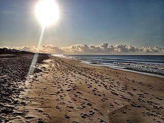
Oak Island is a seaside town located in the southeastern corner of North Carolina, United States. Part of Brunswick County, the major portion of the town is on Oak Island which it shares with Caswell Beach. Founded in 1999 as the result of the consolidation of two existing towns, Oak Island's main industry is tourism. Per the 2020 census, the Town has a permanent population of 8,396 while its average summer population ranges from 30 to 50,000. It along with the town of Caswell Beach is considered to be a part of the Myrtle Beach metropolitan area.

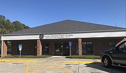
Southport is a city in Brunswick County, North Carolina, United States, near the mouth of the Cape Fear River. Its population was 3,828 as of the 2018 census. The mayor is Joseph P. Hatem.

Formby is a town and civil parish in the Metropolitan Borough of Sefton, Merseyside, England, which had a population of 57,098 at the 2023 Census.

Fire Island is the large center island of the outer barrier islands parallel to the South Shore of Long Island, in the U.S. state of New York.

Grand Bay-Westfield is a town on the west bank of the Saint John River immediately north of the boundary between Kings County and Saint John County of New Brunswick, Canada.

North Carolina Highway 211 (NC 211) is a 162.5-mile-long (261.5 km) primary state highway in the U.S. state of North Carolina. It traverses mostly through the Sandhills and Coastal Plain regions of the state; connecting the cities of Candor, Aberdeen, Raeford, Lumberton, Bladenboro, and Southport.

Ocean Shores is a coastal town in the Northern Rivers region of New South Wales, Australia with Billinudgel to the north and South Golden Beach and New Brighton to the east of the town. Established in 1977, Ocean Shores was originally a land holding owned by Wendell West of Washington with backing from American singer Pat Boone, and was named after Boone's residence in Ocean Shores, Washington. It is located in the Brunswick Valley – a valley including the towns of Mullumbimby and Brunswick Heads. The town has a local shopping complex and a large golf course. At the 2016 census, Ocean Shores had a population of 5,137 people.

North Carolina Highway 130 (NC 130) is a primary state highway in the U.S. state of North Carolina. The highway serves the towns and rural communities in southern Robeson County, acts as a direct route between Whiteville and Shallotte through the Green Swamp, and provides access to Holden Beach.

Cape Fear is a coastal plain and Tidewater region of North Carolina centered about the city of Wilmington. The region takes its name from the adjacent Cape Fear headland, as does the Cape Fear River which flows through the region and empties into the Atlantic Ocean near the cape. Much of the region's populated areas are found along the Atlantic beaches and the Atlantic Intracoastal Waterway, while the rural areas are dominated by farms and swampland like that of the Green Swamp. The general area can be also identified by the titles "Lower Cape Fear", "Wilmington Metropolitan Area", "Southeastern North Carolina", and "Azalea Coast". The latter name is derived from the North Carolina Azalea Festival held annually in Wilmington. Municipalities in the area belong to the Cape Fear Council of Governments.
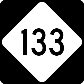
North Carolina Highway 133 (NC 133) is a primary state highway in the U.S. state of North Carolina. It traverses 46.6 miles (75.0 km) from Oak Island Drive in Oak Island to NC 210 in Bells Crossroads. The route serves communities such as Southport, Belville, Leland, Wilmington, and Castle Hayne. Additionally, NC 133 serves as an entry point for Military Ocean Terminal Sunny Point located to its east. Much of NC 133 runs parallel to the Cape Fear River and Brunswick River between Southport and Belville. West of Wilmington, NC 133 runs concurrently with U.S. Route 17 (US 17), US 74, and US 76. The road follows another concurrency along US 74 and US 421, west of Downtown Wilmington, and crosses into New Hanover County on the Isabel Holmes Bridge. North of Wilmington, NC 133 exits to the north, serving several suburban communities north of Wilmington. NC 133 runs concurrently with US 117 through Castle Hayne, before bearing northwest toward Bells Crossroads.

North Carolina Highway 906 (NC 906) is a primary state highway in the U.S. state of North Carolina. It serves as an access and evacuation route for Oak Island.