
The 2005 Atlantic hurricane season was the most active year on record until surpassed by 2020. It featured 28 tropical or subtropical storms. The United States National Hurricane Center named 27 storms, exhausting the annual pre-designated list, requiring the use of six Greek letter names, and adding an additional unnamed storm during a post-season re-analysis. A record 15 storms attained hurricane status, with maximum sustained winds of at least 74 miles per hour (119 km/h). Of those, a record seven became major hurricanes, rated Category 3 or higher on the Saffir–Simpson scale. Four storms of this season became Category 5 hurricanes, the highest ranking.

Hurricane Adrian was an early season hurricane which took an unusual southwest to northeast track, bringing it closer to El Salvador than any other hurricane since reliable records began in 1949. The first storm of the 2005 Pacific hurricane season, Adrian developed on May 17, just two days after the official start of the season, several hundred miles south-southeast of Mexico. Tracking in an atypical northwestward direction, the storm gradually intensified. On May 19, the storm reached its peak strength as a minimal hurricane with winds of 80 mph (130 km/h). Not long after reaching this intensity, the storm abruptly weakened. By the morning of May 20, the system had weakened to a minimal tropical storm and turned due west. Later that day, the storm made landfall along the Gulf of Fonseca in Honduras before dissipating several hours later.

The 2007 Atlantic hurricane season was the first season since 2003 to feature tropical activity both before and after the official bounds of the season. There were an above-average number of named storms during the season – 15, however many storms were weak and short-lived. Despite the predominance of weak systems, this was the first season on record to feature more than one Category 5 landfalling hurricane. This would not happen again until 2017. It produced 17 tropical cyclones, 15 tropical storms, six hurricanes, and two major hurricanes. It officially started on June 1 and ended on November 30, dates which conventionally delimit the period during which most tropical cyclones form in the Atlantic Ocean, although as shown by Subtropical Storm Andrea and Tropical Storm Olga in early May and early December, respectively, the formation of tropical cyclones is possible at any time of the year. The first system, Subtropical Storm Andrea, developed on May 9, while the last storm, Tropical Storm Olga, dissipated on December 13. The most intense hurricane, Dean, was, at the time, the third most intense landfalling Atlantic storm on record. It was the second on record in which an Atlantic hurricane, Felix, and an eastern Pacific hurricane, Henriette, made landfall on the same day. September had a then record-tying eight storms, until it was surpassed in 2020. However, the strengths and durations of most of the storms were low.

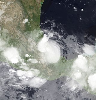
Hurricane Stan was the deadliest tropical cyclone of the 2005 Atlantic hurricane season. A relatively weak system that affected areas of Central America and Mexico in early October 2005, Stan was the eighteenth named storm and eleventh hurricane of the 2005 season, having formed from a tropical wave on October 1 after it had moved into the western Caribbean. The depression slowly intensified, and reached tropical storm intensity the following day, before subsequently making its first landfall on the Yucatán Peninsula. While traversing the peninsula, the tropical storm weakened, but was able to re-intensify once it entered the Bay of Campeche. Under favorable conditions for tropical development, Stan attained hurricane strength on October 4, and later reached peak intensity with winds of 80 mph (130 km/h) and a minimum barometric pressure of 977 mbar (28.9 inHg). The hurricane maintained this intensity until landfall near Punta Roca Partida, Mexico later the same day. Once over the mountainous terrain of Mexico, however, Stan quickly weakened, and dissipated on October 5.

Tropical Storm Tammy was a short-lived tropical storm during October in the 2005 Atlantic hurricane season which caused minor damage to the southeastern United States. More significant, however, were its remnants, which contributed to the Northeast U.S. flooding of October 2005.

Tropical Storm Alpha was the 23rd tropical or subtropical storm of the extremely active 2005 Atlantic hurricane season. It developed from Tropical Depression Twenty-Five in the eastern Caribbean Sea on October 22, 2005. As the 21 pre-designated storm names had been exhausted, it was given the first name on the auxiliary list, which utilized the letters of the Greek alphabet. This was the first hurricane season ever to trigger this naming protocol, and the only one until the 2020 season.

Tropical Storm Gamma was the 25th storm of the 2005 Atlantic hurricane season. Gamma formed on November 18 from a tropical wave which had left the coast of Africa on November 3. Between November 13 and November 16 the system was designated Tropical Depression Twenty-Seven and moved westward through the Windward Islands into the Caribbean. Although its winds were not of tropical storm force, the storm brought damagingly heavy rainfall to Trinidad and to St. Vincent and the Grenadines.

Tropical Storm Zeta was a very late-developing tropical storm that formed in the central Atlantic Ocean during the 2005 Atlantic hurricane season, one month after the season's official end. Becoming a tropical depression on December 30, and intensifying the following day into the season's 28th storm, Zeta continued into January 2006. It was one of only two Atlantic tropical cyclones to span two calendar years.
Tropical Storm Jose was a short-lived tropical storm which made landfall in central Mexico during August 2005. Jose was the tenth named storm of the 2005 Atlantic hurricane season and the fourth of six tropical cyclones to make landfall in Mexico in that year.
The 2005 Azores subtropical storm was the 19th nameable storm and only subtropical storm of the extremely active 2005 Atlantic hurricane season. It was not named by the National Hurricane Center as it was operationally classified as an extratropical low. It developed in the eastern Atlantic Ocean, an unusual region for late-season tropical cyclogenesis. Nonetheless, the system was able to generate a well-defined centre convecting around a warm core on 4 October. The system was short-lived, crossing over the Azores later on 4 October before becoming extratropical again on 5 October. No damages or fatalities were reported during that time. Its remnants were soon absorbed into a cold front. That system went on to become Hurricane Vince, which affected the Iberian Peninsula.

The 2008 Pacific hurricane season was a near-average Pacific hurricane season which featured seventeen named storms, though most were rather weak and short-lived. Only seven hurricanes formed and two major hurricanes. This season was also the first since 1996 to have no cyclones cross into the central Pacific. The season officially began on May 15 in the eastern Pacific and on June 1 in the central Pacific. It ended in both regions on November 30. These dates, adopted by convention, historically describe the period in each year when most tropical cyclone formation occurs in these regions of the Pacific. This season, the first system, Tropical Storm Alma, formed on May 29, and the last, Tropical Storm Polo, dissipated on November 5.

Tropical Storm Gabrielle was a short-lived tropical cyclone that passed over North Carolina before tracking out to sea. The seventh named storm of the 2007 Atlantic hurricane season, Gabrielle developed as a subtropical cyclone on September 8 about 385 miles (620 km) southeast of Cape Lookout, North Carolina. Unfavorable wind shear impacted the storm for much of its duration, although a temporary decrease in the shear allowed the cyclone to become a tropical storm. On September 9, Gabrielle made landfall at Cape Lookout National Seashore in the Outer Banks of North Carolina with winds of 60 mph (97 km/h). Turning to the northeast, the storm quickly weakened and dissipated on September 11.

The 2011 Pacific hurricane season was a below average season in terms of named storms, although it had an above average number of hurricanes and major hurricanes. During the season, 13 tropical depressions formed along with 11 tropical storms, 10 hurricanes and 6 major hurricanes. The season officially began on May 15 in the East Pacific Ocean, and on June 1 in the Central Pacific; they both ended on November 30. These dates conventionally delimit the period of each year when most tropical cyclones form in the Pacific basin. The season's first cyclone, Hurricane Adrian formed on June 7, and the last, Hurricane Kenneth, dissipated on November 25.

Tropical Storm Fay was a strong and unusual tropical storm that moved erratically across the state of Florida and the Caribbean Sea. The sixth named storm of the 2008 Atlantic hurricane season, Fay formed from a vigorous tropical wave on August 15 over the Dominican Republic. It passed over the island of Hispaniola, into the Gulf of Gonâve, across the island of Cuba, and made landfall on the Florida Keys late in the afternoon of August 18 before veering into the Gulf of Mexico. It again made landfall near Naples, Florida, in the early hours of August 19 and progressed northeast through the Florida peninsula, emerging into the Atlantic Ocean near Melbourne on August 20. Extensive flooding took place in parts of Florida as a result of its slow movement. On August 21, it made landfall again near New Smyrna Beach, Florida, moving due west across the Panhandle, crossing Gainesville and Panama City, Florida. As it zigzagged from water to land, it became the first storm in recorded history to make landfall in Florida four times. Thirty-six deaths were blamed on Fay. The storm also resulted in one of the most prolific tropical cyclone related tornado outbreaks on record. A total of 81 tornadoes touched down across five states, three of which were rated as EF2. Damage from Fay was heavy, estimated at $560 million.

Tropical Depression Five-E was a tropical depression which made landfall along the south-western Mexican coastline in July 2008. It was the fifth tropical cyclone of the 2008 Pacific hurricane season. The depression developed out of a weak tropical wave which formed off the coast of Africa on June 23. The wave remained poorly organized throughout its journey through the Atlantic Ocean and Caribbean Sea. The wave entered the Eastern Pacific on July 2 after passing through Central America. The wave developed into an area of low pressure that afternoon.

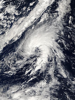
Hurricane Epsilon was the twenty-seventh named tropical or subtropical storm and the final of 15 hurricanes in the record-breaking 2005 Atlantic hurricane season. Originating from a cold front beneath an upper-level low, Epsilon formed on November 29 about 915 mi (1470 km) east of Bermuda, becoming the second tropical storm to do so in that area of the Atlantic within the span of a week. Initially, the National Hurricane Center (NHC) forecast the storm to transition into an extratropical cyclone within five days, due to conditions unfavorable for significant intensification. Epsilon continually defied forecasts, at first due to an unexpected loop to the southwest, and later due to retaining its strength despite cold waters and strong wind shear.

Subtropical Storm Alpha was the first subtropical or tropical cyclone ever observed to make landfall in mainland Portugal. The twenty-second tropical or subtropical cyclone and twenty-first named storm of the extremely active and record-breaking 2020 Atlantic hurricane season, Alpha originated from a large non-tropical low that was first monitored by the National Hurricane Center on 15 September. Initially not anticipated to transition into a tropical cyclone, the low gradually tracked south-southeastward for several days with little development. By early on 17 September, the low had separated from its frontal features and exhibited sufficient organization to be classified as a subtropical cyclone, as it approached the Iberian Peninsula, becoming a subtropical storm around that time. Alpha then made landfall just south of Figueira da Foz, Portugal during the evening of 18 September, then rapidly weakened as it moved over the mountainous terrain of Northeastern Portugal. The system degenerated into a remnant low on 19 September, when it was last noted.

Hurricane Gamma was a Category 1 hurricane that brought heavy rains, flooding, and landslides to the Yucatán Peninsula in early October 2020. The twenty-fifth depression, twenty-fourth named storm and ninth hurricane of the extremely active 2020 Atlantic hurricane season, Gamma developed from a vigorous tropical wave that had been monitored as it was entering the Eastern Caribbean on September 29. The wave moved westward and slowed down as it moved into the Western Caribbean, where it began to interact with a dissipating cold front. A low formed within the disturbance on October 1 and the next day, it organized into a tropical depression. It further organized into Tropical Storm Gamma early the next day. It continued to intensify and made landfall as a minimal hurricane near Tulum, Mexico, on October 3. It weakened over land before reemerging in the Gulf of Mexico. Gamma then briefly restrengthened some before being blasted by high amounts of wind shear, causing it to weaken again. It made a second landfall as a tropical depression in Nichili, Mexico on October 6 before dissipating as it was absorbed by the approaching Hurricane Delta.


