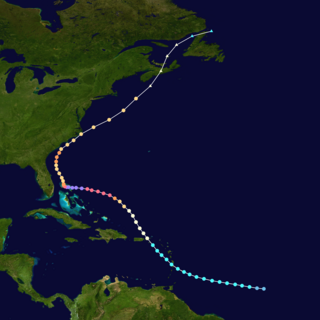
The 1967 Atlantic hurricane season was the first Atlantic hurricane season to be part of the modern-day satellite era. With 13 named storms, it was an above average season in terms of named storms, slightly above average in terms of hurricanes (6), and below average in terms of major hurricanes, with only one; Beulah. The season began on June 1, 1967, and ended on November 30, 1967, which delimits the time boundaries when tropical cyclones in the North Atlantic Ocean typically form. The first depression originated on June 10, and the final storm – Heidi – lost tropical characteristics on October 31.

Hurricane Gordon was the first tropical cyclone since 1992 to affect the Azores while retaining tropical characteristics. The eighth tropical storm, third hurricane, and first major hurricane of the 2006 Atlantic hurricane season, Gordon formed on September 10 in the tropical Atlantic Ocean. It gradually matured into a hurricane as it tracked northward, reaching its peak intensity with winds of 195 km/h (121 mph) early on September 14 while located about 925 km (575 mi) southeast of Bermuda. After becoming nearly stationary, Gordon weakened to minimal hurricane status, although it re-intensified after accelerating to the east. It weakened again after moving over cooler waters, and passed through the Azores on September 20. Shortly thereafter, it became an extratropical cyclone and subsequently affected Spain, Ireland, and the United Kingdom.
The 2005 Azores subtropical storm was the 19th nameable storm and only subtropical storm of the extremely active 2005 Atlantic hurricane season. It was not named by the National Hurricane Center as it was operationally classified as an extratropical low. It developed in the eastern Atlantic Ocean, an unusual region for late-season tropical cyclogenesis. Nonetheless, the system was able to generate a well-defined centre convecting around a warm core on 4 October. The system was short-lived, crossing over the Azores later on 4 October before becoming extratropical again on 5 October. No damages or fatalities were reported during that time. Its remnants were soon absorbed into a cold front. That system went on to become Hurricane Vince, which affected the Iberian Peninsula.

Tropical Storm Laura was a large but short-lived tropical cyclone that developed over the north-central Atlantic Ocean in late September during the 2008 Atlantic hurricane season. Laura's remnants later impacted the Netherlands, Germany, and Norway. The 12th named storm of the season, Laura formed out of a large extratropical area of low pressure located about 1,015 miles (1,633 km) west of the Azores on September 29. Laura slowly developed tropical characteristics throughout the day as it moved over warmer waters. On the afternoon of September 30, Laura had acquired enough tropical characteristics to be designated a tropical storm. Shortly after being declared tropical, Laura began to undergo an extratropical transition, which did not fully take place until the morning of October 1. Laura degenerated into a post-tropical cyclone later that morning, and the final advisory by the National Hurricane Center was issued. The remnants of Laura contributed to heavy rainfall and power outages in the British Isles, the Netherlands, and Norway on October 5 to 8.

The 2001 Atlantic hurricane season was an above-average Atlantic hurricane season in which fifteen named storms formed. The season officially began on June 1 and ended on November 30, dates that conventionally delimit the period of each year when most tropical cyclones form in the Atlantic basin. The season's first tropical cyclone, Tropical Storm Allison, formed on June 5 while the season's final system, Hurricane Olga, dissipated on December 6.

Tropical Storm Grace holds the record for being the farthest northeast forming tropical cyclone in the Atlantic basin. The seventh named storm of the slightly below average 2009 Atlantic hurricane season, Grace formed from an extratropical cyclone over the Azores on 4 October. It strengthened to attain peak sustained winds of 65 mph (100 km/h) and developed an eye-like feature, although cold sea surface temperatures inhibited the development of thunderstorm activity near the center. The storm lost its tropical characteristics on 6 October, and the storm's remnants merged with a separate system near the British Isles on 7 October.

Hurricane Epsilon was the twenty-seventh named tropical or subtropical storm and the final of 15 hurricanes in the record-breaking 2005 Atlantic hurricane season. Originating from a cold front beneath an upper-level low, Epsilon formed on November 29 about 915 mi (1470 km) east of Bermuda, becoming the second tropical storm to do so in that area of the Atlantic within the span of a week. Initially, the National Hurricane Center (NHC) forecast the storm to transition into an extratropical cyclone within five days, due to conditions unfavorable for significant intensification. Epsilon continually defied forecasts, at first due to an unexpected loop to the southwest, and later due to retaining its strength despite cold waters and strong wind shear.

The 2012 Atlantic hurricane season was an event in the annual hurricane season in the north Atlantic Ocean. For the third year in a row there were 19 named storms. The season officially began on June 1, 2012, and ended on November 30, 2012, dates that conventionally delimit the period of each year when most tropical cyclones develop in the Atlantic basin. Surprisingly, two preseason storms formed: Alberto on May 19, and Beryl on May 26. This was the first such occurrence since the 1951 season. The final storm to dissipate was Sandy, on October 29. Altogether, ten storms became hurricanes, of which two intensified into major hurricanes.

The 2016 Atlantic hurricane season was the deadliest Atlantic hurricane season since 2008, and the first above-average hurricane season since 2012, producing 15 named storms, 7 hurricanes and 4 major hurricanes. The season officially started on June 1 and ended on November 30, though the first storm, Hurricane Alex which formed in the Northeastern Atlantic, developed on January 12, being the first hurricane to develop in January since 1938. The final storm, Otto, crossed into the Eastern Pacific on November 25, a few days before the official end. Following Alex, Tropical Storm Bonnie brought flooding to South Carolina and portions of North Carolina. Tropical Storm Colin in early June brought minor flooding and wind damage to parts of the Southeastern United States, especially Florida. Hurricane Earl left 94 fatalities in the Dominican Republic and Mexico, 81 of which occurred in the latter. In early September, Hurricane Hermine, the first hurricane to make landfall in Florida since Hurricane Wilma in 2005, brought extensive coastal flooding damage especially to the Forgotten and Nature coasts of Florida. Hermine was responsible for five fatalities and about $550 million (2016 USD) in damage.

The 2018 Atlantic hurricane season was the third in a consecutive series of above-average and damaging Atlantic hurricane seasons, featuring 15 named storms, 8 hurricanes, and 2 major hurricanes, which caused a total of over $50 billion in damages and at least 172 deaths. More than 98% of the total damage was caused by two hurricanes. The season officially began on June 1, 2018, and ended on November 30, 2018. These dates historically describe the period in each year when most tropical cyclones form in the Atlantic basin and are adopted by convention. However, subtropical or tropical cyclogenesis is possible at any time of the year, as demonstrated by the formation of Tropical Storm Alberto on May 25, making this the fourth consecutive year in which a storm developed before the official start of the season. The season concluded with Oscar transitioning into an extratropical cyclone on October 31, almost a month before the official end.

The 2019 Atlantic hurricane season was the fourth consecutive above-average and damaging season dating back to 2016. However, many storms were weak and short-lived, especially towards the end of the season. Six of those named storms achieved hurricane status, while three intensified into major hurricanes. Two storms became Category 5 hurricanes, marking the fourth consecutive season with at least one Category 5 hurricane, the third consecutive season to feature at least one storm making landfall at Category 5 intensity, and the seventh on record to have multiple tropical cyclones reaching Category 5 strength. The season officially began on June 1 and ended on November 30. These dates historically describe the period each year when most tropical cyclones form in the Atlantic basin and are adopted by convention. However, tropical cyclogenesis is possible at any time of the year, as demonstrated by the formation of Subtropical Storm Andrea on May 20, making this the fifth consecutive year in which a tropical or subtropical cyclone developed outside of the official season.

The 2020 Atlantic hurricane season was the most active Atlantic hurricane season on record, in terms of number of systems. It featured a total of 31 tropical or subtropical cyclones, with all but one cyclone becoming a named storm. Of the 30 named storms, 14 developed into hurricanes, and a record-tying seven further intensified into major hurricanes. It was the second and final season to use the Greek letter storm naming system, the first being 2005, the previous record. Of the 30 named storms, 11 of them made landfall in the contiguous United States, breaking the record of nine set in 1916. During the season, 27 tropical storms established a new record for earliest formation date by storm number. This season also featured a record ten tropical cyclones that underwent rapid intensification, tying it with 1995, as well as tying the record for most Category 4 hurricanes in a singular season in the Atlantic Basin. This unprecedented activity was fueled by a La Niña that developed in the summer months of 2020, continuing a stretch of above-average seasonal activity that began in 2016. Despite the record-high activity, this was the first season since 2015 in which no Category 5 hurricanes formed.

The 2013 Atlantic hurricane season was an event in the annual hurricane season in the north Atlantic Ocean. It featured below-average tropical cyclone activity, with the fewest hurricanes since the 1982 season. The season officially began on June 1, 2013 and ended on November 30, 2013. These dates, adopted by convention, historically delimit the period in each year when most tropical systems form. The season's first storm, Tropical Storm Andrea formed on June 5, and its final storm, an unnamed subtropical storm, dissipated on December 7. Altogether, there were 13 named tropical storms during the season. Two of which attained hurricane strength, but neither intensified into a major hurricane, the first such occurrence since the 1994 season.

Hurricane Alex was the first Atlantic hurricane to occur in January since Hurricane Alice of 1954–55. Alex originated as a non-tropical low near the Bahamas on January 7, 2016. Initially traveling northeast, the system passed by Bermuda on January 8 before turning southeast and deepening. It briefly acquired hurricane-force winds by January 10, then weakened slightly before curving towards the east and later northeast. Acquiring more tropical weather characteristics over time, the system transitioned into a subtropical cyclone well south of the Azores on January 12, becoming the first North Atlantic tropical or subtropical cyclone in January since Tropical Storm Zeta of 2005–2006. Alex continued to develop tropical features while turning north-northeast, and transitioned into a fully tropical cyclone on January 14. The cyclone peaked in strength as a Category 1 hurricane on the Saffir–Simpson scale (SSHWS), with maximum sustained winds of 85 mph and a central pressure of 981 mbar. Alex weakened to a high-end tropical storm before making landfall on Terceira Island on January 15. By that time, the storm was losing its tropical characteristics; it fully transitioned back into a non-tropical cyclone several hours after moving away from the Azores. Alex ultimately merged with another cyclone over the Labrador Sea on January 17.

Hurricane Ophelia was regarded as the worst storm to affect Ireland in 50 years, and was also the easternmost Atlantic major hurricane on record. The tenth and final consecutive hurricane and the sixth major hurricane of the very active 2017 Atlantic hurricane season, Ophelia had non-tropical origins from a decaying cold front on 6 October. Located within a favorable environment, the storm steadily strengthened over the next two days, drifting north and then southeastwards before becoming a hurricane on 11 October. After becoming a Category 2 hurricane and fluctuating in intensity for a day, Ophelia intensified into a major hurricane on 14 October south of the Azores, brushing the archipelago with high winds and heavy rainfall. Shortly after achieving peak intensity, Ophelia began weakening as it accelerated over progressively colder waters to its northeast towards Ireland and Great Britain. Completing an extratropical transition early on 16 October, Ophelia became the second storm of the 2017–18 European windstorm season. Early on 17 October, the cyclone crossed the North Sea and struck western Norway, with wind gusts up to 70 kilometres per hour (43 mph) in Rogaland county, before weakening during the evening of 17 October. The system then moved across Scandinavia, before dissipating over Norway on the next day.
The 2021 Atlantic hurricane season was the third-most active Atlantic hurricane season on record in terms of number of tropical cyclones, although many of them were weak and short-lived. With 21 named storms forming, it became the second season in a row and third overall in which the designated 21-name list of storm names was exhausted. Seven of those storms strengthened into a hurricane, four of which reached major hurricane intensity, which is slightly above-average. The season officially began on June 1 and ended on November 30. These dates historically describe the period in each year when most Atlantic tropical cyclones form. However, subtropical or tropical cyclogenesis is possible at any time of the year, as demonstrated by the development of Tropical Storm Ana on May 22, making this the seventh consecutive year in which a storm developed outside of the official season.
The 2019 Atlantic hurricane season was an event in the annual tropical cyclone season in the north Atlantic Ocean. It was the fourth consecutive above-normal Atlantic hurricane season. The season officially began on June 1, 2019 and ended on November 30, 2019. These dates, adopted by convention, historically describe the period in each year when most tropical systems form. However, storm formation is possible at any time of the year, as demonstrated in 2019 by the formation of the season's first named storm, Subtropical Storm Andrea, on May 20. The final storm of the season, Tropical Storm Sebastien, transitioned to an extratropical cyclone on November 25.
Hurricane Dorian was the strongest hurricane to affect The Bahamas on record, causing catastrophic damage on the islands of Abaco Islands and Grand Bahama, in early September 2019. The cyclone's intensity, as well as its slow forward motion near The Bahamas, broke numerous records. The fifth tropical cyclone, fourth named storm, second hurricane, and first major hurricane of the 2019 Atlantic hurricane season, Dorian originated from a westward-traveling tropical wave, that departed from the western coast of Africa on August 19. The system organized into a tropical depression and later a tropical storm, both on August 24.

Hurricane Paulette was a strong and long-lived Category 2 Atlantic hurricane which became the first to make landfall in Bermuda since Hurricane Gonzalo did so in 2014. The sixteenth named storm and sixth hurricane of the record-breaking 2020 Atlantic hurricane season, Paulette developed from a tropical wave that left the coast of Africa on September 2. The wave eventually consolidated into a tropical depression on September 7. Paulette fluctuated in intensity over the next few days, due to strong wind shear, initially peaking as a strong tropical storm on September 8. It eventually strengthened into a hurricane early on September 13 as shear decreased. On September 14, Paulette made landfall in northeastern Bermuda as a Category 2 hurricane, while making a gradual turn to the northeast. The cyclone further strengthened as it moved away from the island, reaching its peak intensity with 1-minute sustained winds of 105 mph (169 km/h) and a minimum central atmospheric pressure of 965 mbar (28.5 inHg) on September 14. On the evening of September 15, Paulette began to weaken and undergo extratropical transition, which it completed on September 16. The hurricane's extratropical remnants persisted and moved southward then eastward, and eventually, Paulette regenerated into a tropical storm early on September 20 south of the Azores– which resulted in the U.S National Weather Service coining the phrase "zombie storm" to describe its unusual regeneration. Paulette's second phase proved short-lived, however, as the storm quickly weakened and became post-tropical again two days later. The remnant persisted for several days before dissipating south of the Azores on September 28. In total, Paulette was a tropical cyclone for 11.25 days, and the system had an overall lifespan of 21 days.

 The precursor disturbance on October 23, 2019, while fully extratropical [3]
 The low begins to gain subtropical characteristics on October 24, with convection increasing over a well-defined low-level circulation center [3]
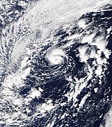
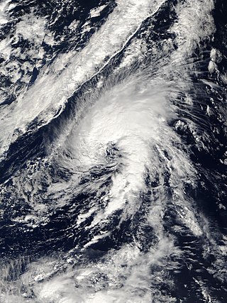
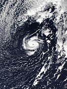 Banding features become increasingly defined, and an eye appears, signifying the storm's transition into a fully tropical storm. [1]
 Pablo forms a clear eye with deep convection surrounding it on October 27, marking its intensification into a hurricane. [1]


