
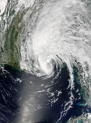
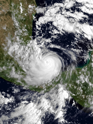
Hurricane Roxanne was a rare and erratic tropical cyclone that caused extensive flooding in Mexico due to its unusual movement. The seventeenth storm, tenth hurricane, and the fifth and final major hurricane of the very active 1995 Atlantic hurricane season, Roxanne developed in the southwestern Caribbean Sea from an area of low pressure on October 7. The depression curved northward, causing it to avoid landfall in Central America. By October 9, the depression intensified enough to be upgraded to Tropical Storm Roxanne. On the following day, Roxanne turned west-northward, where it promptly intensified into a hurricane. As Roxanne headed generally westward, it began to rapidly deepen and reached Category 3 intensity less than 24 hours after becoming a hurricane. Shortly thereafter, Roxanne made landfall near Cozumel, Mexico at its peak intensity, which caused severe damage.

The 1989 Pacific hurricane season was the first near normal season since 1981. The season officially started on May 15, 1989, in the eastern Pacific, and June 1, 1989, in the central Pacific, and lasted until November 30, 1989. These dates conventionally delimit the period of each year when most tropical cyclones form in the northeastern Pacific Ocean. A total of 18 storms and 9 hurricanes formed, which was near long-term averages. Four hurricanes reached major hurricane status on the Saffir–Simpson scale.

The 2007 Atlantic hurricane season was the first season since 2003 to feature tropical activity both before and after the official bounds of the season. There were an above-average number of named storms during the season – 15, however many storms were weak and short-lived. Despite the predominance of weak systems, this was the first season on record to feature more than one Category 5 landfalling hurricane. This would not happen again until 2017. It produced 17 tropical cyclones, 15 tropical storms, six hurricanes, and two major hurricanes. It officially started on June 1 and ended on November 30, dates which conventionally delimit the period during which most tropical cyclones form in the Atlantic Ocean, although as shown by Subtropical Storm Andrea and Tropical Storm Olga in early May and early December, respectively, the formation of tropical cyclones is possible at any time of the year. The first system, Subtropical Storm Andrea, developed on May 9, while the last storm, Tropical Storm Olga, dissipated on December 13. The most intense hurricane, Dean, was, at the time, the third most intense landfalling Atlantic storm on record. It was the second on record in which an Atlantic hurricane, Felix, and an eastern Pacific hurricane, Henriette, made landfall on the same day. September had a then record-tying eight storms, until it was surpassed in 2020. However, the strengths and durations of most of the storms were low.

Hurricane Stan was the deadliest tropical cyclone of the 2005 Atlantic hurricane season. A relatively weak system that affected areas of Central America and Mexico in early October 2005, Stan was the eighteenth named storm and eleventh hurricane of the 2005 season, having formed from a tropical wave on October 1 after it had moved into the western Caribbean. The depression slowly intensified, and reached tropical storm intensity the following day, before subsequently making its first landfall on the Yucatán Peninsula. While traversing the peninsula, the tropical storm weakened, but was able to re-intensify once it entered the Bay of Campeche. Under favorable conditions for tropical development, Stan attained hurricane strength on October 4, and later reached peak intensity with winds of 80 mph (130 km/h) and a minimum barometric pressure of 977 mbar (28.9 inHg). The hurricane maintained this intensity until landfall near Punta Roca Partida, Mexico later the same day. Once over the mountainous terrain of Mexico, however, Stan quickly weakened, and dissipated on October 5.

Hurricane Bret was the first of five Category 4 hurricanes that developed during the 1999 Atlantic hurricane season and the first tropical cyclone since Hurricane Jerry in 1989 to make landfall in Texas at hurricane intensity. Forming from a tropical wave on August 18, Bret slowly organized within weak steering currents in the Bay of Campeche. By August 20, the storm began to track northward and underwent rapid intensification on August 21. After this period of strengthening, Bret attained its peak intensity with winds of 145 miles per hour (233 km/h) and a barometric pressure of 944 mbar (hPa; 27.9 inHg). Later that day, the storm weakened to a Category 3 hurricane and made landfall on Padre Island, Texas. Shortly thereafter, the storm weakened further, becoming a tropical depression 24 hours after moving inland. The remnants of the storm eventually dissipated early on August 26 over northern Mexico.
Tropical Storm Arlene was an unusually large and early-forming tropical storm, being the first of twenty-eight different storms during the 2005 Atlantic hurricane season, which would become the second most active season on record. Tropical Storm Arlene formed near Honduras on June 8 and moved northwards. It crossed western Cuba on June 10 and strengthened to just under hurricane strength before making its final landfall on the Florida Panhandle the next day. The storm weakened as it continued to move north over the United States, becoming extratropical on June 13. Arlene was responsible for two deaths and minor damage.

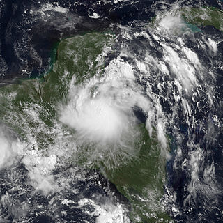
Tropical Storm Bret was a short-lived tropical storm in June 2005 that had damaging effects in Veracruz, Mexico. The second named storm of the season, Bret quickly developed from a tropical wave on June 28 in the Bay of Campeche. Failing to intensify beyond minimal tropical storm intensity, the system made landfall in Veracruz the following day. It rapidly weakened once onshore, dissipating early on June 30. The storm brought heavy rainfall to Veracruz, San Luis Potosí, and Tamaulipas with the former suffering the brunt of the impacts. Approximately 11,000 people were adversely affected by widespread flooding. A total of 2,129 homes were damaged and 25 were destroyed, mostly in the city of Naranjos. Three people were killed in storm-related incidents and total losses exceeded 100 million pesos (US$9.3 million). The Government of Veracruz declared emergencies for nine municipalities and released tens of millions of pesos in relief aid in conjunction with national agencies.
Tropical Storm Chantal was a North Atlantic tropical cyclone that moved across the Caribbean Sea in August 2001. The fourth depression and third named storm of the 2001 Atlantic hurricane season, Chantal developed from a tropical wave on August 14 in the tropical Atlantic Ocean. It tracked rapidly westward for much of its duration, and after degenerating into a tropical wave, it passed through the Windward Islands. Chantal reached a peak intensity of 70 mph (110 km/h) twice in the Caribbean Sea, and each time it was anticipated to attain hurricane status; however, wind shear and later land interaction prevented strengthening to hurricane status. On August 21 Chantal, moved ashore near the border of Mexico and Belize, before dissipating on the next day.
Tropical Storm Bertha was a minimal tropical storm that made landfall twice along the Gulf Coast of the United States in August 2002. The second tropical storm of the 2002 Atlantic hurricane season, Bertha developed in the northern Gulf of Mexico out of a trough of low pressure that extended into the Atlantic on August 4. It quickly organized and reached tropical storm strength before making landfall on southeastern Louisiana. Bertha turned to the southwest over the state, and re-entered the Gulf of Mexico on August 7. It remained disorganized due to proximity to land, and after making landfall on south Texas, Bertha dissipated on August 9.
Tropical Storm Julio was a tropical storm that made landfall on the southern tip of Baja California Sur in August 2008. The tenth named storm of the 2008 Pacific hurricane season, it developed from a tropical wave on August 23 off the coast of Mexico. It moved parallel to the coast, reaching peak winds of 50 mph (85 km/h) before moving ashore and weakening. On August 26 it dissipated in the Gulf of California. Julio was the third tropical cyclone to make landfall in the Pacific Ocean basin during the season, after Tropical Storm Alma, which struck Nicaragua in May, and Tropical Depression Five-E, which moved ashore along southwestern Mexico in July. The storm brought locally heavy rainfall to southern Baja California, killing one person and leaving several towns isolated. Moisture from Julio reached Arizona, producing thunderstorms, including one which damaged ten small planes in Chandler.

Tropical Storm Carlos was the first of five tropical cyclones to make landfall during the 2003 Pacific hurricane season. It formed on June 26 from a tropical wave to the south of Mexico. It quickly strengthened as it approached the coast, and early on June 27 Carlos moved ashore in Oaxaca with winds of 65 mph (105 km/h). The storm rapidly deteriorated to a remnant low, which persisted until dissipating on June 29. Carlos brought heavy rainfall to portions of southern Mexico, peaking at 337 mm (13.3 in) in two locations in Guerrero. Throughout its path, the storm damaged about 30,000 houses, with a monetary damage total of 86.7 million pesos. At least nine people were killed throughout the country, seven due to mudslides and two from river flooding; there was also a report of two missing fishermen.
Hurricane Karl was the most destructive tropical cyclone on record to strike the Mexican state of Veracruz. The eleventh tropical storm, sixth hurricane, and fifth and final major hurricane of the 2010 Atlantic hurricane season, Karl formed from an area of low pressure which had formed off of the northern coast Venezuela on September 11. It crossed the Caribbean and was upgraded to Tropical Storm Karl on September 14. The cyclone made landfall on the Yucatan Peninsula of Mexico as a strong tropical storm, and then rapidly strengthened in the Bay of Campeche before it made landfall near the city of Veracruz, on the central Mexican Gulf coast, as a major hurricane. This marked the first known time that a major hurricane existed in the Bay of Campeche. Afterwards, the storm rapidly weakened over the mountains of Mexico and dissipated on September 18.

Tropical Storm Barry was a weak and short-lived tropical cyclone that brought heavy rains to parts of Central America and Mexico in June 2013. Barry originated from a tropical wave that developed in the southern Caribbean Sea. The wave tracked northwestward and began to develop in marginally favorable conditions. On June 17, the disturbance was upgraded to Tropical Depression Two by the National Hurricane Center. Due to its close proximity to land, the system failed to intensify before crossing the southern Yucatán Peninsula. The depression emerged over the Bay of Campeche late on June 18 and became increasingly organized. During the afternoon of June 19, data from Hurricane Hunters revealed the system had intensified into a tropical storm. The newly named Barry attained peak winds of 45 mph (75 km/h) before making landfall in Veracruz, Mexico on June 20. Once onshore, the storm quickly weakened and degenerated into a remnant low that night.

Hurricane Ingrid was one of two tropical cyclones, along with Hurricane Manuel, to strike Mexico within a 24-hour period, the first such occurrence since 1958. Ingrid was the ninth named storm and second hurricane of the 2013 Atlantic hurricane season. It formed on September 12 in the Gulf of Mexico from a broad disturbance that also spawned Manuel in the eastern Pacific. After initially moving westward toward Veracruz, Ingrid turned northeastward away from the coast. Favorable conditions allowed it to attain hurricane status on September 14, and the next day Ingrid attained peak winds of 140 km/h (85 mph). Subsequently, increased wind shear weakened the convection as the storm turned more to the northwest and west. On September 16, Ingrid made landfall just south of La Pesca, Tamaulipas in northeastern Mexico as a strong tropical storm, and dissipated the next day. The hurricane was also the last one to form in the Gulf of Mexico until Hurricane Hermine in 2016.

Tropical Storm Trudy was a short-lived tropical cyclone in October 2014 that caused significant flooding in southern Mexico. The storm originated from an area of low pressure associated with a monsoon trough near Central America in early October. A slow-moving system, the low eventually consolidated into a tropical depression on October 17 near the Mexican coastline. Favorable environmental conditions aided rapid development of Trudy. Within 15 hours of its designation, an eye formed over the storm's center. Trudy ultimately achieved its peak intensity as a strong tropical storm with 65 mph (100 km/h) winds as it made landfall just southeast of Marquelia, Mexico. The region's mountainous terrain quickly weakened Trudy and the cyclone dissipated early on October 19. Though the cyclone dissipated, its remnant energy later contributed to the formation of Tropical Storm Hanna in the Atlantic.
Tropical Storm Harvey was the final tropical cyclone in a record-breaking string of eight consecutive storms that failed to attain hurricane intensity. The eighth tropical cyclone and eighth named storm of the 2011 Atlantic hurricane season, Harvey developed from a tropical wave in the western Caribbean Sea on August 19. It moved over warm waters in the vicinity of Central America. Later on August 19, the system strengthened into Tropical Storm Harvey while just offshore Honduras. Additional organization occurred and Harvey attained its peak intensity of 65 mph (100 km/h) prior to coming ashore Belize on August 20. Harvey weakened to a tropical depression on August 21, but re-intensified to a tropical storm after emerging into the Bay of Campeche. Early on August 22, it made landfall in Veracruz, then weakened and dissipated several hours later.

Hurricane Franklin was the first hurricane to make landfall in the Mexican state of Veracruz since Hurricane Karl in 2010. The sixth named storm, first hurricane and the first of ten consecutive hurricanes of the 2017 Atlantic hurricane season, Franklin formed on August 7 out of a tropical wave that was first tracked in the southeastern Caribbean Sea on August 3. The storm strengthened within a favorable environment and made landfall on the Yucatán Peninsula as a moderate tropical storm early on August 8 north of Belize. Weakening occurred as it crossed the peninsula, but Franklin re-emerged into the Bay of Campeche later that day, restrengthening quickly to become the season's first hurricane. It made landfall near Lechuguillas, Veracruz, on August 10 as a Category 1 hurricane, before rapidly weakening over the mountainous terrain of Mexico and dissipating shortly afterwards. On August 12, the storm's remnant mid-level circulation combined with a developing low in the Eastern Pacific to form Tropical Storm Jova.

Hurricane Katia was a strong Atlantic hurricane which became the most intense storm to hit the Bay of Campeche since Karl in 2010. The eleventh named storm and sixth hurricane of the exceptionally active 2017 Atlantic hurricane season, Katia originated on September 5, out of a broad low-pressure area that formed in the Bay of Campeche. Located in an area of weak steering currents, Katia meandered around in the region, eventually intensifying into a hurricane on September 6. The nascent storm eventually peaked as a 105 mph (165 km/h) Category 2 hurricane on the Saffir–Simpson scale while it began to move southwestward. However, land interaction began to weaken the hurricane as it approached the Gulf Coast of Mexico. Early on September 9, Katia made landfall near Tecolutla at minimal hurricane intensity. The storm quickly dissipated several hours later, although its mid-level circulation remained intact and later spawned what would become Hurricane Otis in the Eastern Pacific.

Tropical Storm Helene was a moderate tropical storm which affected the southern Caribbean and Central America in mid-August 2012. The seventh tropical depression and eighth named storm of the 2012 Atlantic hurricane season, Helene was monitored as a tropical wave that exited the west coast of the African continent on August 5. It gradually moved westward and became a tropical depression east of the Lesser Antilles four days later. However, unfavorable conditions initially prevented it from developing, which led to its initial degeneration to a remnant low as it traversed the Caribbean Sea.

Hurricane Grace was the strongest tropical cyclone to make landfall in the Mexican state of Veracruz. Grace impacted much of the Leeward Islands and Greater Antilles as a tropical storm, before causing more substantial impacts in the Yucatán Peninsula and Veracruz as a hurricane. It was the seventh named storm, second hurricane, and first major hurricane of the 2021 Atlantic hurricane season. Originating from a tropical wave in the Main Development Region, the primitive system tracked west-northwest across the Atlantic Ocean towards the Antilles, becoming a tropical depression on August 14. It strengthened into Tropical Storm Grace later the same day, but weakened back to a depression due to an unfavorable environment. After moving near Haiti as a tropical depression, it strengthened back to a tropical storm and became a hurricane on August 18, reaching an initial peak intensity with maximum sustained winds of 80 mph (130 km/h) and a pressure of 986 mbar (29.12 inHg). It weakened back to a tropical storm after its landfall in the Yucatán Peninsula and emerged into the Bay of Campeche, entering a very favorable environment for intensification hours later. Grace then rapidly intensified into a Category 3 hurricane with winds of 120 mph (190 km/h) in about 24 hours. The storm made its final landfall in the state of Veracruz at peak intensity and quickly degenerated into a remnant low over mainland Mexico on August 21; however, its remnants later regenerated into Tropical Storm Marty in the Eastern Pacific on August 23.


