Lee County is located in southwestern Florida, United States, on the Gulf Coast. As of the 2020 census, its population was 760,822. In 2022, the population was 822,453, making it the eighth-most populous county in the state. The county seat is Fort Myers, with a population of 86,395 as of the 2020 census, and the largest city is Cape Coral, with an estimated 2020 population of 194,016.

Captiva is an unincorporated community and census-designated place (CDP) in Lee County, Florida, United States. It is located on Captiva Island. As of the 2020 census, the population was 318, down from 583 at the 2010 census. It is part of the Cape Coral-Fort Myers, Florida Metropolitan Statistical Area.

Sanibel is an island and city in Lee County, Florida, United States. The population was 6,382 at the 2020 census, down from 6,469 at the 2010 census. It is part of the Cape Coral-Fort Myers, Florida Metropolitan Statistical Area. The island, also known as Sanibel Island, constitutes the entire city. It is a barrier island—a collection of sand on the leeward side of the more solid coral-rock of Pine Island.

Hurricane Charley was the first of four separate hurricanes to impact or strike Florida during 2004, along with Frances, Ivan and Jeanne, as well as one of the strongest hurricanes ever to strike the United States. It was the third named storm, the second hurricane, and the second major hurricane of the 2004 Atlantic hurricane season. Charley lasted from August 9 to 15, and at its peak intensity it attained 150 mph (240 km/h) winds, making it a strong Category 4 hurricane on the Saffir–Simpson scale. It made landfall in Southwest Florida at maximum strength, making it the strongest hurricane to hit the United States since Hurricane Andrew struck Florida in 1992 and tied with Hurricane Ian as the strongest hurricane to hit southwest Florida in recorded history.
Pine Island is the largest island on the Gulf Coast of peninsular Florida in the United States. Located in Lee County, on the Gulf of Mexico coast of southwest Florida, it is also the 118th largest island in the United States. The Intracoastal Waterway passes through Pine Island Sound, to the west of the island. Matlacha Pass runs between Pine Island and the mainland. Pine Island lies west of Cape Coral. For many years, Pine Island was a major commercial fishing community and many of its full-time residents still fish commercially today.

Pine Island Sound is located in Lee County, Florida, lying between Pine Island and the barrier islands of Sanibel Island, Captiva Island, North Captiva Island and Cayo Costa, which separate the Sound from the Gulf of Mexico. The Sound connects to Gasparilla Sound and Charlotte Harbor to the north, and to San Carlos Bay and the Caloosahatchee River to the south. The Sound is conterminous with the Pine Island Sound Aquatic Preserve, which was established in 1970 and consists of 54,000 acres (220 km2) of submerged land. Important habitats in the Sound include mangroves, seagrasses, salt marshes, oyster communities, tidal flats and sponge beds. All animals in and around Pine Island sound, including mollusks, fish, birds and mammals, are affected by periodic outbreaks of red tide. The Sound is relatively shallow in many locations, and boaters are cautioned to utilize up-to-date charts and tide tables.

The Sanibel Causeway is a causeway in Southwest Florida that spans San Carlos Bay, connecting Sanibel Island with the Florida mainland in Punta Rassa. The causeway consists of three separate two-lane bridge spans, and two-man-made causeway islands between them. The entire causeway facility is owned by Lee County and operated by the Lee County Department of Transportation. The entire causeway is 3 miles (5 km) long from end to end, and currently has a $6 toll in effect for island-bound vehicles only. The bridges are not individually named, and are simply referred to as bridges A, B, and C. The islands are also named A and B. Both series begin from the mainland side.

Area code 239 is a telephone area code in the North American Numbering Plan (NANP) for a part of Southwestern Florida. The numbering plan area (NPA) includes Lee and Collier counties, small parts of Hendry and Charlotte counties and the Everglades National Park in Mainland Monroe County. The area code was activated for service on March 11, 2002, in an area code split in which the southern half of NPA 941, from North Fort Myers, was renumbered with 239. A permissive dialing period ended on March 10, 2003.

Cayo Costa State Park is a state park in the U.S. state of Florida, on Cayo Costa, an island directly south of Boca Grande and just north of North Captiva Island, approximately 12 miles (19 km) west of Cape Coral. The park is accessible only by charter boat, private boat, ferry or helicopter.
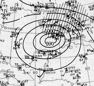
The Tampa Bay hurricane of 1921 was a destructive and deadly major hurricane which made landfall in the Tampa Bay area of Florida in late October 1921. The eleventh tropical cyclone, sixth tropical storm, and fifth hurricane of the season, the storm developed from a trough in the southwestern Caribbean Sea on October 20. Initially a tropical storm, the system moved northwestward and intensified into a hurricane on October 22 and a major hurricane by October 23. Later that day, the hurricane peaked as a Category 4 on the modern day Saffir–Simpson scale with maximum sustained winds of 140 mph (230 km/h). After entering the Gulf of Mexico, the hurricane gradually curved northeastward and weakened to a Category 3 before making landfall near Tarpon Springs, Florida, late on October 25. It was the first major hurricane to make landfall in the Tampa Bay area since the hurricane of 1848 and the last to date.
Useppa Island is an island located near the northern end of Pine Island Sound in Lee County, Florida, United States. It has been known for luxury resorts since the late 19th century, and it is currently the home of the private Useppa Island Club. On May 21, 1996, it was added to the U.S. National Register of Historic Places, due to its archaeological significance.

Sanibel Colored School, also known as Sanibel School, is a U.S. National Registered Historic school located in Sanibel, Florida. Starting all the way from 1914, schooling in Sanibel started from a Baptist church that James Johnson built on Sanibel Island. Thirteen years later, Johnson gave black families the opportunity to use the church for schooling for the children which later resulted in the Lee County Board of Public Instruction buying it for a little over $1,000. Schooling with them was a little bit different from regular schooling, because they only needed seven children in order to operate school with grades 1-8. With the population in Sanibel being 90 people, it was a little hard to keep up with the school because children were 9th-12th graders. A little after, it got to the point where the school had to close their doors. In the year of 1962, the Lee County School Board put the schools up for sale.

The Bailey-Matthews National Shell Museum is a museum devoted to every aspect of seashells, conchology, and malacology, including the paleontological and archeological/anthropological aspects of the study of shells. The museum is located in the city of Sanibel, Florida on the Gulf of Mexico coast of Southwest Florida.
South Seas Island Resort is a 330-acre (1.3 km2) resort located on the shores of the Gulf of Mexico in the community of Captiva in Lee County, Florida. The original resort, South Seas Plantation, was opened in 1946 as a fishing resort by Clarence Chadwick, following a dry hurricane which ended commercial farming on the island. Chadwick owned much of Captiva and portions of nearby Sanibel, making his fortune inventing the Checkprinter in the 1920s. His heirs sold the property to Mariner Properties in 1966, which began the modern era of the resort. The original Plantation house, suffering from termites and wood rot, was demolished in the 1990s.
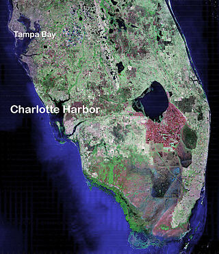
Charlotte Harbor Estuary, the second largest bay in Florida, is located on the Gulf of Mexico coast of west Florida with two thirds lying in Charlotte County, Florida and one in Lee County. The harbor's mouth is located behind Gasparilla Island, one of the many coastal barrier islands on the southwest coast of Florida, with access from the Gulf of Mexico through the Boca Grande Pass between Gasparilla Island on the north and Lacosta Island on the south. Charlotte Harbor covers about 270 sq mi (700 km2)

The Matanzas Pass Bridge is a bridge located in Fort Myers Beach, Florida. It carries State Road 865 between the Florida mainland and Estero Island, which is a major tourist destination. The bridge is one of the island's two connections to the mainland. The other is the Bonita Beach Causeway on the south end of the island.
Redfish Pass is a strait in Florida that connects Pine Island Sound with the Gulf of Mexico. It also separates Captiva Island on the south from North Captiva Island on the north. The pass was created by the hurricane of 1921 which divided the once larger Captiva Island. It is named after the many redfish caught in its channel soon after formation, and remains a popular sports fishing destination in Southwest Florida.
The Captiva Current is a newspaper that circulates around the island of Captiva off of Florida's southwest coast. The first issue was printed in August 1990 starring the chief of the island's fire department on the front page. It is printed weekly on Thursdays as a section of the Island Reporter.

Hurricane Ian was a deadly and extremely destructive Category 5 Atlantic hurricane, which was the third-costliest weather disaster on record worldwide, the deadliest hurricane to strike the state of Florida since the 1935 Labor Day hurricane, and the strongest hurricane to make landfall in Florida since Michael in 2018. Ian caused widespread damage across western Cuba, Florida, and the Carolinas. Ian was the ninth named storm, fourth hurricane, and second major hurricane of the 2022 Atlantic hurricane season. Ian was the first Category 5 hurricane in the Atlantic since Lorenzo in 2019.

The Sanibel-Captiva Conservation Foundation (SCCF) was founded in 1967 on Sanibel Island, Florida, with a mission to preserve the island's interior freshwater system. The nonprofit's mission has since evolved to protect and care for Southwest Florida's coastal ecosystems.

