Santa Rosa County, Florida

Last updated

Santa Rosa County
Milton, FL, Courthouse, Santa Rosa County, 12-16-2010 (1).JPG
Santa Rosa County Courthouse with Christmas decorations
Seal of Santa Rosa County, Florida.svg
Map of Florida highlighting Santa Rosa County.svg
Location within the U.S. state of Florida
Florida in United States.svg
Florida's location within the U.S.
Coordinates: 30°42′N87°01′W / 30.7°N 87.02°W / 30.7; -87.02
CountryFlag of the United States.svg United States
StateFlag of Florida.svg  Florida
FoundedFebruary 18, 1842
Named for Saint Rose of Viterbo
Seat Milton
Largest community Navarre
Area
  Total1,174 sq mi (3,040 km2)
  Land1,012 sq mi (2,620 km2)
  Water162 sq mi (420 km2)  13.8%
Population
 (2020)
  Total188,000 Increase2.svg
  Density160/sq mi (60/km2)
Time zone UTC−6 (Central)
  Summer (DST) UTC−5 (CDT)
Congressional district 1st
Website www.santarosa.fl.gov

Santa Rosa County is a county located in the northwestern portion of the U.S. state of Florida. As of 2020, the population was 188,000. The county seat is Milton, which lies in the geographic center of the county. Other major communities within Santa Rosa County are Navarre, Pace, and Gulf Breeze. [1] Navarre is the most populated community with a population of approximately 45,000 residents. Santa Rosa County is included in the PensacolaFerry PassBrent, Florida Metropolitan Statistical Area, which also includes Escambia County.

Contents

History

Santa Rosa County was created in 1842, when it was divided from Escambia County. It was named after the barrier island along its southern coast, which in turn had been named for the Roman Catholic saint, Rosa de Viterbo. [2]

Santa Rosa County repealed its prohibition on alcohol in 2005. [3]

Santa Rosa County has seen unprecedented growth in population, specifically in the communities of Navarre, Pace, and Gulf Breeze. The county is a quickly growing tourist destination because of its access to beaches and protected wilderness areas for kayaking, hiking, and camping. [4]

Geography

According to the U.S. Census Bureau, the county has a total area of 1,174 square miles (3,040 km2), of which 1,012 square miles (2,620 km2) is land and 162 square miles (420 km2) (13.8%) is water. [5]

National protected area

Regions

Santa Rosa County can be divided into three distinct sections: South Santa Rosa, Central Santa Rosa, and North Santa Rosa. The sections are centered on the main east–west roads that pass through the county.

Navarre Beach Navarre Beach Florida sand.jpg
Navarre Beach

South Santa Rosa County comprises the area from Holley and Navarre in the east to Gulf Breeze at the western end of the Fairpoint Peninsula, and along U.S. Highway 98. A section of Santa Rosa Island, containing the unincorporated community of Navarre Beach, is also part of South Santa Rosa County. Major bodies of water including Santa Rosa Sound, Pensacola Bay and East Bay strongly influence the housing and life style of citizens in the southern part of the county. This fast-growing region serves primarily as "bedroom communities" for Pensacola to the west and Hurlburt Field, Fort Walton Beach, and Eglin Air Force Base to the east.

Central Santa Rosa County is the area north of the bays and south of the extensive forests separating it from North Santa Rosa. The central section developed along the so-called Old Spanish Trail that ran from St. Augustine to New Orleans, and further points west. Today, U.S. Highway 90 closely parallels the old trail, and is the main highway that connects the region. Despite recent growth, the Central Region is best identified by its rural roots, and can be best characterized by traditional Southern culture. The Pace and Milton communities compose the Central Region, with both having populations roughly around 30,000. [6] [7] The county seat, Milton is located where the trail crossed the Blackwater River. To the west of Milton bordering the Escambia River, Pace has experienced exponential growth both residential and commercial. Interstate 10 also passes through this section of the county. The U.S. Navy presence is marked by Whiting Field and NOLF Spencer Field.

Northern Santa Rosa County is forest and farming country. The only town in the north is Jay. Most development has been along State Road 4 which runs through the northern sections of Escambia, Santa Rosa, and Okaloosa counties. A large oil and natural gas field around Jay produced a great deal of oil, and made many farmers millionaires in the 1970s and 1980s, but the field has been depleted and is producing little oil today. The citizens have, for the most part, returned to farming and forestry for their livelihoods.

State Road 87 traverses the county from north to south, between U.S. Highway 98 and the border with Escambia County, Alabama near Brewton, where it connects with State Route 41. This road is a primary emergency evacuation route for the county during hurricanes.

Adjacent counties

Government

Board of County Commissioners

The Board of County Commissioners serves as the legislative and policy setting body of Santa Rosa County as established under Section 125 of the Florida Statutes. As such, the board enacts all legislation and authorizes programs and expenditures within the county. The board appoints a professionally trained county administrator who is responsible for policy and budget development and implementation.

The board comprises five members, elected countywide. Members must reside within the particular districts for which they seek election. Each year the board organizes itself, selecting a chair and vice-chair from among its members to preside at commission meetings.

Current Santa Rosa County commissioners
DistrictCommissioner
1 (Pace/Central to western region)Sam Parker
2 (Milton/central to northeastern region)Kerry Smith
3 (Jay/central to northwestern region)James Calkins
4 (Navarre/southeastern region)Ray Eddington
5 (Gulf Breeze/southwestern region)Colton Wright

The commission meets in regular session beginning at 9:00 a.m. the second and fourth Thursday of the month in the Commissioner's Board Room in the Administrative Center, 6495 Caroline Street, in Milton. Called meetings and workshops are scheduled periodically and are advertised and open to the public.

County officials

OfficeOfficeholder
Supervisor of Elections Tappie A Villane
Property Appraiser Greg Brown II
Sheriff Bob Johnson
Tax Collector Stan Colie Nichols
Clerk of Courts Donald C Spencer

Demographics

Historical population
CensusPop.Note
1850 2,883
1860 5,48090.1%
1870 3,312−39.6%
1880 6,645100.6%
1890 7,96119.8%
1900 10,29329.3%
1910 14,89744.7%
1920 13,670−8.2%
1930 14,0833.0%
1940 16,08514.2%
1950 18,55415.3%
1960 29,54759.2%
1970 37,74127.7%
1980 55,98848.3%
1990 81,60845.8%
2000 117,74344.3%
2010 151,37228.6%
2020 188,00024.2%
2023 (est.)203,162 [8] 8.1%
U.S. Decennial Census [9]
1790-1960 [10] 1900-1990 [11]
1990-2000 [12] 2010-2019 [13]
Santa Rosa County racial composition as of 2020
(NH = Non-Hispanic) [lower-alpha 1]
RacePop 2010 [16] Pop 2020 [17] % 2010% 2020
White (NH)128,726147,51885.04%78.47%
Black or African American (NH)7,94010,6905.25%5.69%
Native American or Alaska Native (NH)1,1941,1120.79%0.59%
Asian (NH)2,6903,8181.78%2.03%
Pacific Islander (NH)2003620.13%0.19%
Some Other Race (NH)2188470.14%0.45%
Mixed/Multi-Racial (NH)3,8972.57%6.26%
Hispanic or Latino 6,50711,8904.3%6.32%
Total151,372188,000100.00%100.00%

As of the 2020 United States census, there were 188,000 people, 65,697 households, and 47,876 families residing in the county.

As of the census [18] of 2000, there were 117,743 people, 43,793 households, and 33,326 families residing in the county. The population density was 116 inhabitants per square mile (45/km2). There were 49,119 housing units at an average density of 48 per square mile (19/km2). The racial makeup of the county was 90.72% White, 4.25% Black or African American, 1.01% Native American, 1.30% Asian, 0.08% Pacific Islander, 0.67% from other races, and 1.98% from two or more races. 2.52% of the population were Hispanic or Latino of any race.

There were 43,793 households, out of which 36.50% had children under the age of 18 living with them, 62.20% were married couples living together, 10.20% had a female householder with no husband present, and 23.90% were non-families. 19.30% of all households were made up of individuals, and 6.60% had someone living alone who was 65 years of age or older. The average household size was 2.63 and the average family size was 3.00.

In the county, the population was spread out, with 26.60% under the age of 18, 7.20% from 18 to 24, 31.10% from 25 to 44, 24.10% from 45 to 64, and 11.00% who were 65 years of age or older. The median age was 37 years. For every 100 females, there were 100.60 males. For every 100 females age 18 and over, there were 97.90 males.

The median income for a household in the county was $41,881, and the median income for a family was $46,929. Males had a median income of $34,878 versus $22,304 for females. The per capita income for the county was $20,089. About 7.90% of families and 9.80% of the population were below the poverty line, including 12.60% of those under age 18 and 7.50% of those age 65 or over.

Libraries

The Santa Rosa County Library System has five branches located in the following communities: Navarre, Gulf Breeze, Jay, Milton, and Pace.

Communities

The largest communities are Navarre and Pace.

Cities

Town

Census-designated places

Politics

United States presidential election results for Santa Rosa County, Florida [19]
Year Republican Democratic Third party
No.%No.%No.%
2020 77,38572.19%27,61225.76%2,2012.05%
2016 65,33973.68%18,46420.82%4,8815.50%
2012 58,18675.51%17,76823.06%1,1061.44%
2008 55,97273.28%19,47025.49%9351.22%
2004 52,05977.35%14,65921.78%5890.88%
2000 36,33972.10%12,81825.43%1,2452.47%
1996 26,30162.02%10,93625.79%5,17312.20%
1992 17,33952.90%6,55620.00%8,88227.10%
1988 18,97377.85%5,25421.56%1430.59%
1984 21,26582.04%4,64917.94%60.02%
1980 13,80263.93%6,96432.26%8243.82%
1976 9,12252.39%8,02046.06%2701.55%
1972 12,66988.94%1,49110.47%850.60%
1968 2,56720.19%1,60012.58%8,54967.23%
1964 5,98362.63%3,57037.37%00.00%
1960 2,77735.89%4,96064.11%00.00%
1956 1,90931.54%4,14468.46%00.00%
1952 1,74428.50%4,37571.50%00.00%
1948 54915.58%2,31665.72%65918.70%
1944 86224.85%2,60775.15%00.00%
1940 65618.40%2,91081.60%00.00%
1936 74420.23%2,93479.77%00.00%
1932 31510.09%2,80689.91%00.00%
1928 1,62873.97%54124.58%321.45%
1924 22923.34%69370.64%596.01%
1920 33328.88%81370.51%70.61%
1916 11110.23%89682.58%787.19%
1912 707.84%59266.29%23125.87%
1908 21226.40%53566.63%566.97%
1904 7313.30%40373.41%7313.30%
1900 386.47%51988.42%305.11%
1896 43136.68%69459.06%504.26%
1892 00.00%45283.86%8716.14%

Transportation

Airports

Highways

Santa Rosa County contains many highways, which include Navarre Parkway and Gulf Breeze Parkway (US 98), Interstate 10, Avalon Boulevard, and Highways 4, 87, 89, and 90.

See also

Notes

  1. Note: the US Census treats Hispanic/Latino as an ethnic category. This table excludes Latinos from the racial categories and assigns them to a separate category. Hispanics/Latinos can be of any race. [14] [15]

Related Research Articles

<span class="mw-page-title-main">Escambia County, Florida</span> County in Florida, United States

Escambia County is the westernmost and oldest county in the U.S. state of Florida. It is in the state's northwestern corner. At the 2020 census, the population was 321,905. Its county seat and largest city is Pensacola. Escambia County is included within the Pensacola—Ferry Pass—Brent, Florida Metropolitan Statistical Area. The county population has continued to increase as the suburbs of Pensacola have developed.

<span class="mw-page-title-main">Okaloosa County, Florida</span> County in Florida, United States

Okaloosa County is located in the northwestern portion of the U.S. state of Florida, extending from the Gulf of Mexico to the Alabama state line. As of the 2020 census, the population was 211,668. Its county seat is Crestview. Okaloosa County is included in the Crestview-Fort Walton Beach-Destin, FL Metropolitan Statistical Area.

<span class="mw-page-title-main">Walton County, Florida</span> County in Florida, United States

Walton County is located on the Emerald Coast in the northwestern part of the U.S. state of Florida, with its southern border on the Gulf of Mexico. As of the 2020 census, the population was 75,305. Its county seat is DeFuniak Springs. The county is home to the highest natural point in Florida: Britton Hill, at 345 feet (105 m). Walton County is included in the Crestview–Fort Walton Beach–Destin Metropolitan Statistical Area.

<span class="mw-page-title-main">Pensacola, Florida</span> City in Florida, United States

Pensacola is the westernmost city in the Florida Panhandle. It is the county seat and only incorporated city of Escambia County, Florida, United States. At the 2020 census, the population was 54,312, up from 51,923 at the 2010 census. It is the principal city of the Pensacola—Ferry Pass—Brent, Florida Metropolitan Statistical Area, which had 509,905 residents in 2020.

<span class="mw-page-title-main">Destin, Florida</span> City in Florida, United States of America

Destin is a city located in Okaloosa County, Florida, United States. It is a principal city of the Crestview–Fort Walton Beach–Destin metropolitan area.

<span class="mw-page-title-main">Fort Walton Beach, Florida</span> City in Florida

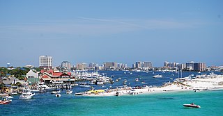
Fort Walton Beach, often referred to by the initialism FWB, a city in southern Okaloosa County, Florida, United States. As of the 2020 U.S. census, the population was 20,922, up from 19,507 in 2010. It is the principal city of the Fort Walton Beach−Crestview−Destin Metropolitan Statistical Area.

<span class="mw-page-title-main">Gulf Breeze, Florida</span> City in Florida, United States

Gulf Breeze is a city in Santa Rosa County, Florida. It is a suburb of Pensacola, and is in the Pensacola—Ferry Pass—Brent, Florida Metropolitan Statistical Area. The population was 6,340 at the 2020 census, up from 5,763 at the 2010 census.

<span class="mw-page-title-main">Jay, Florida</span> Town in the state of Florida, United States

Jay is a town in Santa Rosa County, Florida, United States. Located in the Florida Panhandle in North Florida, it is part of the Pensacola––Ferry Pass–Brent, Florida Metropolitan Statistical Area. The population was 524 at the 2020 census, down from 533 at the 2010 census.

<span class="mw-page-title-main">Pace, Florida</span> Unincorporated Area in Florida, United States

Pace is an unincorporated community in Santa Rosa County, Florida. It is the second largest community in Santa Rosa County, and is a part of the Pensacola—Ferry Pass—Brent, Florida Metropolitan Statistical Area. Pace has experienced exponential growth, and has evolved from a small, rural community to a thriving bedroom community of Pensacola with growing residential and commercial options. As of the 2020 United States census, the population was 24,684, up from 20,093 at the 2010 census. From 2000 to 2010, the Pace CDP population growth percentage was 171.1%, and from 2010 to 2020, the population growth percentage was 22.8%.

<span class="mw-page-title-main">Pensacola Beach, Florida</span> Unincorporated Community in Florida, United States

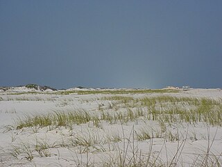
Pensacola Beach is an unincorporated community located on Santa Rosa Island, a barrier island, in Escambia County, Florida, United States. It is situated south of Pensacola in the Gulf of Mexico. As of the 2000 census, the community had a total population of 2,738. It has been described as "famous" for its ultra-white sand beaches.

<span class="mw-page-title-main">Florida panhandle</span> Northwest region of Florida

The Florida panhandle is the northwestern part of the U.S. state of Florida. It is a salient roughly 200 miles (320 km) long, bordered by Alabama on the north and the west, Georgia on the north, and the Gulf of Mexico to the south. Its eastern boundary is arbitrarily defined. It is defined by its southern culture and rural geography relative to the rest of Florida, as well as closer cultural links to French-influenced Louisiana, Mississippi, and Alabama. Its major communities include Pensacola, Navarre, Destin, Panama City Beach, and Tallahassee.

<span class="mw-page-title-main">Santa Rosa Island (Florida)</span> Island of Pensacola in Florida, United States

Santa Rosa Island is a 40-mile (64 km) barrier island located in the U.S. state of Florida, thirty miles (50 km) east of the Alabama state border. The communities of Pensacola Beach, Navarre Beach, and Okaloosa Island are located on the island. On the northern side of the island, are Pensacola Bay on the west and Choctawhatchee Bay on the east, joined through Santa Rosa Sound.

<span class="mw-page-title-main">Emerald Coast</span> Region in Florida, United States

The Emerald Coast is an unofficial name for the coastal area in the US state of Florida on the Gulf of Mexico that stretches about 100 miles (160 km) through five counties, Escambia, Santa Rosa, Okaloosa, Walton, and Bay, which include Pensacola Beach, Navarre Beach, Fort Walton Beach, Destin, and Panama City Beach. Some south Alabama communities on the coast of Baldwin County, such as Gulf Shores, Orange Beach, and Fort Morgan embrace the term as well.

<span class="mw-page-title-main">Navarre, Florida</span> Census-designated place and unincorporated community in Florida, US

Navarre is a census-designated place and unincorporated community in Santa Rosa County in the northwest Florida Panhandle. It is a major bedroom community for mostly U.S. military personnel, federal civil servants, local population, retirees and defense contractors. Due to Navarre Beach and the 4 miles (6.4 km) of beach front on the Gulf of Mexico thereof, as well as several miles of beaches within the Navarre Beach Marine Park and the Gulf Islands National Seashore, it has a small, but rapidly growing community of nature enthusiasts and tourists. Navarre has grown from being a small town of around 1,500 in 1970 to a town with a population estimated at 43,540 as of 2022, if including both the Navarre and Navarre Beach Census Designated Places. The Navarre CDP recorded a population of 40,817 at the 2020 census.

<span class="mw-page-title-main">Florida's 1st congressional district</span> U.S. House district for Florida

Florida's 1st congressional district is a congressional district in the U.S. state of Florida, covering the state's western Panhandle. It includes all of Escambia, Okaloosa, Santa Rosa counties, and portions of Walton county. The district is anchored in Pensacola and also includes the large military bedroom communities and tourist destinations of Navarre and Fort Walton Beach and stretches along the Emerald Coast. The district is currently represented by Republican Matt Gaetz. With a Cook Partisan Voting Index rating of R+19, it is the most Republican district in Florida.

Santa Rosa Sound is a sound connecting Pensacola Bay and Choctawhatchee Bay in Florida. The northern shore consists of the Fairpoint Peninsula and portions of the mainland in Santa Rosa County and Okaloosa County. It is bounded to the south by Santa Rosa Island, separating it from the Gulf of Mexico.

The Fairpoint Peninsula, also referred to as the Gulf Breeze Peninsula or the Navarre Peninsula or historically the Santa Rosa Peninsula, is located in northwest Florida between Santa Rosa Sound and Pensacola Bay.

<span class="mw-page-title-main">Pensacola metropolitan area</span> Metropolitan Statistical Area in Florida, United States

The Pensacola metropolitan area is the metropolitan area centered on Pensacola, Florida. It is also known as the Pensacola–Ferry Pass–Brent Metropolitan Statistical Area, a metropolitan statistical area (MSA) used for statistical purposes by the United States Census Bureau and other agencies. The Pensacola Standard Metropolitan Statistical Area was first defined in 1958, with Pensacola as the principal city, and included Escambia and Santa Rosa counties. The MSA was renamed Pensacola–Ferry Pass–Brent MSA in 2003, with the unincorporated census-designated places Ferry Pass and Brent added as principal cities. The population of the MSA in the 2020 census was 511,502.

Midway is an unincorporated community and census designated place (CDP) in southern Santa Rosa County, Florida, United States. It is part of the Pensacola–Ferry Pass–Brent, Florida Metropolitan Statistical Area. The area is located between the communities of Gulf Breeze and Navarre, on the Fairpoint Peninsula. Midway is often considered to be part of one, if not both, of these communities. Its actual boundaries vary from source to source, but unofficially include most areas from the intersection of Soundside Drive with U.S. Highway 98, eastward until Highway 98 becomes Navarre Parkway.

Woodlawn Beach is a census-designated place on Santa Rosa Sound in Santa Rosa County, Florida, United States surrounded by the older Midway CDP. The population was 2,741 at the 2020 census, up from 1,785 at the 2010 Census. It is part of the Pensacola—Ferry Pass—Brent, Florida Metropolitan Statistical Area. It lies south of U.S. Highway 98 between Nantahala Beach Road and Conover Cove, and includes the Woodlawn Beach Middle School, Woodlawn Beach Boat Ramp, and Gulf Breeze Zoo. Citizens of Woodlawn Beach often consider themselves to be part of the larger communities of Navarre or Gulf Breeze. The ZIP Code for Woodlawn Beach is 32563.

References

  1. "Find a County". National Association of Counties. Retrieved June 7, 2011.
  2. Publications of the Florida Historical Society. Florida Historical Society. 1908. p. 34.
  3. "Suwannee Votes Wet". Suwannee Democrat. August 16, 2011. Archived from the original on January 7, 2014. Retrieved January 7, 2014.
  4. "Blackwater River State Park". Florida State Park.{{cite web}}: CS1 maint: url-status (link)
  5. "US Gazetteer files: 2010, 2000, and 1990". United States Census Bureau. February 12, 2011. Retrieved April 23, 2011.
  6. "Zip Code 32570 Profile, Map and Demographics - Updated December 2019". Zipdatamaps.com. Retrieved December 31, 2019.
  7. "Zip Code 32571 Profile, Map and Demographics - Updated December 2019". Zipdatamaps.com. Retrieved December 31, 2019.
  8. "Annual Estimates of the Resident Population for Counties: April 1, 2020 to July 1, 2023". United States Census Bureau. Retrieved March 31, 2024.
  9. "U.S. Decennial Census". United States Census Bureau. Retrieved June 16, 2014.
  10. "Historical Census Browser". University of Virginia Library. Retrieved June 16, 2014.
  11. "Population of Counties by Decennial Census: 1900 to 1990". United States Census Bureau. Retrieved June 16, 2014.
  12. "Census 2000 PHC-T-4. Ranking Tables for Counties: 1990 and 2000" (PDF). United States Census Bureau. Retrieved June 16, 2014.
  13. "State & County". United States Census Bureau.
  14. https://www.census.gov/ [ not specific enough to verify ]
  15. "About the Hispanic Population and its Origin". www.census.gov. Retrieved May 18, 2022.
  16. "Explore Census Data". data.census.gov. Retrieved May 27, 2022.
  17. "Explore Census Data". data.census.gov. Retrieved May 27, 2022.
  18. "U.S. Census website". United States Census Bureau . Retrieved May 14, 2011.
  19. Leip, David. "Dave Leip's Atlas of U.S. Presidential Elections". uselectionatlas.org. Retrieved June 15, 2018.

Newspapers

Print:

Digital only:

Government links/constitutional offices

Special districts

Judicial branch

Community and civic organizations

Hospitals

30°42′N87°01′W / 30.70°N 87.02°W / 30.70; -87.02