Ellenton, Florida

Last updated

Ellenton, Florida
Gamble Plantation SP mansion01.jpg
Gamble Plantation Mansion
Manatee County Florida Incorporated and Unincorporated areas Ellenton Highlighted.svg
Location in Manatee County and the state of Florida
Coordinates: 27°31′22″N82°31′33″W / 27.52278°N 82.52583°W / 27.52278; -82.52583
CountryFlag of the United States.svg  United States
State Flag of Florida.svg  Florida
County   Manatee
Government
  TypeNone
Area
[1]
  Total4.47 sq mi (11.57 km2)
  Land3.31 sq mi (8.56 km2)
  Water1.16 sq mi (3.00 km2)
Elevation
10 ft (3 m)
Population
 (2020) [2]
  Total4,129
  Density1,248.56/sq mi (482.09/km2)
Time zone UTC-5 (Eastern (EST))
  Summer (DST) UTC-4 (EDT)
ZIP codes
34222 (Ellenton)
34221 (Palmetto)
Area code 941
FIPS code 12-20375 [3]
GNIS feature ID0282171 [4]

Ellenton is an unincorporated community and census-designated place (CDP) in Manatee County, Florida, United States. The population was 4,129 at the 2020 census, down from 4,275 at the 2010 census. [2] It is part of the North Port-Bradenton-Sarasota, Florida Metropolitan Statistical Area.

Contents

History

The oldest structure in Ellenton is the Gamble Plantation, which was built between 1845 and 1850 by Major Robert Gamble. Originally a sugar plantation worked by slaves, the antebellum mansion fell into disrepair after the Civil War. Major George Patten and his wife, Mary, purchased the property in 1870 and named the area "Ellenton" after his daughter Ellen. [5] In 1881, the United States government designated Ellenton as an official post office site. [6]

A refining plant for fuller's earth located in Ellenton along the Manatee River opened in 1903. It was owned by the Atlantic Refining Company and had 150+ employees being the biggest refinery the company owned. It burned down once in 1908 and again in 1912. In 1922, it burned down for the final time after which it was permanently closed. [7]

Geography

Ellenton is located in central Manatee County at 27°31′22″N82°31′33″W / 27.52278°N 82.52583°W / 27.52278; -82.52583 (27.522666, -82.525867). [8] It is on the north side of the tidal Manatee River and is bordered to the west by the city of Palmetto. Unincorporated Memphis is to the northwest.

U.S. Route 301 passes through the center of the community, and Interstate 75 forms the eastern border, with the highways intersecting at Exit 224 on I-75. US 301 leads west into Palmetto and then south across the Manatee River into Bradenton, the county seat, while to the northeast it leads 8 miles (13 km) to Parrish. I-75 leads north 32 miles (51 km) to the east side of Tampa and south 85 miles (137 km) to Fort Myers.

According to the United States Census Bureau, the Ellenton CDP has a total area of 4.5 square miles (12 km2), of which 3.3 square miles (8.5 km2) are land and 1.2 square miles (3.1 km2), or 25.95%, are water. [1]

Demographics

Historical population
CensusPop.Note
1970 1,421
1980 1,5619.9%
1990 2,57364.8%
2000 3,14222.1%
2010 4,27536.1%
2020 4,129−3.4%
source: [9]

As of the 2020 census, [10] Ellenton had a population of 4,129 people with 1,847 households. There were 2,055 housing units. There was an employment rate of 46.1%. The median household income was $59,723. 11.2% of the population lived below the poverty threshold.

46.9% of the population 25 years or older had a High School or equivalent degree. 10.5% of the population 25 years and older had a bachelor's degree or higher.

20.7% of the population spoke Spanish at home, 0.4% spoke other Indo-European languages, and 0.3% spoke Asian and Pacific Islander languages at home. 9.0% of the population were foreign born persons. 28.2% were 65 years or older.

Industry

January 2012 - Feld Entertainment purchased the Palmetto Corporate Center, a former Siemens Corp. complex here and plans to move most of its various operations and its world headquarters there over a five-year period starting with its worldwide production center. [11]

1900 - Fuller's Earth Plant mined clay to be used as bleaching agent and as an absorbent for oil and fat. [12]

1850s to present - Agriculture was an important industry, starting with sugarcane from Gamble Plantation. This was harvested through slave labor up until the Civil War. Vegetable farms and citrus groves are also important industries in Ellenton. [13]

Related Research Articles

<span class="mw-page-title-main">Manatee County, Florida</span> County in Florida, United States

Manatee County is a county in the U.S. state of Florida. As of the 2020 US Census, the population was 399,710. Manatee County is part of the North Port-Bradenton-Sarasota, Florida Metropolitan Statistical Area. Its county seat and largest city is Bradenton. The county was created in 1855 and named for the Florida manatee, Florida's official marine mammal. Features of Manatee County include access to the southern part of the Tampa Bay estuary, the Sunshine Skyway Bridge, and the Manatee River.

<span class="mw-page-title-main">Manasota Key, Florida</span> Census-designated place in Florida, United States

Manasota Key is a census-designated place (CDP) consisting mainly of the community of Englewood Beach in Charlotte County, Florida, United States. The population of the CDP was 1,326 at the 2020 census, up from 1,229 at the 2010 census. It is part of the Punta Gorda, Florida Metropolitan Statistical Area, included in the North Port-Bradenton, Florida Combined Statistical Area.

<span class="mw-page-title-main">Manatee Road, Florida</span> Census-designated place in Florida, United States

Manatee Road is a census-designated place (CDP) in Levy County, Florida, United States. The population was 2,244 at the 2010 census. At the 2000 census, the CDP was misspelled as "Manattee Road".

<span class="mw-page-title-main">Bayshore Gardens, Florida</span> Census-designated place in Florida, United States

Bayshore Gardens is a census-designated place (CDP) and planned community in Manatee County, Florida, United States. The population was 19,904 at the 2020 census, up from 16,323 in 2010. It is part of the North Port-Bradenton-Sarasota, Florida Metropolitan Statistical Area.

<span class="mw-page-title-main">Bradenton, Florida</span> City in Florida, United States

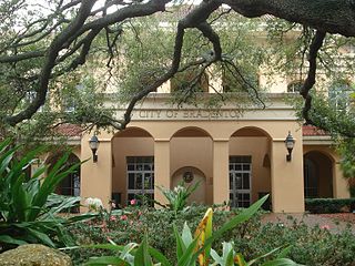
Bradenton is a city in and the county seat of Manatee County, Florida, United States. As of the 2020 census, the city's population is 55,698, up from 49,546 at the 2010 census. It is a principal city in the North Port-Bradenton-Sarasota, Florida Metropolitan Statistical Area. Downtown Bradenton is along the Manatee River and includes the Bradenton Riverwalk. Downtown Bradenton is also home to the Bishop Museum of Science and Nature.

<span class="mw-page-title-main">Bradenton Beach, Florida</span> City in Florida, United States

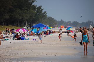
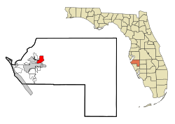
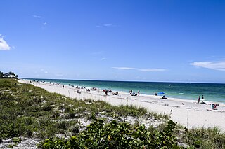
Bradenton Beach is a city on Anna Maria Island in Manatee County, Florida, United States. The population was 908 at the 2020 census, down from 1,171 in 2010. It is part of the North Port-Bradenton-Sarasota, Florida Metropolitan Statistical Area.

<span class="mw-page-title-main">Cortez, Florida</span> Census-designated place in Florida, United States

Cortez, a census-designated place (CDP) in Manatee County, Florida, United States, is a small Gulf Coast commercial fishing village that was founded by settlers from North Carolina in the 1880s. The population was 4,121 at the 2020 census, down from 4,241 at the 2010 census. It is part of the North Port-Bradenton-Sarasota, Florida Metropolitan Statistical Area.

<span class="mw-page-title-main">Memphis, Florida</span> Census-designated place in Florida, United States

Memphis is an unincorporated community and census-designated place (CDP) in Manatee County, Florida, United States. The population was 9,024 as of the 2020 census, up from 7,848 in 2010. It is part of the North Port–Bradenton–Sarasota, Florida Metropolitan Statistical Area.

<span class="mw-page-title-main">Palmetto, Florida</span> City in Florida, United States

Palmetto is a city in Manatee County, Florida, United States. As of the 2020 census, the population was listed as 13,323, up from 12,606 at the 2010 census. It is part of the North Port–Bradenton–Sarasota, Florida Metropolitan Statistical Area.

<span class="mw-page-title-main">Samoset, Florida</span> Census-designated place in Florida, United States

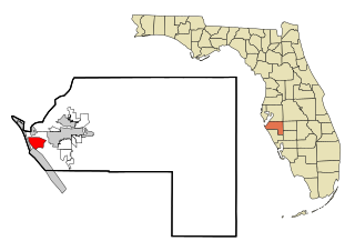
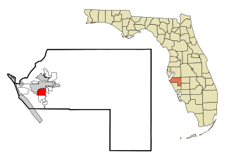
Samoset is an unincorporated community and census-designated place (CDP) in Manatee County, Florida, United States. The population was 4,146 at the 2020 census, up from 3,854 in 2010. It is part of the North Port–Bradenton–Sarasota, Florida Metropolitan Statistical Area.

<span class="mw-page-title-main">South Bradenton, Florida</span> Census-designated place in Florida, United States

South Bradenton is an unincorporated community and census-designated place (CDP) in Manatee County, Florida, United States. The population was 26,858 at the 2020 census, up from 22,178 in 2010. It is part of the North Port–Bradenton–Sarasota, Florida Metropolitan Statistical Area.

<span class="mw-page-title-main">West Bradenton, Florida</span> Census-designated place in Florida, United States

West Bradenton is an unincorporated area and census-designated place (CDP) in Manatee County, Florida, United States. The population was 4,247 at the 2020 census, up from 4,192 at the 2010 census. It is part of the North Port–Bradenton–Sarasota, Florida Metropolitan Statistical Area.

<span class="mw-page-title-main">West Samoset, Florida</span> Census-designated place in Florida, United States

West Samoset is an unincorporated area and census-designated place (CDP) in Manatee County, Florida, United States. The population was 6,482 at the 2020 census, up from 5,583 in 2010. It is part of the North Port–Bradenton–Sarasota, Florida Metropolitan Statistical Area.

<span class="mw-page-title-main">Whitfield, Manatee County, Florida</span> Census-designated place in Florida, United States

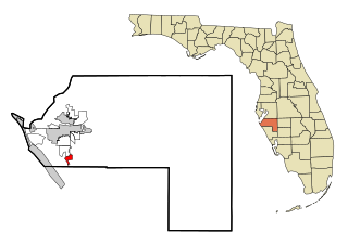
Whitfield, also known as Whitfield Estates, is an unincorporated community and census-designated place (CDP) in Manatee County, Florida, United States. As of the 2020 census it had a population of 2,989, up from 2,882 at the 2010 census. It is part of the North Port–Bradenton–Sarasota, Florida Metropolitan Statistical Area. It receives its mail from the Sarasota post office located in Sarasota County.

<span class="mw-page-title-main">Palmetto Estates, Florida</span> Census-designated place in Florida

Palmetto Estates is an unincorporated area and census-designated place (CDP) in Miami-Dade County, Florida, United States. It is part of the Miami metropolitan area of South Florida. The population was 13,498 at the 2020 census.

<span class="mw-page-title-main">Sun City Center, Florida</span> Census-designated place in Florida, United States

Sun City Center is an unincorporated census-designated place (CDP) in southern Hillsborough County, Florida, United States. It is located south of Tampa and north of Sarasota on I-75. As of the 2020 census, the population was 30,952. The ZIP Code serving the community is 33573.

<span class="mw-page-title-main">Gamble Plantation Historic State Park</span> Florida State Park in Ellenton, Florida

The Judah P. Benjamin Confederate Memorial at Gamble Plantation Historic State Park, also known as the Gamble Mansion or Gamble Plantation, is a Florida State Park, located in Ellenton, Florida, on 37th Avenue East and US 301. It is home to the Florida Division United Daughters of the Confederacy (UDC).

<span class="mw-page-title-main">Sarasota metropolitan area</span> Metropolitan area in Florida, United States

The Sarasota metropolitan area is a metropolitan area located in Southwest Florida. The metropolitan area is defined by the Office of Management and Budget (OMB) as the North Port–Bradenton–Sarasota Metropolitan Statistical Area, a metropolitan statistical area (MSA) consisting of Manatee County and Sarasota County. The principal cities listed by the OMB for the MSA are North Port, Bradenton, Sarasota, Lakewood Ranch, and Venice. At the 2020 census, the MSA had a population of 833,716. The Census Bureau estimates that its population was 891,411 in 2022.

Lakewood Ranch is a planned community and census-designated place (CDP) in southeastern Manatee County and northeastern Sarasota County, Florida, United States, consisting of approximately 31,000 acres (13,000 ha). It is part of the North Port-Bradenton-Sarasota, Florida Metropolitan Statistical Area. According to the 2020 census, the CDP had a population of 34,877.

The Manatee County Public Library is a public library that provides services and resources to the communities and visitors of Manatee County. It is a division of the Manatee County Government's Community and Veterans Services Department located in Manatee County, Florida. The library system provides patrons with in-person resources such as books, movies, and music, as well as online databases to access e-books, e-audiobooks, journal articles, magazines, and other resources. Library services include free events for the public, one-on-one learning sessions, and computers and other technological equipment available for public use. Library cards are provided at no charge to those who reside, own property, attend school, or work in Manatee County.

References

  1. 1 2 "2022 U.S. Gazetteer Files: Florida". United States Census Bureau. Retrieved December 15, 2022.
  2. 1 2 "P1. Race – Ellenton CDP, Florida: 2020 DEC Redistricting Data (PL 94-171)". U.S. Census Bureau. Retrieved December 15, 2022.
  3. "U.S. Census website". United States Census Bureau . Retrieved January 31, 2008.
  4. "US Board on Geographic Names". United States Geological Survey. October 25, 2007. Retrieved January 31, 2008.
  5. Reed, S. (January 2004). Ellenton evolves: once the home of agriculture and southern history, this Manatee community is becoming much, much more. Sarasota Magazine, 26(4), M12+. Retrieved from http://go.galegroup.com/ps/i.do?id=GALE%7CA112907042&v=2.1&u=23950_mtcpls&it=r&p=ITOF&asid=b6e270f80b9abf60428e98235431e458
  6. Wiggins, J. (2003). Ellenton: its early years. Kearney, NE: Morris.
  7. Publishing Co., Valentine & Sons' (1909). "Fuller's Earth Works, Ellenton" (TIFF). Manatee County Public Library System: Digital Collection (Postcard). Archived from the original on May 21, 2021. Retrieved May 21, 2021.
  8. "US Gazetteer files: 2010, 2000, and 1990". United States Census Bureau. February 12, 2011. Retrieved April 23, 2011.
  9. "Characteristics of the Population" (PDF). U.S. Census Bureau . Retrieved July 19, 2020.
  10. "Ellenton CDP, Florida". census.gov. United States Census Bureau. Retrieved January 31, 2023.
  11. Sword, Doug; Michael Pollick (January 31, 2012). "Feld Entertainment moving headquarters to Ellenton". Herald-Tribune. Retrieved May 11, 2013.
  12. Wiggins, J. (2003). Ellenton: its early years. Kearney, NE: Morris.
  13. Wiggins, J.(2003). Ellenton: its early years. Kearney, NE: Morris.