
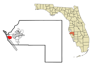
Manatee County is a county in the U.S. state of Florida. As of the 2020 US Census, the population was 399,710. Manatee County is part of the Bradenton-Sarasota-Venice, Florida Metropolitan Statistical Area. Its county seat and largest city is Bradenton. The county was created in 1855 and named for the Florida manatee, Florida's official marine mammal. Features of Manatee County include access to the southern part of the Tampa Bay estuary, the Sunshine Skyway Bridge, and the Manatee River.

Bayshore Gardens is a census-designated place (CDP) and planned community in Manatee County, Florida, United States. The population was 19,904 at the 2020 census, up from 16,323 in 2010. It is part of the Bradenton-Sarasota-Venice, Florida Metropolitan Statistical Area.
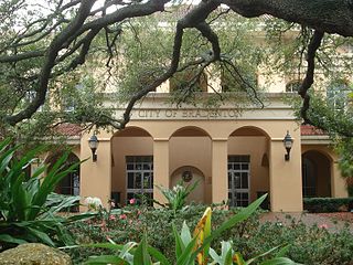
Bradenton is a city in and the county seat of Manatee County, Florida, United States. As of the 2020 census, the city's population is 55,698. Downtown Bradenton is along the Manatee River and includes the Bradenton Riverwalk. Downtown Bradenton is also home to the Bishop Museum of Science and Nature.
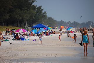
Bradenton Beach is a city on Anna Maria Island in Manatee County, Florida, United States. The population was 908 at the 2020 census, down from 1,171 in 2010. It is part of the Bradenton-Sarasota-Venice, Florida Metropolitan Statistical Area.
Cortez, a census-designated place (CDP) in Manatee County, Florida, United States, is a small Gulf Coast commercial fishing village that was founded by settlers from North Carolina in the 1880s. The population was 4,121 at the 2020 census. It is part of the Bradenton-Sarasota-Venice, Florida Metropolitan Statistical Area.

Longboat Key is a town in Manatee and Sarasota counties along the central west coast of the U.S. state of Florida, located on and coterminous with the barrier island of the same name. Longboat Key is south of Anna Maria Island, between Sarasota Bay and the Gulf of Mexico. It is almost equally divided between the Manatee and Sarasota counties. The town of Longboat Key was incorporated in 1955 and is part of the Bradenton-Sarasota-Venice, Florida Metropolitan Statistical Area. The town's population was 7,505 at the 2020 census.

Palmetto is a city in Manatee County, Florida, United States. As of the 2020 census, the population was listed as 13,323. It is part of the North Port–Sarasota–Bradenton metropolitan statistical area.

West Bradenton is an unincorporated area and census-designated place (CDP) in Manatee County, Florida, United States. The population was 4,247 at the 2020 census. It is part of the Bradenton–Sarasota–Venice Metropolitan Statistical Area.
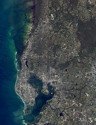
The Tampa Bay area is a major metropolitan area surrounding Tampa Bay on the Gulf Coast of Florida in the United States. It includes the main cities of Tampa, St. Petersburg, and Clearwater. It is the 17th-largest metropolitan area in the United States, with a population of 3,175,275 as of the 2020 U.S. Census.

Southwest Florida is the region along the southwest Gulf coast of the U.S. state of Florida. The area is known for its beaches, subtropical landscape, and winter resort economy.
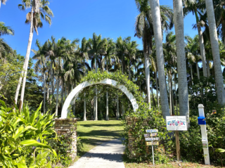
Palma Sola Botanical Park is a botanical garden located at 9800 17th Avenue N.W. Bradenton, Florida, United States. The park showcases collections of rare palms, fruits, and flowering trees, as well as three lakes, a butterfly garden, gazebo, and pavilion. It is open daily without charge.

Pine Level is a ghost town in DeSoto County, Florida, United States.

The Sarasota metropolitan area is a metropolitan area located in Southwest Florida. The metropolitan area is defined by the Office of Management and Budget (OMB) as the North Port–Bradenton–Sarasota Metropolitan Statistical Area, a metropolitan statistical area (MSA) consisting of Manatee County and Sarasota County. The principal cities listed by the OMB for the MSA are North Port, Bradenton, Sarasota, Lakewood Ranch, and Venice. At the 2020 census, the MSA had a population of 833,716. The Census Bureau estimates that its population was 891,411 in 2022.

Terra Ceia is an unincorporated community in Manatee County, Florida, United States that includes the 1,932 acres (7.82 km2) Terra Ceia Preserve. It is located on Terra Ceia Island near the Southern shore of Tampa Bay near the intersection of US 19 and I-275, at the southern end of the Sunshine Skyway Bridge. It is surrounded by Tampa Bay to the north and west, Rubonia to the east, and Terra Ceia Bay to the south.

Anna Maria Island, is a barrier island on the coast of Manatee County, Florida, in the United States. It is bounded on the west by the Gulf of Mexico, on the south by Longboat Pass, on the east by Anna Maria Sound, and on the north by Tampa Bay. Anna Maria Island is approximately 7 miles (11 km) long north to south.
The following is an alphabetical list of articles related to the U.S. state of Florida.
Myakka City is an unincorporated community in southeastern Manatee County, Florida, United States. It lies along State Road 70 near the city of Bradenton, the county seat of Manatee County. Its elevation is 43 feet (13 m), and it is located at 27°20′59″N82°9′41″W. Although Myakka is unincorporated, it has a post office, with the ZIP code of 34251; the ZCTA for ZIP code 34251 had a population of 6,351 at the 2010 census. up from 4,239 in 2000.
Manhattan was a proposed city in a development that was located in northern Manatee County, Florida near the present-day town of Parrish during the Florida land boom in the 1920s. The town was intended to be the centerpiece of an agricultural community called Manatee River Park Estates.
Rye is an unincorporated community in Manatee County, Florida.
Perico Island is a small island just west of the Palma Sola area in Manatee County. It is a residential community with a hotel, marina, and several natural preserve areas.


